Mori Atlas logo
Nature reserveRéserve naturelle régionale du marais de Galuchet et des boucles de la Sèvre Niortaise

Mapping the floodplain meadows and river meanders within the urban conservation landscape of western France

Réserve naturelle régionale du marais de Galuchet et des boucles de la Sèvre Niortaise Protected Wetland Landscape

The Réserve naturelle régionale du marais de Galuchet et des boucles de la Sèvre Niortaise represents a significant urban protected area in the city of Niort. This wetland site features a complex mosaic of floodplain meadows, riparian woodlands, and marsh vegetation connected by a network of waterways. As a designated regional nature reserve, the site protects twelve habitats of community interest and provides essential ecological corridors within the Nouvelle-Aquitaine region.

wetlandmarshfloodplainurban nature reserveregional nature reserveriver meanders

Réserve naturelle régionale du marais de Galuchet et des boucles de la Sèvre Niortaise

Nature reserve

Park overview

Structured park overview, official facts, and landscape profile for Galuchet Marsh and Sèvre Niortaise Meanders Regional Nature Reserve

Galuchet Marsh and Sèvre Niortaise Meanders Regional Nature Reserve park facts, protected area profile, and essential visitor context

Review the core facts for Galuchet Marsh and Sèvre Niortaise Meanders Regional Nature Reserve, including designation, size, terrain, visitor scale, habitats, and operating context in one park-focused overview.

About Galuchet Marsh and Sèvre Niortaise Meanders Regional Nature Reserve

The Galuchet Marsh and Sèvre Niortaise Meanders Regional Nature Reserve is a young but strategically important protected area located in Niort, the prefecture of the Deux-Sèvres département in the Nouvelle-Aquitaine region of western France. Spanning approximately 151 hectares, the reserve stretches on both sides of the Sèvre Niortaise, the river that defines much of the region's hydrological and ecological character. Its creation in June 2025 marked an institutional milestone, as it became the first regional nature reserve in France to be fully integrated within an urban context.

The reserve's defining feature is its wetland habitat mosaic. The landscape combines wooded areas, marsh, and paludal vegetation with open grasslands, wet floodplain meadows, and an extensive network of waterways including the river itself and surrounding canals. Cultivated plots also form part of the mosaic, illustrating how traditional land use continues to coexist with more strictly natural habitats. About one third of the reserve consists of natural wet meadows, which give the area much of its visual and ecological identity.

Ecologically, the reserve is significant because it encompasses twelve habitats of community interest under European habitat classifications, with four of these classified as priority habitats. This richness reflects the diversity of conditions created by the Sèvre Niortaise, a coastal river whose meanders and floodplain dynamics shape the surrounding terrain. Old ash trees with cavities provide biotopes for bats and saproxylic insects, including the Alpine longhorn beetle (Rosalia alpina), while the open wetland landscape supports a notable breeding colony of grey herons and a broader range of wetland-associated fauna.

As France's first urban regional nature reserve, the site carries an additional significance beyond its ecological footprint. It represents a model for integrating formal nature protection into dense urban areas, offering residents direct access to functioning wetland ecosystems. This combination of biodiversity value, landscape character, and urban accessibility makes the reserve a distinctive addition to France's network of regional nature reserves.

Quick facts and research context for Galuchet Marsh and Sèvre Niortaise Meanders Regional Nature Reserve

The Galuchet Marsh and Sèvre Niortaise Meanders Regional Nature Reserve is a regional nature reserve (RNR) covering roughly 151 hectares on both sides of the Sèvre Niortaise in Niort, Deux-Sèvres. Created by unanimous decision of the Regional Council on 16 June 2025, it carries the designation RNR341 and is classified as IUCN Category IV. It is recognized as the first urban regional nature reserve in France.

The reserve is structured around five main habitat formations: wooded areas, marsh vegetation, grasslands, flood meadows, the river and canal network, and cultivated plots. About one-third of the site consists of natural wet meadows, alongside priority and community-interest wetland habitats that underscore its conservation significance.

Protection and recognition

Examine terrestrial protection scope and documented conservation designations

Protection Status and International Recognition for Réserve naturelle régionale du marais de Galuchet et des boucles de la Sèvre Niortaise

Réserve naturelle régionale du marais de Galuchet et des boucles de la Sèvre Niortaise maintains a defined terrestrial protection scope within its regional boundaries. Systematic records outline the documented designation framework and administrative status associated with this protected landscape.

Protection details

Protection scope
Terrestrial
Transboundary protection
No
Park context

Deeper park guide and search-rich context for Galuchet Marsh and Sèvre Niortaise Meanders Regional Nature Reserve

Galuchet Marsh and Sèvre Niortaise Meanders Regional Nature Reserve history, landscape, wildlife, and travel context

Explore Galuchet Marsh and Sèvre Niortaise Meanders Regional Nature Reserve through its history, landscape character, ecosystems, wildlife, conservation priorities, cultural context, and seasonal travel timing in a structured park guide built for atlas discovery and search intent.

Why Galuchet Marsh and Sèvre Niortaise Meanders Regional Nature Reserve stands out

The reserve is best known for being France's first urban regional nature reserve, demonstrating how meaningful wetland conservation can be integrated directly into a city environment along the Sèvre Niortaise. Equally central to its identity is the exceptional wetland habitat mosaic, which includes twelve habitats of community interest with four priority types, showcasing the ecological richness typical of this coastal river system.
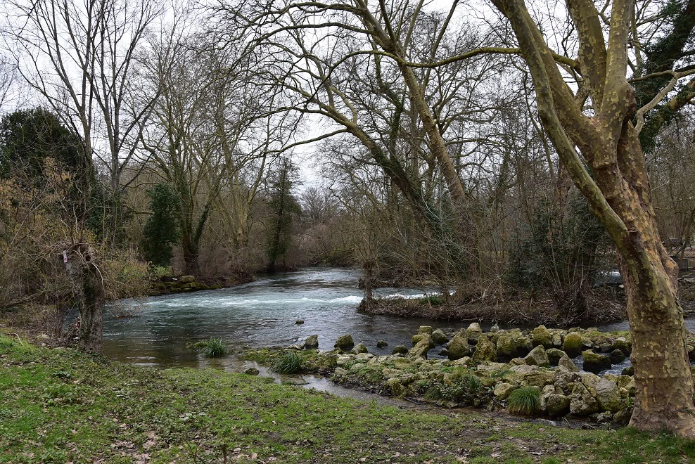
A view of the Sèvre Niortaise river with rapids and lush tree-lined banks in a late winter or early spring setting.
The Sèvre Niortaise river flowing through the wetland landscape of the reserve.

Galuchet Marsh and Sèvre Niortaise Meanders Regional Nature Reserve history and protected-area timeline

The Galuchet Marsh and Sèvre Niortaise Meanders Regional Nature Reserve was formally established on 16 June 2025 through a unanimous decision of the Conseil régional de Nouvelle-Aquitaine. Its designation as RNR341 followed recognition of the ecological richness of the wetland mosaic along the Sèvre Niortaise and its unique placement at the heart of the city of Niort. The reserve's creation positioned it as a pioneering example of urban nature conservation in the French regional nature reserve system.

Galuchet Marsh and Sèvre Niortaise Meanders Regional Nature Reserve landscape and geographic character

The reserve's landscape is shaped by the meanders of the Sèvre Niortaise, a coastal river that has carved a distinctive floodplain through the territory of Niort. The terrain combines low-lying wet meadows along the river bends with patches of wooded swamp vegetation and open marsh. Water dominates much of the visual character, whether through the river itself, the surrounding canals, or the seasonal inundations that define floodplain meadows.

This mosaic of landforms, watercourses, grasslands, and small wooded patches gives the site a layered scenery that is typical of the wetland landscapes found along the western French coastal rivers. The integration of cultivated fields into the mosaic also reflects the long-standing agricultural relationship with the floodplain.

Galuchet Marsh and Sèvre Niortaise Meanders Regional Nature Reserve ecosystems, habitats, and plant life

Ecologically, the reserve is defined by a mosaic of wetland habitats that combine to create exceptional biodiversity conditions. The site contains twelve habitats of community interest, four of which are priority habitats, a level of diversity that highlights the conservation value of the Sèvre Niortaise floodplain.

Five main habitat formations structure the reserve: wooded areas, paludal and marsh vegetation, dry grasslands, natural wet meadows, and the hydrological network of the river and its associated canals. Cultivated plots form a sixth component. About one third of the reserve consists of natural wet meadows, which provide both habitat continuity and a strong element of ecological identity within the protected area.

Galuchet Marsh and Sèvre Niortaise Meanders Regional Nature Reserve wildlife and species highlights

The wildlife of the reserve reflects its rich wetland habitat mosaic. Old ash trees with cavities present within the reserve provide key habitats for bats and for saproxylic insects, including the Alpine longhorn beetle (Rosalia alpina), a species associated with mature broadleaf woodland.

The open wetland landscape also supports a significant breeding colony of grey herons, which benefit from the combination of wooded nesting sites adjacent to rich feeding grounds. Beyond these highlights, the diversity of marsh, meadow, and aquatic habitats supports a broader community of wetland-associated fauna typical of the Sèvre Niortaise floodplain.

Galuchet Marsh and Sèvre Niortaise Meanders Regional Nature Reserve conservation status and protection priorities

The conservation importance of the reserve lies in the concentration of twelve community-interest habitats, including four priority habitats, within a relatively compact area along the Sèvre Niortaise. The wetland mosaic it protects is functionally linked to the river's hydrology, making the reserve an important site for safeguarding floodplain ecological processes in the region.

As the first urban regional nature reserve in France, the site also carries an institutional conservation significance. Its establishment demonstrates how meaningful habitat protection can be embedded within an urban setting, providing a working model for the integration of biodiversity conservation into densely populated areas along French waterways.

Top sights and standout views in Galuchet Marsh and Sèvre Niortaise Meanders Regional Nature Reserve

The reserve's strongest point of distinction is its status as France's first urban regional nature reserve, bringing formal ecological protection directly into the city of Niort along the Sèvre Niortaise. Combined with twelve community-interest habitats, four of them priority habitats, and a mosaic of meadows, marsh, woodland, and waterways, the reserve offers an unusually rich example of urban-adjacent wetland conservation.

Best time to visit Galuchet Marsh and Sèvre Niortaise Meanders Regional Nature Reserve

The wetland character of the reserve means that its visual and ecological appeal shifts through the seasons in line with water levels in the Sèvre Niortaise and its floodplain meadows. Late spring and early summer typically bring the most active birdlife, including the grey heron colony and other wetland-associated species, while wet meadows are most expressive after spring flooding. Winter and early spring can also be rewarding for observing waterbirds in the marsh and along the river.
Monthly climate preview

Long-term representative monthly temperature and precipitation patterns across the protected landscape

Climate Normals and Annual Temperature Rhythm for Réserve naturelle régionale du marais de Galuchet et des boucles de la Sèvre Niortaise

Measured historical records establish the representative temperature and precipitation rhythm across twelve distinct monthly cycles at the sampled coordinate. Examining the complete monthly profile provides deeper context regarding long-term climatic norms for this protected area.
Annual mean12 °C
5 °C20 °C
Jan
Feb
Mar
Apr11°
May14°
Jun18°
Jul20°
Aug20°
Sep17°
Oct13°
Nov
Dec
Warmest month
August

19.7 °C

Coolest month
January

4.8 °C

Wettest month
November

3 mm/day

Driest month
July

1.5 mm/day

Park location guide

Geography guide, regional context, and park location map for Galuchet Marsh and Sèvre Niortaise Meanders Regional Nature Reserve

Galuchet Marsh and Sèvre Niortaise Meanders Regional Nature Reserve park geography, regions, and map view in France

Understand where Galuchet Marsh and Sèvre Niortaise Meanders Regional Nature Reserve sits in France through a broader geographic reading of the surrounding landscape, nearby location context, and its mapped position within the national park landscape.

How Galuchet Marsh and Sèvre Niortaise Meanders Regional Nature Reserve fits into France

France is a unitary semi-presidential republic and one of the world's largest economies. It borders Belgium, Luxembourg, Germany, Switzerland, Italy, Monaco, Andorra, and Spain, with a maritime border to the United Kingdom. The country is known for its cultural influence, art, cuisine, and political history spanning centuries.

Wider geography shaping Galuchet Marsh and Sèvre Niortaise Meanders Regional Nature Reserve in France

France is located in Western Europe. Metropolitan France extends from the Rhine to the Atlantic Ocean and from the Mediterranean Sea to the English Channel and North Sea. The country borders Belgium, Luxembourg, Germany, Switzerland, Italy, Monaco, Andorra, Spain, and has a maritime border with the United Kingdom.

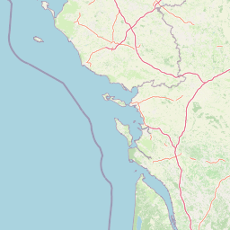
Map view of Galuchet Marsh and Sèvre Niortaise Meanders Regional Nature Reserve

Use this park location map to pinpoint Galuchet Marsh and Sèvre Niortaise Meanders Regional Nature Reserve in France, understand its exact geographic position, and read its mapped placement within the surrounding landscape more clearly.

Pigeon | © OpenStreetMap contributors

Location context for Galuchet Marsh and Sèvre Niortaise Meanders Regional Nature Reserve

Nouvelle-Aquitaine

Explore photographic records of wetland habitats, river meanders, and protected floodplain scenery.

Visualizing Réserve naturelle régionale du marais de Galuchet et des boucles de la Sèvre Niortaise Landscapes

Visual records reveal the diverse wetland habitats and river meanders that define Réserve naturelle régionale du marais de Galuchet et des boucles de la Sèvre Niortaise. Photographic documentation helps visitors examine the terrain, riparian woodland, and urban conservation character of this protected landscape.

A view of the Sèvre Niortaise river with rapids and lush tree-lined banks in a late winter or early spring setting.

Park atlas

Compare nearby protected wetlands and regional river valley landscapes in western France

Parks Near Réserve naturelle régionale du marais de Galuchet et des boucles de la Sèvre Niortaise

Browsing other protected areas near Réserve naturelle régionale du marais de Galuchet et des boucles de la Sèvre Niortaise reveals connected wetland corridors and river floodplain habitats. Comparing these regional landscapes deepens understanding of coastal river ecosystems across Nouvelle-Aquitaine.
Nature reserveDeux-Sèvres
About 23 km away#1 closest

Northeast

Réserve naturelle régionale du bocage des Antonins: Protected Landscape and Geographic Atlas

Detailed ecological mapping of the Gâtine armoricaine countryside

The Réserve naturelle régionale du bocage des Antonins occupies a distinct space in the Deux-Sèvres department. This protected area serves as a repository for the traditional bocage countryside, featuring a complex arrangement of pollarded trees, wet meadows, and the historic étang des Forges. The site offers a significant look at the structural history of rural western France through its preserved environmental matrix.

Area
0.226 km²
Established
2015
IUCN
IV
Relief
Lowland
Nature reservePays de la Loire
About 34 km away#2 closest

West

Réserve naturelle régionale du marais communal du Poiré-sur-Velluire Regional Nature Reserve

Mapping wetland biodiversity in the Pays de la Loire region

Spanning over 240 hectares of reclaimed marshland, this protected area stands as a unique ecological stronghold in France. The reserve demonstrates how traditional collective land management sustains a rich mosaic of freshwater and brackish habitats, supporting more than 177 bird species and heritage livestock breeds in an expansive, open terrain.

Area
2.41 km²
Established
2012
IUCN
IV
Scope
Terrestrial
Watercolor painting of a wetland landscape featuring grassy banks, calm water, and soft rolling hills in the background.
Nature reservePays de la Loire
About 47 km away#3 closest

West

Réserve naturelle régionale du marais de la Vacherie: Protected Wetland Geography and Maps

Ecological mosaic of the Marais poitevin in Pays de la Loire

The Réserve naturelle régionale du marais de la Vacherie protects a high-quality fragment of historical marshland. Defined by flat terrain, winter-flooded depressions, and a complex system of drainage channels, the site serves as a crucial habitat for rare wetland flora and migratory waterbirds. This protected landscape offers insight into the sediment-rich, gently undulating terrain that characterizes the back-marsh zones of the Atlantic seaboard.

Area
1.81 km²
Established
2008
IUCN
IV
Relief
Lowland
Nature reserveNouvelle-Aquitaine
About 48 km away#4 closest

South

Vallée de l'Antenne: A Protected River Valley and Alluvial Landscape in Nouvelle-Aquitaine

Mapping riparian ecosystems and rare wetland habitats

Trace the course of the Antenne river as it meanders through a finely textured mosaic of ash and alder forests, poplar plantations, and floodplains. As a designated Natura 2000 site, this nature reserve acts as a critical refuge for biodiversity in western France, offering a textbook example of a low-energy river system that descends gently through the landscape of the Charente departments.

Area
12.08 km²
Established
1999
Relief
Lowland
Climate
Mediterranean
Nature reservePays de la Loire
About 58 km away#5 closest

West

Réserve naturelle régionale de la ferme de Choisy: Marshland Protected Area and Regional Geography

Sub-brackish wet meadows of the Marais poitevin, Pays de la Loire.

Discover the unique ecological character of Réserve naturelle régionale de la ferme de Choisy, a vital wetland site in western France. This reserve showcases the intersection of traditional pastoral management and marshland conservation, hosting extensive bird populations and rare flora across its low-lying, reclaimed landscape.

Area
0.8 km²
Established
1991
IUCN
IV
Relief
Lowland
A horizontal watercolor painting depicting a winding river or lagoon flowing through rolling green hills and wetlands.
Nature reserveVendée
About 65 km away#6 closest

West

Réserve naturelle nationale de la casse de la Belle-Henriette: Geography and Protection

Coastal lagoon and dune habitat atlas in Vendée

Covering a narrow strip of the Atlantic coast, Réserve naturelle nationale de la casse de la Belle-Henriette protects essential marine lagoon and saltmarsh habitats. This data set explores the reserve's shifting dune morphology and its significance as a migratory bird corridor within the broader coastal geography of the Pays de la Loire region.

Area
3.37 km²
Established
2011
IUCN
IV
Relief
Lowland
Nature reserveNouvelle-Aquitaine
About 70 km away#7 closest

Southwest

Réserve naturelle régionale de la Massonne: Geographic Atlas and Protected Area Map

Mapped ecosystems within the Nouvelle-Aquitaine marshlands

Réserve naturelle régionale de la Massonne serves as a significant ecological corridor in western France, defined by its abrupt transition from coastal Brouage marshes to acidic heath. This atlas entry provides essential data on the reserve boundaries, mapped terrain types, and the structural diversity of its protected wetlands and shrublands, highlighting its role as a sanctuary for diverse nocturnal fauna.

Area
2.023 km²
Established
1997
IUCN
IV
Relief
Lowland
Nature reserveNouvelle-Aquitaine
About 75 km away#8 closest

North

Réserve naturelle régionale de la vallée du Pressoir: Protected Limestone Valley and Geoheritage

A rare natural and cultural mosaic in Nouvelle-Aquitaine

Trace the boundaries and natural features of the Réserve naturelle régionale de la vallée du Pressoir. This protected site in the Deux-Sèvres department is defined by thin calcareous soils, the historic Pommiers cascade, and fossil-rich limestone outcrops that form an unusual geoheritage landscape.

Area
0.56 km²
Established
2025
IUCN
IV
Visitors
10K annual

Common questions about visiting, size, designation, and location context for Galuchet Marsh and Sèvre Niortaise Meanders Regional Nature Reserve

Galuchet Marsh and Sèvre Niortaise Meanders Regional Nature Reserve FAQs for park facts, access, geography, and protected area context

Find quick answers about Galuchet Marsh and Sèvre Niortaise Meanders Regional Nature Reserve, including protected-area facts, park geography, trail and visitor context, and how the park fits into its surrounding country and regional landscape.
MoriAtlas Explorer

Continue Your Protected Areas Search Across the Global Atlas

Deepen your exploration by continuing the structured search for national parks and protected areas worldwide. Utilize the comprehensive filtering capabilities to compare different conservation landscapes and refine your understanding of global park geography. Discover more about the distribution and characteristics of protected natural areas.

Global natural geography