Mori Atlas logo
Wildlife reserveRock River Canyon Wilderness

Examining the natural forest succession and river-carved terrain of this distinct Upper Peninsula wilderness area.

Rock River Canyon Wilderness: A Detailed Geographic Atlas of a Protected Michigan Sandstone Canyon Landscape

Rock River Canyon Wilderness spans 4,640 acres of roadless forest within Michigan's Hiawatha National Forest. This protected area in Alger County features two distinct sandstone canyons carved by the Rock River and Silver Creek, standing as a significant example of unmanaged forest succession near Lake Superior. The terrain incorporates the notable Rock River Falls and Ginpole Lake, providing a sharp contrast to the surrounding timber-managed lands through its preserved, naturally evolving ecosystem.

wilderness areacanyonsandstone canyonUpper Peninsulanational forestHiawatha National Forest

Rock River Canyon Wilderness

Wildlife reserve

Park overview

Structured park overview, official facts, and landscape profile for Rock River Canyon Wilderness

Rock River Canyon Wilderness park facts, protected area profile, and essential visitor context

Review the core facts for Rock River Canyon Wilderness, including designation, size, terrain, visitor scale, habitats, and operating context in one park-focused overview.

About Rock River Canyon Wilderness

Rock River Canyon Wilderness is a small but ecologically meaningful protected area within the Hiawatha National Forest in Michigan's Upper Peninsula. The unit occupies about 4,640 acres of roadless land in Alger County, north of the small town of Chatham, and belongs to the federally protected National Wilderness Preservation System established by Congress in 1987.

At its heart, the wilderness is defined by water and stone. The Rock River and its tributary, Silver Creek, have carved two short but striking sandstone canyons roughly 150 feet deep. These shallow canyons, along with the 15-foot Rock River Falls and the modest 13-acre Ginpole Lake, give the unit a compact yet unusually varied landscape for its size. All of these features drain toward Lake Superior, tying the wilderness hydrologically to the great lake that shapes so much of the Upper Peninsula's identity.

The surrounding region saw intensive logging between roughly 1880 and 1930, followed by slash fires, erosion, and the slow return of a second-growth forest. Rock River Canyon Wilderness is unusual within the Hiawatha National Forest because it has not been returned to active timber management. Instead, it functions as a place where natural succession, wind, fire history, and wildlife can shape the land without ongoing harvest. That unmanaged character, combined with its canyon topography and Lake Superior-bound streams, gives the wilderness its distinctive identity: a quiet, steep-walled Upper Peninsula refuge embedded within a much larger, actively managed forest.

Quick facts and research context for Rock River Canyon Wilderness

Rock River Canyon Wilderness is a federally designated wilderness area of 4,640 acres, situated in the Hiawatha National Forest in Alger County, Michigan. It lies in the Upper Peninsula, just a few miles north of the small community of Chatham, and is reached by the M-94 corridor south of the unit.

The area was established by Congress in 1987 and is administered by the U.S. Forest Service under IUCN Category Ib wilderness protections. It forms part of the broader Lake Superior drainage basin through the Rock River, Silver Creek, Rock River Falls, and Ginpole Lake.

Protection and recognition

Terrestrial conservation scope and documented protected area framework

Rock River Canyon Wilderness Protection Status and International Recognition

Rock River Canyon Wilderness maintains a documented terrestrial protection scope within official conservation frameworks. Official records track administrative status and management designations for this protected landscape.

Protection details

Protection scope
Terrestrial
Transboundary protection
No
Park context

Deeper park guide and search-rich context for Rock River Canyon Wilderness

Rock River Canyon Wilderness history, landscape, wildlife, and travel context

Explore Rock River Canyon Wilderness through its history, landscape character, ecosystems, wildlife, conservation priorities, cultural context, and seasonal travel timing in a structured park guide built for atlas discovery and search intent.

Why Rock River Canyon Wilderness stands out

The wilderness is best known for its two narrow sandstone canyons, approximately 150 feet deep, where the Rock River and Silver Creek cut through crumbling Upper Peninsula bedrock. It is also recognized for Rock River Falls, the small Ginpole Lake, and the way it preserves an unmanaged, naturally regenerating forest within an otherwise working national forest landscape.

Rock River Canyon Wilderness history and protected-area timeline

Like much of the Hiawatha National Forest, the lands that now make up Rock River Canyon Wilderness were heavily logged beginning around 1880 and continuing through about 1930. The logging era was characterized by clear-cutting of marketable timber, with discarded slash left scattered across the forest floor. These conditions frequently triggered severe wildfires, which in turn led to substantial soil erosion.

The resulting second-growth forest differed in structure and species composition from the original old-growth forest that had covered the region for centuries. Across most of the Hiawatha National Forest, this second-growth landscape was again brought into timber production for pulpwood. Rock River Canyon Wilderness, however, was set aside from those working forest cycles.

In 1987, Congress formally designated the area as a wilderness under the National Wilderness Preservation System, establishing its present protected character. Since then, the unit has been managed by the U.S. Forest Service as a roadless wilderness where natural ecological processes are allowed to predominate, making it a living record of post-logging forest recovery in the Upper Peninsula.

Rock River Canyon Wilderness landscape and geographic character

The landscape of Rock River Canyon Wilderness is defined by two small but dramatic sandstone canyons, each cut roughly 150 feet into the surrounding terrain by flowing water. The Rock River and Silver Creek wind through these narrow, steep-walled corridors, creating one of the more distinctive small-scale canyon environments found anywhere in Michigan.

Rock climbing is not generally pursued here because the sandstone is friable and crumbly, meaning the cliff walls weather quickly and remain unstable. This softness also shapes the visual character of the canyons, which read as rounded, eroded channels rather than sharp alpine gorges.

Beyond the canyons, the wilderness includes the 15-foot Rock River Falls, a modest but scenic waterfall along the river's course. The shallow Ginpole Lake, covering about 13 acres, adds an open-water element to a unit otherwise dominated by forest and steep stream valleys. The entire landscape sits within the Lake Superior drainage basin, giving the terrain a cool, northwoods feel tied to the great lake just to the north.

Rock River Canyon Wilderness ecosystems, habitats, and plant life

Ecologically, Rock River Canyon Wilderness reflects what the Upper Peninsula looks like when nature is given room to recover from past logging without being pressed back into timber production. The current forests are predominantly second growth, shaped by cycles of clear-cutting, fire, erosion, and decades of regrowth following the late 19th and early 20th century logging era.

Because the unit has been left largely unmanaged compared to the surrounding national forest, it serves as an ecological template for natural succession. Wind disturbance, soil recovery, understory development, and gradual shifts in species composition can be observed here without the overlay of active forestry practices. This makes the wilderness valuable for understanding how northern hardwood and mixed forest communities re-establish themselves in the Great Lakes region.

The canyon's sandstone walls, shaded stream valleys, and small lake create a mosaic of microhabitats. Cooler, moister conditions along the river and around Ginpole Lake contrast with the drier, sun-exposed upper slopes and rim habitat.

Rock River Canyon Wilderness wildlife and species highlights

Large mammals are a visible part of the wilderness experience, with the American black bear moving through the canyon country and whitetail deer browsing in the surrounding forests. These two species are the most prominent large-fauna presences identified within the unit.

The Rock River and Silver Creek also support a surprisingly diverse cold-water fishery for a small area. Fish present in these waters include northern pike, coho salmon, brook trout, brown trout, and rainbow trout, drawn in part by the connection to the broader Lake Superior drainage system.

Beyond these headline species, the mix of mature second-growth forest, shady canyon walls, open water at Ginpole Lake, and riparian corridors along the Rock River provides habitat conditions typical of the Upper Peninsula, supporting migratory songbirds, small mammals, and a variety of forest-dependent species that benefit from the roadless, low-disturbance character of the landscape.

Rock River Canyon Wilderness conservation status and protection priorities

Rock River Canyon Wilderness plays a specific conservation role within the much larger Hiawatha National Forest. While most of the surrounding national forest lands are managed for timber production, the wilderness is a place where natural processes, including regeneration, wind, fire history, and wildlife-driven change, are allowed to operate without active harvest.

This makes the unit a useful benchmark for ecological comparison. Foresters and ecologists can study how an unmanaged Upper Peninsula forest differs from neighboring working forest lands, gaining insight into long-term recovery from past clear-cutting and repeated fires.

The protected status, established by Congress in 1987 and administered by the U.S. Forest Service under wilderness-area protections, also safeguards the canyon topography and Lake Superior tributary streams from road-building, logging, and other development that could otherwise fragment the corridor. In this way, it preserves both a local ecological reference site and a small but meaningful example of roadless Upper Peninsula wilderness.

Rock River Canyon Wilderness cultural meaning and human context

The cultural layer of Rock River Canyon Wilderness is most visible through the imprint of late 19th and early 20th century timber harvesting. The scars of the logging era, clear-cuts, slash fires, and subsequent erosion, are the defining human legacy of the landscape, and the second-growth forest that visitors see today is itself a product of industrial-era land use.

The surrounding Upper Peninsula region retains a strong identity tied to forestry, working forests, and small communities like Chatham that grew up alongside the resource industries. The wilderness contrasts with that identity by functioning as an unmanaged exception within a broader working-forest context, offering a quiet cultural statement about the value of letting land recover rather than continuously harvest it.

Top sights and standout views in Rock River Canyon Wilderness

The strongest single feature of Rock River Canyon Wilderness is the pair of roughly 150-foot sandstone canyons carved by the Rock River and Silver Creek, an unusual sight in Michigan. Add Rock River Falls, the compact Ginpole Lake, and the connection to the Lake Superior drainage, and the unit delivers a surprisingly varied landscape within a compact footprint.

Equally important, though less visually obvious, is the wilderness's role as an unmanaged, naturally recovering forest inside the larger Hiawatha National Forest. Visitors encounter not only canyon scenery but also a working demonstration of ecological succession in a region whose forests have otherwise been shaped by repeated cycles of cutting, fire, and regrowth.

Best time to visit Rock River Canyon Wilderness

The Upper Peninsula setting suggests that late spring through early fall is the most accessible window for visiting Rock River Canyon Wilderness, when snow has receded, the streams are fully open, and the second-growth forest is in active leaf-out. Summer brings the densest foliage, casting the narrow sandstone canyons into deep shade and producing the cooler, mossy conditions that define the river corridors.

Cooler temperatures near the Lake Superior drainage keep the area feeling distinctly northern even in midsummer. Early autumn brings color changes across the surrounding forest and lower water levels that make some streambed features easier to observe, while late autumn transitions the unit into a quieter, leaf-off period that opens up longer views into the canyon walls. Harsh winter conditions and heavy snowfall are typical but rarely inviting for casual recreation in this remote, roadless terrain.

Monthly climate preview

Long-term representative temperature ranges and precipitation patterns across twelve months

Rock River Canyon Wilderness Climate Normals and Monthly Weather Records

Representative point measurements for Rock River Canyon Wilderness show annual temperature variations alongside sustained monthly precipitation rates from historical records. Examining the complete twelve-month climatology reveals detailed shifts in average minimum and maximum temperatures across the protected landscape.
Annual mean5 °C
-6 °C18 °C
Jan-6°
Feb-6°
Mar-2°
Apr
May
Jun12°
Jul16°
Aug18°
Sep15°
Oct
Nov
Dec-3°
Warmest month
August

17.7 °C

Coolest month
January

-6.1 °C

Wettest month
October

3.4 mm/day

Driest month
February

1.6 mm/day

Park location guide

Geography guide, regional context, and park location map for Rock River Canyon Wilderness

Rock River Canyon Wilderness park geography, regions, and map view in United States of America

Understand where Rock River Canyon Wilderness sits in United States of America through a broader geographic reading of the surrounding landscape, nearby location context, and its mapped position within the national park landscape.

How Rock River Canyon Wilderness fits into United States of America

The United States of America is a federal presidential republic and one of the world's largest countries by area and population. It consists of 50 states across a vast territory spanning multiple time zones, with its capital in Washington, D.C. and largest city in New York City. The nation has a diverse economy, influential political system, and significant cultural and military presence globally.

Wider geography shaping Rock River Canyon Wilderness in United States of America

The United States occupies a vast territory in North America, bordered by Canada to the north and Mexico to the south. The 48 contiguous states stretch from the Atlantic to the Pacific Ocean, while Alaska occupies the northwestern region and Hawaii is an archipelago in the Pacific. The country encompasses diverse terrain including the Rocky Mountains, Appalachian Mountains, Great Plains, and extensive river systems.

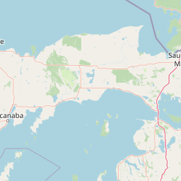
Map view of Rock River Canyon Wilderness

Use this park location map to pinpoint Rock River Canyon Wilderness in United States of America, understand its exact geographic position, and read its mapped placement within the surrounding landscape more clearly.

Pigeon | © OpenStreetMap contributors

Location context for Rock River Canyon Wilderness

Alger County
Park atlas

Compare regional geography, nearby national forests, and connected wilderness areas

Explore Parks Near Rock River Canyon Wilderness and Surrounding Protected Landscapes

Trace related protected areas across the surrounding region after exploring Rock River Canyon Wilderness. Compare northern forest ecosystems, river watersheds, and neighboring conservation lands in Michigan.
A watercolor painting of a rolling, soft-toned landscape with a foreground of green forest and layers of hills receding into the distance.
Protected landscapeUpper Peninsula of Michigan
Park boundaries overlap#1 closest

Southeast

Hiawatha National Forest: Geographic Overview and Protected Area Map of the Upper Peninsula

Coastal forest landscape and wilderness river corridors.

Hiawatha National Forest spans significant portions of the Upper Peninsula of Michigan, bridging the gap between northern hardwood forests and the boreal environments of the Great Lakes. This protected landscape encompasses extensive shorelines along Lake Superior, Lake Michigan, and Lake Huron, alongside six wilderness areas and five designated wild and scenic rivers.

Area
3,621.27 km²
Established
1931
IUCN
VI
Relief
Lowland
A watercolor painting showing a rolling landscape with green fields, sandy dunes, and a purple mountain range in the distance.
Natural monumentAlger County
About 50 km away#2 closest

East

Pictured Rocks National Lakeshore: Geographic Atlas of Cliffs and Shoreline Terrain

Protected landscape geography in Alger County, Michigan

Pictured Rocks National Lakeshore offers a deep look into the Great Lakes coastal geography. Explore the intersection of Cambrian-era sandstone cliffs, perched dune systems, and inland forested wilderness. This area provides a clear record of glacial and lake-driven erosion, featuring unique formations like Miners Castle and Chapel Rock across its extensive Lake Superior boundary.

Area
296.38 km²
Established
1966
IUCN
III
Visitors
953.1K annual
Wildlife reserveMichigan
78 km away#3 closest

West

McCormick Wilderness: Protected Forest and Hydrology in Michigan's Upper Peninsula

A federally protected wildlife reserve and river headwaters landscape

Centrally located within the western Upper Peninsula of Michigan, McCormick Wilderness preserves 17,000 acres of dense, regrown northern forest. The area is defined by its unusual density of river headwaters, providing significant ecological value as a quiet, roadless tract within the Ottawa National Forest network.

Area
69 km²
Established
1987
IUCN
Ib
Relief
Upland
A soft watercolor painting showing green rolling hills, a calm body of water, and small clusters of pink flowers against a light, hazy background.
National parkMichigan
151 km away#4 closest

South

Sleeping Bear Dunes National Lakeshore: Atlas, Maps, and Protected Landscape Geography

Great Lakes freshwater coast and glacial dune systems

Sleeping Bear Dunes National Lakeshore showcases the unique intersection of glacial geology and freshwater ecology. This protected area features massive dunes resting on ancient glacial deposits, backed by beech and maple forests. The geographic scope includes the vast shoreline of Lake Michigan, inland waters such as Glen Lake, and the distinct maritime history found across the remote North and South Manitou Islands.

Area
288.13 km²
Established
1970
IUCN
III
Visitors
1.5M annual
A pale, minimalist watercolor painting of a landscape with soft green hills, distant faded mountains, and a small, calm pool of water in the foreground.
Protected landscapeMichigan
About 152 km away#5 closest

West

Ottawa National Forest: Mapped Geography and Protected Landscape Context in Michigan

Glacial watersheds and waterfall corridors of the Upper Peninsula

Ottawa National Forest represents a primary protected landscape within the western Upper Peninsula of Michigan. This atlas entry covers its hydrological significance, ranging from Lake Superior tributaries to regional drainage divides, alongside its role in preserving old-growth white and red pine stands within a broader boreal forest mosaic.

Area
4,020 km²
Established
1931
IUCN
VI
Relief
Upland
Wildlife reserveMichigan
159 km away#6 closest

East

Mackinac Wilderness Protected Area: Glacial Terrain and River Geography in Upper Michigan

A roadless wilderness reserve within Hiawatha National Forest

Uncover the geographic significance of Mackinac Wilderness, an IUCN Category Ib protected area in Michigan. The unit provides a distinct look at northern forest recovery through a terrain of sandy ridges, aspen and birch cover, and aquatic corridors. This study examines the interplay between postglacial landforms and the ongoing natural succession occurring along the Carp River drainage basin.

Area
49.5 km²
IUCN
Ib
Relief
Lowland
Climate
Temperate
Wildlife reserveMichigan
174 km away#7 closest

East

Horseshoe Bay Wilderness: A Detailed Geographic Overview of Michigan Protected Lands

Protected wetland habitat and Lake Huron coastal geography

Horseshoe Bay Wilderness represents a pristine 3,787-acre protected area located along the northwestern corner of Lake Huron in Michigan. Administered as part of the Hiawatha National Forest, this wilderness features an intricate post-glacial landscape of riparian wetlands, dense northern whitecedar stands, and quiet shallow waters that serve as vital spawning ground for local aquatic life.

Area
15.33 km²
Established
1987
IUCN
Ib
Relief
Lowland
A watercolor painting showing a winding river flowing through a lush, green valley with rolling mountains in the distance.
Wildlife reserveUnited States of America
About 189 km away#8 closest

East

Round Island Wilderness: Geographic Overview of the Straits of Mackinac Wildlife Reserve

Coastal marsh, conifer forest, and hardwood interior terrain

Round Island Wilderness encompasses nearly all of a 378-acre island sanctuary, distinguished by its mature beech-maple hardwood interior and boreal-leaning conifer forests. This protected land remains an essential study of Great Lakes island ecology, standing as a quiet, undisturbed wilderness edge along the transit routes of the Michigan straits.

Area
1.53 km²
Relief
Lowland
Climate
Temperate
Access
Remote access

Common questions about visiting, size, designation, and location context for Rock River Canyon Wilderness

Rock River Canyon Wilderness FAQs for park facts, access, geography, and protected area context

Find quick answers about Rock River Canyon Wilderness, including protected-area facts, park geography, trail and visitor context, and how the park fits into its surrounding country and regional landscape.
MoriAtlas Explorer

Continue Your Protected Areas Search Across the Global Atlas

Deepen your exploration by continuing the structured search for national parks and protected areas worldwide. Utilize the comprehensive filtering capabilities to compare different conservation landscapes and refine your understanding of global park geography. Discover more about the distribution and characteristics of protected natural areas.

Global natural geography