
Mori Atlas logo
Natural monumentRybenské Perničky

Examining the orthogneiss rock outcrops and weathering basins in the Pardubice Region of the Czech Republic

Rybenské Perničky: A Geological Natural Monument within the Bohemian-Moravian Highlands Landscape

(Přírodní památka Rybenské Perničky)

Rybenské Perničky stands as a distinctive geological landmark within the Pardubice Region, preserving a pair of prominent orthogneiss rock outcrops that define this upland territory. The protected site showcases rare bowl-shaped weathering cavities, or perničky, which contrast sharply with the surrounding rolling plateau landscape of the Bohemian-Moravian Highlands. This atlas entry provides geographic context for these ancient crystalline formations, detailing their physical structure and their significance as a protected natural monument situated near the broader Žďárské vrchy landscape.

geological monumentgneiss outcropsweathering featuresrock formationsBohemian-Moravian HighlandsPardubice Region
A flat-style digital illustration showing a light-colored, rocky outcrop framed by stylized evergreen trees, with a small waterfall flowing at the base of the rocks.

Rybenské Perničky

Natural monument

Park overview

Structured park overview, official facts, and landscape profile for Rybenské Perničky

Rybenské Perničky park facts, protected area profile, and essential visitor context

Review the core facts for Rybenské Perničky, including designation, size, terrain, visitor scale, habitats, and operating context in one park-focused overview.

About Rybenské Perničky

Rybenské Perničky is a compact natural monument in the eastern part of the Bohemian-Moravian Highlands, situated in the forested uplands west of the village of Pustá Rybná. Although small in size, it captures one of the more distinctive small-scale geological scenes in the Czech countryside: two isolated blocks of orthogneiss rising modestly above the surrounding terrain, both sculpted over long periods into shapes unlike the ordinary fractured bedrock typical of the region.

The rocks serve as the central and almost the sole focus of the protected territory. They sit within a broader landscape shaped by ancient crystalline basement rocks of the Moldanubian and Moravian units, expressed here as low, rounded hills and broad plateaus crossed by quiet rural roads and farmland. The Žďárské vrchy Protected Landscape Area lies nearby, and administration of the site falls under that protected landscape's regional office, anchoring Rybenské Perničky within a wider network of conservation areas focused on the uplands of the Czech-Moravian border region.

The geological story of the site is what gives it its identity. The orthogneiss from which the rocks are formed is a metamorphic rock originating deep in the crust, later uplifted and exposed. Once at the surface, it became subject to weathering processes that, rather than uniformly rounding the outcrops, carved distinctive basin-shaped depressions into the rock surfaces. These hollows, smoothed and deepened over time, are the 'perničky' referenced in the name. The largest of them reach widths of around sixty centimeters and depths of around twenty centimeters, large enough to be unmistakable features of the rock tops and small enough to remain visually appealing rather than disruptive.

As a place to experience, Rybenské Perničky is modest but rewarding. The rocks offer short, scenic walks from the surrounding countryside; the second half of the year allows rock climbing on the outcrops; and the broader setting of the Žďárské vrchy uplands offers a quiet backdrop of forest, fields, and traditional Czech rural landscape. It is the type of site whose significance becomes clear through close observation rather than dramatic scale.

Quick facts and research context for Rybenské Perničky

Rybenské Perničky is a Czech natural monument (přírodní památka) covering roughly 14 hectares near Pustá Rybná in the Svitavy District of the Pardubice Region. It lies at elevations between approximately 730 and 748 meters above sea level.

The area protects a pair of orthogneiss rock blocks, reaching heights of around 8 and 16 meters, that are notable for their basin-shaped weathering hollows. The protected area was established in November 1980 and is administered through the Žďárské vrchy Protected Landscape Area administration of the Czech Agency for Nature Conservation and Landscape Protection (AOPK ČR). Climbing is permitted on the rocks during the second half of the year.

Protection and recognition

Explore documented terrestrial protection scope and conservation status details

Rybenské Perničky Protection Status and International Recognition Facts

Rybenské Perničky maintains a documented terrestrial protection scope within the regional conservation network. Structured facts outline the recorded designation framework and international recognition data for this protected landscape.

Protection details

Protection scope
Terrestrial
Transboundary protection
No
Park context

Deeper park guide and search-rich context for Rybenské Perničky

Rybenské Perničky history, landscape, wildlife, and travel context

Explore Rybenské Perničky through its history, landscape character, ecosystems, wildlife, conservation priorities, cultural context, and seasonal travel timing in a structured park guide built for atlas discovery and search intent.

Why Rybenské Perničky stands out

Rybenské Perničky is best known for its pair of orthogneiss rock outcrops displaying unusually well-developed bowl-shaped weathering cavities, the very feature that gave the site its name. These 'perničky', round depressions worn into the upper surfaces of the gneiss blocks, are the defining geological curiosity that justifies the area's protected status. Beyond the rocks themselves, the site is appreciated as a small but characteristic example of upland rock landscape within the broader Žďárské vrchy region, where gneiss and granite landforms dot the rolling plateau. The contrast between the smooth, sculpted weathering basins and the otherwise angular, fractured gneiss outcrops gives the place a distinctive visual personality that draws both geologically curious visitors and rock climbers.
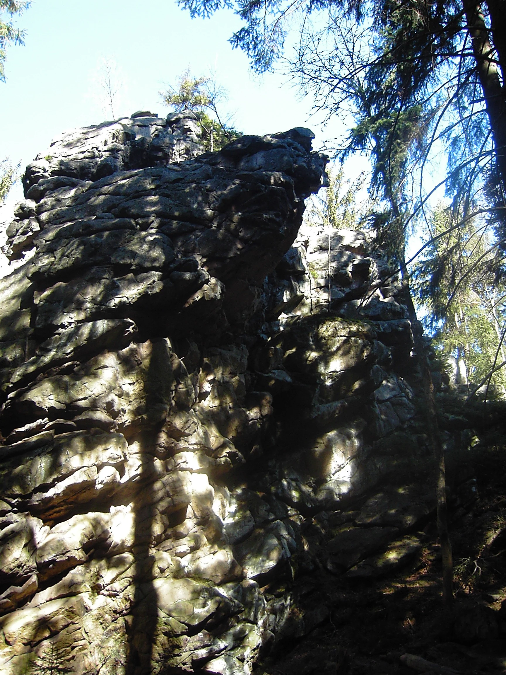
Large, dark, weathered rock outcrops surrounded by tall evergreen trees in a forested area.
Weathered rock formations at Rybenské Perničky.

Rybenské Perničky history and protected-area timeline

Rybenské Perničky was formally declared a protected natural monument on 20 November 1980 by the District National Committee in Svitavy, in what was then still the late socialist-era administrative structure of Czechoslovakia. Its designation as a přírodní památka reflected the prevailing approach of protecting not only biologically rich areas but also smaller geological and geomorphological features of scientific and aesthetic value.

The rocks themselves, however, are far older than any administrative history. They formed as orthogneiss during ancient tectonic and metamorphic processes, were gradually exposed at the surface through uplift and erosion, and acquired their distinctive basin-shaped weathering features over prolonged periods of physical and chemical weathering. Thus, while the legal protection of the site is a product of late twentieth-century conservation thinking, the landscape feature being protected is the result of processes operating across geologic time.

Since its establishment, the site has been administered as part of the broader Žďárské vrchy Protected Landscape Area framework through the Czech Agency for Nature Conservation and Landscape Protection (AOPK ČR). Its protected status has ensured that its geological character remains undisturbed and that climbing access is regulated to balance recreational use with conservation of the rock surfaces and their weathering hollows.

Rybenské Perničky landscape and geographic character

The landscape at Rybenské Perničky is shaped by the gentle, rolling character of the Czech-Moravian uplands, where ancient crystalline rocks of the Bohemian Massif have been worn over geologic time into subdued hills, broad plateaus, and shallow valleys. Elevation at the site runs from roughly 730 to 748 meters above sea level, placing it within the transitional zone between true mountains and low plateaus typical of this part of the country.

At the heart of the protected area are two separate rock blocks of orthogneiss, rising as isolated outcrops from the surrounding terrain. The smaller block reaches about 8 meters in height while the larger one climbs to roughly 16 meters, both standing as compact but visually distinct landmarks. Their surfaces display the characteristic gneissic texture of alternating light and dark mineral bands, broken by fractures and partly covered with lichen and moss.

The more dramatic landscape feature, however, is not the height of the rocks but the weathering basins carved into their upper surfaces. These bowl-shaped depressions, the perničky, vary in size and depth but are markedly smooth and rounded compared to the angular gneiss around them, giving the rock tops an almost sculpted, organic quality. Their formation reflects long-term exposure to rainwater, freeze-thaw processes, and chemical weathering acting on a rock type unusually susceptible to such sculpting.
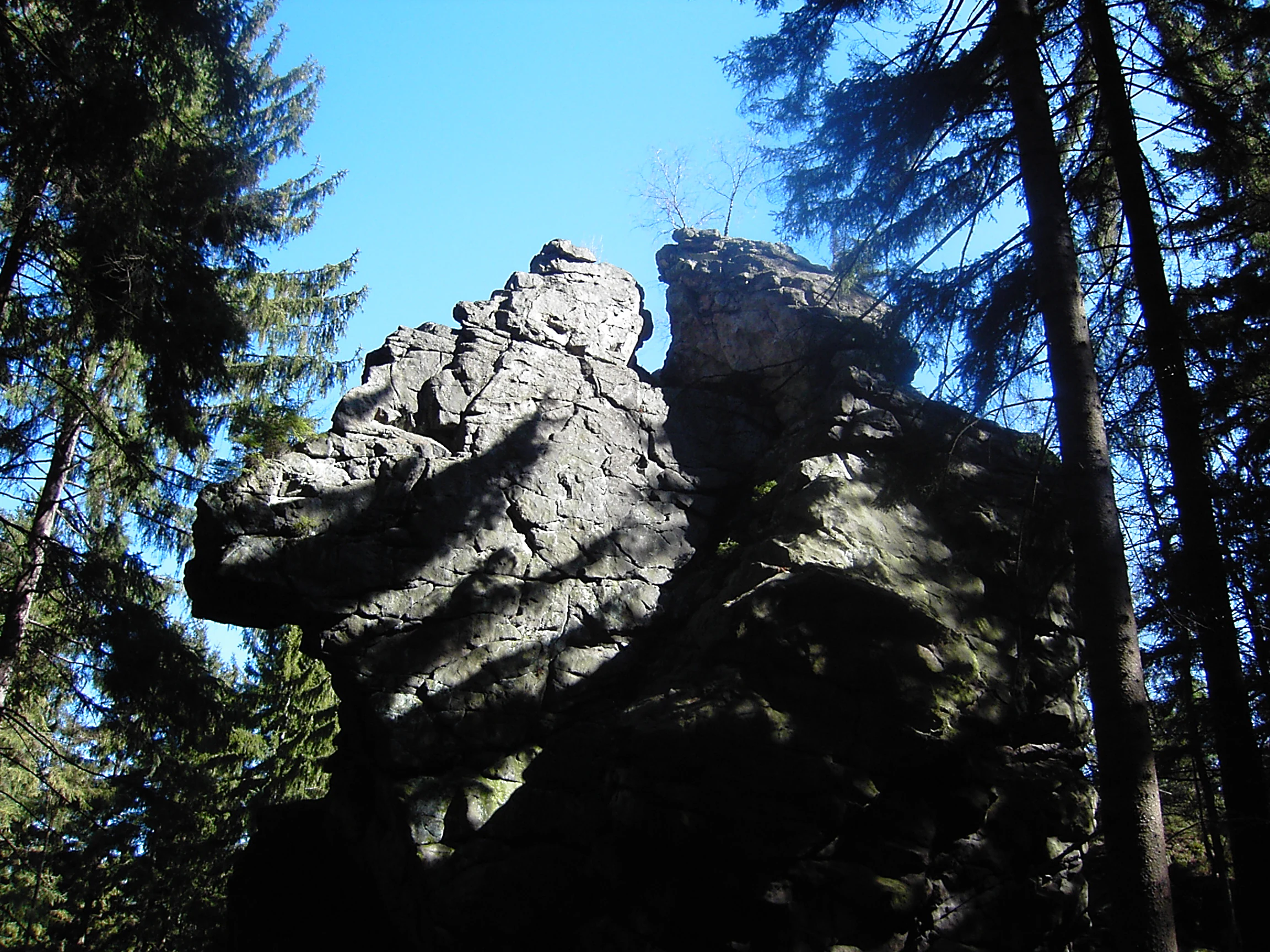
A large, weathered sandstone rock formation rising above a surrounding forest with clear blue sky visible in the background.
Sandstone rock formations at Rybenské Perničky.

Rybenské Perničky ecosystems, habitats, and plant life

Ecologically, Rybenské Perničky is a relatively small and modest site whose nature is inseparable from its geology. The protected territory is dominated by the rock outcrops themselves and the immediate surroundings of mixed upland forest, rough grassland, and edge habitats where rocky ground meets vegetated slopes. This is consistent with the broader biogeographic character of the Žďárské vrchy region, where crystalline bedrock, acidic soils, and a colder, wetter upland climate create conditions favorable for coniferous and mixed forests, bilberry-dominated undergrowth, and acid-tolerant herb communities.

Because the protection rationale is geological rather than biological, the site's contribution to nature conservation lies more in preserving a particular landform and its associated microhabitats than in protecting any specific rare community. The crevices, ledges, and shaded overhangs of the gneiss outcrops nonetheless harbor small but characteristic assemblages of rock-dwelling lichens, mosses, and invertebrates, while the transition zones between rock and forest support typical upland woodland species of the Bohemian-Moravian Highlands.

In broader ecological context, Rybenské Perničky can be read as a small, representative component of the larger mosaic of forest, rock, and meadow habitats that the Žďárské vrchy Protected Landscape Area was established to maintain. Its conservation value is therefore both intrinsic, as a preserved geomorphological feature, and contextual, as a contribution to habitat diversity within the surrounding protected landscape.
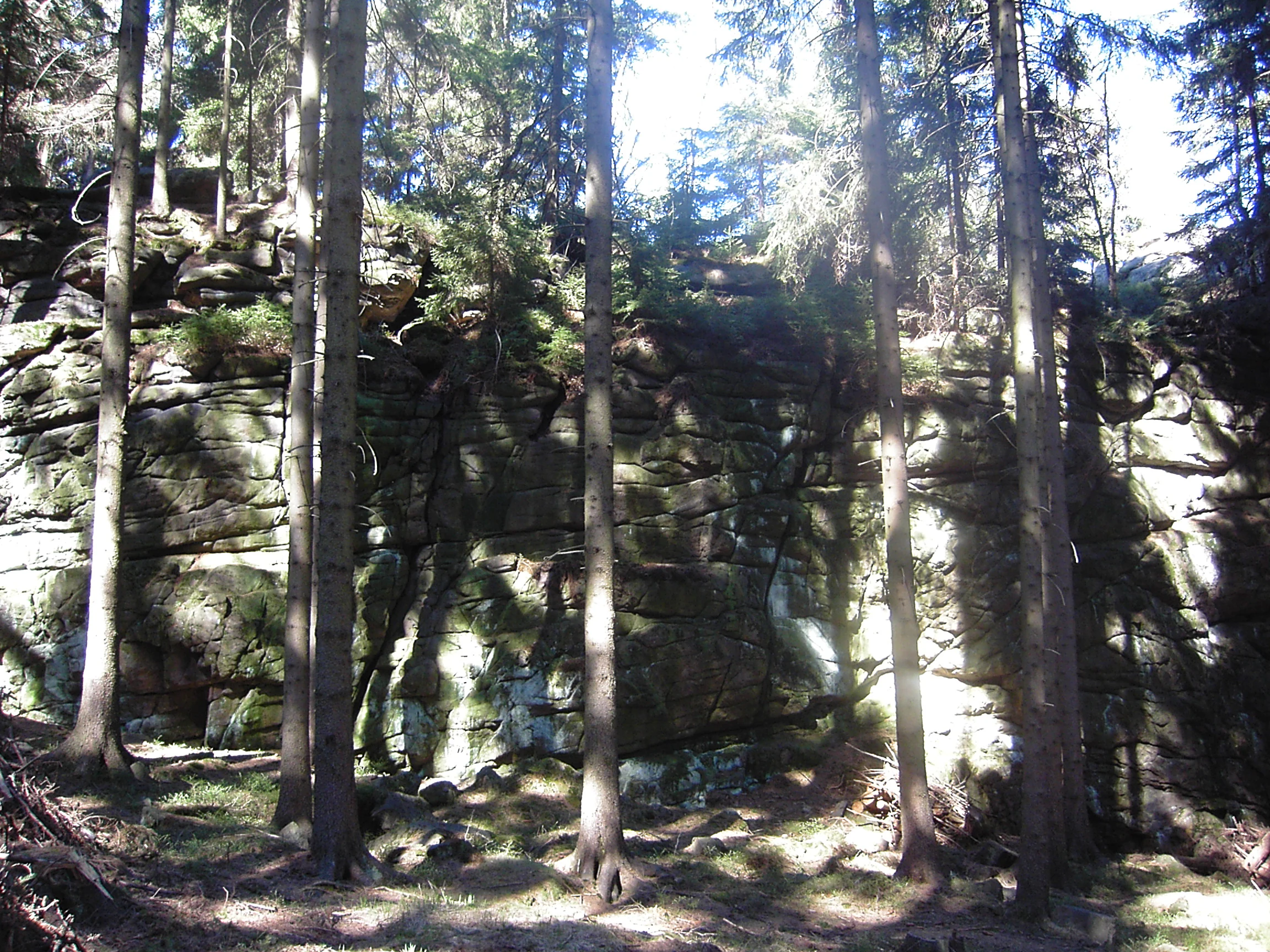
A rock cliff face featuring horizontal layering and weathered textures, surrounded by a dense forest of evergreen trees.
Weathered rock formations at the Rybenské Perničky natural monument.

Rybenské Perničky conservation status and protection priorities

The conservation significance of Rybenské Perničky centers on the protection of a specific and scientifically valuable geological formation rather than on broad-scale habitat preservation. As a přírodní památka, the site's designation reflects a deliberate effort to safeguard an example of weathering landform development in orthogneiss that is considered regionally distinctive and scientifically instructive for understanding the long-term evolution of the Bohemian Massif's surface.

Within the wider Czech system of protected areas, the site is administratively integrated into the Žďárské vrchy Protected Landscape Area framework and managed through AOPK ČR, the national nature conservation agency. This embedding within a larger protected landscape gives the small monument a stronger conservation context: its protection fits into a regional strategy of preserving geological heritage, traditional land use, and upland ecological character across the Czech-Moravian borderlands.

Practical conservation management focuses on keeping the rock surfaces and their weathering basins intact, controlling access, and regulating rock climbing to a defined seasonal window in the second half of the year. By limiting disturbance to the rock surfaces and the surrounding microhabitats, the management approach aims to ensure that the geological features that justified the site's protection remain visible and unaltered for future study and appreciation.

Rybenské Perničky cultural meaning and human context

The cultural dimension of Rybenské Perničky is rooted in the rural Czech landscape heritage of the Bohemian-Moravian Highlands and in the folk linguistic tradition that named the rocks. The term perničky, applied to the bowl-shaped weathering hollows on the rock tops, derives from the older Czech word pernice, a basin used historically for finely grinding cooked poppy seeds with a pestle.

This etymological link reflects a broader tradition in which rural communities across the Bohemian-Moravian uplands observed and named unusual natural features using the vocabulary of everyday domestic life. The naming testifies to a long-standing local familiarity with the rocks and suggests that the weathering basins were distinctive enough to have entered folk vocabulary well before any formal conservation designation existed. Today, the site sits within a landscape of small villages, traditional agricultural land use, and a network of protected areas that together reflect the region's enduring identity as a meeting point between nature conservation and rural Czech heritage.

Top sights and standout views in Rybenské Perničky

The principal highlight of Rybenské Perničky is the pair of orthogneiss outcrops themselves, which together form one of the cleaner small-scale geological landmarks of the Žďárské vrchy region. Their combination of compact height, isolated setting, and exceptionally well-developed weathering basins makes them both scientifically notable and visually appealing.

Equally worth noting is the site's role within the broader Žďárské vrchy Protected Landscape Area, giving visitors the chance to experience a quiet corner of the Bohemian-Moravian Highlands where ancient crystalline rocks, upland forest, and traditional rural landscapes meet. The seasonal availability of rock climbing adds a recreational dimension that, combined with the site's geological significance, makes Rybenské Perničky a small but well-rounded destination for visitors interested in geology, light outdoor activity, and the characteristic atmosphere of the Czech-Moravian uplands.

Best time to visit Rybenské Perničky

Because Rybenské Perničky is a small geological monument set within an upland forested landscape, the experience of visiting changes meaningfully with the seasons. Late spring and summer offer the most accessible walking conditions, with green vegetation, mild weather, and clear views of the rock surfaces and their weathering hollows; this is also the period when the surrounding Žďárské vrchy landscape is at its most visually vibrant for general countryside walking and nature observation.

Autumn transforms the surrounding forests into a tapestry of seasonal color, providing a particularly atmospheric setting for viewing the rocks against a backdrop of russet and gold foliage, while winter brings a quieter, more austere atmosphere in which the gneiss outcrops stand out starkly against snow-dusted terrain, though access can become more challenging.

Rock climbers specifically will find the second half of the year the relevant visiting window, as climbing activity is regulated to that seasonal period, a regulation that supports the broader aim of minimizing disturbance to nesting and breeding wildlife and to the rock surfaces themselves.

Monthly climate preview

Long-term representative point measurements tracking monthly temperature ranges and precipitation patterns

Rybenské Perničky Climate Normals, Annual Temperature and Precipitation Rhythm

Rybenské Perničky records measured long-term averages spanning sub-zero winter minimums and warm summer maximums alongside consistent monthly precipitation rates. Analyzing the complete twelve-month climate profile reveals precise seasonal shifts in temperature and moisture across the protected coordinate.
Annual mean7 °C
-4 °C18 °C
Jan-4°
Feb-2°
Mar
Apr
May12°
Jun16°
Jul18°
Aug18°
Sep13°
Oct
Nov
Dec-3°
Warmest month
July

18.5 °C

Coolest month
January

-3.8 °C

Wettest month
July

2.8 mm/day

Driest month
February

1.2 mm/day

Park location guide

Geography guide, regional context, and park location map for Rybenské Perničky

Rybenské Perničky park geography, regions, and map view in Czechia

Understand where Rybenské Perničky sits in Czechia through a broader geographic reading of the surrounding landscape, nearby location context, and its mapped position within the national park landscape.

How Rybenské Perničky fits into Czechia

Czech Republic is a landlocked Central European country with a population of approximately 10.9 million people. The nation was established as an independent state on January 1, 1993, following the dissolution of Czechoslovakia. Its capital and largest city is Prague, with other major urban centers including Brno, Ostrava, Plzeň, and Liberec.

Wider geography shaping Rybenské Perničky in Czechia

The Czech Republic is a landlocked country in Central Europe. It is bordered by Germany to the west, Austria to the south, Poland to the northeast, and Slovakia to the southeast. The landscape is predominantly hilly, with the territory covering 78,871 square kilometers.

Map view of Rybenské Perničky

Use this park location map to pinpoint Rybenské Perničky in Czechia, understand its exact geographic position, and read its mapped placement within the surrounding landscape more clearly.

Pigeon | © OpenStreetMap contributors

Location context for Rybenské Perničky

Pardubický kraj

Explore detailed imagery of weathering features and the upland protected environment

Rybenské Perničky Photos and Landscapes, Visualizing Gneiss Rock Outcrops

Visual records capture the distinctive orthogneiss formations and sculpted weathering basins that define Rybenské Perničky within the Bohemian-Moravian Highlands. Examining photographic documentation helps researchers and visitors analyze the geological terrain and protected landscape character without traveling to the site.

Large, dark, weathered rock outcrops surrounded by tall evergreen trees in a forested area.

A low-angle view of large, mossy rock formations partially shaded by tall conifer trees in a forest setting.

A large, weathered sandstone rock formation rising above a surrounding forest with clear blue sky visible in the background.

A rock cliff face featuring horizontal layering and weathered textures, surrounded by a dense forest of evergreen trees.

Park atlas

Compare nearby geological monuments and connected regional protected landscapes

Explore Parks Near Rybenské Perničky and Protected Areas in the Surrounding Uplands

Browse other parks near Rybenské Perničky to examine similar gneiss formations across the Bohemian-Moravian Highlands. Comparing adjacent protected areas reveals the broader geological patterns shaping regional upland terrain.
A horizontal watercolor painting depicting a soft, scenic view of hills with rocky outcrops in the foreground and a forested landscape in the distance.
Protected areaCzechia
About 6.4 km away#1 closest

Southwest

Malinská skála: Geomorphological Landmark and Viewpoint in the Czech-Moravian Highlands

Protected gneiss rock group and mountain ridge geography

Rising as a striking summit in the Žďárské vrchy, Malinská skála presents a concentrated group of named gneiss towers reaching 20 meters in height. The site functions as a geological monument, preserving classic examples of frost-shattered boulder streams and high-elevation landforms. With its panoramic vantage points, it serves as a central point for mapping the topography of the surrounding Czech upland ridges.

Area
0.058 km²
Established
1987
Relief
Mountain
Climate
Temperate
Natural monumentKraj Vysočina
About 14 km away#2 closest

South

Vávrova skála Natural Monument: Geological Exploration in the Kraj Vysočina Region

Metamorphic rock outcrops and highland protected habitats

Vávrova skála stands as a protected natural monument near Pohledec, showcasing a distinct orthogneiss formation shaped by Quaternary weathering. This site serves as a vital reference for the geological diversity of the Bohemian-Moravian highlands, protecting rare summit heath and dry grassland within the larger Žďárské vrchy protected landscape.

Area
0.001 km²
Established
1983
IUCN
III
Relief
Upland
A watercolor painting showing a soft landscape of rolling hills, grassy meadows, and patches of vegetation in a pastel color palette.
Natural monumentKraj Vysočina
About 14 km away#3 closest

Southwest

Sklenské louky Natural Monument: Wetland Landscapes in Kraj Vysočina

Highland geography and protected peatland habitats

Sklenské louky functions as a concentrated nature monument within the Kraj Vysočina region, preserving vital moisture-loving vegetation and peat-based ecosystems. The terrain features a characteristic mix of open meadows and spruce groupings, illustrating the diverse landscape character of the Bohemian-Moravian Highlands. This protected area provides a clear view into the region's unique upland hydrological and botanical patterns.

Area
0.063 km²
Established
1985
IUCN
IV
Relief
Upland
A soft watercolor painting showing a quiet pond landscape with grassy banks, reeds, and distant trees against a pale background.
Nature reservePardubický kraj
About 14 km away#4 closest

Northwest

Ratajské rybníky Protected Nature Reserve: Highland Wetland Geography and Mapped Boundaries

A core wetland refuge for rare flora and fauna in the Pardubický kraj region

The Ratajské rybníky reserve represents a vital highland wetland ecosystem characterized by its three connected fishponds and surrounding quaking bogs. This mapped protected area provides an essential habitat for endangered butterfly populations, the rare moss Hamatocaulis vernicosus, and dense amphibian breeding grounds, set against the backdrop of the forested Železné hory mountain ridge.

Established
1990
IUCN
IV
Relief
Upland
Climate
Temperate
A watercolor painting of a soft, rolling landscape with green hills, patches of trees, and a pale sky.
Natural monumentPardubický kraj
About 15 km away#5 closest

East

Sněženky ve Vysokém lese: Exploring the Protected Natural Monument and Forest Geography

A small-scale Bohemian botanical reserve and valley landscape

Located in the Svitavy district of Pardubický kraj, Sněženky ve Vysokém lese is a natural monument dedicated to preserving a dense, naturally occurring population of wild snowdrops. The protected hollow, carved into the broader Vysoký les spruce woodland, illustrates how specific moisture conditions and soil patterns create essential habitats for rare local wildflowers within the Czech landscape.

Area
0.022 km²
Established
1994
IUCN
IV
Relief
Upland
A soft, horizontal watercolor painting showing a green meadow in the foreground leading to a line of trees and distant rolling hills.
Natural monumentKraj Vysočina
About 19 km away#6 closest

Southeast

Na Ostrážné Natural Monument: Geographic Boundaries and Protected Meadow Landscapes

A vital Natura 2000 site in the Bohemian-Moravian Highlands

The Na Ostrážné natural monument encompasses a compact meadow ecosystem situated on an ecologically expressive slope. This area serves as a critical refuge for rare invertebrate species, maintaining traditional grassland characteristics within the Svratecká hornatina. Its status as both a national monument and a European site makes it a key focus for understanding habitat preservation in the Vysočina Region.

Area
0.014 km²
Established
2015
IUCN
IV
Relief
Upland
A soft watercolor painting of a serene landscape featuring a calm lake surrounded by trees and gentle rolling hills in the background.
Natural monumentKraj Vysočina
About 23 km away#7 closest

Southwest

Rozštípená skála Natural Monument: Geological Mapping of the Vysočina Gneiss Outcrops

Protected rocky terrain in the Bohemian-Moravian Highlands

Rozštípená skála features a striking gneiss cliff formation split by long weathered fissures. Located in the Vysočina Region, this natural monument provides a focal point for understanding the geological patterns and river valley landscapes that define the mid-altitude terrain of the Czech Republic.

Area
0.008 km²
Established
1974
IUCN
III
Relief
Upland
Nature reserveKraj Vysočina
About 24 km away#8 closest

Southeast

Pyšolec Nature Reserve: Protected Forest Geography and Mapped Terrain in Kraj Vysočina

Biodiverse woodland and historic castle ruin protected area

Pyšolec is a significant nature reserve characterized by mature broadleaf forests and steep, rocky terrain in the Czech Vysočina Region. The site provides a critical habitat for specialized invertebrates and rare species within its unique forest-castle mosaic, mapped here for geographic context and ecological study.

Area
0.342 km²
Established
2021
IUCN
IV
Relief
Upland

Common questions about visiting, size, designation, and location context for Rybenské Perničky

Rybenské Perničky FAQs for park facts, access, geography, and protected area context

Find quick answers about Rybenské Perničky, including protected-area facts, park geography, trail and visitor context, and how the park fits into its surrounding country and regional landscape.
MoriAtlas Explorer

Continue Your Protected Areas Search Across the Global Atlas

Deepen your exploration by continuing the structured search for national parks and protected areas worldwide. Utilize the comprehensive filtering capabilities to compare different conservation landscapes and refine your understanding of global park geography. Discover more about the distribution and characteristics of protected natural areas.

Global natural geography