Mori Atlas logo
National parkSalim Ali National Park

Discover the mapped boundaries and geographic context of this national park.

Salim Ali National Park: National Park Protected Landscape in Jammu and Kashmir

Salim Ali National Park represents a significant protected landscape within the union territory of Jammu and Kashmir. As a designated national park, it offers a focused lens for understanding protected areas and their geographic distribution. This entry serves as a gateway to exploring the park's mapped boundaries, its regional context within Jammu and Kashmir, and its role as a distinct natural territory within India's atlas of conservation lands.

Himalayan forestsKashmir valleyFormer national parkEndangered species habitatBirdwatchingTemperate forest

Salim Ali National Park

National park

Park overview

Structured park overview, official facts, and landscape profile for Salim Ali National Park

Salim Ali National Park park facts, protected area profile, and essential visitor context

Review the core facts for Salim Ali National Park, including designation, size, terrain, visitor scale, habitats, and operating context in one park-focused overview.

About Salim Ali National Park

Salim Ali National Park represented an effort to preserve a portion of the Kashmir valley's natural environment within proximity to Srinagar, the region's largest city. The park was situated in an area characterized by temperate forest vegetation typical of the western Himalayas, with mixed coniferous and deciduous tree cover, open meadows, and associated wetland areas. The establishment of the protected area in 1986 reflected a broader movement in India during the late 20th century to designate significant natural sites as national parks, providing formal legal protection to ecosystems and wildlife populations. The park's naming after Salim Ali, whose pioneering work in popularizing birdwatching and ornithological study in India spanned much of the 20th century, underscored the cultural and scientific importance attached to the site. The transformation of the park into a golf course in the years following its establishment marked a controversial shift in land use, raising questions about the trade-offs between development pressures and conservation priorities in the Kashmir region.

Quick facts and research context for Salim Ali National Park

Salim Ali National Park occupied roughly 9 square kilometers in the Srinagar metropolitan area of Jammu and Kashmir union territory in northern India. The park was formally notified in 1986 as a Category II protected area under IUCN classifications. It was named after Dr. Salim Ali (1896–1987), whose influential work in Indian ornithology brought widespread attention to bird conservation across the subcontinent. The park contained diverse Himalayan fauna including the hangul (Kashmiri stag), musk deer, Himalayan black bear, leopard, and Himalayan serow. Bird diversity was notable, with approximately 70 species recorded including the paradise flycatcher, Himalayan monal, and Himalayan snowcock. The conversion of the park into a golf course between 1998 and 2001 marked a significant transformation of the site's conservation status.

Protection and recognition

Tracking documented terrestrial protection parameters and conservation frameworks

Protection Status and Environmental Designation of Salim Ali National Park

Public records define the terrestrial protection status and environmental boundaries of Salim Ali National Park to support regional conservation mapping. Accessing official designation frameworks and verified datasets provides essential geographic context for evaluating the legal management scope of the park.

Protection details

Protection scope
Terrestrial
Park context

Deeper park guide and search-rich context for Salim Ali National Park

Salim Ali National Park history, landscape, wildlife, and travel context

Explore Salim Ali National Park through its history, landscape character, ecosystems, wildlife, conservation priorities, cultural context, and seasonal travel timing in a structured park guide built for atlas discovery and search intent.

Why Salim Ali National Park stands out

Salim Ali National Park was particularly known for its association with one of India's most influential naturalists and for protecting a representative sample of Kashmir valley forest ecosystems. The park served as an important habitat for several threatened Himalayan species, most notably the hangul (Cervus hangul), a distinctive subspecies of red deer endemic to the Kashmir region. Its bird fauna included visually striking species such as the Himalayan monal, a vibrantly colored pheasant, and the elegant paradise flycatcher with its long tail plumes. The park's location near Srinagar made it one of the few protected areas accessible from a major urban center in the Kashmir valley, offering residents and visitors a glimpse of the region's natural heritage before the landscape was altered by development.

Salim Ali National Park history and protected-area timeline

The park was formally established in 1986 through official notification, entering India's system of protected national parks under the Wildlife (Protection) Act framework. Its creation was part of broader conservation efforts in Jammu and Kashmir to preserve representative samples of the valley's forest ecosystems and associated wildlife. The decision to name the protected area after Salim Ali reflected recognition of his contributions to Indian ornithology and his role in championing bird conservation awareness throughout the country. During the tenure of Farooq Abdullah as Chief Minister of Jammu and Kashmir, spanning from 1996 to 2002, the park was converted into the Royal Springs Golf Course between 1998 and 2001. This conversion represented a major land-use change that effectively ended the park's function as a protected wilderness area. The timeline of events highlights the competing pressures on natural spaces in the Kashmir valley during periods of political and administrative transition.

Salim Ali National Park landscape and geographic character

The park occupied terrain in the Srinagar area characterized by the gently undulating landscape typical of the Kashmir valley floor. The elevation and setting placed the park within the temperate climate zone of the western Himalayas, where forest vegetation transitions between coniferous species at higher elevations and deciduous trees in the valleys. The landscape would have included areas of dense tree cover, interspersed clearings and meadows, and potentially small water bodies or wetland zones that added to habitat diversity. The proximity to Srinagar meant the park sat within a landscape where human settlement and agricultural activity had already shaped the environment over centuries, making the protected area a fragment of relatively natural habitat within a modified landscape.

Salim Ali National Park ecosystems, habitats, and plant life

The ecological character of Salim Ali National Park reflected the Kashmir valley's position within the Himalayan biogeographic region, supporting a mix of temperate forest habitats. The vegetation would have included coniferous species such as pine and fir alongside deciduous trees including oak and maple, creating a layered forest structure. These forest types support diverse arthropod and small mammal communities that form the base of the food web for larger mammals and birds. The park's bird fauna of approximately 70 species represented a meaningful sample of the Kashmir valley's avifauna, including both resident species and migrants that used the area seasonally. The presence of multiple large mammal species indicated a relatively functional ecosystem capable of supporting predator-prey relationships.

Salim Ali National Park wildlife and species highlights

The mammal community in the park included several species characteristic of Himalayan forests. The hangul, or Kashmiri stag, represented the most notable species—a subspecies of red deer endemic to the Kashmir region that has faced significant population pressure and habitat loss over decades. Musk deer, known for the valuable musk produced by males, inhabited the forested areas. The Himalayan black bear and leopard represented larger predators present in the park, while the Himalayan serow, a goat-antelope adapted to steep terrain, rounded out the mammalian community. The bird community was diverse, with the Himalayan monal standing out as a visually striking pheasant species, the paradise flycatcher notable for its elongated tail feathers in breeding males, and the Himalayan snowcock representing the alpine bird fauna of higher elevations.

Salim Ali National Park conservation status and protection priorities

The establishment of Salim Ali National Park reflected conservation priorities in Jammu and Kashmir during the 1980s, a period when India was expanding its protected area network. The park's IUCN Category II designation indicated recognition of its value as a national park protecting representative Himalayan forest ecosystems. However, the conversion of the park to a golf course between 1998 and 2001 demonstrated the vulnerability of protected areas to development pressures and administrative decisions. The loss of this protected area highlighted ongoing tensions between conservation objectives and competing land-use demands in the Kashmir valley. The hangul population in particular faced cumulative pressures from habitat fragmentation across its limited range in the Kashmir region.

Salim Ali National Park cultural meaning and human context

The park's location near Srinagar placed it within a landscape of deep cultural significance to Kashmir. The valley has been shaped by centuries of settlement, agricultural development, and the traditions of local communities who have interacted with the forest resources of the region. The naming of the park after Salim Ali connected the site to the broader narrative of Indian natural history and conservation, reflecting the influence of one of India's most prominent naturalists on protected area creation. Dr. Ali's work, including his efforts to establish bird sanctuaries and promote conservation awareness, left a lasting mark on India's approach to wildlife protection. The park's transformation also reflected the complex political context of Jammu and Kashmir, where decisions about land use have carried particular weight given the region's distinctive status and history.

Top sights and standout views in Salim Ali National Park

The park's primary significance lay in its role as a tribute to Salim Ali's legacy and as a habitat for Kashmir's distinctive wildlife, particularly the hangul deer. The presence of species like the Himalayan monal and paradise flycatcher made it noteworthy for bird enthusiasts. Its location near Srinagar offered accessibility that many Himalayan protected areas lack, though this accessibility also contributed to the development pressures that ultimately transformed the site. The conversion to a golf course remains a notable example of how protected areas in India have sometimes been repurposed despite their formal conservation status.

Best time to visit Salim Ali National Park

Since the park was converted to a golf course in the early 2000s, its character as a natural protected area has been fundamentally altered. Historical visiting patterns would have favored the spring and summer months (April through September) when Kashmir's climate is most pleasant and wildlife activity in forest areas is most observable. The winter months bring heavy snow to the valley, limiting access and visibility. Those interested in the remaining natural features of the area would find the spring migration period particularly interesting for birdwatching, though the site's current recreational function differs substantially from its original protected-area purpose.
Monthly climate preview

Long-term average temperature and monthly precipitation records from a representative coordinate

Salim Ali National Park Climate Normals and Annual Weather by Month

Salim Ali National Park exhibits measured annual temperature variations and monthly precipitation values across a representative high-elevation coordinate. Reviewing the complete twelve-month profile provides detailed meteorological context for evaluating long-term regional climate patterns.
Annual mean9 °C
-2 °C19 °C
Jan-2°
Feb-1°
Mar
Apr
May14°
Jun18°
Jul19°
Aug18°
Sep15°
Oct10°
Nov
Dec
Warmest month
July

19.1 °C

Coolest month
January

-2.3 °C

Wettest month
March

3.1 mm/day

Driest month
October

0.7 mm/day

Park location guide

Geography guide, regional context, and park location map for Salim Ali National Park

Salim Ali National Park park geography, regions, and map view in India

Understand where Salim Ali National Park sits in India through a broader geographic reading of the surrounding landscape, nearby location context, and its mapped position within the national park landscape.

How Salim Ali National Park fits into India

India is a South Asian country bordered by the Indian Ocean, Arabian Sea, and Bay of Bengal. It shares land borders with Pakistan, China, Nepal, Bhutan, Bangladesh, and Myanmar. The country has a population of over 1.4 billion people and operates as a federal parliamentary republic with its capital in New Delhi.

Wider geography shaping Salim Ali National Park in India

India occupies the Indian subcontinent in South Asia, bordered by the Arabian Sea to the southwest, the Bay of Bengal to the southeast, and the Indian Ocean to the south. It shares land borders with Pakistan to the west, China, Nepal, and Bhutan to the north, and Bangladesh and Myanmar to the east. The territory also includes the Andaman and Nicobar Islands in the Indian Ocean.

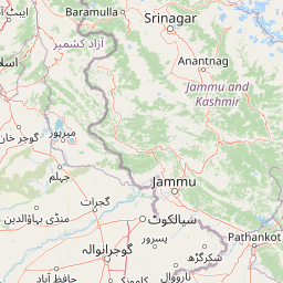
Map view of Salim Ali National Park

Use this park location map to pinpoint Salim Ali National Park in India, understand its exact geographic position, and read its mapped placement within the surrounding landscape more clearly.

Pigeon | © OpenStreetMap contributors

Location context for Salim Ali National Park

Jammu and Kashmir
Park atlas

Browse adjacent Himalayan protected areas and compare Kashmir valley forest ecosystems

Discover Other Protected Areas and National Parks Near Salim Ali National Park

Explore other national parks and protected areas situated within or around the broader Kashmir valley and Himalayan region, tracing diverse landscapes and conservation efforts connected to Salim Ali National Park's original purpose. Comparing these regional sites provides valuable geographic context for understanding habitat variations and the complex history of conservation across this distinct mountain terrain.
Protected areaJammu and Kashmir
About 9 km away#1 closest

West

Hokersar Protected Area: Wetland Geography and Map Context in Jammu and Kashmir

Migratory bird sanctuary and critical Jhelum basin wetland

Hokersar encompasses a distinct wetland landscape in northwestern India, characterized by shallow water, reed beds, and marshy pastures. As a key node for Palearctic waterbirds in the Kashmir Valley, the reserve provides essential flood-buffering services through its perennial stream network and seasonal snowmelt cycles, making it a focal point for regional ecological study.

Area
13.75 km²
Visitors
500K annual
Relief
Lowland
Climate
Temperate
National parkSrinagar district
About 22 km away#2 closest

East

Dachigam National Park: Protected Landscape Atlas and Geographic Context in Srinagar District

Mapped boundaries and natural terrain within India's national park system.

Gain insight into Dachigam National Park, a significant protected area located in the Srinagar district. This page provides detailed geographic context and an atlas-style view of its protected landscape. Understand its specific role as a national park and explore its mapped features, contributing to a comprehensive understanding of India's natural territories.

Area
141 km²
Established
1910
IUCN
II
Relief
Mountain
Nature reserveJammu and Kashmir
About 39 km away#3 closest

Northwest

Wular Lake Nature Reserve: Protected Wetland and Freshwater Geography in the Kashmir Valley

Tectonic freshwater lake and Ramsar-recognized protected area.

Wular Lake stands as one of the largest freshwater bodies in South Asia, characterized by its tectonic origin and its role as a critical component of the Jhelum River catchment. The protected nature reserve landscape currently encompasses a mosaic of open water, reed beds, and muddy shallows that provide habitat for endemic snowtrout and migratory bird populations throughout the Kashmir Valley.

Established
1990
Relief
Lowland
Climate
Temperate
Scope
Terrestrial
National parkBaramulla district
About 72 km away#4 closest

West

Kazinag National Park: Protected Area Geography and Mapped Boundaries in Baramulla District

Explore the regional landscape and terrain of this national park.

Kazinag National Park represents a distinct protected area within India's Baramulla district. This entry provides structured geographic information, focusing on the park's mapped boundaries and its role as a national park. Users can explore its landscape context and understand its specific regional terrain, contributing to a comprehensive atlas view of protected lands.

Area
160 km²
Established
1992
IUCN
II
Relief
Mountain
National parkPakistan
About 72 km away#5 closest

North

Gurez National Park: Pakistan's Alpine Protected Landscape and Wildlife Habitat

Explore its mapped terrain and regional geographic context.

Gurez National Park stands as a protected national park within Pakistan's breathtaking Himalayan mountain system. This park is crucial for conserving the endangered musk deer and safeguarding a fragile alpine ecosystem characterized by dramatic valleys, steep peaks, and the flowing Kishenganga River. Its relative isolation preserves a unique natural landscape and traditional cultural heritage, making it a point of interest for understanding remote wilderness and conservation efforts within the South Asian atlas.

IUCN
II
National parkGilgit-Baltistan
About 83 km away#6 closest

North

Himalaya National Park: Exploring Its Protected Boundaries and Mountainous Landscape in Gilgit-Baltistan

Mapped protected area within Pakistan's northern mountain region.

Himalaya National Park serves as a significant protected entity within the dramatic geography of Gilgit-Baltistan, Pakistan. This national park offers a focused view of its specific natural terrain and mapped boundaries, contributing to a broader atlas of conservation lands. Users can discover the park's role as a protected landscape, examining its integration within the regional context and understanding its unique geographic characteristics. The focus here is on the park's protected status and its place in the mapped natural environment of Northern Pakistan.

Area
2,263 km²
Established
2021
IUCN
II
Relief
Mountain
National parkGilgit-Baltistan
About 94 km away#7 closest

Northeast

Deosai National Park: A Premier High-Altitude Alpine Wilderness and Protected Landscape in Pakistan

Mapped boundaries and unique terrain within Gilgit-Baltistan's geography.

Deosai National Park is a key protected area in Pakistan's Gilgit-Baltistan region, characterized by its high-altitude alpine meadows and expansive plateau terrain. As a national park, it offers crucial insights into mapped landscapes and regional geography, particularly for understanding conservation efforts in extreme environments. The park's setting provides a unique lens through which to explore the distribution and characteristics of protected lands within the broader atlas of natural landscapes.

Area
3,584 km²
Established
1993
IUCN
Ib
Relief
Highland
National parkAzad Kashmir
About 98 km away#8 closest

West

Panjal Mastan National Park: High-Altitude Plateau Landscape in Azad Kashmir

Discover mapped terrain and protected area geography.

Panjal Mastan National Park represents a significant protected landscape within the Pir Panjal mountain range of Azad Kashmir, Pakistan. This national park is characterized by its expansive high-altitude plateau, sitting at an average elevation of 2,800 meters, offering a unique regional geography. Known for its dramatic mountainous surroundings and seasonal wildflower meadows that bloom in spring, the park provides valuable context for understanding the natural terrain and protected area distribution in this part of the western Himalayas.

Area
300 km²
IUCN
II
Relief
Mountain
Climate
Alpine

Common questions about visiting, size, designation, and location context for Salim Ali National Park

Salim Ali National Park FAQs for park facts, access, geography, and protected area context

Find quick answers about Salim Ali National Park, including protected-area facts, park geography, trail and visitor context, and how the park fits into its surrounding country and regional landscape.
MoriAtlas Explorer

Continue Your Protected Areas Search Across the Global Atlas

Deepen your exploration by continuing the structured search for national parks and protected areas worldwide. Utilize the comprehensive filtering capabilities to compare different conservation landscapes and refine your understanding of global park geography. Discover more about the distribution and characteristics of protected natural areas.

Global natural geography