Mori Atlas logo
National parkSamuel R. McKelvie National Forest

A study of grassland dune topography, planted forest mosaics, and regional protected-area geography.

Samuel R. McKelvie National Forest: Mapping the Sandhills Prairie and Pine Islands of Nebraska

Samuel R. McKelvie National Forest stands as a primary unit of protected land within the Nebraska Sandhills, offering a unique mosaic of open prairie grasslands and man-made pine islands. This geography-first resource illustrates the interplay between stabilized dune terrain, long-term conservation history, and the surrounding water-rich environment of Cherry County. Users can examine how these planted conifer stands contrast against the vast, grass-dominated horizons that characterize this section of the Great Plains.

SandhillsNebraskanational forestponderosa pinegrass prairieplanted forest islands

Samuel R. McKelvie National Forest

National park

Park overview

Structured park overview, official facts, and landscape profile for Samuel R. McKelvie National Forest

Samuel R. McKelvie National Forest park facts, protected area profile, and essential visitor context

Review the core facts for Samuel R. McKelvie National Forest, including designation, size, terrain, visitor scale, habitats, and operating context in one park-focused overview.

About Samuel R. McKelvie National Forest

Samuel R. McKelvie National Forest occupies a distinctive position within Nebraska's Sandhills, one of the most unusual prairie landscapes in North America. Rather than forming a continuous block of trees, the national forest appears as scattered pine stands and tracts of forest punctuating an expanse of native grassland. This pattern is a product of deliberate planting and management: most of the existing tree cover was established by hand over roughly three quarters of a century, creating "islands" of ponderosa pine, eastern juniper, and Scots pine amid an ocean of prairie.

The forest lies in north-central Nebraska within Cherry County, the state's largest county by area and a stronghold of the Sandhills ecosystem. Nearby Merritt Reservoir, built as a dam on the Snake River, adds a major water feature just south and east of the forest and supports fishing as well as camping and outdoor recreation. Combined, the forest and reservoir form a recognizable destination area for visitors exploring the Nebraska Sandhills.

Administratively, McKelvie is part of the Nebraska National Forests and Grasslands, a Forest Service unit that brings together multiple national forest and national grassland components across the state. From a broader conservation perspective, the national forest represents one of the more visible examples of long-term efforts to integrate tree cover, ranching leases, and native biodiversity within the Sandhills. Its mix of high-protein native grasses, planted pine, and resilient prairie wildlife gives it an identity quite different from either the forests of the Rocky Mountains or the open plains to its east.

Quick facts and research context for Samuel R. McKelvie National Forest

Samuel R. McKelvie National Forest is a federal national forest located in the Sandhills of north-central Nebraska, USA. The forest lies entirely within Cherry County and is administered by the U.S. Forest Service under the Nebraska National Forests and Grasslands supervisor's office.

It was designated as a national forest in 1971 by President Richard Nixon, separating from components of the older Niobrara Forest Reserve established by President Theodore Roosevelt in 1902. The forest is named for Samuel R. McKelvie, a former governor of Nebraska. Adjacent lands include Merritt Reservoir, a key water-oriented recreation area managed by the Nebraska Game and Parks Commission.

Protection and recognition

Documented terrestrial protection scope, designation year, and management records.

Samuel R. McKelvie National Forest Protection Status and Designation History

Samuel R. McKelvie National Forest maintains a documented terrestrial protection status established in 1971. Structured records outline the official management scope and designation history for the protected area.

Protection details

Protection scope
Terrestrial
Designated year
1971
Transboundary protection
No
Park context

Deeper park guide and search-rich context for Samuel R. McKelvie National Forest

Samuel R. McKelvie National Forest history, landscape, wildlife, and travel context

Explore Samuel R. McKelvie National Forest through its history, landscape character, ecosystems, wildlife, conservation priorities, cultural context, and seasonal travel timing in a structured park guide built for atlas discovery and search intent.

Why Samuel R. McKelvie National Forest stands out

McKelvie National Forest is best known for its unusual combination of native Sandhills prairie and man-made pine "islands." Most of the forest's trees were planted by hand over the past several decades, giving the landscape a patchwork pattern of grasslands and conifer stands that feels distinct from both pure prairie and traditional western forest. It is also recognized for its connection to Nebraska's conservation history, tracing back to the early twentieth-century Niobrara Forest Reserve. The surrounding region features high-protein native grasses that support both ranching leases and a thriving population of native Sandhills wildlife.
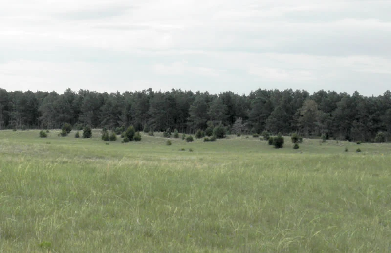
A wide, eye-level view of a rolling grassy prairie with scattered small shrubs and a dense forest line in the background under a pale, overcast sky.
The rolling grasslands and pine forest islands that characterize the Sandhills region of Samuel R. McKelvie National Forest.

Samuel R. McKelvie National Forest history and protected-area timeline

The history of Samuel R. McKelvie National Forest ties directly to a broader national forest tradition in the Sandhills. In 1902, President Theodore Roosevelt issued a proclamation establishing the Niobrara Forest Reserve. This reserve later became the Niobrara Ranger District, a component of the larger Nebraska National Forest system. The reserve reflected an early conservation-era emphasis on protecting sandhill landscapes and their future potential for sustained use.

Several decades later, in 1971, President Richard Nixon designated the Niobrara Division as its own national forest, renaming it Samuel R. McKelvie National Forest. The new name honored Samuel R. McKelvie, a former governor of Nebraska whose career connected him closely to the state's agricultural and political history. The 1971 designation effectively separated what had been one ranger district into a distinct federal national forest entity.

Over the following decades, the forest continued to evolve, particularly through long-running tree-planting programs that built up its pine stands and shaped the present-day forest-prairie mosaic. Meanwhile, the surrounding Merritt Reservoir developed into a recognized recreation anchor for the area, providing water-based activities alongside the grassland and forest landscape. The forest's modern identity reflects this layered history of early-twentieth-century conservation, mid-twentieth-century reform, and continuous on-the-ground land management.

Samuel R. McKelvie National Forest landscape and geographic character

Samuel R. McKelvie National Forest sits at the heart of the Nebraska Sandhills, a vast region of stabilized dune grasslands. The terrain is shaped by rolling, grass-covered dunes with sandy soils, giving the area its characteristic subtle undulations and open horizons. Vegetation is dominated by prairie grasses rather than trees, with the dune-formed topography visible through sweeping vistas of grassland broken only by scattered forest patches.

The defining visual feature is contrast: open prairie interrupted by planted pine "islands" of ponderosa pine, eastern juniper, and Scots pine. These forest stands stand out against the lighter tones of the surrounding grasslands, producing a landscape that reads as a true mosaic rather than continuous woodland. Ponderosa pine in particular has begun to spread on its own into adjacent areas, gradually extending the forested character of the region beyond the originally planted tracts.

To the south and east of the national forest lies Merritt Reservoir, a Snake River impoundment that introduces a major freshwater feature to the otherwise grass-dominated terrain. The reservoir's shoreline, set among low Sandhills ridges, adds visual variety and acts as a focal point for visitors moving between the forest and the water. Together, these elements create a landscape where prairie, pine, and reservoir meet within a single travel area.

Samuel R. McKelvie National Forest ecosystems, habitats, and plant life

Ecologically, Samuel R. McKelvie National Forest is a hybrid landscape where prairie and woodland ecosystems meet. The base ecological system is Sandhills prairie, with native grasses renowned for unusually high protein content. These grasses not only support the area's ranching tradition but also anchor the broader nutrient cycle of the soils and dependent wildlife. Tree growth in this setting is largely the result of deliberate planting, with the result that pine and juniper stands exist as managed fragments within a broader grassland matrix.

The forest's pine "islands" function as small woodland microhabitats within the prairie. They offer shelter, nesting sites, and cover for species that would not otherwise find suitable habitat in open grassland. Their presence also creates transitional "edge" environments where prairie and forest species overlap. The combination of high-protein grasses and tree cover gives the area a layered ecological structure, with both ground-level forage and elevated woody habitat coexisting across relatively short distances.

Merritt Reservoir adds an aquatic dimension to the surrounding ecological context. As an impoundment on the Snake River, it creates standing-water habitat and shoreline edges not found elsewhere in the immediate Sandhills. Because the reservoir sits adjacent to the forest, the larger travel area combines terrestrial prairie, planted woodland, and managed freshwater environments, supporting ecological variety despite the homogeneity of the surrounding dunes.

Samuel R. McKelvie National Forest wildlife and species highlights

Wildlife at Samuel R. McKelvie National Forest reflects the wider character of the Nebraska Sandhills, with strong representation of grassland-adapted mammals and a notably diverse bird community. Pronghorn are among the most visible native mammals, sharing the open landscape with white-tailed deer, mule deer, coyotes, and foxes.

The forest and surrounding grasslands support roughly 150 recorded bird species. Among the more commonly encountered birds are pheasants, grouse, hawks, and wild turkeys, all of which depend on the combination of grass cover and tree patches that McKelvie provides. Wild turkeys in particular benefit from the presence of pine stands, which offer roosting sites that open prairie alone cannot supply.

Beyond these signature species, the forest's mix of habitats, including prairie, pine islands, and nearby reservoir, allows a wider variety of wildlife to coexist than would be possible in a strictly grass-dominated ecosystem. Ranching leases on the native grasses further tie the wildlife context to the land-use history of the area, with grazing patterns and grassland management influencing forage availability for the larger herbivores and, in turn, the predators that follow them.

Samuel R. McKelvie National Forest conservation status and protection priorities

As a unit of the U.S. national forest system, Samuel R. McKelvie National Forest contributes to long-term conservation of the Nebraska Sandhills and to broader federal efforts to manage mixed grassland-forest landscapes under Forest Service stewardship. The forest's existence traces directly to early conservation-era policy, beginning with Theodore Roosevelt's 1902 Niobrara Forest Reserve proclamation, and continuing through later twentieth-century designations that recognized the Sandhills as worthy of distinct federal protection.

A central part of the forest's conservation role is the maintenance of both planted pine and native grass cover. Ponderosa pine stands require ongoing management because of harvesting pressures, but they have also begun to spread naturally, suggesting an evolving balance between active planting and regeneration. The native Sandhills grasses, notable for their high protein content, are themselves a conservation resource, supporting livestock leases and the wildlife that depends on intact grassland ecosystems.

The forest also connects to wider landscape-level conservation through its relationship with adjacent public lands, including Merritt Reservoir and other national forest and national grassland units managed under the same supervisor's office. This broader network of Nebraska National Forests and Grasslands makes McKelvie part of an integrated system of federally administered conservation lands rather than an isolated reserve, reinforcing the Sandhills' standing as one of the most distinctive working landscapes in the Great Plains.

Samuel R. McKelvie National Forest cultural meaning and human context

The cultural context of Samuel R. McKelvie National Forest is closely tied to Nebraska's Sandhills ranching heritage. High-protein native grasses have historically supported cattle operations, and the forest continues to be linked to local ranching through lease arrangements. This long-running relationship between grassland, livestock, and stewardship is a defining feature of the area's human landscape.

The forest's name itself reflects state-level political history. Honoring former Governor Samuel R. McKelvie connects the landscape to Nebraska's twentieth-century governance and to the era in which the modern national forest system expanded into the Sandhills. The earlier Niobrara Forest Reserve, established under Theodore Roosevelt, places the area within a recognizably American conservation tradition that emphasized the responsible use of unique public lands.

Management decisions, including where and how to plant trees, are intertwined with this cultural landscape. Many of the pine stands were planted by hand over decades, representing sustained, human-driven effort to shape the forest as it exists today. That combination of working land, conservation heritage, and grassroots tree planting gives McKelvie a layered cultural identity beyond its purely ecological character.

Top sights and standout views in Samuel R. McKelvie National Forest

McKelvie National Forest stands out for its visual contrast: open Sandhills prairie broken by dark pine "islands" planted over generations. This landscape pattern is rare in the central Great Plains and gives the forest much of its memorable identity. Combined with the proximity of Merritt Reservoir and its Snake River setting, the area offers visitors a paired experience of dune grassland, planted pine, and freshwater shoreline within a single short travel radius.

The forest also carries historical weight as a continuation of Theodore Roosevelt's early-twentieth-century conservation legacy in the Sandhills and as a tribute to a former Nebraska governor. Layered on top of that is its dual role as both a working ranching landscape, through grass leases, and a wildlife refuge for pronghorn, deer, and a notably rich bird community. These qualities together make McKelvie a distinctive piece of Nebraska's public-lands system.

Best time to visit Samuel R. McKelvie National Forest

Visit timing at McKelvie National Forest tends to follow the rhythm of the Sandhills landscape itself. Late spring and early summer bring fresh growth to the native grasses and active birdlife, while autumn often highlights warm tones across the prairie and the contrasting dark green of the pine stands. Summer heat is common in the region, though cooler evenings along the reservoir shoreline can make outdoor activity more comfortable.

In winter, the open prairie can feel especially exposed, but the pine "islands" offer some shelter and visual contrast against lighter grasses. Birding and wildlife viewing can be productive across multiple seasons because the forest supports roughly 150 bird species and a stable population of grassland mammals year-round. Visitors interested in combining forest days with time on the water may find late spring through early fall particularly rewarding, given the reservoir's role in the area's recreation scene.
Monthly climate preview

Long term temperature ranges and monthly precipitation patterns across representative terrain

Samuel R. McKelvie National Forest Climate Normals and Temperature Rhythms

Representative coordinate sampling reveals measured monthly temperature swings alongside shifting precipitation rates across the protected landscape. Examining the complete twelve month climate record clarifies the long term environmental rhythm of Samuel R. McKelvie National Forest.
Annual mean10 °C
-3 °C25 °C
Jan-3°
Feb-2°
Mar
Apr
May15°
Jun21°
Jul25°
Aug23°
Sep18°
Oct
Nov
Dec-3°
Warmest month
July

24.6 °C

Coolest month
January

-3.2 °C

Wettest month
June

3 mm/day

Driest month
January

0.3 mm/day

Park location guide

Geography guide, regional context, and park location map for Samuel R. McKelvie National Forest

Samuel R. McKelvie National Forest park geography, regions, and map view in United States of America

Understand where Samuel R. McKelvie National Forest sits in United States of America through a broader geographic reading of the surrounding landscape, nearby location context, and its mapped position within the national park landscape.

How Samuel R. McKelvie National Forest fits into United States of America

The United States of America is a federal presidential republic and one of the world's largest countries by area and population. It consists of 50 states across a vast territory spanning multiple time zones, with its capital in Washington, D.C. and largest city in New York City. The nation has a diverse economy, influential political system, and significant cultural and military presence globally.

Wider geography shaping Samuel R. McKelvie National Forest in United States of America

The United States occupies a vast territory in North America, bordered by Canada to the north and Mexico to the south. The 48 contiguous states stretch from the Atlantic to the Pacific Ocean, while Alaska occupies the northwestern region and Hawaii is an archipelago in the Pacific. The country encompasses diverse terrain including the Rocky Mountains, Appalachian Mountains, Great Plains, and extensive river systems.

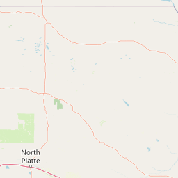
Map view of Samuel R. McKelvie National Forest

Use this park location map to pinpoint Samuel R. McKelvie National Forest in United States of America, understand its exact geographic position, and read its mapped placement within the surrounding landscape more clearly.

Pigeon | © OpenStreetMap contributors

Location context for Samuel R. McKelvie National Forest

Cherry CountyNebraska
Recorded earthquake history

View Historical Earthquake Records for Samuel R. McKelvie National Forest

Examine the historical catalogue of seismic events recorded near Samuel R. McKelvie National Forest. This MoriAtlas dataset provides structured access to magnitude, depth, and location data for all documented activity within the surrounding Sandhills region.

Samuel R. McKelvie National Forest Earthquake History

Catalogued events

7 events

Strongest magnitude

Magnitude 3.3

Most recent event

Jan 1, 2025

This history includes earthquakes recorded inside the park or within 50 km of its borders

Visual reference of planted pine islands across Nebraska dune grasslands

Samuel R. McKelvie National Forest Photos and Landscape Scenery

Photographic documentation reveals the distinctive terrain of Samuel R. McKelvie National Forest through open prairie grasslands and conifer stands. Visual archives help researchers examine the unique protected-area character formed by rolling sand dunes and hand-planted timber tracts.

A wide, eye-level view of a rolling grassy prairie with scattered small shrubs and a dense forest line in the background under a pale, overcast sky.

Park atlas

Compare regional geography, dune grasslands, and connected conservation units across the Sandhills

Explore Other Parks Near Samuel R. McKelvie National Forest and Surrounding Protected Landscapes

Browse nearby national forests and protected areas that share the unique Sandhills geography of Samuel R. McKelvie National Forest. Comparing these regional conservation units reveals broader patterns of dune grasslands and planted pine ecosystems.
National parkSouth Dakota
113 km away#1 closest

Northwest

Badlands National Park: South Dakota's Premier National Park for Atlas Exploration

Explore mapped terrain and protected landscape boundaries.

Badlands National Park stands as a key protected area within the geography of South Dakota, offering a distinct natural landscape for detailed atlas exploration. This National Park's unique terrain and mapped boundaries provide crucial context for understanding regional geography and conservation landscapes. Engage with structured information that highlights the park's geographic identity, making it an essential destination for those seeking to map and comprehend protected natural areas.

Area
982.4 km²
Established
1939
IUCN
II
Visitors
1M annual
A watercolor painting showing a rolling landscape with green hills, patches of coniferous forest, and a soft, hazy sky.
Protected landscapeNebraska
About 132 km away#2 closest

West

Nebraska National Forest: Geographic Context and Protected Landscape Boundaries

Mapped terrain across Sandhills and Pine Ridge districts.

This protected landscape is defined by its unusual dual-district structure, encompassing both the historic tree-planting experiments in the central Sandhills and the rugged, native pine-covered canyons of the Pine Ridge. Discover how these distinct environmental zones create a unique ecological footprint within the broader Nebraska geography through detailed map-based insights.

Area
574.1 km²
Established
1908
Relief
Upland
Climate
Temperate
Protected areaSouth Dakota
139 km away#3 closest

North

Fort Pierre National Grassland: An Atlas of South Dakota Mixed-Grass Prairie Ecosystems

Exploration of central Great Plains protected terrain and boundaries

Focusing on the authentic mixed-grass prairie of South Dakota, Fort Pierre National Grassland serves as a critical example of northern Plains conservation. Its landscape, marked by sweeping vistas and seasonal wetlands, provides a deep look into the spatial character and ecological heritage of the interior United States. Gain a precise understanding of its boundaries and the surrounding geographic features that define this expansive public land.

Area
469 km²
Relief
Upland
Access
Access unknown
Scope
Terrestrial
A pale, minimalist watercolor illustration of a wide, open grassy landscape with soft rolling hills in the background and light green vegetation in the foreground.
Protected landscapeSouth Dakota
About 153 km away#4 closest

Northwest

Buffalo Gap National Grassland: Regional Geography and Protected Prairie Boundaries

Mapping the vast grasslands of southwestern South Dakota

Spanning across four counties in southwestern South Dakota, Buffalo Gap National Grassland serves as a premier example of a working Great Plains landscape. The region is defined by its immense scale, where undulating mixed-grass prairie transitions into striking, chalky badlands. This area is recognized for its vital conservation role, including successful species recovery programs, and stands as a foundational feature of the regional geological and ecological map.

Area
2,410.77 km²
Established
1960
Relief
Upland
Climate
Temperate
Watercolor painting of a wide, rolling grassy plain leading to distant low hills or badlands against a pale sky.
Protected landscapeNebraska
171 km away#5 closest

West

Oglala National Grassland: Geological Terrain and Protected Landscape Map in Nebraska

Regional geography of prairie rangelands and eroded badlands

Situated in the northwest corner of Nebraska, Oglala National Grassland covers nearly 95,000 acres of shortgrass prairie and badlands. This protected landscape is defined by the unique exposure of Pierre Shale, creating a terrain characterized by deep gullies, banded sedimentary rock, and hoodoo formations that provide essential habitat and a deep record of natural history.

Area
382.5 km²
Relief
Upland
Climate
Arid
Access
Easy access
National parkCuster County
190 km away#6 closest

Northwest

Wind Cave National Park: A National Park with Distinct Protected Landscape and Geographic Identity

Explore the mapped terrain and regional context of this US protected area.

Wind Cave National Park represents a key protected area within Custer County, offering users a deep dive into its unique geography and landscape characteristics. As a designated national park in the United States, its mapped boundaries provide crucial context for understanding its ecological and geological significance. This MoriAtlas entry facilitates detailed exploration, focusing on the protected land's identity and its role within the wider regional geography and natural landscape.

Area
136.97 km²
Established
1903
IUCN
II
Visitors
489.4K annual
Protected landscapeWyoming
264 km away#7 closest

West

Thunder Basin National Grassland: A Protected Landscape in the Wyoming Powder River Basin

Mapping the prairie and sagebrush mosaic of northeastern Wyoming

Thunder Basin National Grassland is a sprawling, federally protected territory in northeastern Wyoming that functions as a critical ecotone between the Great Plains and the Rocky Mountain region. Its landscape is characterized by wide-open vistas, intricate sedimentary bluffs, and diverse habitats shaped by natural disturbance patterns and ongoing grassland management. This record outlines the geography, terrain features, and protected boundaries that define this essential segment of the American West.

Area
2,215.65 km²
Established
1960
Relief
Upland
Climate
Arid
A soft watercolor painting of a wide, rolling grassy landscape with a pale sky and hints of a treeline in the distance.
Protected landscapeColorado
278 km away#8 closest

Southwest

Pawnee National Grassland: Protected Landscape and Great Plains Atlas

Shortgrass prairie and geologic remnants in Colorado.

Pawnee National Grassland represents a significant protected area within northeastern Colorado, spanning vast semiarid plains and striking erosional formations known as the Pawnee Buttes. This atlas overview details the park boundaries, regional drainage systems of the South Platte River basin, and the ecological value of these native grass communities and scarp woodlands.

Area
781.3 km²
Established
1960
Relief
Upland
Climate
Arid

Common questions about visiting, size, designation, and location context for Samuel R. McKelvie National Forest

Samuel R. McKelvie National Forest FAQs for park facts, access, geography, and protected area context

Find quick answers about Samuel R. McKelvie National Forest, including protected-area facts, park geography, trail and visitor context, and how the park fits into its surrounding country and regional landscape.
MoriAtlas Explorer

Continue Your Protected Areas Search Across the Global Atlas

Deepen your exploration by continuing the structured search for national parks and protected areas worldwide. Utilize the comprehensive filtering capabilities to compare different conservation landscapes and refine your understanding of global park geography. Discover more about the distribution and characteristics of protected natural areas.

Global natural geography