Why Sanin Kaigan National Park stands out
Sanin Kaigan is especially known for its dramatic coastal geology and diverse shoreline landscapes. The Tottori Sand Dunes, Japan's largest sand dunes, dominate the northern portion of the park and create an unexpected desert-like environment adjacent to the sea. The park's many sea caves, notably Genbudō Cave with its distinctive basalt column formations, showcase volcanic geological history. The varied coastline features towering cliffs, hidden beaches, rocky islands, and pristine coastal stretches that contrast sharply with Japan's typically mountainous interior. The combination of coastal geomorphology, the unique sand dune ecosystem, and the geological significance of the Global Geopark designation makes this park distinctive among Japan's protected coastal areas.
Sanin Kaigan National Park history and protected-area timeline
Sanin Kaigan became a national park in 1963 as part of Japan's post-war expansion of protected areas. The establishment reflected growing recognition of the coast's unique geological and scenic value during a period when Japan was systematically identifying and designating national parks to preserve outstanding natural landscapes. The park's creation came during a broader movement to protect Japan's coastal environments, which had often been overlooked in favor of mountain and forest areas. Since designation, the park has been managed by the Ministry of the Environment in coordination with local prefectural governments, balancing conservation with sustainable access. The later recognition of the broader San'in Kaigan area as a Global Geopark has added another layer of international recognition for the geological significance that helped drive the original park designation.
Sanin Kaigan National Park landscape and geographic character
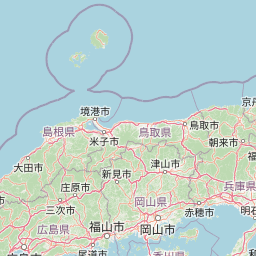
The park's landscape is defined by the dynamic interface between land and sea along this exposed Sea of Japan coast. The northern section features the Tottori Sand Dunes, a rare sandy landscape extending along several kilometers of shoreline where wind and ocean currents have created an evolving terrain of ridges, valleys, and parabolic dunes that shift with seasonal winds. South of the dunes, the coastline becomes increasingly rocky and cliff-bound, with steep headlands projecting into the sea and narrow inlets cutting into the shore. The numerous coves and small beaches are often backed by forested slopes, creating intimate scenic compositions. Sea caves are a particular feature, including Genbudō Cave where hexagonal basalt columns create a cathedral-like interior. The Uradome Coast offers particularly dramatic scenery with its chain of rocky islands, sea stacks, and clear turquoise waters visible through gaps in the cliff line. The coast also includes small volcanic outcrops that interrupt the more typical sedimentary geology.
Sanin Kaigan National Park ecosystems, habitats, and plant life
The park's natural environment reflects the transitional climate between Japan's Pacific and Sea of Japan sides, producing a coastal ecosystem adapted to relatively heavy snowfall in winter and humid summers. Vegetation along the coast consists primarily of Japanese black pine forests that have been shaped by wind and salt spray, creating characteristic wind-pruned forms on exposed headlands. The pine trees play an important role in stabilizing sandy areas and preventing erosion along the dune margins. Inland slopes support mixed deciduous forest typical of the San'in region. The marine environment along the coast supports productive fisheries and diverse intertidal communities where rocky shores give way to sandy beaches. The park's designation as part of a Global Geopark emphasizes geological heritage alongside biological values, with interpretative focus on the volcanic origins and subsequent coastal erosion processes that shaped the present landscape.
Sanin Kaigan National Park wildlife and species highlights
The coastal and near-shore environments support characteristic Sea of Japan wildlife assemblages. The Japanese black pine dominates the park's terrestrial vegetation, forming wind-shaped forests along the coast that provide habitat for various bird species. The black-tailed gull is a common coastal bird, nesting on cliff ledges and foraging along the shore. The Japanese martin, a swallow species, frequents the coastal areas and can be observed hunting insects over the water. Marine birds including cormorants and various duck species use the coastal waters seasonally. The rocky shores and intertidal zones support diverse invertebrate communities, while the surrounding seas contain fish species important to local fisheries. The dunes host specialized dune-adapted plants and invertebrates that have evolved to cope with the challenging sandy environment, creating an unusual ecosystem within the broader park landscape.
Sanin Kaigan National Park conservation status and protection priorities
Sanin Kaigan National Park represents an important coastal conservation priority in Japan, protecting representative examples of Sea of Japan coastal ecosystems and geological features. The park's inclusion in the San'in Kaigan Global Geopark network reinforces its conservation significance at an international level, emphasizing geological heritage alongside biodiversity values. The diverse coastal habitats, from sandy dunes to rocky cliffs and marine environments, form an interconnected ecosystem that supports both endemic species and migratory populations. Management focuses on maintaining the natural processes that shape this dynamic coastline while providing controlled access for environmental education and appreciation. The Global Geopark designation has encouraged interpretation of geological features and promoted understanding of the ongoing coastal processes that continue to shape the landscape.
Sanin Kaigan National Park cultural meaning and human context
The San'in coast has been inhabited for centuries, with fishing communities developing along this productive shoreline. The coastal towns within and adjacent to the park retain traditional maritime cultures tied to fishing and seafood processing. The landscape has inspired Japanese artistic traditions, with the dramatic cliffs and changing light over the Sea of Japan appearing in classical poetry and paintings. The area is also associated with historical shipping routes and coastal navigation. Local communities maintain connections to the coastline through traditional practices and seasonal festivals that celebrate the marine environment. While the park itself is designated primarily for natural preservation, the surrounding cultural landscape reflects the long human history of interaction with this dramatic seacoast.
Top sights and standout views in Sanin Kaigan National Park
The Tottori Sand Dunes stand as the park's most iconic landscape, a rare sandy expanse where visitors can experience what feels like a desert within Japan. Genbudō Cave showcases spectacular hexagonal basalt columns formed from ancient volcanic activity. The various coastal sections including Takeno, Uradome, Kasumi, and Tajima each offer distinctive scenery from dramatic cliff walks to hidden coves accessible by boat. The park provides excellent opportunities for coastal hiking along the San'in Kaigan Trail, with routes offering views of the distinctive geological formations and changing coastal scenery. The contrast between the desert-like dunes and the lush forested cliffs exemplifies the diversity within this relatively compact park.
Best time to visit Sanin Kaigan National Park
The park can be enjoyed throughout the year, with each season offering different character. Summer brings warm weather ideal for beach activities and coastal walking, though this is also the peak tourist season. Autumn offers comfortable temperatures and fewer crowds, with October and November providing particularly pleasant conditions for hiking along the coast. Winter transforms the landscape, with heavy snowfall on the cliffs creating dramatic contrasts against the dark sea and providing a different but equally compelling visual experience. Spring brings mild temperatures and the renewal of vegetation, though the transitional weather can be variable. The park's coastal location means that weather can change rapidly, particularly in winter when storm systems can produce dramatic wave action along the shore.