Mori Atlas logo
National parkSanin Kaigan National Park

Trace the geographic boundaries of this national park within Tottori Prefecture's atlas context.

Sanin Kaigan National Park: Mapped Protected Landscape and Regional Geography in Tottori

(San'in Kaigan Kokuritsu Kōen)

Sanin Kaigan National Park represents a significant protected area within the geographic landscape of Tottori Prefecture. This entry serves as a detailed atlas entry, focusing on the park's mapped boundaries and its place within the regional geography. Users can explore the protected landscape identity of Sanin Kaigan National Park, understanding its specific features and its contribution to the mapped natural areas of Japan. The focus is on providing clear geographic context and detailed park information for structured exploration.

Coastal national parkSea of JapanSand dunesSea cavesGeoparkRocky coastline

Sanin Kaigan National Park

National park

Park overview

Structured park overview, official facts, and landscape profile for Sanin Kaigan National Park

Sanin Kaigan National Park park facts, protected area profile, and essential visitor context

Review the core facts for Sanin Kaigan National Park, including designation, size, terrain, visitor scale, habitats, and operating context in one park-focused overview.

About Sanin Kaigan National Park

Sanin Kaigan National Park preserves a remarkable stretch of Japan's Sea of Japan coastline where geological forces have created an extraordinary diversity of coastal landforms within a relatively compact area. The park extends across three prefectures, creating a continuous protected corridor that follows the shoreline from the dunes of Tottori in the north through the rugged cliffs of Hyōgo to the more gentle coastlines of northern Kyoto Prefecture. This longitudinal layout allows visitors to experience dramatic variations in landscape character within a single park, from the sweeping sand dunes that reach heights of 50 meters to narrow sea caves carved into volcanic Basalt and sheer cliffs beaten by winter storm waves. The geological diversity reflects the complex tectonic history of this region, where volcanic activity and subsequent erosion have produced the complex coastal scenery visible today. Beyond its scenic value, the park serves important ecological functions as a coastal habitat corridor and provides natural buffers protecting coastal communities from storm surges and erosion.

Quick facts and research context for Sanin Kaigan National Park

Sanin Kaigan National Park occupies 87.83 square kilometers along the Sea of Japan coast in the San'in region, crossing Tottori, Hyōgo, and Kyoto prefectures. The park was established on July 15, 1963, and is administered by Japan's Ministry of the Environment. The coastline features numerous inlets, rock formations, islands, and caves carved by wave action and geological processes. The park encompasses several distinct coastal areas including the Takeno Coast, Uradome Coast, Kasumi Coast, and Tajima Coast, each offering different landscape characteristics and scenic qualities.

Protection and recognition

Tracking the official designation framework and documented protection scope established in 1963.

Sanin Kaigan National Park Protection Status and Conservation Designation

Researchers and conservation explorers can review the official protection framework of Sanin Kaigan National Park, which was established in 1963 with a mixed management scope. Accurate geographic records clarify the administrative boundaries and designation history of the park within the broader Japanese protected area network.

Protection details

Protection scope
Mixed
Designated year
1963
Transboundary protection
No
Park context

Deeper park guide and search-rich context for Sanin Kaigan National Park

Sanin Kaigan National Park history, landscape, wildlife, and travel context

Explore Sanin Kaigan National Park through its history, landscape character, ecosystems, wildlife, conservation priorities, cultural context, and seasonal travel timing in a structured park guide built for atlas discovery and search intent.

Why Sanin Kaigan National Park stands out

Sanin Kaigan is especially known for its dramatic coastal geology and diverse shoreline landscapes. The Tottori Sand Dunes, Japan's largest sand dunes, dominate the northern portion of the park and create an unexpected desert-like environment adjacent to the sea. The park's many sea caves, notably Genbudō Cave with its distinctive basalt column formations, showcase volcanic geological history. The varied coastline features towering cliffs, hidden beaches, rocky islands, and pristine coastal stretches that contrast sharply with Japan's typically mountainous interior. The combination of coastal geomorphology, the unique sand dune ecosystem, and the geological significance of the Global Geopark designation makes this park distinctive among Japan's protected coastal areas.

Sanin Kaigan National Park history and protected-area timeline

Sanin Kaigan became a national park in 1963 as part of Japan's post-war expansion of protected areas. The establishment reflected growing recognition of the coast's unique geological and scenic value during a period when Japan was systematically identifying and designating national parks to preserve outstanding natural landscapes. The park's creation came during a broader movement to protect Japan's coastal environments, which had often been overlooked in favor of mountain and forest areas. Since designation, the park has been managed by the Ministry of the Environment in coordination with local prefectural governments, balancing conservation with sustainable access. The later recognition of the broader San'in Kaigan area as a Global Geopark has added another layer of international recognition for the geological significance that helped drive the original park designation.

Sanin Kaigan National Park landscape and geographic character

The park's landscape is defined by the dynamic interface between land and sea along this exposed Sea of Japan coast. The northern section features the Tottori Sand Dunes, a rare sandy landscape extending along several kilometers of shoreline where wind and ocean currents have created an evolving terrain of ridges, valleys, and parabolic dunes that shift with seasonal winds. South of the dunes, the coastline becomes increasingly rocky and cliff-bound, with steep headlands projecting into the sea and narrow inlets cutting into the shore. The numerous coves and small beaches are often backed by forested slopes, creating intimate scenic compositions. Sea caves are a particular feature, including Genbudō Cave where hexagonal basalt columns create a cathedral-like interior. The Uradome Coast offers particularly dramatic scenery with its chain of rocky islands, sea stacks, and clear turquoise waters visible through gaps in the cliff line. The coast also includes small volcanic outcrops that interrupt the more typical sedimentary geology.

Sanin Kaigan National Park ecosystems, habitats, and plant life

The park's natural environment reflects the transitional climate between Japan's Pacific and Sea of Japan sides, producing a coastal ecosystem adapted to relatively heavy snowfall in winter and humid summers. Vegetation along the coast consists primarily of Japanese black pine forests that have been shaped by wind and salt spray, creating characteristic wind-pruned forms on exposed headlands. The pine trees play an important role in stabilizing sandy areas and preventing erosion along the dune margins. Inland slopes support mixed deciduous forest typical of the San'in region. The marine environment along the coast supports productive fisheries and diverse intertidal communities where rocky shores give way to sandy beaches. The park's designation as part of a Global Geopark emphasizes geological heritage alongside biological values, with interpretative focus on the volcanic origins and subsequent coastal erosion processes that shaped the present landscape.

Sanin Kaigan National Park wildlife and species highlights

The coastal and near-shore environments support characteristic Sea of Japan wildlife assemblages. The Japanese black pine dominates the park's terrestrial vegetation, forming wind-shaped forests along the coast that provide habitat for various bird species. The black-tailed gull is a common coastal bird, nesting on cliff ledges and foraging along the shore. The Japanese martin, a swallow species, frequents the coastal areas and can be observed hunting insects over the water. Marine birds including cormorants and various duck species use the coastal waters seasonally. The rocky shores and intertidal zones support diverse invertebrate communities, while the surrounding seas contain fish species important to local fisheries. The dunes host specialized dune-adapted plants and invertebrates that have evolved to cope with the challenging sandy environment, creating an unusual ecosystem within the broader park landscape.

Sanin Kaigan National Park conservation status and protection priorities

Sanin Kaigan National Park represents an important coastal conservation priority in Japan, protecting representative examples of Sea of Japan coastal ecosystems and geological features. The park's inclusion in the San'in Kaigan Global Geopark network reinforces its conservation significance at an international level, emphasizing geological heritage alongside biodiversity values. The diverse coastal habitats, from sandy dunes to rocky cliffs and marine environments, form an interconnected ecosystem that supports both endemic species and migratory populations. Management focuses on maintaining the natural processes that shape this dynamic coastline while providing controlled access for environmental education and appreciation. The Global Geopark designation has encouraged interpretation of geological features and promoted understanding of the ongoing coastal processes that continue to shape the landscape.

Sanin Kaigan National Park cultural meaning and human context

The San'in coast has been inhabited for centuries, with fishing communities developing along this productive shoreline. The coastal towns within and adjacent to the park retain traditional maritime cultures tied to fishing and seafood processing. The landscape has inspired Japanese artistic traditions, with the dramatic cliffs and changing light over the Sea of Japan appearing in classical poetry and paintings. The area is also associated with historical shipping routes and coastal navigation. Local communities maintain connections to the coastline through traditional practices and seasonal festivals that celebrate the marine environment. While the park itself is designated primarily for natural preservation, the surrounding cultural landscape reflects the long human history of interaction with this dramatic seacoast.

Top sights and standout views in Sanin Kaigan National Park

The Tottori Sand Dunes stand as the park's most iconic landscape, a rare sandy expanse where visitors can experience what feels like a desert within Japan. Genbudō Cave showcases spectacular hexagonal basalt columns formed from ancient volcanic activity. The various coastal sections including Takeno, Uradome, Kasumi, and Tajima each offer distinctive scenery from dramatic cliff walks to hidden coves accessible by boat. The park provides excellent opportunities for coastal hiking along the San'in Kaigan Trail, with routes offering views of the distinctive geological formations and changing coastal scenery. The contrast between the desert-like dunes and the lush forested cliffs exemplifies the diversity within this relatively compact park.

Best time to visit Sanin Kaigan National Park

The park can be enjoyed throughout the year, with each season offering different character. Summer brings warm weather ideal for beach activities and coastal walking, though this is also the peak tourist season. Autumn offers comfortable temperatures and fewer crowds, with October and November providing particularly pleasant conditions for hiking along the coast. Winter transforms the landscape, with heavy snowfall on the cliffs creating dramatic contrasts against the dark sea and providing a different but equally compelling visual experience. Spring brings mild temperatures and the renewal of vegetation, though the transitional weather can be variable. The park's coastal location means that weather can change rapidly, particularly in winter when storm systems can produce dramatic wave action along the shore.
Monthly climate preview

Track long-term temperature ranges and precipitation trends across the protected landscape

Sanin Kaigan National Park Climate Normals and Average Monthly Weather Patterns

Sanin Kaigan National Park exhibits a recorded annual temperature rhythm spanning from mean winter lows near freezing to mid-summer highs exceeding thirty degrees Celsius alongside varying daily precipitation. Examining the complete monthly climate dataset provides structured insight into long-term averages for every recorded period.
Annual mean14 °C
4 °C26 °C
Jan
Feb
Mar
Apr11°
May16°
Jun20°
Jul24°
Aug26°
Sep22°
Oct17°
Nov11°
Dec
Warmest month
August

25.6 °C

Coolest month
January

3.8 °C

Wettest month
September

7 mm/day

Driest month
April

3.6 mm/day

Park location guide

Geography guide, regional context, and park location map for Sanin Kaigan National Park

Sanin Kaigan National Park park geography, regions, and map view in Japan

Understand where Sanin Kaigan National Park sits in Japan through a broader geographic reading of the surrounding landscape, nearby location context, and its mapped position within the national park landscape.

How Sanin Kaigan National Park fits into Japan

Japan is an island nation in East Asia comprising over 14,000 islands in the Pacific Ocean. The country operates as a unitary parliamentary constitutional monarchy with Emperor Naruhito as the reigning monarch and Prime Minister Sanae Takaichi leading the government. With a population of approximately 123 million, Japan is the world's 11th most populous country and a major economic power with one of the strongest militaries, though it has constitutionally renounced its right to declare war.

Wider geography shaping Sanin Kaigan National Park in Japan

Japan is an island nation in the Pacific Ocean, bordered to the west by the Sea of Japan and extending from the Sea of Okhotsk in the north to the East China Sea in the south. The Japanese archipelago lies off the northeast coast of the Asian mainland. Approximately 75% of Japan's terrain is mountainous and heavily forested, with agricultural land and urbanized populations concentrated along the eastern coastal plains. The country is divided into 47 administrative prefectures and eight traditional regions.

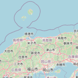
Map view of Sanin Kaigan National Park

Use this park location map to pinpoint Sanin Kaigan National Park in Japan, understand its exact geographic position, and read its mapped placement within the surrounding landscape more clearly.

Pigeon | © OpenStreetMap contributors

Location context for Sanin Kaigan National Park

Hyōgo PrefectureKyōto PrefectureTottori Prefecture
Park atlas

Trace the broader geographic spread of national parks and protected areas in western Honshu, Japan, from dramatic coastlines to volcanic formations.

Explore Nearby Protected Areas Around Sanin Kaigan National Park: Compare Coastal Landscapes and Regional Geography

Continue your exploration of Japan's protected areas after Sanin Kaigan National Park by browsing other nearby national parks and regional protected landscapes across western Honshu. Discover how contiguous coastal geology, unique sand dunes, and diverse volcanic formations connect a wider network of conservation efforts and geographic features.
National parkChūgoku region
About 79 km away#1 closest

West

Daisen-Oki National Park: A National Park within the Chūgoku Region's Protected Landscape Atlas

Mapped geography and protected land context.

Gain a structured understanding of Daisen-Oki National Park, a designated national park situated in Japan's Chūgoku region. This entry focuses on its precise geographic location, mapped protected boundaries, and its role within a broader landscape atlas. Explore the fundamental geographic characteristics that define this key natural area, providing essential context for regional and national park discovery.

Area
694.105 km²
Established
1936
IUCN
II
Visitors
9.3M annual
National parkJapan
About 201 km away#2 closest

Southwest

Setonaikai National Park: Japan's Premier Island Archipelago and Coastal Protected Landscape

Explore the unique marine geography and mapped island environments.

Setonaikai National Park is Japan's largest national park, renowned for its stunning marine environment within the Seto Inland Sea. This protected area features approximately 3,000 islands, showcasing weathered granite formations, coastal forests, and dynamic tidal phenomena like the Naruto whirlpools. The park offers a unique atlas-style exploration of island geography, coastal landscapes, and significant cultural sites, making it a cornerstone of Japan's protected natural heritage.

Area
669.34 km²
Established
1934
IUCN
II
Visitors
40.6M annual
Watercolor illustration of a mountain landscape with a lake, grasses, and flowers
National parkIshikawa Prefecture
About 205 km away#3 closest

East

Hakusan National Park: Sacred Mountain Protected Landscape in Ishikawa Prefecture

Mapped alpine terrain and volcanic geography for protected area discovery.

Hakusan National Park offers a unique exploration of Japan's sacred mountain heritage and alpine natural beauty. This protected landscape, centered on Mount Haku, features distinct volcanic terrain, crater lakes, and exceptional alpine flora. Users can explore the park's mapped boundaries, understand its place within Ishikawa Prefecture's geography, and appreciate its role as a significant UNESCO Biosphere Reserve for detailed atlas-based discovery.

Area
477 km²
Established
1962
IUCN
II
Relief
Mountain
National parkMie Prefecture
About 235 km away#4 closest

Southeast

Ise-Shima National Park: Explore the Sacred Sacred Sites and Striking Ria Coast Geography of Mie Prefecture

Mapped protected landscapes and natural terrain context.

Ise-Shima National Park is a jewel of Japan's protected natural areas, renowned for its distinctive ria coast topography where mountainous terrain meets the sea. Discover the park's intricate geography, from the island-dotted Ago Bay to the wooded ridges surrounding Mount Asama-ga-take. This national park is not only a testament to the beauty of coastal landscapes but also a profoundly spiritual place, home to the highly revered Ise Jingū and the iconic Meoto Iwa. Its designation as a national park highlights the importance of conserving both its unique marine environments and its rich cultural heritage, offering a deep dive into Japan's natural and sacred geography.

Area
746.44 km²
Established
1946
IUCN
II
Visitors
8.2M annual
National parkKansai
About 239 km away#5 closest

Southeast

Yoshino-Kumano National Park: Protected National Park with Sacred Mountain Landscapes and Ancient Routes

Explore mapped park boundaries, gorges, and pilgrimage routes in Kansai.

Yoshino-Kumano National Park, a significant national park in Japan's Kansai region, invites exploration of its protected landscapes, which are deeply intertwined with spiritual heritage. Discover the park's rugged mountain terrain, ancient cypress and cedar forests, dramatic gorges like Dorokyō Gorge, and iconic coastal areas. This park is a vital entry for understanding Japan's confluence of natural geography and cultural pilgrimage, offering rich context for mapped landscape discovery.

Area
616.04 km²
Established
1936
IUCN
II
Relief
Mountain
Watercolor illustration showing mountains, a lake, and vegetation
National parkChūbu region
About 312 km away#6 closest

Northeast

Chūbu-Sangaku National Park: Japan's Iconic Alpine Protected Landscape and Northern Alps Atlas

Rugged peaks, alpine valleys, and mapped geography.

Chūbu-Sangaku National Park represents Japan's most significant alpine protected area, encompassing the dramatic heart of the Hida Mountains, or Northern Alps. Established in 1934, this national park is celebrated for its towering peaks, deep gorges, and as the source of Japan's longest river. Its rugged terrain offers unparalleled opportunities for exploring mapped alpine landscapes and understanding the geography of Japan's most prominent mountain wilderness.

Area
1,743.23 km²
Established
1934
IUCN
II
Relief
Mountain
Watercolor painting of green and pink mountain ranges with forested foreground and distant peaks.
National parkChūbu region
About 323 km away#7 closest

East

Minami Alps National Park: A Protected Alpine Wilderness in Japan's Chūbu Region

Discover its dramatic peaks and vital river headwaters.

Minami Alps National Park offers a profound exploration into Japan's high-altitude natural geography. As a national park, it preserves a dramatic alpine environment defined by glacially carved terrain and multiple peaks exceeding 3000 meters. This protected landscape serves as a vital watershed, safeguarding the origins of major river systems and showcasing a rugged mountain character distinct from more accessible areas, ideal for understanding protected wildlands.

Area
357.52 km²
Established
1964
IUCN
II
Relief
Mountain
National parkJapan
About 344 km away#8 closest

Northeast

Myōkō-Togakushi Renzan National Park: Mapped Protected Landscape Geography in Japan

Explore the park's regional terrain and protected area context.

Delve into the geographic specificities of Myōkō-Togakushi Renzan National Park, a key protected landscape in Japan. This entry focuses on its mapped terrain, regional setting, and the atlas-value of understanding its protected boundaries. Gain clarity on the park's distinct natural geography and its contribution to the broader protected area network.

Area
397.72 km²
Established
2015
IUCN
II
Relief
Mountain

Common questions about visiting, size, designation, and location context for Sanin Kaigan National Park

Sanin Kaigan National Park FAQs for park facts, access, geography, and protected area context

Find quick answers about Sanin Kaigan National Park, including protected-area facts, park geography, trail and visitor context, and how the park fits into its surrounding country and regional landscape.
MoriAtlas Explorer

Continue Your Protected Areas Search Across the Global Atlas

Deepen your exploration by continuing the structured search for national parks and protected areas worldwide. Utilize the comprehensive filtering capabilities to compare different conservation landscapes and refine your understanding of global park geography. Discover more about the distribution and characteristics of protected natural areas.

Global natural geography