Why Scarba, Lunga and the Garvellachs National Scenic Area stands out
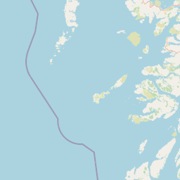
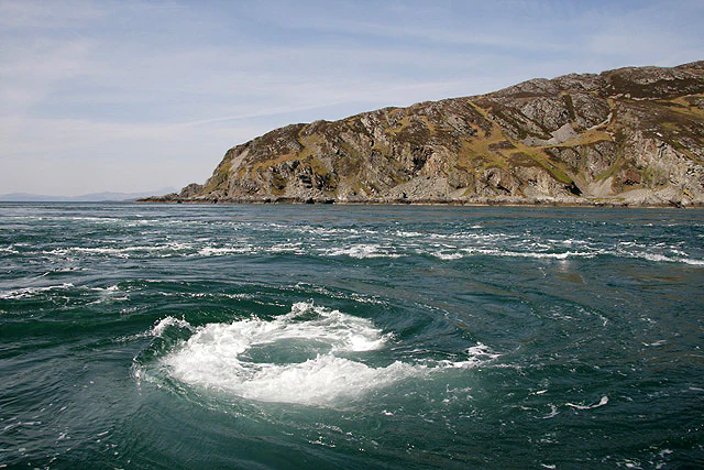
The area is most distinctive for the contrast between the mountainous, moorland-topped island of Scarba and the lower, varied character of the surrounding islets, all set within one of the most tidal seascapes in Europe. It is closely associated with the Gulf of Corryvreckan and its powerful whirlpool, and with the fierce tidal race of Bealach a'Choin Ghlais between Scarba and Lunga. Equally defining is the cultural depth of the Garvellachs, which carry some of Scotland's most ancient ecclesiastical buildings and are described in the original designation report as 'the holy Isles of the Sea'. Combining dramatic landscape, dynamic marine processes, and early Christian heritage gives the area a layered identity that goes well beyond ordinary coastal scenery.
Scarba, Lunga and the Garvellachs National Scenic Area history and protected-area timeline
The history of the national scenic area is part of a wider story of post-war British landscape protection. Following the Second World War, a Scottish committee chaired by Sir Douglas Ramsay considered how best to safeguard scenery worthy of national recognition, publishing a report in 1945 that recommended five areas for an enhanced level of protection. Those original areas were designated as national park direction areas, meaning local planning decisions could be reviewed by central government.
Nearly four decades later, a 1978 review of landscape protection revisited the issue and identified further areas, including islands in the Firth of Lorn, as worthy of similar treatment on the basis of their landscape qualities. In 1981 the direction areas were replaced by the new national scenic area designation, and the Scarba, Lunga and the Garvellachs area, defined on the basis of the 1978 recommendations, was among the new entries. The boundary of the area has remained as it was originally mapped in 1978, although the designation itself was placed on a fresh statutory footing in 2010.
Despite this long-running recognition, the area has no dedicated national park-style authority. Local authorities can produce management strategies, but only the three national scenic areas within Dumfries and Galloway currently have one, meaning the wider governance context remains light-touch compared with Scotland's two national parks.
Scarba, Lunga and the Garvellachs National Scenic Area landscape and geographic character
The landscape of the area is defined by dramatic contrasts between upland and lowland islands and by the dominant presence of water. Scarba is the highest and most imposing landmass, a dark, pyramidal island reaching roughly 449 metres at its summit. Its upper slopes carry open moorland that visually separates it from the green meadows and scrubby islets below, while its eastern flank is surprisingly well-wooded, an unusual feature in such an oceanic setting.
The Garvellachs, lying to the north-east of the group, present an entirely different face. They are sharply angular when seen from the north-east and rise as vertical cliffs on their north-western side, but inwards they soften into green, scrub-clad islets rich in wildflowers among pink quartzose limestone boulders. By contrast, the Slate Islands of Lunga and Belnahua display dark, slatey profiles, with derelict quarries that glisten in sunlight or stand out as bleak, unnatural black shapes against the sky.
Water is never far away and shapes the perception of the whole area. Tidal races rip with visible ferocity between the islands, and the streaming waters and standing waves of the Corryvreckan and Bealach a'Choin Ghlais are themselves recognised as important visual elements of the scene, distinguishing this group from other Argyll island landscapes.
Scarba, Lunga and the Garvellachs National Scenic Area ecosystems, habitats, and plant life
Ecologically, the area combines extreme marine conditions with a mosaic of terrestrial habitats. The strong tidal flows oxygenate the water and produce a varied seabed, and the reefs of the Firth of Lorn are recognised as some of the most diverse reef systems in both the United Kingdom and Europe. Many of the species found there sit at either their northern or southern geographic range limits, increasing the area's conservation interest.
On land, the mosaic ranges from heather-dominated moorland on Scarba's upper slopes and the dark rocky crests around the Garvellachs to pockets of woodland on Scarba's eastern flank and flower-rich maritime turf among the quartzite boulders of the smaller islets. Disturbed ground around the old slate quarries of Lunga and Belnahua adds its own distinct habitat, and the cliffs of the Garvellachs provide dramatic vertical habitat that contrasts sharply with the gentler interior islets.
Scarba, Lunga and the Garvellachs National Scenic Area wildlife and species highlights
The wildlife value of the area is closely tied to its mix of land and sea. The islands of Scarba, Lunga and the Garvellachs, together with neighbouring Jura, are part of a Special Protection Area because of their breeding golden eagles, an association that underlines the importance of these remote landmasses for large raptors. The surrounding Firth of Lorn adds a rich marine fauna in which basking sharks, whales, dolphins, and seals are all recorded.
The reef systems of the Firth form a Special Area of Conservation in their own right, recognising the diversity and biogeographical significance of the species they support. By 2016, additional consideration was being given to extending marine SAC protection around the islands to better safeguard harbour porpoises, indicating that cetacean conservation is now considered a meaningful part of the area's wildlife identity alongside the better-known birds and reefs.
Scarba, Lunga and the Garvellachs National Scenic Area conservation status and protection priorities
The area sits at the intersection of several layers of conservation designation, reflecting the fact that national scenic areas are chosen primarily for scenery but often also hold significant cultural, geological, archaeological, and ecological values. The islands, together with Jura, are protected as a Special Protection Area for breeding golden eagles, while the waters of the Firth of Lorn are designated as a Special Area of Conservation for their highly diverse reef communities.
These overlapping designations confirm that the area's importance extends well beyond visual appeal. The reefs of the Firth of Lorn are considered among the most species-rich in both the UK and Europe, and they lie at biogeographical range limits for several species. The prospect of additional marine protection for harbour porpoises suggests that the conservation framework around the islands is still evolving to capture the significance of the wider seascape.
Scarba, Lunga and the Garvellachs National Scenic Area cultural meaning and human context
The cultural context of the area is most visibly carried by the Garvellachs, described in the original designation report as 'the holy Isles of the Sea' or 'Rough Islands'. These islets hold some of the most ancient ecclesiastical buildings in Scotland, evidence of early Christian presence in the Hebrides that long predates later monastic foundations elsewhere in the country. Their combination of religious antiquity and rugged maritime setting gives them a distinctive role in Scotland's wider early Christian landscape.
The Slate Islands of Lunga and Belnahua add a different, more recent layer of human history. Their dark slatey profiles and the glinting, derelict quarries record an industrial extractive past that contrasts sharply with the ancient religious heritage of the Garvellachs. Together, these strands of early Christian, monastic, and industrial heritage overlap with a wild maritime setting, giving the area a cultural depth that complements its natural significance.
Top sights and standout views in Scarba, Lunga and the Garvellachs National Scenic Area
Among the strongest points of distinction in this national scenic area are the Corryvreckan whirlpool and the Bealach a'Choin Ghlais channel, two of the most visually dramatic tidal features in Britain. Equally notable is the contrast between Scarba's moorland-heathed summit and wooded eastern side and the gentler, flower-rich terrain of the Garvellachs, an unusual juxtaposition for a small island group.
The area's claim to attention is strengthened by the layered cultural and natural heritage: some of Scotland's oldest ecclesiastical sites on the Garvellachs, the slate quarry remains of Lunga and Belnahua, and overlapping European designations for golden eagle habitat and exceptionally diverse marine reefs. Few Scottish scenic areas combine such a compact package of scenery, wildlife, and early history.
Best time to visit Scarba, Lunga and the Garvellachs National Scenic Area
The character of a visit is shaped strongly by Scotland's maritime climate and by tides rather than by any narrow seasonal window. Spring and summer typically bring longer daylight, more settled conditions for boat access, and more flowering display among the maritime turf of the Garvellachs, while autumn and winter can emphasise the dramatic quality of storms against the dark profiles of the islands. Summer is generally the most conducive period for wildlife observation and for appreciating the area's mix of land and seascape, but visitors should be mindful that tidal conditions in and around the Corryvreckan and Bealach a'Choin Ghlais are powerful year-round and require local knowledge and respect.