Mori Atlas logo
Nature reserveSchulterbachtal

Understanding the mapped terrain, stream corridors, and wet meadow boundaries of this Bavarian protected landscape

Schulterbachtal Nature Reserve: A Detailed Geographic Overview of the Steigerwald Wetland Complex

(Naturschutzgebiet Schulterbachtal)

Schulterbachtal functions as a critical wetland refuge within the northern Steigerwald region of Bavaria. This nature reserve, centered on the natural course of the Schulterbach stream, preserves a mosaic of rare wet grasslands, black alder forests, and ash woodland corridors. The site provides a distinct look at how small, hydrologically intact meadow valleys contribute to regional biodiversity and the broader Natura 2000 conservation network.

wet meadow valleynature reservebrook habitatSteigerwaldLower Franconiablack alder woodland

Schulterbachtal

Nature reserve

Park overview

Structured park overview, official facts, and landscape profile for Schulterbachtal Nature Reserve

Schulterbachtal Nature Reserve park facts, protected area profile, and essential visitor context

Review the core facts for Schulterbachtal Nature Reserve, including designation, size, terrain, visitor scale, habitats, and operating context in one park-focused overview.

About Schulterbachtal Nature Reserve

Schulterbachtal is a small but ecologically focused nature reserve set into the western flank of the Steigerwald, a prominent low mountain range that extends across northern Bavaria. The valley is a textbook example of the wet meadow valleys that once threaded through the region, and its protected status since 1990 has allowed the natural hydrology, grassland mosaic, and brook forests to be maintained as a coherent whole.

The reserve lies in the municipality of Rauhenebrach in the Haßberge district of Lower Franconia, roughly between the villages of Fatschenbrunn to the north and Theinheim to the south. Its 34 hectares occupy a narrow, stream-cut valley between approximately 315 and 381 meters in elevation, giving the area a character that is sheltered yet varied. The Schulterbach, which gives the valley its name, winds through the protected land as a tributary of the Rauhe Ebrach, and its waters are the central organizing feature of the landscape.

Ecologically, Schulterbachtal is best understood as part of the broader Steigerwald system. It falls within the Natura 2000 site known as Buchenwälder und Wiesentäler des Nordsteigerwalds, a designation that recognizes the area's beech forests and meadow valleys as a European conservation priority. At the same time, it overlaps with the Oberer Steigerwald bird protection area, so the reserve contributes to both habitat and bird conservation goals. Beyond these designations, the valley belongs to the Steigerwald Nature Park, which frames the protected landscape within a wider network of recreation, forestry, and conservation land use.

What distinguishes Schulterbachtal from many of its neighbors is the deliberate preservation of an entire valley as a working mosaic of stream, wet grassland, and alder-ash forest. Rather than focusing on a single habitat type, the management plan aims to keep the traditional cultural landscape alive: open meadows for butterflies and other invertebrates will continue to be managed for, the stream is left to follow its natural course, and the forest stands are encouraged to retain their native tree composition. The valley therefore functions as a compact but representative model of the wet, brook-bound landscapes of the northern Steigerwald, and as a quiet but important contributor to regional biodiversity.

Quick facts and research context for Schulterbachtal Nature Reserve

Schulterbachtal is a German nature reserve (Naturschutzgebiet) in the Steigerwald, a wooded low mountain range in northern Bavaria. It lies within the municipality of Rauhenebrach in the Haßberge district of Lower Franconia, administered by the district authority. The reserve was formally designated in 1990 and covers about 34 hectares at elevations between 315 and 381 meters above sea level.

In management terms it is classified under IUCN Category IV as a habitat and species management area, and it is fully integrated into the EU Natura 2000 network. The valley is part of the larger Fauna-Flora-Habitat site known as Buchenwälder und Wiesentäler des Nordsteigerwalds and also falls within the Oberer Steigerwald bird protection area. The Schulterbach stream, a tributary of the Rauhe Ebrach, runs through the protected landscape.

Protection and recognition

Examine official protected area records and designated status details.

Schulterbachtal Protection Status and International Recognition Data

Schulterbachtal brings together documented protection status, designation history, and management scope based on global conservation records. Conservation researchers review these authoritative protected area metrics to understand regional environmental governance frameworks.

Protection details

WDPA ID
165471
Park context

Deeper park guide and search-rich context for Schulterbachtal Nature Reserve

Schulterbachtal Nature Reserve history, landscape, wildlife, and travel context

Explore Schulterbachtal Nature Reserve through its history, landscape character, ecosystems, wildlife, conservation priorities, cultural context, and seasonal travel timing in a structured park guide built for atlas discovery and search intent.

Why Schulterbachtal Nature Reserve stands out

Schulterbachtal is known above all for its well-developed wet meadow valley in the Steigerwald, where a near-natural stream, diverse grassland communities, and black alder and ash forests form an unusually coherent wetland complex. The reserve is valued as a refuge for grassland-dependent species such as the large blue butterfly (Heller Wiesenknopf-Ameisenbläuling) and for brook fauna including the native noble crayfish (Steinkrebs) and brook trout. It is also recognized as a building block of the larger Steigerwald conservation landscape, linking into the Natura 2000 habitats of the northern Steigerwald. For visitors and ecologists alike, the valley illustrates how small, carefully managed cultural landscapes can still sustain meaningful biodiversity in a region dominated by beech forest and modern forestry.
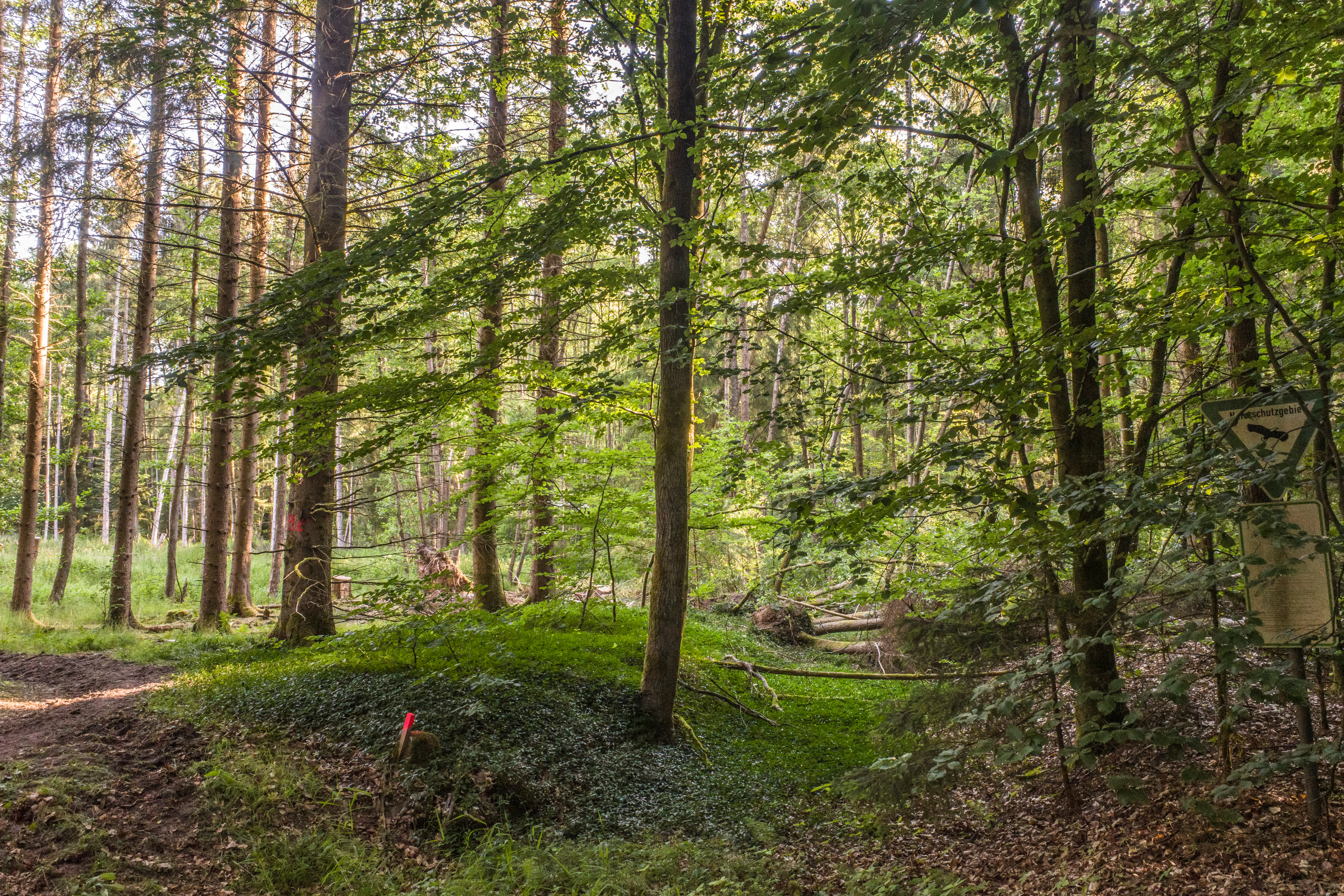
A view into a lush green forest with tall trees, dappled sunlight, and a small trail sign on the right side.
A shaded forest path within the Schulterbachtal nature reserve.

Schulterbachtal Nature Reserve history and protected-area timeline

Schulterbachtal was formally designated as a nature reserve in 1990, making it a relatively late addition to the network of protected areas in the Haßberge district but part of a growing recognition of the ecological value of the Steigerwald's small meadow valleys. The designation was driven by the valley's transformation into a stable wetland complex worth preserving in its own right, rather than simply as an adjunct to the surrounding beech forest landscape.

Over subsequent decades, the reserve became embedded in larger European conservation frameworks. It was incorporated into the Habitat-Flora-Fauna (FFH) site Buchenwälder und Wiesentäler des Nordsteigerwalds, which protects the broader pattern of beech forests and meadow valleys across the northern Steigerwald. It also falls within the Oberer Steigerwald bird protection area, ensuring that its open and forested habitats are considered in the management of the region's avifauna.

More recently, management planning for the FFH area has structured ongoing monitoring and conservation work in the reserve, including targeted surveys of aquatic species, butterflies, and amphibians, and assessments of habitat structure and population status. Although the land itself is small, the valley's long-term viability is now supported by regional, federal, and European level instruments rather than by local protection alone.

Schulterbachtal Nature Reserve landscape and geographic character

The landscape of Schulterbachtal is shaped above all by the valley itself. The reserve follows the course of the Schulterbach where it has cut a gently sloping trough into the western flank of the Steigerwald, producing a sheltered corridor of wetland, grassland, and wet forest that contrasts with the broader wooded high ground around it. Elevations within the protected area range from roughly 315 meters along the lower valley to about 381 meters on its higher edges, giving the site a modest but noticeable relief.

The terrain is not dramatic. There are no cliffs, screes, or obvious rock outcrops; instead the valley floor and lower slopes are given over to wet meadows, sedge- and rush-dominated flushes, larger sedge stands, and pockets of open water. The valley sides rise gently into the surrounding Steigerwald forest, with the transition marked by a thin and ecologically important belt of black alder and ash woodland that lines the brook. This gradient from open wet ground to wet forest to dry forest is one of the defining features of the site.

The stream itself is the most consistent landscape element. The Schulterbach runs through the reserve in a largely natural course, providing the hydrological backbone that keeps the meadows wet, supports the alder-ash forests, and sustains the brook fauna on which the reserve places such strong conservation weight. Even in a region known for its forests, the valley therefore reads as a distinct, water-defined feature rather than as a continuation of the woodlands around it.

Schulterbachtal Nature Reserve ecosystems, habitats, and plant life

Ecologically, Schulterbachtal represents a compact fragment of the wet, meadow-and-brock landscape that historically characterized the Steigerwald. Its habitats form a tight mosaic: near-natural brook corridors, stands of black alder and ash woodland, sedge- and rush-rich wet meadows, larger sedge beds outside the open water edges, species-rich extensive grassland, and small patches of mat-grass swards along the forest margins where open and wooded habitats meet.

The grasslands of the valley are an essential ecological element. They include habitat types that qualify as extensive species-rich meadows in the European sense, with various greenland communities present in different forms. Among the more unusual features are small patches of Borstgrasrasen, mat-grass swards that survive in the transitional zones between forest and meadow and indicate long continuity of low-intensity management. These swards are rare regionally and give the valley an extra conservation dimension beyond its core wetland character.

The wet forest communities are equally important. Black alder and ash forests along the brook are explicitly protected as part of the reserve's purpose, with management aimed at preserving the typical species composition of these stands. Together with the wet meadows, the sedge beds, and the open water surfaces, these forest patches make the valley a functional wetland complex rather than a simple collection of habitats. The overall picture is one of a small but unusually complete example of the kind of cultural-wetland landscape that once stretched across much of the northern Steigerwald.

Schulterbachtal Nature Reserve wildlife and species highlights

The wildlife interest of Schulterbachtal is closely tied to its combination of wet meadows, flowing water, and alder-ash forest. The reserve has been surveyed as part of the management planning for the surrounding FFH area, and a number of species of conservation interest are documented within its boundaries.

In the meadows, the large blue butterfly (Heller Wiesenknopf-Ameisenbläuling) is one of the flagship species, tied closely to the presence of suitable grassland habitats with the right host plants and management conditions. Its continued presence is treated as a key indicator of the quality of the wet meadow mosaic. In the brook and along its banks, the noble crayfish (Steinkrebs) is another important target, with documented records in the reserve and ongoing attention to the condition of its habitat and populations. Although the brook lamprey (Bachneunauge) has not yet been recorded here, parts of the stream are considered potentially suitable habitat for the species, which is monitored across the FFH area as a whole.

Fish species recorded in the stream include brown trout (Bachforelle), the Pseudorasbor parva (Blaubandbärbling), the Mühlkoppe, and roach (Rotauge), reflecting a mix of native and more generalist stream fish. Among amphibians, the crested newt (Kammmolch) has been confirmed in the reserve, adding to the wetland fauna. Combined with the broader bird interest of the surrounding Oberer Steigerwald bird protection area, this means the valley supports a meaningful cross-section of wetland, brook, and woodland fauna within a very small footprint.

Schulterbachtal Nature Reserve conservation status and protection priorities

Schulterbachtal is a conservation area in two complementary senses: it is a formally designated nature reserve under German law, and it is part of the European Natura 2000 network. Under the IUCN system it is classified as a Category IV habitat and species management area, a status reserved for sites where active management is essential to maintain biodiversity values.

The conservation logic of the reserve is to preserve a representative Steigerwald meadow valley in a near-natural state and to develop it further as a stable wetland complex. Three priorities dominate: keeping the brook in its natural state, including the specific fauna that depends on it; sustaining the diverse mosaic of grasslands, from extensive managed meadows to small mat-grass swards; and protecting the black alder and ash forests that fringe the stream. Together these formal goals aim at conserving biodiversity in its entirety, both flora and fauna, rather than focusing on a single species or habitat.

The reserve's values are reinforced by its inclusion in the Fauna-Flora-Habitat site Buchenwälder und Wiesentäler des Nordsteigerwalds and the Oberer Steigerwald bird protection area, which broaden its conservation significance beyond its own borders. Management planning for the FFH area structures ongoing monitoring of habitats and populations, while the threats the site faces remain familiar in similar cultural landscapes: eutrophication, loss of open land to shrub and tree encroachment, spread of ruderal and non-native plants, soil compaction, changes in water levels, long-term abandonment, and the encroachment of non-native tree species.

Schulterbachtal Nature Reserve cultural meaning and human context

Schulterbachtal is a strong example of the traditional cultural landscape of the northern Steigerwald, where generations of meadow, brook, and woodland management shaped the valleys well before any formal protection existed. The wet meadows along the Schulterbach are a continuation of that local farming and land-use heritage, and their ability to remain species-rich and ecologically functional depends on ongoing low-intensity management such as late mowing or grazing.

The reserve is embedded in a region with a long tradition of small-scale, closely settled agricultural communities, including the villages of Fatschenbrunn, Theinheim, Falsbrunn, Fabrikschleichach, Karbach, and Untersteinbach that frame the valley. Although the protected area is small, it preserves a fragment of the wider Steigerwald cultural landscape, in which narrow meadow valleys alternating with beech forest are a defining element. Its identity is therefore as much a product of historical human stewardship as it is of natural processes, and maintaining the valley's meadows is in part a matter of sustaining that cultural-ecological relationship.

Top sights and standout views in Schulterbachtal Nature Reserve

Schulterbachtal stands out for integrating a single valley into a coherent wetland complex: a near-natural brook, a mosaic of wet grasslands, and black alder and ash forests all in one compact site. It is also notable for how clearly it illustrates the conservation strategy of the Steigerwald on a small scale: keeping open meadows deliberately managed, leaving the brook undisturbed, and protecting the wet forest edges that link everything together.

The reserve's integration into the Natura 2000 network, including both the beech-forests and meadow-valleys Habitat-Flora-Fauna site and the Oberer Steigerwald bird protection area, makes it a small but well-networked element of the larger European conservation landscape, and a good example of how even modest reserves can carry substantial biodiversity weight.

Best time to visit Schulterbachtal Nature Reserve

Schulterbachtal is best experienced in late spring and summer, when the wet meadows are in full growth and the grassland mosaic is most apparent. Early to mid summer is particularly good for seeing the meadows as a flowering complex, while butterflies and other grassland invertebrates are most active in warm weather along the open valley edges. The surrounding beech forests and brook corridors provide cooler, shadier conditions throughout the same period. In late autumn and winter, the reserve's structure remains visible as a clear valley cutting into the forest, but the wet meadows and forest understorey are quieter and the color palette shifts to browns and greens, making this a calmer, more contemplative time to observe the site's landscape form.

Monthly climate preview

Track measured monthly averages across the representative park coordinate in Landkreis Haßberge

Schulterbachtal Climate Normals, Long-Term Temperature and Precipitation Preview

Schulterbachtal records multi-year temperature ranges from sub-zero winter minimums to warm summer maximums alongside steady daily precipitation rates. Opening the complete monthly climate dataset reveals the full twelve-month progression of temperature and moisture normals.
Annual mean9 °C
-1 °C19 °C
Jan-1°
Feb
Mar
Apr
May13°
Jun17°
Jul19°
Aug19°
Sep14°
Oct
Nov
Dec
Warmest month
July

19.4 °C

Coolest month
January

-1.2 °C

Wettest month
July

2.5 mm/day

Driest month
April

1.3 mm/day

Park location guide

Geography guide, regional context, and park location map for Schulterbachtal Nature Reserve

Schulterbachtal Nature Reserve park geography, regions, and map view in Germany

Understand where Schulterbachtal Nature Reserve sits in Germany through a broader geographic reading of the surrounding landscape, nearby location context, and its mapped position within the national park landscape.

How Schulterbachtal Nature Reserve fits into Germany

Germany is a federal republic in Western and Central Europe with a population of over 83 million across sixteen constituent states. It is Europe's largest economy by nominal GDP and a major global exporter and importer. The capital is Berlin, and the country borders Denmark, Poland, Czech Republic, Austria, Switzerland, France, Luxembourg, Belgium, and the Netherlands.

Wider geography shaping Schulterbachtal Nature Reserve in Germany

Germany is located in Western and Central Europe, spanning 357,022 km². It borders Denmark to the north, Poland and the Czech Republic to the east, Austria and Switzerland to the south, and France, Luxembourg, Belgium, and the Netherlands to the west. The country has coastlines on the Baltic Sea and North Sea to the north, with the Alps located in the southern region.

Map view of Schulterbachtal Nature Reserve

Use this park location map to pinpoint Schulterbachtal Nature Reserve in Germany, understand its exact geographic position, and read its mapped placement within the surrounding landscape more clearly.

Pigeon | © OpenStreetMap contributors

Location context for Schulterbachtal Nature Reserve

Landkreis Haßberge

Explore the wet meadow valley, stream habitats, and forest edges of the Steigerwald reserve.

Schulterbachtal Photos and Landscape Scenery: Protected Area Visual Reference

Photographic records reveal the distinct valley terrain, near natural brook course, and diverse grassland habitats defining Schulterbachtal. Visual exploration clarifies the protected area character, regional ecology, and wetland structure across the protected landscape.

A view into a lush green forest with tall trees, dappled sunlight, and a small trail sign on the right side.

Park atlas

Compare regional valley reserves, wet meadows, and nearby conservation areas.

Exploring Parks Near Schulterbachtal and Surrounding Protected Landscapes

Browse other protected areas near Schulterbachtal to examine similar meadow valleys and wetland habitats across the surrounding regional terrain. Comparing these adjacent conservation landscapes provides broader context on the low mountain ecosystems of northern Bavaria.
Nature reserveLandkreis Haßberge
About 5.4 km away#1 closest

Northwest

Naturwald Wotansborn: A Protected Old-Growth Beech Reserve in the Heart of the Steigerwald

Ancient forest geography within the Haßberge district

Naturwald Wotansborn is a protected woodland enclave that preserves centuries-old beech trees and high concentrations of deadwood habitat. Located in the Steigerwald of Landkreis Haßberge, this reserve offers a window into natural forest cycles, housing the historic Wotansborn spring and a vital corridor for amphibian life along the Erlesbach stream.

Area
0.033 km²
Established
2020
IUCN
IV
Relief
Upland
A soft watercolor painting of a rolling forested landscape with green hills and trees on a white background.
Nature reserveBayern
About 8.1 km away#2 closest

Northwest

Naturwald Knetzberge-Böhlgrund Nature Reserve and Steigerwald Forest Geography

A mapped overview of protected broadleaf forests in Lower Franconia.

Spanning over 800 hectares, Naturwald Knetzberge-Böhlgrund is a major protected forest entity in the Steigerwald that integrates mature stands, deadwood habitats, and steep valley topographies. This area offers a unique perspective on natural forest succession and ecological preservation within the German landscape, marked by its distinct sandstone ridges and high biodiversity.

Area
8.474 km²
Established
2020
Relief
Mountain
Climate
Temperate
Watercolor painting of a forest landscape with a grassy clearing and distant hills, rendered in soft green and pink tones.
Nature reserveGermany
About 9.7 km away#3 closest

Southwest

Naturwald Waldhaus: Geographic Mapping of an Ancient Beech Reserve in Steigerwald, Bavaria

Protected natural woodland and forest biodiversity in northern Germany.

Naturwald Waldhaus stands as a prime example of a protected forest in the Steigerwald, recognized for its exceptionally old beech stands and documented saproxylic beetle populations. This nature reserve provides essential ecological continuity within the Bamberg district, representing a rare, undisturbed woodland landscape that serves as a cornerstone for forest research in southern Germany.

Area
1.062 km²
Established
1978
Relief
Upland
Climate
Temperate
Watercolor painting showing rolling green hills, trees in the midground, and purple-tinted mountains in the background against a white backdrop.
Nature reservePrichsenstadt
About 15 km away#4 closest

Southwest

Naturwald Krackentännig Nature Reserve: A Protected Forest Landscape in Northern Bavaria

Geography of the Steigerwaldvorland and Gänsseegraben valley floor

Situated near Prichsenstadt, Naturwald Krackentännig acts as a refuge for ash and alder trees that thrive in the moist soils of the Lower Franconian countryside. This nature reserve provides a critical example of undisturbed forest development, showcasing a specialized ecosystem within the rolling hills of the Steigerwaldvorland and a commitment to preserving small-scale woodland habitats.

Area
0.026 km²
Established
2021
Relief
Lowland
Scope
Terrestrial
A watercolor painting showing a panoramic landscape with light green hills, tall slender trees in the foreground, and soft washes of color depicting a natural forest scene.
Nature reserveBavaria
About 17 km away#5 closest

South

Naturwald Schlag Nature Reserve: Geographic Atlas and Protected Forest Context in Bavaria

A dedicated site for natural forest development and regional conservation mapping

Naturwald Schlag serves as a vital case study for non-intervention forestry in the Steigerwald region of Upper Franconia. Located near the locality of Heuchelheim, this reserve protects a mature stand of pine, beech, and oak. MoriAtlas provides a clear view of its formal designation and geographic position within the broader Bavarian natural forest network.

Area
0.008 km²
Established
2021
Relief
Upland
Climate
Temperate
Watercolor painting of a gentle valley landscape featuring soft green hills, mixed deciduous and coniferous trees, and a winding stream.
Nature reserveOberfranken
About 23 km away#6 closest

East

Naturwald Wolfsruhe Protected Forest Reserve: An Oberfranken Geography and Atlas Overview

Analyzing the forest composition and Keuper escarpment landscape

Naturwald Wolfsruhe is a protected nature reserve in Oberfranken that showcases a unique forest ecosystem shaped by former coppice-with-standards management. This site offers valuable insight into the biodiversity of the Franconian Keuper-Lias region, where pedunculate oak stands and varied soil substrates create a distinct natural landscape south of Bamberg.

Area
0.465 km²
Established
1978
IUCN
IV
Relief
Lowland
A horizontal watercolor painting showing a soft, layered forest landscape with coniferous trees in the foreground and rolling mountains in the distance.
Nature reserveGermany
About 24 km away#7 closest

West

Naturwaldreservat Riedholz: Protected Woodland and Floodplain Forest in Lower Franconia

Mapped natural forest reserves in the Steigerwaldvorland region

Naturwaldreservat Riedholz represents a pioneering municipal initiative in Bavaria to preserve lowland forest processes permanently. Located near Grettstadt and Schwebheim, this protected woodland preserves moisture-loving vegetation and relict oaks, acting as a vital ecological anchor within the agricultural landscape of the Schweinfurt Basin.

Area
0.11 km²
Established
1999
Relief
Lowland
Scope
Terrestrial
A horizontal watercolor painting showing a soft, abstract landscape with rolling green fields, a winding pale river, and a light-filled line of trees in the distance.
Nature reserveBayern
About 24 km away#8 closest

East

Naturwald Wasserwand Nature Reserve: Mapped Protected Forests of Upper Franconia, Bayern

An undisturbed oak and beech woodland within the Bruderwald forest plateau.

Naturwald Wasserwand represents a core node in the protected forest network surrounding Bamberg, Bayern. This nature reserve, spanning 30 hectares, focuses on preserving near-natural forest processes through the exclusion of active timber management. The site provides a unique opportunity to study the development of mature broadleaf stands in a transitional zone between suburban expansion and the rural Franconian countryside.

Area
0.291 km²
Established
2022
IUCN
IV
Relief
Lowland

Common questions about visiting, size, designation, and location context for Schulterbachtal Nature Reserve

Schulterbachtal Nature Reserve FAQs for park facts, access, geography, and protected area context

Find quick answers about Schulterbachtal Nature Reserve, including protected-area facts, park geography, trail and visitor context, and how the park fits into its surrounding country and regional landscape.
MoriAtlas Explorer

Continue Your Protected Areas Search Across the Global Atlas

Deepen your exploration by continuing the structured search for national parks and protected areas worldwide. Utilize the comprehensive filtering capabilities to compare different conservation landscapes and refine your understanding of global park geography. Discover more about the distribution and characteristics of protected natural areas.

Global natural geography