
Mori Atlas logo
Nature reserveSeelbachs- und Eulenbruchswald

A significant mixed deciduous forest complex within the Rhenish Slate Mountains of Germany

Seelbachs- und Eulenbruchswald Nature Reserve: Geographic Profile and Protected Woodland Boundaries

(Naturschutzgebiet Seelbachs- und Eulenbruchswald)

Seelbachs- und Eulenbruchswald represents a vital nature reserve located near Freudenberg in the Nordrhein-Westfalen region. This protected area preserves one of the most expansive contiguous mixed deciduous forests in the Siegerland, characterized by old-growth beech stands and diverse riparian corridors. Through mapping its terrain, one can observe a complex mosaic of spring-fed brooks, wet meadows, and forest ridges that serve as a crucial habitat for European bird species.

deciduous forestbeech forestmixed woodlandnature reserveFFH sitewoodpecker habitat
An artistic illustration featuring geometric shapes of pink, yellow, and green, depicting a mountain valley with a waterfall cascading down a cliff into a river, with evergreen trees in the foreground and a sun in the background.

Seelbachs- und Eulenbruchswald

Nature reserve

Park overview

Structured park overview, official facts, and landscape profile for Seelbachs- und Eulenbruchswald

Seelbachs- und Eulenbruchswald park facts, protected area profile, and essential visitor context

Review the core facts for Seelbachs- und Eulenbruchswald, including designation, size, terrain, visitor scale, habitats, and operating context in one park-focused overview.

About Seelbachs- und Eulenbruchswald

Seelbachs- und Eulenbruchswald is a forest-focused nature reserve in the Siegerland region of North Rhine-Westphalia, Germany. Located west of the town of Freudenberg, it sits within the natural region of the Rhenish Slate Mountains, a landscape of rolling ridges and valleys shaped by ancient Paleozoic rocks. The climate here is Atlantic-influenced, characterized by frequent cloud cover and significant rainfall, conditions that have long supported the development of moist, structurally rich deciduous forests.

The reserve covers around 167 hectares across two separate areas and protects one of the largest contiguous mixed deciduous forests in the Freudenberg area. Its size is itself an ecological asset, allowing natural processes such as natural regeneration, deadwood accumulation, and species turnover to operate across meaningful spatial scales. This makes the area more than just a collection of forest patches; it is a coherent ecological unit in a region where forest fragmentation is otherwise common.

Old European beech (Fagus sylvatica) stands form the backbone of the reserve, often with a strongly layered understory that reflects the original composition of native woodland. Scattered older specimens of spruce, pedunculate oak, and sessile oak add structural variety, while accompanying tree species include silver birch, rowan, willow, aspen, and wild cherry. In some sections, denser stands of non-native conifers such as Douglas fir and Norway spruce occur, and these are targeted for gradual conversion into more natural mixed deciduous communities.

A defining feature of the reserve is the abundance of deadwood, both standing and fallen, which supports communities of fungi, insects, and cavity-nesting birds. Woodpeckers, in particular, find essential feeding and nesting resources in this deadwood. The reserve also contains numerous small brooks, spring areas, and watercourses lined with alder and sycamore maple, contributing additional moisture-loving habitats. Management aims to maintain and enhance this structural richness while shifting the species composition toward more natural, site-appropriate woodland.

Quick facts and research context for Seelbachs- und Eulenbruchswald

Seelbachs- und Eulenbruchswald is a nature reserve of about 167 hectares in two parcels, situated west of Freudenberg in the Siegerland, within the Rhenish Slate Mountains of North Rhine-Westphalia, Germany. A portion of the area is designated as an FFH (Habitat Directive) site under the code DE-5013-301, tying its protection to European nature conservation frameworks.

The reserve centers on a large, structurally diverse mixed deciduous forest, with old European beech (Fagus sylvatica) stands as a defining element. It also contains numerous small streams, spring areas, alder-and sycamore-lined watercourses, and small wet meadows with marsh marigold. The climate of the region is Atlantic-influenced, cloudy and rainy, with a mean annual temperature of roughly 8 degrees Celsius.

Protection and recognition

Examining documented protection scope and management parameters

Seelbachs- und Eulenbruchswald Protection Status and Recognition Records

Seelbachs- und Eulenbruchswald maintains a defined terrestrial protection framework within its regional conservation landscape. Structured records outline the official designation scope and international recognition status associated with the protected terrain.

Protection details

Protection scope
Terrestrial
Transboundary protection
No
Park context

Deeper park guide and search-rich context for Seelbachs- und Eulenbruchswald

Seelbachs- und Eulenbruchswald history, landscape, wildlife, and travel context

Explore Seelbachs- und Eulenbruchswald through its history, landscape character, ecosystems, wildlife, conservation priorities, cultural context, and seasonal travel timing in a structured park guide built for atlas discovery and search intent.

Why Seelbachs- und Eulenbruchswald stands out

Seelbachs- und Eulenbruchswald is best known as one of the largest contiguous mixed deciduous forests in the Freudenberg area, dominated by old-growth beech with naturally layered understory. It is equally recognized as a stronghold for several rare woodpecker species and other woodland birds of conservation concern, with black woodpecker, middle-spotted woodpecker, grey-headed woodpecker, and red kite all noted as key species. The reserve also stands out for its combination of protected habitats at the European level. It unites acid beech forests (Luzulo-Fagenion), alder-ash floodplain forests, spring-fed brook corridors, and marsh marigold wet meadows in a single protected area. This combination of forest, stream, and meadow habitats in a relatively compact area makes it a representative example of central European low mountain woodland.
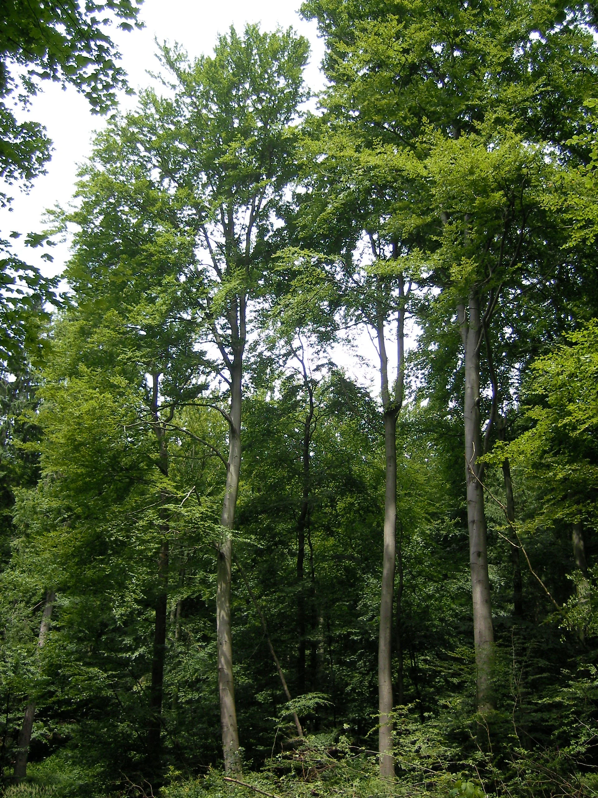
A group of tall, mature European Beech trees with light grey bark and dense green foliage in a forest setting.
European Beech trees in Seelbachs- und Eulenbruchswald.

Seelbachs- und Eulenbruchswald history and protected-area timeline

The reserve was formally designated to preserve and restore the characteristic communities of a large, connected forest landscape. Its establishment reflects the broader German and European movement to safeguard representative woodland ecosystems, particularly acid beech forest and alder-ash floodplain forest, through the national Naturschutzgebiet framework and the EU Habitats Directive (FFH).

Protected status was driven by the presence of habitats and species of community interest. The site overlaps with the FFH area DE-5013-301, focusing particularly on acidophile beech forests of the Luzulo-Fagenion type, alder-ash gallery forests along natural brook courses, spring-fed wetland zones, and small wet meadows with marsh marigold. Species of community interest highlighted in the designation include the middle-spotted woodpecker, black woodpecker, grey-headed woodpecker, and red kite.

Over time, the reserve's management direction has emphasized near-natural forestry, with the explicit goal of gradually transitioning non-native conifer stands into mixed deciduous woodland and limiting spruce to isolated individuals. Detailed landscape planning by Kreis Siegen-Wittgenstein has shaped this approach, integrating the reserve into the wider network of protected areas within the district.

Seelbachs- und Eulenbruchswald landscape and geographic character

The reserve lies within the Rhenish Slate Mountains, in the Siegerland natural region west of Freudenberg. The terrain reflects the character of the central German low mountain belt: incised valleys, forested ridges, and a mosaic of small watercourses. Roads L 562 and K 21 cut through the area, separating it into two main forest sections that nonetheless remain functionally connected as a single forest complex.

Within this broader setting, the reserve is defined by its forested surface rather than dramatic relief. Sloping, forested hillsides carry old beech stands, while the lower-lying stream corridors create cooler, moister microhabitats. Numerous small brooks, seepage areas, and spring-fed flushes break up the forest matrix, sometimes opening into small wet meadows where marsh marigolds bloom in spring. These meadow openings are a small but important counterpoint to the surrounding forest, contributing openness and edge habitat to an otherwise wooded landscape.
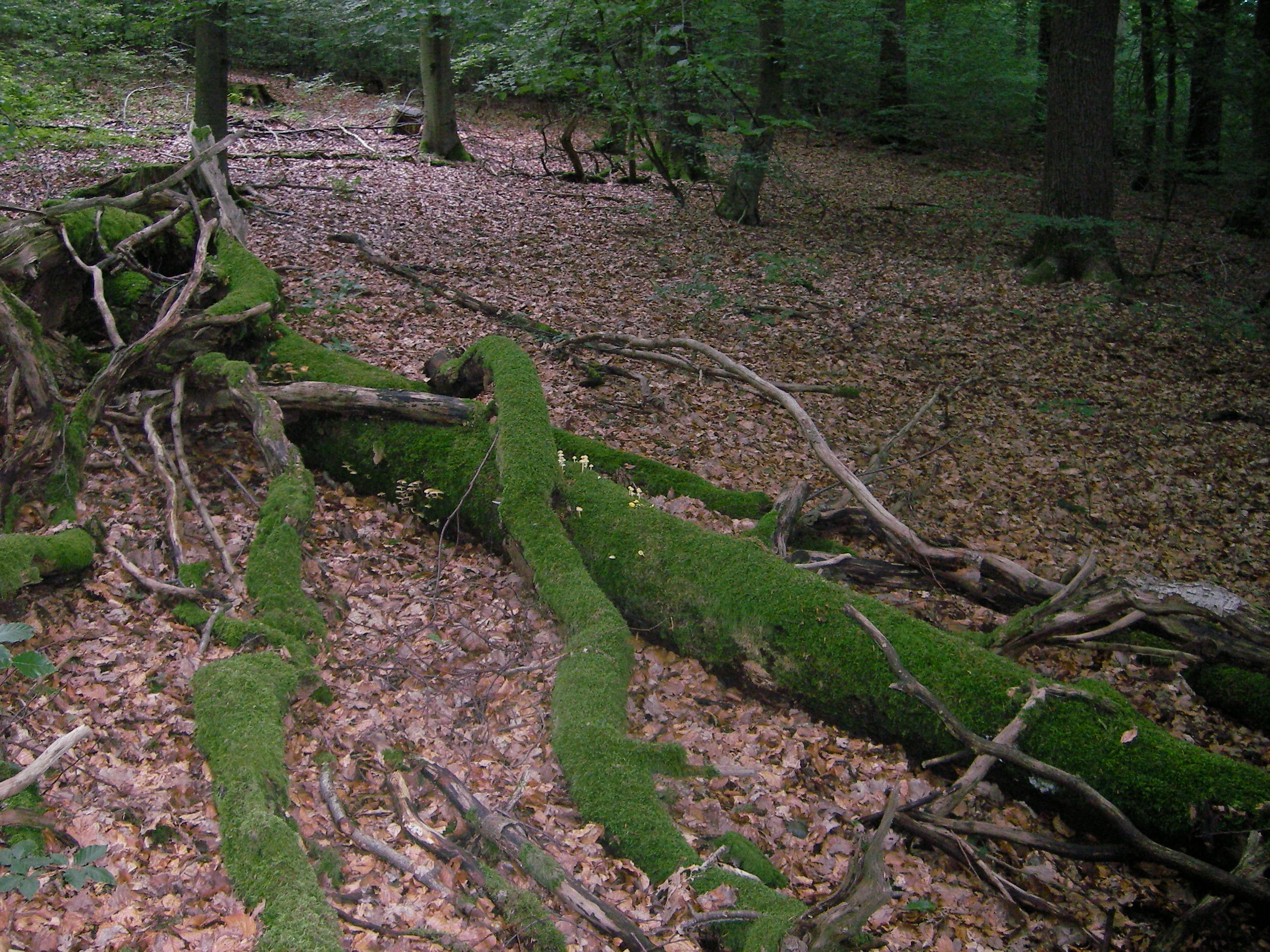
A large mossy fallen tree trunk lying on the forest floor, covered in green moss and surrounded by fallen leaves and beech trees.
A moss-covered fallen tree in the Seelbachs- und Eulenbruchswald nature reserve.

Seelbachs- und Eulenbruchswald ecosystems, habitats, and plant life

Ecologically, Seelbachs- und Eulenbruchswald is defined by a layered mosaic of habitats rather than a single dominant type. The core of the reserve is acid beech forest (Luzulo-Fagenion), an FFH-listed habitat type found in more nutrient-poor, often steeper, and slightly acidic soils. These beech stands are generally well-structured, with old trees, abundant natural regeneration, and a diverse understory that mirrors what would have existed under pre-management forest conditions.

Around the streams and spring lines, habitat character shifts to a richer, more moisture-loving assemblage. Alder-ash gallery forests with a softwood fringe occupy the immediate brook corridors, while small marshy clearings support Calthion wet meadows, dominated by marsh marigold (Caltha palustris). These riparian and wetland features are integrated into the forest matrix, creating fine-scale transitions between dry woodland, moist slope forest, and open wet meadow. Together, this combination of habitats supports a wide range of ecological niches within a compact area.

Seelbachs- und Eulenbruchswald wildlife and species highlights

The reserve is strongly associated with its birdlife, which has played a central role in justifying and shaping its protected status. Woodpeckers are particularly prominent: the black woodpecker, middle-spotted woodpecker, lesser spotted woodpecker, great spotted woodpecker, grey-headed woodpecker, and green woodpecker all occur. Of these, the middle-spotted, black, and grey-headed woodpeckers, together with the red kite, are considered species of community interest under the EU Habitats Directive and were specifically considered during the reserve's designation.

Other characteristic woodland birds include the Eurasian pygmy owl, the long-eared owl, the Eurasian woodcock, and the western jackdaw. The abundance of standing and fallen deadwood underpins much of this avifauna, providing nesting cavities, drumming sites, and rich invertebrate prey. Amphibians such as the common toad, fire salamander, and common frog also occur, especially around the wetter brook and spring areas. Among insects, notable butterflies include the purple emperor and the silver-washed fritillary, both of which depend on the structural continuity of mature deciduous woodland.

Seelbachs- und Eulenbruchswald conservation status and protection priorities

Seelbachs- und Eulenbruchswald holds conservation significance at multiple levels. Within North Rhine-Westphalia, it is one of the more substantial mixed deciduous forest reserves in the Siegerland region, providing protection for old beech stands and the ecological processes, such as natural regeneration and deadwood dynamics, that underpin them. At the European level, its overlap with the FFH site DE-5013-301 links it to the Natura 2000 network, aligning national protection with broader EU biodiversity commitments.

The reserve's conservation targets explicitly include the maintenance of well-structured, near-natural, layered beech forests with rich herb layers and active regeneration; the preservation and recovery of declining and highly endangered near-natural brook sections with alder-ash floodplain woodland; the protection of spring and seepage zones; and the conservation of marsh marigold wet meadows. Protection of woodpecker populations, especially the middle-spotted, black, and grey-headed woodpecker, as well as the red kite, is a central conservation objective.

Active management focuses on near-natural forestry, gradual replacement of non-native conifers with site-appropriate broadleaf species, and control of ungulate populations to reduce browsing and bark-peeling damage that would otherwise undermine natural regeneration. Open meadow habitats are also maintained through targeted mowing or grazing to prevent them from being lost to scrub encroachment.

Top sights and standout views in Seelbachs- und Eulenbruchswald

Among the reserve's most distinctive features is its sheer scale as one of the largest contiguous mixed deciduous forests in the Freudenberg area, a quality that gives ecological processes real spatial room to operate. Within this forested setting, old beech stands with abundant standing and fallen deadwood form a classic embodiment of central European low mountain forest habitat.

The reserve's combination of acid beech forest, alder-ash brook corridors, spring-fed flushes, and small marsh marigold meadows is also a highlight, producing a fine-grained habitat mosaic within a single protected area. Finally, its significance as habitat for several rare woodpeckers and the red kite ties the site directly into European species conservation priorities and gives it recognition well beyond the local region.

Best time to visit Seelbachs- und Eulenbruchswald

In this Atlantic-influenced part of the Rhenish Slate Mountains, late spring through early autumn is generally the most favorable period for experiencing the forest. Spring brings fresh leaf-out in the beech canopy and the bloom of marsh marigolds in the wet meadows, along with heightened bird activity as woodpeckers and other species establish territories and drumming activity becomes especially audible. Summer offers the densest, fully leafed forest conditions, with cool, shaded conditions along the brook corridors and active butterfly and insect life. Autumn is marked by rich coloration in the beech stands and a pronounced seasonal shift in fungal and deadwood communities. Winters in the Siegerland are mild to cool and wet, with reduced visibility into the forest but potential for tracking signs of larger mammals on softer ground.

Monthly climate preview

Long-term temperature ranges and precipitation patterns across representative coordinates

Seelbachs- und Eulenbruchswald Climate Normals and Monthly Weather Records

Representative coordinate measurements reveal the measured annual temperature rhythm and precipitation distribution for Seelbachs- und Eulenbruchswald from 1991 to 2020. Examining the complete twelve-month climate profile provides detailed historical monthly averages for analytical comparison.
Annual mean8 °C
-1 °C17 °C
Jan-1°
Feb
Mar
Apr
May12°
Jun15°
Jul17°
Aug17°
Sep13°
Oct
Nov
Dec
Warmest month
July

17.4 °C

Coolest month
January

-0.7 °C

Wettest month
December

3 mm/day

Driest month
April

1.8 mm/day

Park location guide

Geography guide, regional context, and park location map for Seelbachs- und Eulenbruchswald

Seelbachs- und Eulenbruchswald park geography, regions, and map view in Germany

Understand where Seelbachs- und Eulenbruchswald sits in Germany through a broader geographic reading of the surrounding landscape, nearby location context, and its mapped position within the national park landscape.

How Seelbachs- und Eulenbruchswald fits into Germany

Germany is a federal republic in Western and Central Europe with a population of over 83 million across sixteen constituent states. It is Europe's largest economy by nominal GDP and a major global exporter and importer. The capital is Berlin, and the country borders Denmark, Poland, Czech Republic, Austria, Switzerland, France, Luxembourg, Belgium, and the Netherlands.

Wider geography shaping Seelbachs- und Eulenbruchswald in Germany

Germany is located in Western and Central Europe, spanning 357,022 km². It borders Denmark to the north, Poland and the Czech Republic to the east, Austria and Switzerland to the south, and France, Luxembourg, Belgium, and the Netherlands to the west. The country has coastlines on the Baltic Sea and North Sea to the north, with the Alps located in the southern region.

Map view of Seelbachs- und Eulenbruchswald

Use this park location map to pinpoint Seelbachs- und Eulenbruchswald in Germany, understand its exact geographic position, and read its mapped placement within the surrounding landscape more clearly.

Pigeon | © OpenStreetMap contributors

Location context for Seelbachs- und Eulenbruchswald

Nordrhein-Westfalen

Visual reference collection showcasing old-growth beech stands, spring-fed brooks, and low mountain habitats.

Seelbachs- und Eulenbruchswald Photos and Protected Forest Landscape Scenery

Visual documentation of Seelbachs- und Eulenbruchswald reveals the complex structural character of its contiguous mixed deciduous woodland and protected stream corridors. Examining these detailed landscape photographs helps researchers understand the diverse habitats, topography, and ecological features defining the nature reserve.

A group of tall, mature European Beech trees with light grey bark and dense green foliage in a forest setting.

A brown common frog sits in green grass and mossy forest floor foliage.

A large mossy fallen tree trunk lying on the forest floor, covered in green moss and surrounded by fallen leaves and beech trees.

Park atlas

Compare regional woodland terrain and connected low mountain reserves across the landscape

Explore Parks Near Seelbachs- und Eulenbruchswald and Surrounding Protected Areas

Browsing other parks near Seelbachs- und Eulenbruchswald reveals how contiguous deciduous forests connect with broader regional protected landscapes. Comparing adjacent nature reserves provides deeper insight into the ecological character of the surrounding low mountain terrain.
Nature reserveNorth Rhine-Westphalia
About 7.4 km away#1 closest

West

Laubwälder am Mun-Depot: A Protected Woodland Map in the Oberbergischer Kreis

Geographic atlas of a rewilded military site in western Germany

Covering 22.7 hectares within the municipality of Reichshof, Laubwälder am Mun-Depot serves as a crucial habitat and species management area. This nature reserve, established to preserve broadleaf deciduous forest, plays an essential role in local biodiversity conservation, particularly for bat populations navigating the gently rolling terrain of the Bergisches Land region.

Area
0.227 km²
Established
2014
IUCN
IV
Relief
Upland
Nature reserveKreis Olpe
About 13 km away#2 closest

North

Naturschutzgebiet Olpetal und Altenkleusheimer Bachtal: Protected Valley and Brook Geography

Riparian ecosystems in the Kreis Olpe district

Located in the Rothaar foothills, this nature reserve spans nearly 37 hectares of stream valleys and floodplain meadows. The protected landscape includes alder-lined watercourses, spring-fed wetlands, and diverse slope vegetation, serving as a core component of the regional biotope network in North Rhine-Westphalia.

Area
0.372 km²
Established
2020
Relief
Upland
Climate
Temperate
Nature reserveKreis Olpe
About 18 km away#3 closest

North

Naturschutzgebiet Ahetal und Langes Siepen: Geography and Protected Area Overview

Nature reserve in the Rothaar foothills, Kreis Olpe

Covering the Ahe valley and its headwater catchment, this nature reserve is defined by its exceptionally dense concentration of seepage springs and near-natural brooks. The landscape transitions from shaded alder-lined seepage valleys into open, species-rich grassland, providing a critical refuge for local woodland species. As part of the Rothaarvorhöhen biotope network, it represents a significant, compact example of central upland stream valley geography.

Area
0.407 km²
Established
2020
Water
Major water bodies
A watercolor painting showing a tranquil reservoir surrounded by rolling green hills, forests, and grassy shorelines under a pale sky.
Protected areaNordrhein-Westfalen
About 21 km away#4 closest

North

Listertalsperre Reservoir and Protected Forest Landscape in North Rhine-Westphalia

Historic gravity dam and regional hydrologic landmark.

Explore the detailed geography of Listertalsperre, a unique reservoir site characterized by its historic stone masonry dam and role in the regional water supply. This protected area offers insight into the engineered landscapes of the Sauerland, featuring forest-covered ridges and specialized waterfowl habitats that define this segment of the regional watershed.

Area
1.68 km²
Established
1912
Relief
Upland
Climate
Temperate
Nature reserveNorth Rhine-Westphalia
About 22 km away#5 closest

Southwest

Wiesen bei Dreisel Nature Reserve: Protected River Landscapes and Regional Geography in Germany

A documented floodplain mosaic in North Rhine-Westphalia

Explore the geographic framework of Wiesen bei Dreisel, a nature reserve in the Sieg valley that protects remnants of a former river meander. This site offers a clear view of how floodplain grasslands and dry hillside meadows form a compact habitat for rare invertebrates, serving as an important regional example of managed and natural land evolution.

Area
0.75 km²
Established
1952
IUCN
IV
Protected areaNordrhein-Westfalen
About 22 km away#6 closest

Southeast

Wildebach Protected Area: Mapping the Stream Valley Landscape of Nordrhein-Westfalen

Protected natural terrain and creek corridor geography

Wildebach represents a preserved 20-hectare stretch of valley habitat within the Siegerland region. This protected area offers a clear look at a natural stream course and damp meadows set against the backdrop of the Rothaargebirge foothills. Use this atlas resource to trace the park boundaries, stream morphology, and the microtopography that characterizes this segment of the Heller watershed.

Area
28.94 km²
Relief
Upland
Climate
Temperate
Scope
Terrestrial
Protected areaNordrhein-Westfalen
About 22 km away#7 closest

Southeast

Wälder und Wiesen bei Burbach und Neunkirchen: Protected Area and Regional Geography

High Westerwald upland forests and mountain meadow mosaic

Situated across the tri-border area of North Rhine-Westphalia, this protected zone sustains a rare habitat combination of beech-dominated slopes and extensive montane grasslands. The basalt-influenced terrain supports specialized bird breeding populations, making the area a distinctive feature within the broader context of the central German uplands.

Area
46.546 km²
Established
2001
Relief
Upland
Climate
Temperate
A horizontal watercolor painting depicting a winding river through a soft, green landscape with trees and distant hills under a pale, warm sky.
Nature reserveNorth Rhine-Westphalia
About 24 km away#8 closest

Southwest

Siegaue in den Gemeinden Windeck, Eitorf und der Stadt Hennef Nature Reserve Atlas

River floodplain and riparian protected landscapes in Germany

Spanning municipalities across the Rhein-Sieg-Kreis, this nature reserve protects a mosaic of wet meadows, reedbeds, and alluvial flats along the Sieg river. The site maintains a passable aquatic habitat and traditional floodplain structure, serving as a critical component of the regional biotope network in North Rhine-Westphalia.

Area
8.128 km²
Established
1992
Relief
Upland
Climate
Temperate

Common questions about visiting, size, designation, and location context for Seelbachs- und Eulenbruchswald

Seelbachs- und Eulenbruchswald FAQs for park facts, access, geography, and protected area context

Find quick answers about Seelbachs- und Eulenbruchswald, including protected-area facts, park geography, trail and visitor context, and how the park fits into its surrounding country and regional landscape.
MoriAtlas Explorer

Continue Your Protected Areas Search Across the Global Atlas

Deepen your exploration by continuing the structured search for national parks and protected areas worldwide. Utilize the comprehensive filtering capabilities to compare different conservation landscapes and refine your understanding of global park geography. Discover more about the distribution and characteristics of protected natural areas.

Global natural geography