Mori Atlas logo
Marine protected areaSibu Island

Examining the coral-fringed topography and maritime boundaries of this South China Sea island

Sibu Island Marine Protected Area: Coastal Geography and Protected Landscapes in Johor

Sibu Island stands as a significant marine protected area situated off the Mersing District of Johor. This tropical island is characterized by its pyroclastic rock foundation, extensive white sandy beaches, and surrounding coral reef clusters. By examining the island's mapped boundaries and coastal environment, users can better understand its ecological role within the South China Sea and its distinct position in the regional geography of the Malay Peninsula.

marine parkislandcoral reefstropical vegetationSouth China Seacoastal scenery

Sibu Island

Marine protected area

Park overview

Structured park overview, official facts, and landscape profile for Sibu Island

Sibu Island park facts, protected area profile, and essential visitor context

Review the core facts for Sibu Island, including designation, size, terrain, visitor scale, habitats, and operating context in one park-focused overview.

About Sibu Island

Sibu Island is a tropical island in the South China Sea, situated off the Mersing District coastline in the Malaysian state of Johor. It is the principal island of the Sibu Islands archipelago, surrounded by smaller islands including Sibu Besar, Sibu Tengah, Sibu Kukus, and Sibu Hujung. The island covers a relatively compact area and is shaped by a long, narrow profile along the Johor coast.

In 1993, Sibu Island was declared a marine park, placing it within Malaysia's framework for protecting significant marine ecosystems. This designation reflects the value of the surrounding waters, the coral reef clusters near the island, and the broader coastal marine environment of the eastern Johor shoreline. The marine park context distinguishes Sibu Island from purely recreational islands and gives it a clear ecological identity.

The island's terrain is largely covered by tropical vegetation, with the underlying geology dominated by pyroclastic rock that carries ashy characteristics. Coastal scenery is shaped by white sandy beaches, particularly on the eastern side of the island, and by the calm, reef-rich waters that surround much of the coastline. These features combine to create an environment where marine and terrestrial tropical landscapes meet within a relatively small geographic footprint.

Although the island is small, it supports a resident community at its southern end in the fishing village of Kampong Duku, and a number of beach resorts have developed along the eastern beaches facing neighboring islands and the mainland. The combination of marine protection, reef ecosystems, traditional settlement, and resort infrastructure gives Sibu Island a layered identity as both a working coastal community and a recognized tropical marine destination.

Quick facts and research context for Sibu Island

Sibu Island lies in the South China Sea off the eastern coast of Johor, Malaysia, within Mersing District. It is part of the Sibu Islands group and has been a designated marine park since 1993. The main island is approximately 6 km long and 1 km wide and is largely covered by tropical vegetation. The surrounding waters contain coral reefs and are commonly used for snorkeling and diving.

Protection and recognition

Documented marine protection history and designation records for Sibu Island

Sibu Island Protection Status and Marine Designated Area Records

Marine conservation records for Sibu Island document its established protection status originating from nineteen ninety-three. Structured records outline the formal marine designation scope without implying broader management effectiveness.

Protection details

Protection scope
Marine
Designated year
1993
Park context

Deeper park guide and search-rich context for Sibu Island

Sibu Island history, landscape, wildlife, and travel context

Explore Sibu Island through its history, landscape character, ecosystems, wildlife, conservation priorities, cultural context, and seasonal travel timing in a structured park guide built for atlas discovery and search intent.

Why Sibu Island stands out

Sibu Island is best known for its marine park status, its white sand beaches, and the coral reefs that fringe much of the island. The combination of clean coastal waters, accessible reefs, and a protected area framework has made the island a recognized reef-based destination along the Johor coast.
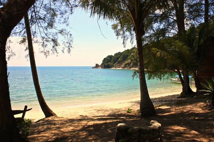
A scenic view from a shaded, tree-lined beach looking out over a turquoise bay towards a forested island headland in Malaysia.
A view of the sandy beach and clear coastal waters of Sibu Island.

Sibu Island history and protected-area timeline

Sibu Island's most significant historical development is its designation as a marine park in 1993. The declaration brought the island into Malaysia's marine protected area framework and emphasized the ecological value of its fringing reefs and surrounding waters. The small fishing village of Kampong Duku on the southern end of Sibu Besar reflects the longer human history of the island, where coastal communities have relied on the surrounding sea for livelihood. Over time, the island gradually shifted toward a dual identity, combining traditional settlement with beach-based recreation and reef-oriented watersports.

Sibu Island landscape and geographic character

The landscape of Sibu Island is shaped by a long, narrow island profile of roughly 6 km by 1 km. The interior is largely cloaked in tropical vegetation and sits atop pyroclastic rock with ashy characteristics, giving the island a geologically distinct foundation beneath its green cover. Four main beaches mark the eastern side of the island, where the most prominent coastal scenery is concentrated.

White sandy stretches and clear coastal water define the shoreline. Facing opposite directions are views toward Tinggi Island and the Johor mainland, with resort development concentrated on beaches with these orientations. Coral reef clusters close to the island complete the landscape picture, extending the island's natural scenery below the waterline and tying its physical setting to the surrounding South China Sea.

Sibu Island ecosystems, habitats, and plant life

Sibu Island's natural environment is defined by tropical island vegetation and a marine ecosystem built around fringing coral reefs. The island's land surface is dominated by tropical forest growth across pyroclastic terrain, while the surrounding waters contain the reef clusters that form the core of the island's marine ecological identity. The combination of forested island interior, sandy shoreline, and shallow reef environment creates a layered tropical ecosystem in a compact area.

The marine park designation recognizes these features as a coherent coastal and marine system rather than a single habitat type. The shallow reef areas near the beaches provide the ecological backbone for the island's snorkeling and diving activity, while the broader South China Sea setting places the island within a wider regional marine environment. The result is a tropical island ecosystem where land cover and reef habitat are tightly linked.

Sibu Island wildlife and species highlights

The wildlife profile of Sibu Island is closely tied to its marine and reef ecosystems. Coral reefs close to the island support the fish and invertebrate life that underpin its snorkeling and diving environment, while the surrounding open waters are also used by local fishing activity. Beyond the marine environment, the island's tropical vegetation provides habitat for typical coastal island wildlife, though the island's compact size means its terrestrial fauna is more limited than its marine biological diversity.

Sibu Island conservation status and protection priorities

Conservation on Sibu Island is anchored by its 1993 designation as a marine park under the Malaysian system of marine protected areas. This status frames the island as an area where coral reef ecosystems and the broader coastal marine environment around Johor are officially recognized for their ecological value. Marine park designation provides a regulatory and institutional framework for managing activity around the reefs and for distinguishing the island from unprotected coastal destinations.

The ecological importance of the island lies primarily in its shallow coral reef clusters, its clear waters, and its position within the South China Sea along the Johor coastline. These features together represent the type of tropical reef and coastal environment that marine park status is designed to safeguard. Beyond the formal designation, conservation relevance is reinforced by the relatively undisturbed character of much of the reef area close to shore.

Sibu Island cultural meaning and human context

Sibu Island carries a modest but genuine cultural dimension rooted in its coastal fishing community. At the southern end of Sibu Besar, the small village of Kampong Duku reflects a traditional pattern of island settlement tied to the surrounding sea. This community, comprising on the order of 40 families, represents the long-standing human presence on the island and provides cultural continuity alongside the more recent resort and recreation economy.

The Malay language, including the Johor-Riau Malay dialect, is the everyday language of the island, and the wider cultural setting is shaped by Johor's coastal traditions. The fishing village sits alongside beach resorts that face both neighboring islands and the mainland, giving the island a cultural profile that blends small-scale traditional sea-based livelihood with tourism-oriented development grounded in the same coastal waters.

Top sights and standout views in Sibu Island

Sibu Island is a designated marine park island in the South China Sea off Mersing District, Johor, recognized for its white sand beaches and coral reef clusters. Its protected status since 1993 sets it apart as an officially recognized reef and coastal environment along the eastern Johor coastline. The island carries a layered identity that combines tropical forest terrain built on pyroclastic rock, traditional fishing village life at Kampong Duku, and reef-based recreation along its eastern beaches.

Best time to visit Sibu Island

The character of a visit to Sibu Island is shaped by Malaysia's monsoon cycle, since most of the beach-facing resorts are closed during the annual three-month monsoon period. Visits to the reef and beach sides of the island are therefore typically most practical outside this monsoon window, when watersports operators and beach resorts are generally open. Conditions for snorkeling and diving tend to be more favorable when the surrounding waters are calmer and the reef area is fully accessible, though more precise monthly timing is not clearly established in the source material.
Monthly climate preview

Long term average temperature and precipitation rhythms across the protected area

Sibu Island Climate Normals and Monthly Weather Patterns

Representative coordinate records show sustained monthly temperatures between twenty six and thirty degrees Celsius alongside varying daily precipitation rates throughout the year. Examining the full twelve month profile reveals detailed temperature ranges and monthly precipitation distributions for Sibu Island.
Annual mean28 °C
27 °C29 °C
Jan27°
Feb27°
Mar27°
Apr28°
May29°
Jun28°
Jul28°
Aug28°
Sep28°
Oct28°
Nov27°
Dec27°
Warmest month
May

28.6 °C

Coolest month
January

26.6 °C

Wettest month
December

11.6 mm/day

Driest month
February

4 mm/day

Park location guide

Geography guide, regional context, and park location map for Sibu Island

Sibu Island park geography, regions, and map view in Malaysia

Understand where Sibu Island sits in Malaysia through a broader geographic reading of the surrounding landscape, nearby location context, and its mapped position within the national park landscape.

How Sibu Island fits into Malaysia

Malaysia is a federal constitutional monarchy located in Southeast Asia. The country consists of 13 states and three federal territories, divided by the South China Sea into Peninsular Malaysia on the Indochinese Peninsula and East Malaysia on the island of Borneo. With a population of over 34 million, it achieved independence from Britain in 1957 and became a modern federation in 1963. The country is recognized for its multicultural population, tropical climate, and significant economic role in the region.

Wider geography shaping Sibu Island in Malaysia

Malaysia occupies a strategic position in Southeast Asia, split by the South China Sea into two distinct regions. Peninsular Malaysia lies on the Indochinese Peninsula, sharing a land border with Thailand to the north and maritime borders with Singapore, Vietnam, and Indonesia. East Malaysia occupies the northern portion of Borneo, sharing land borders with Brunei and Indonesia, and maritime borders with the Philippines and Vietnam. The country's terrain includes coastal plains, mountain ranges such as the Titiwangsa in the peninsula, and extensive tropical rainforests.

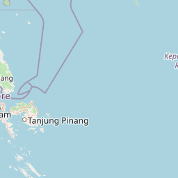
Map view of Sibu Island

Use this park location map to pinpoint Sibu Island in Malaysia, understand its exact geographic position, and read its mapped placement within the surrounding landscape more clearly.

Pigeon | © OpenStreetMap contributors

Location context for Sibu Island

Johor

Explore protected coastal landscapes, tropical vegetation, and coral reef ecosystems through detailed park photography.

Sibu Island Photos and Landscape Scenery: Visualizing Protected Marine Terrain

Visual documentation captures the unique topography, sandy shorelines, and marine ecosystems that define the protected environment of Sibu Island. Examining these field photographs reveals the distinct geological character, coastal vegetation, and reef formations shaping the surrounding South China Sea habitat.

A scenic view from a shaded, tree-lined beach looking out over a turquoise bay towards a forested island headland in Malaysia.

A scuba diver swims through clear blue water past a large cluster of pink and white soft corals.

Park atlas

Compare adjacent coastal terrain, coral reefs, and regional island geography.

Exploring Parks Near Sibu Island and Surrounding Marine Protected Areas

Browsing other protected areas near Sibu Island reveals connected coastal habitats and marine environments along the Johor coastline. Evaluating these adjacent locations provides broader regional context for tropical island ecosystems and regional park geography.
Protected areaJohor
About 12 km away#1 closest

North

Tinggi Island Protected Area: Geography, Rainforest Terrain, and Johor Coastal Map

Mountainous forest meets extensive coral-rich coastal waters.

Located southeast of Mersing, Tinggi Island is defined by its dramatic silhouette and dense rainforest interior. The protected landscape stretches from the elevated peak of Mount Semundu down to a shoreline of white sand and coastal caves, creating a distinct marine and terrestrial environment unique to the Johor region.

Water
Major water bodies
Season
Year-round
A minimalist watercolor illustration depicting a tropical island coastline with sand beaches, green trees, and rolling hills in the background.
Marine protected areaJohor
About 29 km away#2 closest

Northwest

Besar Island Marine Protected Area: Coastal Geography and Protected Waters in Johor

Mapping the island's reef ecosystems and tropical landscape

Besar Island offers a distinct look at a small-scale marine protected area off the Johor coast. Its geography encompasses a transition from sandy beach fronts to a hilly, jungle-clad interior, all contained within a gazetted two-nautical-mile conservation zone. The surrounding waters support approximately 60 marine species, making this an essential case study for understanding protected marine habitats within the Babi Islands archipelago.

Area
4.77 km²
Relief
Upland
Climate
Tropical
Access
Easy access
A watercolor painting showing layers of soft green and pink rolling hills, with a line of trees in the midground and an open, flat foreground.
Protected areaJohor
About 37 km away#3 closest

North

Rawa Island Protected Area: Coastal Geography and Island Landscape Context in Johor

A protected coral island within the Johor archipelago

Rawa Island serves as a significant protected landscape off the coast of Johor, Malaysia. Defined by its sharp contrast between rocky cliffs and clear, coral-filled waters, the island represents a crucial node in regional island geography. Delve into the spatial characteristics and environmental features of this South China Sea destination through our map-driven atlas framework.

Area
0.23 km²
Water
Water-dominated
Protected areaJohor
About 50 km away#4 closest

Northeast

Pemanggil Island Protected Landscape: Johor Offshore Geography and Island Topography

Mapping coastal features and inland terrain in the South China Sea.

Pemanggil Island serves as a significant geographic landmark within the Mersing cluster of Johor. This detailed atlas entry focuses on the island's structural composition, including its prominent central hill, the rocky interior, and coastal features such as Teluk Lancang. Understand the maritime geography and spatial character of this protected area within the context of the southern Malay Peninsula.

Area
8.82 km²
Relief
Upland
Climate
Tropical
Access
Moderate access
Watercolor illustration of a horizontal landscape featuring a winding river, green forests, and soft, pastel colored mountain ridges against a white background.
Marine protected areaJohor
About 56 km away#5 closest

Northeast

Aur Island Marine Protected Area: Johor Regional Coastal and Island Geography

Rugged island terrain and sheltered coral ecosystems.

Aur Island serves as a significant marine protected area within the Johor Marine Park archipelago. Located in the South China Sea, the island is characterized by its hilly interior, white-sand shorelines, and diverse offshore coral reef systems. Its geographic proximity to neighbouring Dayang Island creates a paired landscape that highlights the environmental importance of these remote Malaysian waters.

Area
14.5 km²
Relief
Lowland
Climate
Tropical
Access
Moderate access
A minimalist watercolor illustration depicting abstract green rolling hills and distant pink-toned ridges against a white background.
Wildlife reservePahang
About 69 km away#6 closest

North

Pulau Tioman Wildlife Reserve: Mapping Island Rainforests and Marine Boundaries

Protected island geography within the Pahang region

Covering the forested interior of Tioman Island, this wildlife reserve protects lowland and hill rainforest habitats that rise to Gunung Kajang. The area serves as a significant conservation landscape, bridging remote inland mountain terrain with vibrant coral-fringed coastlines in the South China Sea.

Area
136 km²
Established
1972
Relief
Mountain
Climate
Tropical
National parkJohor
About 81 km away#7 closest

West

Endau-Rompin National Park: Ancient Tropical Rainforest Protected Landscape in Johor, Malaysia

Explore unique mapped geography and ancient geological features.

Endau-Rompin National Park in Johor, Malaysia, is a testament to Earth's ancient history, housing tropical rainforests built upon geological formations around 248 million years old. This protected area offers a detailed look at rugged mountainous terrain, vital river systems, and a diverse mapped landscape, crucial for understanding regional geography and conservation. Its status as one of the oldest rainforest complexes makes it a significant site for exploring the planet's prehistoric natural heritage and protected land distribution.

Area
870 km²
Established
1993
IUCN
II
Relief
Mountain
Nature reserveJohor
About 113 km away#8 closest

Southwest

Pulai River Nature Reserve: Johor Coastal Mangrove and Estuarine Geography

Protected Ramsar wetland and coastal landscape in southern Malaysia.

Spanning from the highlands of Mount Pulai to the Tebrau Straits, Pulai River Nature Reserve acts as a major ecological interface in Johor. This site encompasses dense mangrove forest reserves and the country's single largest seagrass bed, serving as a primary study area for regional coastal conservation and wetland management.

Established
2003
Relief
Lowland
Scope
Mixed
Water
Water-dominated

Common questions about visiting, size, designation, and location context for Sibu Island

Sibu Island FAQs for park facts, access, geography, and protected area context

Find quick answers about Sibu Island, including protected-area facts, park geography, trail and visitor context, and how the park fits into its surrounding country and regional landscape.
MoriAtlas Explorer

Continue Your Protected Areas Search Across the Global Atlas

Deepen your exploration by continuing the structured search for national parks and protected areas worldwide. Utilize the comprehensive filtering capabilities to compare different conservation landscapes and refine your understanding of global park geography. Discover more about the distribution and characteristics of protected natural areas.

Global natural geography