
Lakes
Park geography
Analyzing the terrain, regional landscape context, and recorded natural features
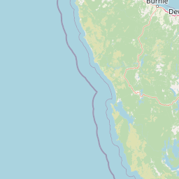
Comprehensive Geographic Profile and Mapped Boundaries of Southwest National Park, Tasmania
Discover the geographic expanse of Southwest National Park in Tasmania, covering 6182.67 square kilometers of complex mountainous terrain. This structured profile examines internal natural features including the Western Arthur Range and Port Davey, while highlighting the diverse forest and wetland environments within its borders.
Related tags
wildernessnational parkTasmaniaWorld Heritage Area temperate rainforest
Tasmania's vast wilderness frontier of ancient landscapes and critically endangered species
Southwest National Park
Southwest National Park is Australia's largest national park in Tasmania, covering approximately 6,183 square kilometers of pristine wilderness in the island's remote southwest. The park forms the core of the Tasmanian Wilderness World Heritage Area, a landscape of extraordinary ecological and geological significance that has remained largely untouched by permanent human settlement. Characterized by dramatic buttongrass moorlands, rugged mountain peaks, ancient rainforests, and remote coastal fjords, the park represents one of the last great temperate wilderness areas in the Southern Hemisphere. The region experiences a notoriously harsh climate with extremely high rainfall, fierce winds, and persistent cloud cover, which has historically deterred human habitation and preserved its natural state. Despite the challenging environment, the park supports remarkable biodiversity with numerous species found nowhere else on Earth, including the critically endangered orange-bellied parrot whose only significant breeding grounds lie within the park's boundaries.
- Location
- Australia
- Park type
- National park
- Established
- 1968
- Area
- 6,182.7 km²
Location overview
Administrative boundaries and regional status within Tasmania, Australia
Southwest National Park Geographic and Regional Positioning
Southwest National Park is positioned entirely within the region of Tasmania in Australia. Regional data profiles define its administrative boundaries as a single-country, non-transboundary reserve.
- Countries
- Australia
- Regions
- Tasmania
- Primary location
- Tasmania
- Geographic setting
- Inland
Boundary and coordinates
Southwest National Park’s mapped extent spans 6,182.67 km²
Southwest National Park mapped boundary and 6,182.67 km² area
Southwest National Park has stored boundary geometry that maps the breadth of its 6,182.67 km² protected footprint. The available size is a single overall value, with no land-versus-marine allocation and no measured perimeter.
- Boundary area
- 6,417.6 km²
- Boundary perimeter
- 1,456.4 km
- Northernmost point
- 42.69° S
- Southernmost point
- 43.8612° S
- Easternmost point
- 147.0249° E
- Westernmost point
- 145.6054° E
- Geographic centre
- 43.1653° S, 146.2769° E
- North–south span
- 130.1 km
- East–west span
- 115.2 km
Terrain and natural features
Stored mountain classifications and recorded geographic features
Southwest National Park Terrain and Named Natural Features Atlas
Protected mountain relief classifications define the primary terrain framework across Southwest National Park. Linked feature cards supply names, types, measurements, and spatial relationships for recorded locations.
Selected named natural features
Capes
Svenor Point
Capes
Doom Head
Bays
Coffin Bay
Peaks
McPartlans Bluff
1,100 m
Peaks
Madonna Ridge
920 m
Environmental setting
Temperate climate zones, mountain relief, and diverse habitat types
Southwest National Park Environmental Classifications and Physical Settings
Recorded landscape features, temperate climate zones, and forest cover form complementary ways to read the physical setting of Southwest National Park. Connected atlas classifications link stored environmental categories to relevant regional destinations.
- Relief
- Mountain
- Climate
- Temperate
- Water
- Major water bodies
- Forest cover
- Partial forest
- Seasonality
- Seasonal
Landscape features
Mountains · Valleys · Wetland · Forest · Rivers · Lakes · Coast
Habitat types
Temperate broadleaf forest · Wetland · Riverine habitat · Grassland
MoriAtlas Explorer
Continue Exploring Southwest National Park's Mapped Wilderness and Regional Geography
Delve deeper into the structured geographic context of Southwest National Park. Understand its extensive mapped boundaries, unique buttongrass moorland terrain, and its critical role as a protected landscape within Tasmania's remote wilderness. This exploration helps build a comprehensive atlas view of Australia's significant natural areas.
Browse next
Global natural geography
Explore related park routes
Explore MoriAtlas Global ParksBrowse All MoriAtlas ParksGlobal Park Map DiscoveryMoriAtlas: Browse All CountriesBrowse All MoriAtlas ContinentsNational Park Environment AtlasGrand Canyon National Park AtlasYellowstone National Park AtlasYosemite National Park Atlas and GeographySerengeti National Park AtlasGalápagos National Park Protected LandscapeBanff National Park Geography and AtlasKruger National Park Atlas EntryUluṟu-Kata Tjuṯa National Park AtlasExplore Uluru-Kata Tjuta National Park GeographyPlitvice Lakes National Park AtlasFiordland National Park Protected LandscapeGreat Smoky Mountains National Park AtlasAfghanistan National Parks and Protected AreasAlbania National Parks and Protected AreasAlgeria National Parks and Protected AreasAmerican Samoa National Parks and Protected AreasAndorra National Parks and Protected AreasAngola National Parks and Protected AreasAntarctica National Parks and Protected AreasAntigua and Barbuda Park List