Mori Atlas logo
Protected areaSpeyerer Wald

Tracing the geological origins of inland dunes, sandy soils, and rare woodland habitats in Germany.

Speyerer Wald: An Extensive Protected Lowland Forest and Alluvial Fan Landscape in Rhineland-Palatinate

(Speyerer Wald und Haßlocher Wald und Schifferstädter Wiesen)

Speyerer Wald stands as the largest continuous woodland on the alluvial fan of the Speyerbach and Rehbach streams within the Rhine Plain. This protected area preserves a striking geological record where ice age processes shaped sandy, well drained soils that favored forest survival over agricultural development. Today, the landscape features a complex mosaic of commercial pine and oak stands, expansive inland sand dunes, and vital wet meadow habitats that support a specialized bird community.

lowland forestalluvial faninland sand dunessand grasslandbeech-oak forestpine forest

Speyerer Wald

Protected area

Park overview

Structured park overview, official facts, and landscape profile for Speyerer Wald

Speyerer Wald park facts, protected area profile, and essential visitor context

Review the core facts for Speyerer Wald, including designation, size, terrain, visitor scale, habitats, and operating context in one park-focused overview.

About Speyerer Wald

Speyerer Wald is the name given to the large, almost continuous block of woodland that fills the eastern lobe of the Upper Rhine Plain between the Palatinate wine country and the city of Speyer. It is not a national park in the strict sense, but rather a working forest landscape that has accumulated a stack of nature protection designations and still functions as the most important green space in the Vorderpfalz.

The defining feature of the Speyerer Wald is its geology. The forest grows on a large sand and gravel fan laid down at the end of the last ice age by meltwater streams that flowed east out of the Palatinate hills. Because the upper Rhine once shifted its bed across this part of the plain, the rivers coming off the hills repeatedly built up fresh deposits. When farming became the dominant land use on the richer loess soils around them, the poorer sandy fan surfaces were simply left as woodland, which is why such a large forest survived so close to dense settlement in the Rhine Plain.

In modern land management terms, the Speyerer Wald is divided into several named woodland blocks running from west to east. The Ordenswald, a former estate of the Teutonic Order, marks the western tip of the forest near Neustadt. Moving east, the forest widens into areas known as the Unterwald, Mittenwald, Oberwald, Haßlocher Wald, and Ganerbwald, and then, around Speyer, into the Schifferstadter Wald, the Speyerer Stadtwald, and the Dudenhofener Wald. Highways and main roads divide the forest rather than cross it as open corridors, so the eastern edge is now shaped by the Bundesstraße 9 and other major routes.

The forest has been shaped by human use for centuries. In the Middle Ages, the Speyerer Landwehr, a defensive earthwork of the free imperial city of Speyer, ran along the woodland edge to protect the fields and grazing animals from raiders. In more recent times, urban expansion of Speyer after the First World War steadily reduced the eastern margin of the forest, while the A 61 motorway slices through the northern third and the A 65 cuts through near Neustadt. The railway from Schifferstadt to Wörth has crossed the forest since 1847. Despite these pressures, the Speyerer Wald remains a coherent forested landscape on a scale that is unusual in a plain dominated by farmland, roads, and towns.

Its value for nature conservation is now formally recognized at the European level. The Speyerer Wald and its associated meadows form both a Fauna-Flora-Habitat site and a Bird Protection Area under the EU Natura 2000 network. A separate landscape protection area, Rehbach-Speyerbach, covers a broader buffer around the forest. These overlapping designations place the Speyerer Wald among the most important lowland forest conservation areas along the German stretch of the Rhine and connect it to a wider palette of protected sites in the southern Rhine Plain, including the Bellheimer Wald and the larger Bienwald further south.

Quick facts and research context for Speyerer Wald

Speyerer Wald is a large lowland forest complex in the Vorderpfalz, the eastern part of the Palatinate region in Rhineland-Palatinate, Germany. It stretches for nearly 18 kilometers from the foot of the Haardt hills near Neustadt an der Weinstraße eastward to the outskirts of Speyer on the Rhine.

The whole forest sits on the Pleistocene alluvial fan of the Speyerbach and Rehbach, with the smaller fans of the Kropsbach and Modenbach to the south. The sandy soils supported woodland instead of arable land, so large forest blocks have survived. The area carries overlapping designations, including the landscape protection area Rehbach-Speyerbach, the FFH site Speyerer Wald und Haßlocher Wald und Schifferstädter Wiesen, and the bird protection area Speyerer Wald, Nonnenwald und Bachauen zwischen Geinsheim und Hanhofen. The local climate is mild and relatively dry, with annual mean temperatures around 10 degrees Celsius and precipitation near 600 millimeters, similar to nearby wine growing areas.

Protection and recognition

Documented terrestrial protection metrics and Natura 2000 records for Speyerer Wald.

Speyerer Wald Protection Status and International Recognition Data

Speyerer Wald maintains documented terrestrial protection status supported by official Natura 2000 recognition records. Structured conservation metrics detail the management scope and designation framework associated with the protected area.

International recognition

Protection details

Protection scope
Terrestrial
Transboundary protection
No
WDPA ID
555521623
Park context

Deeper park guide and search-rich context for Speyerer Wald

Speyerer Wald history, landscape, wildlife, and travel context

Explore Speyerer Wald through its history, landscape character, ecosystems, wildlife, conservation priorities, cultural context, and seasonal travel timing in a structured park guide built for atlas discovery and search intent.

Why Speyerer Wald stands out

Speyerer Wald is best known for being the largest surviving lowland forest on the eastern Rhine Plain alluvial fans, and for the unusual combination of inland sand dunes, dry sand grassland, and old oak woodland that this setting supports. The dunes near Speyer and Dudenhofen, including the prominent Ameisenberg, are among the most distinctive landscape features of the entire Upper Rhine Graben. The forest is also recognized as an important refuge for bird species that depend on open, sunny woodland and small stream valleys, including nightjar, wryneck, grey-headed woodpecker, middle spotted woodpecker, and the corncrake. These species, together with rare sand grassland insects such as the green grasshopper Aiolopus thalassinus, give the Speyerer Wald a conservation value that goes well beyond its size as a local recreation forest.
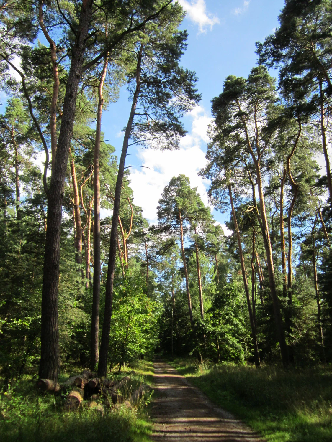
A dirt path leading into a dense forest of tall, mature Scots pine trees under a partially cloudy blue sky.
Tall Scots pine trees lining a dirt trail in the Speyerer Wald.

Speyerer Wald history and protected-area timeline

The Speyerer Wald has been used and protected in changing ways over many centuries. During the Middle Ages, when the free imperial city of Speyer was at the western edge of its fields, the so called Speyerer Landwehr ran along the forest margin. This earthwork protected crops and grazing animals against raiders and other outside threats, and in doing so it marked the political as well as the ecological boundary of the forest.

The western tip of the woodland, the Ordenswald, has its own particular origin. For long stretches of the medieval period it belonged to the Teutonic Order, and the name Ordenswald still recalls this institutional history. To the east, the forest eventually came under the administration of the city of Speyer and surrounding municipalities, which today treat it partly as a municipal Stadtwald, a forest held in trust for the community rather than for commercial timber alone.

A second important chapter in the area's history began with the arrival of the railway between Schifferstadt and Wörth in 1847, which cut through the forest as a long straight line. This was followed in the twentieth century by the construction of the A 65 motorway near Neustadt and the A 61 through the northern part of the forest, and by gradual urban expansion from Speyer that has eaten into the eastern margin, most notably around the Speyer-Nord and Speyer-West districts and a new commercial zone between them. In 1981, on 30 November, the area received its first comprehensive protection status as the landscape protection area Rehbach-Speyerbach, which was amended in 1987.

A more recent milestone came in 1998, when large parts of the Speyerer Wald were formally designated under the European Union Habitats Directive as the FFH area Speyerer Wald und Haßlocher Wald und Schifferstädter Wiesen. A separate bird protection area, Speyerer Wald, Nonnenwald und Bachauen zwischen Geinsheim und Hanhofen, followed under the Birds Directive. Together with local planning measures for noise protection and recreation, these steps have defined the modern management regime of the forest and fixed its identity as one of the most important conservation forests in the eastern Rhine Plain.

Speyerer Wald landscape and geographic character

Speyerer Wald is, at heart, a forest built by ice age water. Streams that today are modest, including the Speyerbach, Rehbach, Kropsbach, and Modenbach, once carried massive loads of sand and gravel out of the Palatinate hills. Where these streams broke out of the narrow valleys near Neustadt and spread into the open Rhine Plain, they built a classic triangular alluvial fan. Over time the same process repeated itself slightly to the south, producing a series of fans that line up along the eastern foot of the Palatinate Forest, with the Speyerer Wald as the largest and the Bienwald further south as another major example.

The surface of the Speyerer Wald fan is sandy and gently sloping, and rises only slightly above the true Rhine floodplain. Toward the eastern end, the finest sands were deposited, and in dry periods these were blown inland to form a belt of dunes. Several of these inland dunes have survived, including the Ameisenberg in the Speyerer Stadtwald, described as the highest of them. Some of these dunes were kept free of forest cover in the twentieth century through the use of the area as a military training ground, which paradoxically allowed a rare dry grassland habitat to develop on top of the sand.

The forest itself is largely a pine and oak woodland on poor, well drained soils, with pockets of near natural beech-oak forest where conditions allow. Where the alluvial fans fade into the flat floodplain of the Rhine, the landscape opens into small meadows and wet grassland along the slow Speyerbach and Rehbach streams. The central spine of the forest is therefore a roughly triangular block, narrow at Neustadt and widening to about four to five kilometers north to south as it approaches Speyer.

Speyerer Wald ecosystems, habitats, and plant life

The natural character of the Speyerer Wald is shaped by two very different habitat types that meet here in unusually close proximity. On the dry, sandy core of the alluvial fan grows a pine dominated forest that includes stands of older oak and, in more sheltered places, near natural beech-oak woodland. The species mix found here is more typical of eastern German lowland forests than of the surrounding Palatinate wine country.

Around the edges of the forest and along the slow lowland streams, the picture changes. The Rehbach and Speyerbach valleys hold nutrient-poor wet meadows, known in German as Stromtalwiesen, that are flooded in spring and dry out in summer. These open habitats are a crucial counterweight to the dense forest and are part of what makes the Speyerer Wald ecologically distinctive. In the south, the Kropsbach and Modenbach floodplains add further small scale habitat variety.

Perhaps the most unexpected natural element is the chain of inland sand dunes along the eastern margin of the forest near Speyer and Dudenhofen. Where the woodland cover was removed, particularly around former military areas, these dunes, together with associated sand grassland and sand heath patches, became a refuge for species that have otherwise almost disappeared from the Rhine Plain. The combination of dry dunes, acid sand grassland, wet meadows, and deciduous woodland in a single protected complex is rare in this part of Germany and gives the Speyerer Wald an ecological identity that is out of proportion to its area.

Speyerer Wald wildlife and species highlights

Speyerer Wald is particularly valued for its bird life, which has shaped its formal protection status. The bird protection area covering the forest and adjacent stream valleys lists old oak stands on lowland sites and dry pine-oak woodland on the dunes as the two main bird habitats. In the older oaks, grey-headed woodpecker and middle spotted woodpecker are the dominant species, while the open, sunny dune woodland supports large numbers of nightjars and wrynecks.

Along the wet meadows and small streams of the Speyerbach, Rehbach, Kropsbach, and Modenbach, ground-nesting meadow birds find breeding habitat that has largely vanished elsewhere in the intensively farmed Rhine Plain. The corncrake is specifically named as a flagship or Leitart of the area, a species whose presence signals the survival of tall, unmown meadow and rough vegetation along the streams.

The fauna of the sand dunes themselves is unusually rich for an inland setting. Studies of the dunes between Speyer and Dudenhofen, particularly those kept open by former military use, have found a community of sand-loving insects that includes very rare species such as the green grasshopper Aiolopus thalassinus. Together with other rare sand grassland specialists, these insects have turned a small set of dunes into one of the most important inland sand habitats in Rhineland-Palatinate.

Speyerer Wald conservation status and protection priorities

Speyerer Wald is one of the most comprehensively protected forest landscapes in the German part of the Upper Rhine Plain. Three overlapping designations cover essentially the same area at different scales. The landscape protection area Rehbach-Speyerbach, established on 30 November 1981 and amended in 1987, provides broad protection for the wider forest and stream landscape. In 1998, a large part of the area was formally designated as the FFH site Speyerer Wald und Haßlocher Wald und Schifferstädter Wiesen under the European Union Habitats Directive, and the adjacent bird protection area Speyerer Wald, Nonnenwald und Bachauen zwischen Geinsheim und Hanhofen followed under the Birds Directive. Internationally, the area is recorded in the World Database on Protected Areas under WDPA ID 555521623, and is classified at IUCN Category IV, Habitat or Species Management Area.

The conservation value of the area is not limited to the forest itself. The official Natura 2000 description highlights three elements: extensive woodland with species of light woodland such as the nightjar, a unique sand grassland community hosting very rare species, and nutrient poor wet meadows along near natural lowland streams. Together these elements justify protecting a forest that might otherwise be valued mainly for timber and recreation.

Management of the Speyerer Wald reflects this dual role. On one hand, ongoing forestry planning documents, including the Forsteinrichtungswerk for the Speyer forest office covering the Stadtwald Speyer and the Bürgerhospitalwald, guide commercial forest use on a ten year cycle. On the other hand, the Speyer municipal land use plan explicitly calls for the development of a dense understory in forest strips along the A 61, B 9, L 528, L 454, and the railway line in order to maximize noise protection for nearby residential and recreation areas, which is an unusual example of a conservation plan written into urban planning policy.

Speyerer Wald cultural meaning and human context

The Speyerer Wald has a long history of being a shared landscape rather than a purely private one. The Ordenswald in the western part of the forest takes its name from the Teutonic Order, which held large blocks of woodland in this region during the Middle Ages and after. Further east, the division of forest rights between Speyer and neighboring communities has produced a mosaic of named woodland blocks, including the Ganerbwald, a traditional term for a forest held jointly by several owners or families, and the Schifferstadter Wald and Dudenhofener Wald, named for surrounding towns. The very name Stadtwald Speyer signals the urban roots of much of the forest's modern ownership and use.

The forest has also shaped how the city of Speyer grew. The medieval Speyerer Landwehr followed the woodland edge to defend the city fields, and today the eastern margin of the Speyerer Wald still sets a fairly clear limit to how far Speyer can extend. Municipal planning documents repeatedly emphasize the forest as a recreation resource, and local nature education work at facilities such as the Treffpunkt Wald of the Speyer Environmental Office links the city's identity directly to its surrounding forest.

In modern Rhineland-Palatinate planning, the Speyerer Wald is treated as a key piece of regional green infrastructure rather than simply as a local wood. The state's recreational plans for the Stadtwald Speyer, and Natura 2000 management for the broader protected area, both reflect the expectation that the forest will continue to serve a densely populated region stretching from Neustadt through Haßloch, Schifferstadt, and Speyer to the Rhine itself.

Top sights and standout views in Speyerer Wald

A near continuous lowland forest of around 18 kilometers, large enough to act as a regional recreation and climate resource in the middle of the Rhine Plain. An ice age alluvial fan landscape, where the form of the forest and the survival of woodland are directly explained by sandy, infertile soils that were never cleared for agriculture.

Inland sand dunes and sand grassland along the eastern margin, including the prominent Ameisenberg, which support rare insects such as the green grasshopper Aiolopus thalassinus. A rich bird community of light, sunny woodland and wet meadow specialists, including nightjar, wryneck, grey-headed woodpecker, middle spotted woodpecker, and corncrake. Triple layered protection as a landscape protection area, an EU Habitats Directive site, and an EU Birds Directive site, with the site recorded under WDPA ID 555521623.

Best time to visit Speyerer Wald

Speyerer Wald can be visited at any time of year, but the experience changes meaningfully with the seasons. Spring is the most rewarding period for birds and meadow species, when the wet meadows along the Speyerbach and Rehbach flood with meltwater and ground-nesting birds such as corncrake settle into the tall vegetation. In late spring and early summer the dune areas near Speyer and Dudenhofen warm up enough to support their rare sand grassland insects, which are easiest to observe in calm, sunny weather.

Summer is the main recreation season for local residents, since the climate of the Rhine Plain is mild, with annual mean temperatures near 10 degrees Celsius and precipitation of about 600 millimeters. Shaded pine stands offer relief from summer heat, though visitors should expect busy paths near Speyer, Dudenhofen, and Haßloch on weekends. Autumn brings the most atmospheric forest experience, with changing colors in oak and beech patches and quiet, low light through the pine canopy. Winter is generally mild but can be foggy in the Rhine Plain, and visits focus on the dune landscape and broad forest rides rather than on the wet meadows, which are at their least active.

Monthly climate preview

Review long-term representative monthly temperature ranges and precipitation averages across the protected area.

Speyerer Wald Climate Normals, Annual Temperature and Precipitation Profiles

Representative coordinates document measured long-term temperature swings and monthly precipitation patterns across Speyerer Wald from 1991 to 2020. Opening the complete climate profile reveals full twelve-month averages for maximum and minimum temperatures.
Annual mean10 °C
0 °C20 °C
Jan
Feb
Mar
Apr
May14°
Jun18°
Jul20°
Aug20°
Sep15°
Oct10°
Nov
Dec
Warmest month
July

20.4 °C

Coolest month
January

0.3 °C

Wettest month
July

2.2 mm/day

Driest month
April

1.4 mm/day

Park location guide

Geography guide, regional context, and park location map for Speyerer Wald

Speyerer Wald park geography, regions, and map view in Germany

Understand where Speyerer Wald sits in Germany through a broader geographic reading of the surrounding landscape, nearby location context, and its mapped position within the national park landscape.

How Speyerer Wald fits into Germany

Germany is a federal republic in Western and Central Europe with a population of over 83 million across sixteen constituent states. It is Europe's largest economy by nominal GDP and a major global exporter and importer. The capital is Berlin, and the country borders Denmark, Poland, Czech Republic, Austria, Switzerland, France, Luxembourg, Belgium, and the Netherlands.

Wider geography shaping Speyerer Wald in Germany

Germany is located in Western and Central Europe, spanning 357,022 km². It borders Denmark to the north, Poland and the Czech Republic to the east, Austria and Switzerland to the south, and France, Luxembourg, Belgium, and the Netherlands to the west. The country has coastlines on the Baltic Sea and North Sea to the north, with the Alps located in the southern region.

Map view of Speyerer Wald

Use this park location map to pinpoint Speyerer Wald in Germany, understand its exact geographic position, and read its mapped placement within the surrounding landscape more clearly.

Pigeon | © OpenStreetMap contributors

Location context for Speyerer Wald

Rhineland-Palatinate
Recorded earthquake history

Explore the Historical Record of Earthquakes Near Speyerer Wald

Review documented seismic events that have occurred in the vicinity of Speyerer Wald. This MoriAtlas catalogue provides a structured way to inspect historical earthquake data, including event magnitude and proximity, for those investigating the seismic history of this distinctive woodland area.

Speyerer Wald Earthquake History

Catalogued events

15 events

Strongest magnitude

Magnitude 3.4

Most recent event

Feb 16, 2008

This history includes earthquakes recorded inside the park or within 50 km of its borders

Visual reference of alluvial forests, inland sand dunes, and protected habitats

Speyerer Wald Photos and Landscape Scenery Exploration

Visual documentation of Speyerer Wald reveals the complex terrain of the Upper Rhine Plain alluvial fan and its rare inland sand dunes. Examining these protected habitats provides a deeper understanding of the forest structure, sandy grasslands, and specialized ecosystems.

A dirt path leading into a dense forest of tall, mature Scots pine trees under a partially cloudy blue sky.

Panoramic view of a sandy dune landscape bordered by a green forest under a clear blue sky.

Park atlas

Compare adjacent alluvial forests, inland sand dunes, and regional nature reserves

Explore Other Parks Near Speyerer Wald and Surrounding Protected Landscapes

Continue exploring protected natural areas near Speyerer Wald to compare related lowland woodlands, sandy soils, and regional river valley ecosystems across the Upper Rhine Plain. Examining adjacent conservation zones provides deeper geographic context into the ice age landforms and protected habitats shaping this wider region.
Nature reserveRheinland-Pfalz
Mapped location lies within the park boundary#1 closest

Southwest

Lochbusch-Königswiesen Nature Reserve: Protected Wetland and River Floodplain Geography

A detailed look at regional floodplain mapping in Rheinland-Pfalz

Lochbusch-Königswiesen stands as a critical protected landscape within the Rhine lowlands of Rheinland-Pfalz. Centered on the Speyerbach river corridor, this nature reserve maintains rare lowland bog and wet meadow communities. Its structured boundaries demonstrate the persistence of floodplain geography in an intensively managed region, offering a distinct focus for those examining protected-area distribution in Germany.

Area
1.99 km²
Established
1983
A soft watercolor illustration of a wetland scene with a small pool of water in the foreground, a line of deciduous trees in the midground, and rolling hills in the background.
Nature reserveRheinland-Pfalz
About 5.1 km away#2 closest

Northeast

Neuhofener Woog Nature Reserve: Exploring Rhine Floodplain Geography in Rheinland-Pfalz

Mapping protected swamp forests and ancient river meander ecosystems

Neuhofener Woog serves as a vital protected area in the Rhein-Pfalz-Kreis district. This former Rhine meander preserves a natural transition between water-dominated basins, ash-alder swamp woodlands, and reed beds. It stands as a defined natural landscape within the heavily modified Upper Rhine Plain, offering a clear view of floodplain hydrological patterns.

Area
1 km²
Established
1999
Watercolor painting showing a calm river shoreline with soft green trees and light pinkish ground accents.
Protected areaRhineland-Palatinate
About 5.4 km away#3 closest

East

Angelhofer Altrhein: Protected Riparian Environment in Rhineland-Palatinate

Historic river oxbow, floodplain forests, and Natura 2000 habitats

Located in the heart of the Upper Rhine plain, the Angelhofer Altrhein constitutes an essential protected area known for its distinct floodplain meadow and forest ecosystems. This backwater environment, once a main channel of the Rhine, provides critical habitat for diverse species and serves as a natural contrast to the surrounding industrial and recreational landscapes of the region.

Relief
Lowland
Climate
Temperate
Access
Easy access
Scope
Terrestrial
Nature reserveRheinland-Pfalz
About 5.6 km away#4 closest

Southeast

Flotzgrün Nature Reserve: Protected Floodplain Landscapes and Rhine Geography in Rheinland-Pfalz

Mapping historical island creation and modern conservation polders

Flotzgrün serves as a compelling geographic entity within the Upper Rhine, functioning as both an active flood management polder and a protected riparian environment. This site offers insights into the intersection of 19th-century river straightening and modern ecological restoration, revealing a landscape defined by controlled wetlands, old river arms, and managed floodplain habitats.

Area
3.4 km²
Relief
Lowland
Scope
Terrestrial
Water
Major water bodies
A horizontal watercolor illustration depicting a calm lake with grassy foreground reeds and distant soft purple hills under a clear sky.
Nature reserveRhineland-Palatinate
About 6 km away#5 closest

Northwest

Mußbacher Baggerweiher Nature Reserve in the Rhineland-Palatinate Protected Landscape Atlas

Wetland habitat mosaic and post-industrial geography

Mußbacher Baggerweiher stands as a textbook example of industrial recovery, where a former extraction site for motorway construction transformed into a thriving protected wetland. Situated in the eastern reaches of Neustadt an der Weinstraße, the reserve offers a dense mosaic of shoreline habitats, sheltered water, and small islands that contribute significantly to regional conservation in the Upper Rhine Plain.

Area
0.205 km²
Established
1989
A pale, minimalist watercolor painting showing a wide river flowing through a lush green floodplain with rolling hills in the background.
Nature reserveRhineland-Palatinate
About 6.6 km away#6 closest

Southeast

Speyerer Auwald Nature Reserve: Protected Alluvial Forest Geography in Rhineland-Palatinate

An essential Rhine valley floodplain and habitat mosaic

Located along the Upper Rhine, the Speyerer Auwald encompasses a vital protected landscape of alluvial forests, relic oxbows, and traditional meadows. This record traces the park boundaries, hydrological features, and the distinct ecological zones that make this floodplain forest a cornerstone of the regional geography in Rhineland-Palatinate.

Relief
Lowland
Climate
Temperate
Access
Easy access
Scope
Terrestrial
A pale, atmospheric watercolor painting showing a quiet river scene with green trees and a hanging branch in the foreground, rendered in a light and airy style.
Nature reserveRhineland-Palatinate
About 7.6 km away#7 closest

Southeast

Schwarzwald Nature Reserve: A Protected Rhine Floodplain Landscape in Rhineland-Palatinate

Geographic atlas of alluvial forests and oxbow river dynamics

Schwarzwald represents a significant nature reserve in Germany, characterized by its position between the modern Rhine and the Lingenfelder Altrhein. The area contains a rich collection of floodplain features, including alluvial forests, pollarded willows, and standing gravel pit lakes, offering a comprehensive look at the riparian geography of the Upper Rhine.

Area
3.41 km²
Established
1997
A soft, light watercolor painting of a rolling rural landscape featuring rows of vineyards in the foreground and tree-covered hills in the distance.
Nature reserveRheinland-Pfalz
8.9 km away#8 closest

Northwest

Haardtrand Nature Reserve: Geographic Overview and Protected Landscape Mapping

Bird protection area within the Rheinland-Pfalz region.

Spanning roughly 14,700 hectares, Haardtrand serves as a critical link between the Palatinate Forest and the Rhine valley. This nature reserve is composed of a distinctive mosaic of habitat types, including mature broadleaf woodlands, traditional orchard meadows, and sandy terraces, which together create a highly structured environment for diverse raptors and forest-dwelling bird species.

Area
147.28 km²
Established
2004

Common questions about visiting, size, designation, and location context for Speyerer Wald

Speyerer Wald FAQs for park facts, access, geography, and protected area context

Find quick answers about Speyerer Wald, including protected-area facts, park geography, trail and visitor context, and how the park fits into its surrounding country and regional landscape.
MoriAtlas Explorer

Continue Your Protected Areas Search Across the Global Atlas

Deepen your exploration by continuing the structured search for national parks and protected areas worldwide. Utilize the comprehensive filtering capabilities to compare different conservation landscapes and refine your understanding of global park geography. Discover more about the distribution and characteristics of protected natural areas.

Global natural geography