
Mori Atlas logo
Protected areaSt Paul's Island

Mapped limestone terrain and heritage island features off the Mellieħa coastline

St Paul's Island Protected Area and Coastal Landscape Geography in Northern Malta

St Paul's Island exists as a distinct, uninhabited limestone landmass situated off the northern coast of Malta. This protected area features rugged maritime garigue vegetation, coastal cliffs, and significant historical remnants including a seventeenth century watchtower. The island serves as a geographic anchor for the broader St Paul's Bay region, offering a concentrated look at the Mediterranean islet ecology and historical coastal development.

small islanduninhabited islandMaltese islandscoastal limestonemaritime gariguereligious heritage
A flat vector-style illustration of a coastal island scene. A rocky, multi-layered cliff rises above a turquoise sea, topped by a small, white monument statue. The foreground features grassy hills and coniferous trees under a soft, light-colored sky.

St Paul's Island

Protected area

Park overview

Structured park overview, official facts, and landscape profile for St Paul's Island

St Paul's Island park facts, protected area profile, and essential visitor context

Review the core facts for St Paul's Island, including designation, size, terrain, visitor scale, habitats, and operating context in one park-focused overview.

About St Paul's Island

St Paul's Island is a small but culturally rich island situated off the northern coast of Malta, just beyond the town of Mellieħa. Despite covering only about one tenth of a square kilometre, it occupies an outsized place in Maltese identity because of its association with the Apostle Paul and with the foundational Christian story of Malta. The island is small enough that, depending on sea level, it sometimes appears as a single landmass and at other times as two islets separated by a shallow isthmus, an unusual physical feature that has shaped both its naming and its mapping over the centuries.

Geologically, the island is made of upper coralline limestone, the same rock formation that defines much of northern Malta. Its terrain is rugged and low, dominated by exposed cliffs on the seaward side and a thin mantle of maritime vegetation adapted to salt spray, wind, and thin soils. Habitat diversity is limited but ecologically distinctive, with maritime garigue communities covering much of the available surface and a more barren profile on the smaller islet when it is separated from the main island.

Human presence on St Paul's Island has shifted dramatically over time. The island has carried religious monuments since the mid nineteenth century and an older defensive tower from the Lascaris period, yet it has supported no permanent population since just before the Second World War. Today the island is best understood as a heritage and natural feature visible from the surrounding coast and from boat-based excursions, rather than as a settled place. Its identity rests on the interplay between legend, religious commemoration, geology, and a quiet but persistent maritime ecosystem.

Quick facts and research context for St Paul's Island

St Paul's Island is the second largest uninhabited island of the Maltese archipelago, with an area of approximately 0.1 square kilometres and a shoreline under one kilometre in length. It lies about one hundred metres off the north-eastern coast of Malta, near the town of Mellieħa and the broader area of St Paul's Bay, in the central Mediterranean south of Sicily.

The island is composed of upper coralline limestone and supports a maritime garigue habitat dominated by golden samphire, Maltese fleabane, and other salt- and wind-tolerant plant species. It has been uninhabited since just before World War II, carries the ruins of a tower built under Grand Master Giovanni Paolo Lascaris, and features a large statue of Saint Paul erected in 1844. Tradition links the island to the Apostle Paul's shipwreck in 60 AD.

Protection and recognition

Documented conservation scope, management frameworks, and official designations

St Paul's Island Protection Status and International Recognition Data

St Paul's Island holds a mixed protection status supported by structured regional conservation records and administrative frameworks. Review documented designation parameters, management scopes, and official recognition data compiled for this protected area.

Protection details

Protection scope
Mixed
Park context

Deeper park guide and search-rich context for St Paul's Island

St Paul's Island history, landscape, wildlife, and travel context

Explore St Paul's Island through its history, landscape character, ecosystems, wildlife, conservation priorities, cultural context, and seasonal travel timing in a structured park guide built for atlas discovery and search intent.

Why St Paul's Island stands out

St Paul's Island is best known for its long-standing association with the shipwreck of the Apostle Paul on Malta, an event that anchors much of the island's religious, cultural, and place-name identity. The prominent nineteenth-century statue of Saint Paul standing on the island, together with the nearby commemorative bay and the wider St Paul's Bay region, reinforce this association and make the island one of the most recognisable small islands in the Maltese archipelago. Beyond its biblical and Marian heritage, the island is also notable for being a classic example of a small Mediterranean uninhabited limestone islet. Its cliffs, maritime garigue vegetation, and separation into two land masses at high water illustrate the kind of exposed, wind-swept coastal ecology that recurs across the Maltese islands and supports specialised flora and fauna.
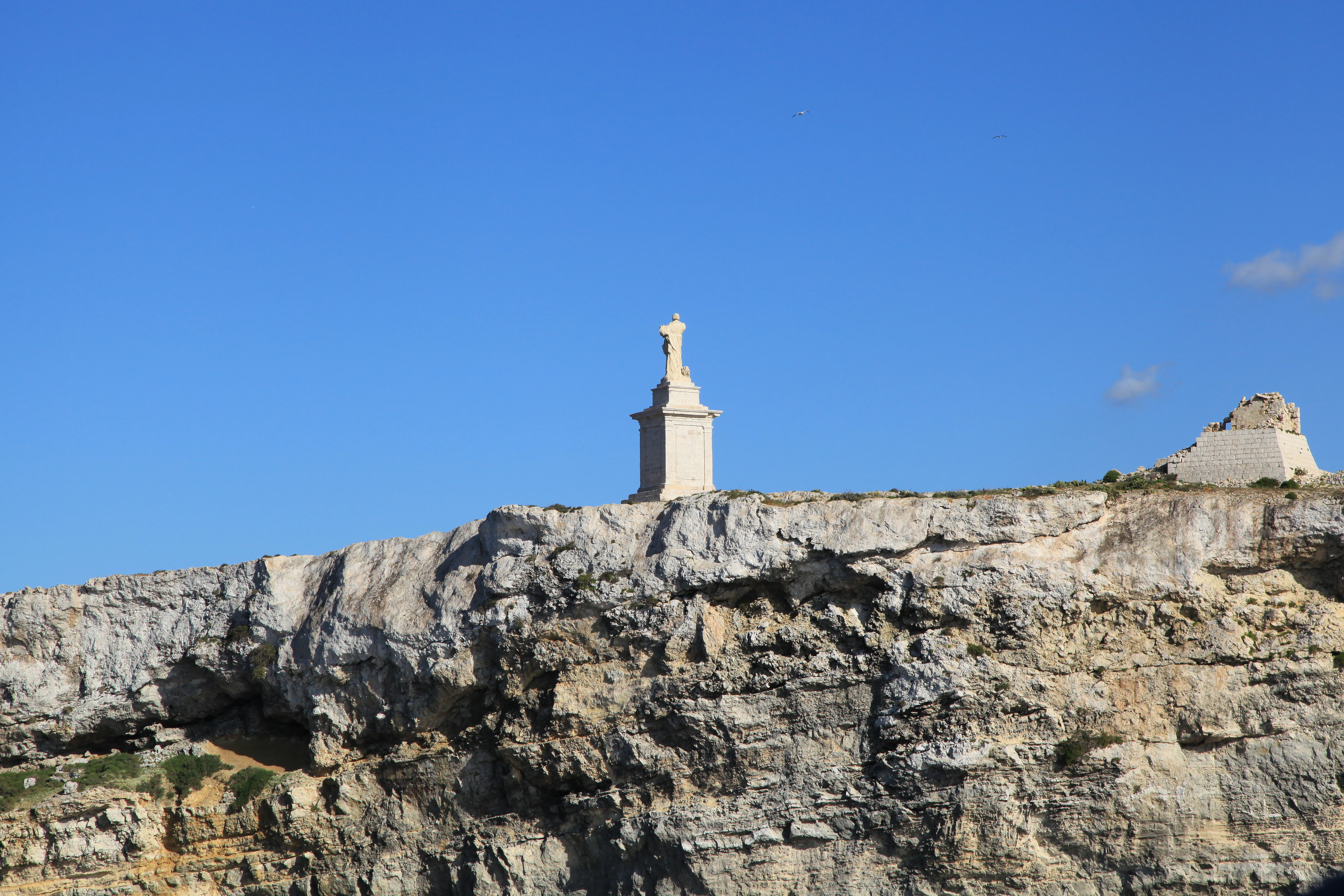
A white statue of St Paul stands atop a limestone cliff on a small island against a clear blue sky.
A view of the St Paul's Statue on the rocky cliffs of St Paul's Island in Malta.

St Paul's Island history and protected-area timeline

The history of St Paul's Island stretches back into the religious foundations of the Maltese narrative. According to tradition, the island was long identified as the location of the Apostle Paul's shipwreck on Malta in 60 AD, an event described in the Acts of the Apostles. More recent archaeological work on the seabed near Salina Bay and around the nearby Roman estate of San Pawl Milqi has suggested that the actual wreck site lies elsewhere along the coast, but the traditional association between the island and the Apostle has remained culturally dominant.

Until the late sixteenth century the islands were recorded on maps under the names Isola Salomone and Isola Salomonetto, after the Salomone family who owned nearby land at Selmun. The Maltese forms Selmun and Selmunett emerged from these older labels. In 1576 Marco di Maria escaped Barbary corsairs off the Maltese coast by navigating through the narrow channel between the island and the mainland, leading to his capture of the pirates and a grant of the island from Grand Master Jean de la Cassière. From this point, the island was locally known as Tal-Barba Marku.

After di Maria's death the island passed through his family and eventually returned to the Order of Saint John. Sometime after 1649, Grand Master Giovanni Paolo Lascaris oversaw the construction of a coastal watchtower on the island, designed along the lines of other Lascaris-period towers around Malta. The tower was exchanged as part of a larger land transaction with Michel de Torellas, the Prior of Catalonia. In 1844 a monumental statue of Saint Paul was erected on the island, sculpted by Segismondo Dimech of Valletta and Salvatore Dimech of Lija, and officially blessed in September 1845. The statue has since been restored multiple times by the heritage organisation Din l-Art Ħelwa.

During the early twentieth century the farmer Vincenzo Borg, nicknamed Ta' Bajdafin, lived on the island and converted the historic tower into a modest farmhouse. He abandoned the dwelling and its fields just before the outbreak of World War II, leaving the tower to fall into ruin, with its upper chamber eventually collapsing. Since then the island has remained uninhabited. Pope John Paul II visited the island by boat during his 1990 visit to Malta, and a submerged statue of Christ known as Kristu tal-Baħħara was placed near the island in the same year before later being relocated to Qawra due to declining underwater visibility.

St Paul's Island landscape and geographic character

St Paul's Island is a low, rocky landmass carved out of Malta's characteristic upper coralline limestone. Its shoreline is short and compact, measuring under one kilometre in total, and is bordered by cliffs that fall directly into the sea on the more exposed sides. The narrow isthmus connecting what are sometimes counted as two separate islets means that, depending on the tide, the island can appear as a single shape or as a pair of low rocks divided by a thin channel.

The larger western portion of the island carries the principal landmarks, including the ruins of the Lascaris tower and the Saint Paul statue, while the smaller eastern islet, known as Quartz Island, is more exposed and carries a thinner layer of vegetation. From the Mellieħa coast the island reads as a low silhouette breaking the otherwise continuous line of the northern Maltese shore, and it forms a distinct visual anchor for the broad embayment associated with St Paul's Bay. The island's small footprint concentrates its entire landscape into a compressed zone of cliff, rock platform, scrub, and historic ruins, giving it a visual density that contrasts with its modest size.
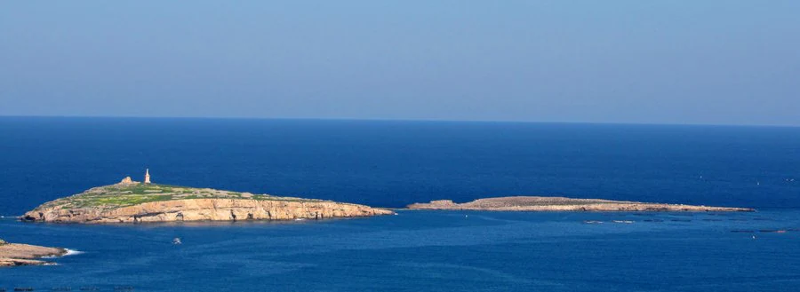
A wide view of St Paul's Island in the Mediterranean Sea, showcasing its elongated, rocky terrain and blue waters.
An aerial view of St Paul's Island off the coast of Malta, featuring its rocky landscape and a prominent monument.

St Paul's Island ecosystems, habitats, and plant life

Ecologically, St Paul's Island supports a classic example of Maltese maritime garigue, a low, aromatic scrub community adapted to wind, salt spray, thin soils, and intense Mediterranean sunshine. The dominant vegetation includes golden samphire, which thrives along the cliff and rock edges, and Maltese fleabane, alongside other hardy coastal species. Together these plants give the island a sparse but characteristic cover that clings to pockets of soil between the limestone outcrops.

The shallows and rock platforms around the island are part of the broader Mediterranean coastal ecosystem that surrounds northern Malta, supporting marine life typical of clear, moderately deep offshore waters. The habitat pattern on St Paul's Island is shaped by exposure, with the more sheltered western side supporting denser vegetation and the smaller islet carrying a thinner plant cover. Although the island's ecological footprint is small, its position just offshore gives it a distinctive microclimate and ecological separation from the mainland, reinforcing its character as a protected natural feature within the Maltese archipelago.
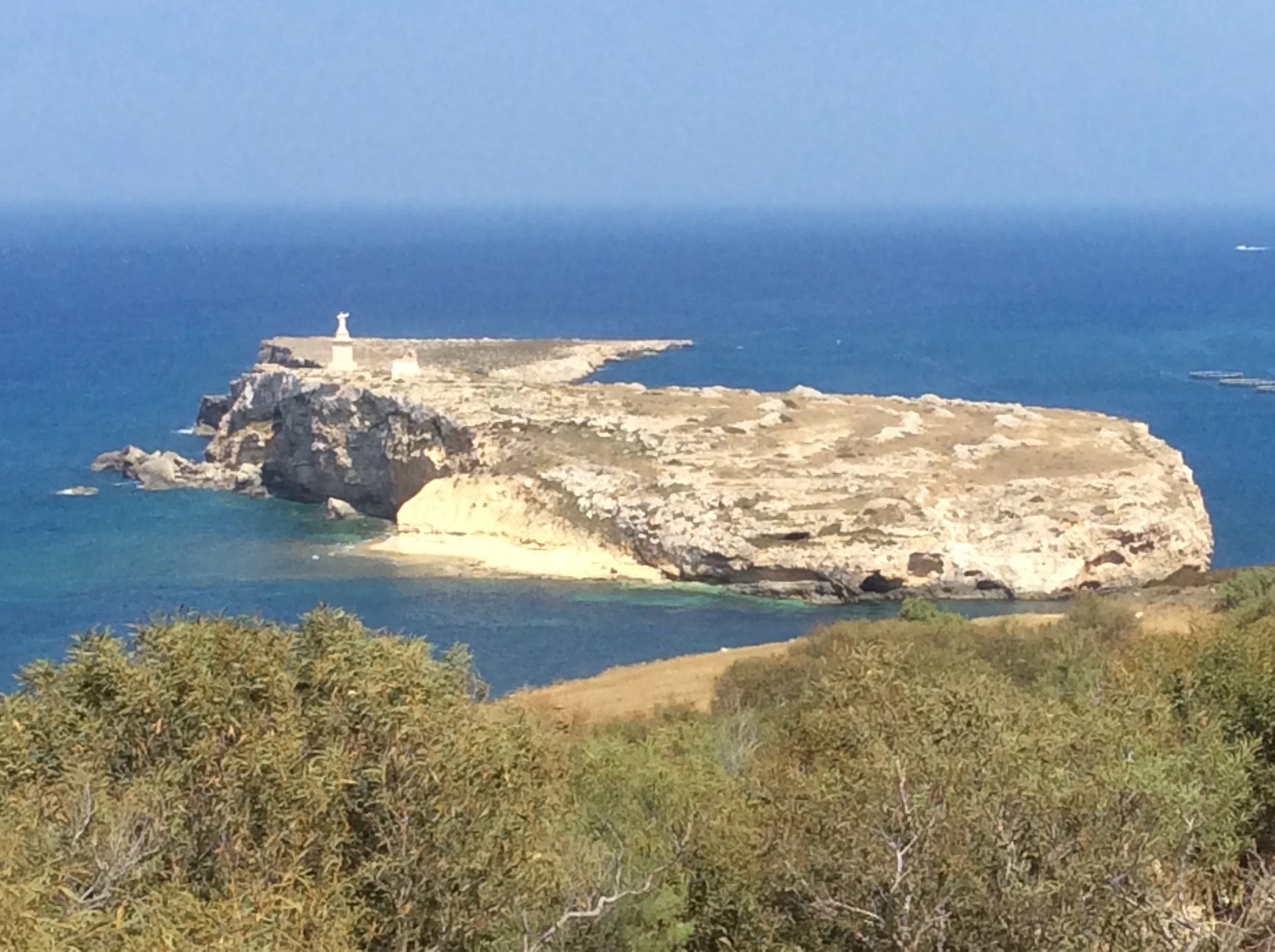
A wide angle view of the arid, rocky St Paul's Island surrounded by blue Mediterranean sea, seen from a distance across the water.
A view of St Paul's Island from the coastline of Mellieha.

St Paul's Island wildlife and species highlights

The wildlife of St Paul's Island is limited in scale but includes some locally notable elements tied to the Maltese island ecosystem. A population of the land snail Trochoidea spratti has been recorded on the islands, reflecting the broader presence of small invertebrates that thrive in Mediterranean garigue habitats. In the past, populations of the Maltese wall lizard, in particular the subspecies Podarcis filfolensis kieselbachi, also lived on the island, although this population is reported to have disappeared in the early twenty-first century.

Rabbits were once present on the island but died out due to disease, illustrating the fragility of small island mammal populations. Today, the island's wildlife character is defined more by its vegetation cover and by the surrounding marine life of the northern Maltese nearshore zone than by its terrestrial fauna. The island's small size and isolation mean that even modest species losses are visibly registered, which has given it a kind of natural archive role for understanding how very small Mediterranean islets change over time.

St Paul's Island conservation status and protection priorities

St Paul's Island's conservation profile lies at the intersection of cultural heritage and small-island ecology. Its monuments, including the mid nineteenth-century statue of Saint Paul and the tower ruins from the Lascaris period, have been the focus of repeated restoration campaigns by the heritage organisation Din l-Art Ħelwa, reflecting the recognition that even a small uninhabited island can carry nationally significant cultural assets.

Ecologically, the island's maritime garigue and its specialised flora represent a compressed example of the coastal habitat types that characterise much of northern Malta. The disappearance of the local wall lizard subspecies underlines how vulnerable such small-island populations can be to disease and other pressures. While St Paul's Island is not a large formal nature reserve, its status as uninhabited land and its continued role as a heritage site mean that it functions as a kind of informal protected area, where cultural, religious, and ecological values are maintained together rather than managed apart.

St Paul's Island cultural meaning and human context

The cultural identity of St Paul's Island is inseparable from the broader Maltese narrative around the Apostle Paul and the Christianisation of the islands. The 1844 statue of Saint Paul on the island is one of the most visible expressions of this connection, and the island is closely tied, at least in tradition, to the canonical story of Paul's arrival on Maltese shores. Nearby features such as St Paul's Bay and the Roman estate at San Pawl Milqi reinforce this cultural geography.

The island also carries a more locally grounded history, including its earlier names Isola Salomone and Selmunett, its association with the Salomone family of Mellieħa, and the vivid episode of Marco di Maria's escape from Barbary corsairs in 1576. These layers of meaning give the island a character that is at once religious, knightly, and deeply local to northern Malta, blending biblical legend with the practical maritime history of an island that has always lived with the sea at its edge.

Top sights and standout views in St Paul's Island

St Paul's Island stands out for combining unusually strong religious symbolism with the kind of compact Mediterranean island landscape that the Maltese archipelago is known for. The nineteenth-century statue of Saint Paul, the ruins of the Lascaris tower, and the dramatic cliffs and maritime garigue vegetation give the island a layered identity in a very small space. Its accessibility from the Mellieħa coast and its visibility from St Paul's Bay also make it one of the most frequently seen uninhabited islands in Malta.

A further standout feature is the way the island's name itself encodes centuries of change, from the older Salomone and Selmunett labels through the Tal-Barba Marku period following Marco di Maria's escape, before the modern association with Saint Paul became fully dominant. This richness of naming, combined with the island's geological simplicity and ecological distinctness, makes St Paul's Island a useful example of how a small Mediterranean landmass can accumulate unusually deep cultural and natural meaning.

Best time to visit St Paul's Island

Because St Paul's Island is uninhabited and viewed largely from the coast or from boat excursions rather than entered as a settlement, the timing of a visit is shaped more by conditions on the surrounding water and on the cliff scenery than by any internal park calendar. The calmer and warmer months of late spring, summer, and early autumn generally offer smoother sea conditions for boat-based views of the island and clearer sightlines from the Mellieħa headlands toward the statue and tower.

Cooler and more variable winter weather tends to bring rougher seas around the northern Maltese coast, which can obscure views of the island's cliffs and limit small-boat access. The flowering period of the island's maritime garigue vegetation, especially with golden samphire and Maltese fleabane, is most visible during the warmer months, when the island's compact ecological character becomes easier to appreciate from offshore viewpoints.
Monthly climate preview

Long-term monthly averages tracking temperature ranges and precipitation rhythm for St Paul's Island

St Paul's Island Climate Normals: Measured Annual Temperature and Precipitation

St Paul's Island records long-term monthly temperature averages spanning from 13.94 degrees Celsius up to 26.58 degrees Celsius alongside measured precipitation rates between 0.14 and 3.02 millimeters per day. Examining the complete twelve-month profile provides detailed meteorological data across all recorded periods for comparative analysis.
Annual mean20 °C
14 °C27 °C
Jan15°
Feb14°
Mar15°
Apr16°
May19°
Jun22°
Jul25°
Aug27°
Sep25°
Oct23°
Nov19°
Dec16°
Warmest month
August

26.6 °C

Coolest month
February

13.9 °C

Wettest month
November

3 mm/day

Driest month
July

0.1 mm/day

Park location guide

Geography guide, regional context, and park location map for St Paul's Island

St Paul's Island park geography, regions, and map view in Malta

Understand where St Paul's Island sits in Malta through a broader geographic reading of the surrounding landscape, nearby location context, and its mapped position within the national park landscape.

How St Paul's Island fits into Malta

Malta is a small island nation in the Mediterranean, located between Italy, Tunisia, and Libya. With a population of about 520,000 spread over 316 km², it is one of the world's most densely populated countries. The country has a long history of foreign rule and is known for its strategic position, historic sites, and membership in the EU, Commonwealth, and UN.

Wider geography shaping St Paul's Island in Malta

Malta is located in the Mediterranean Sea between Sicily and North Africa, approximately 80 km south of Italy, 284 km east of Tunisia, and 333 km north of Libya. The archipelago sits at coordinates 35°54′N 14°31′E.

Map view of St Paul's Island

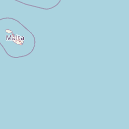
Use this park location map to pinpoint St Paul's Island in Malta, understand its exact geographic position, and read its mapped placement within the surrounding landscape more clearly.

Pigeon | © OpenStreetMap contributors

Explore photographic records of limestone terrain, maritime vegetation, and historic monuments across the uninhabited Maltese islet.

St Paul's Island Photos and Landscapes: Visualizing Limestone Cliffs, Garigue Habitats, and Coastal Scenery

Visual documentation captures the exposed limestone cliffs, sparse maritime garigue habitats, and historic watchtower ruins defining St Paul's Island. Photographic research provides a clear perspective on the rugged terrain, coastal environment, and protected character of the Maltese heritage site.

A white statue of St Paul stands atop a limestone cliff on a small island against a clear blue sky.

A sunny view from the sea looking at a limestone cliff on St Paul's Island, featuring a prominent white statue on the ridgeline.

A wide view of St Paul's Island in the Mediterranean Sea, showcasing its elongated, rocky terrain and blue waters.

A wide angle view of the arid, rocky St Paul's Island surrounded by blue Mediterranean sea, seen from a distance across the water.

Park atlas

Compare surrounding coastal landscapes and regional nature reserves

Explore Protected Areas and Parks Near St Paul's Island in Malta

Browse nearby national parks and protected coastal environments that share the rugged limestone geology of northern Malta. Extending your geographic comparison beyond St Paul's Island reveals the wider pattern of Mediterranean marine reserves and rocky island habitats.
A horizontal watercolor painting showing soft green hills, grassy marshland, and a calm water channel under a light, hazy sky.
Nature reserveGozo
About 7.7 km away#1 closest

Northwest

Comino Nature Reserve: Geography, Protected Marine Areas, and Karst Terrain in Gozo

Island ecology and coastal landscape mapping

Examine the protected geography of Comino, an island nature reserve near Gozo defined by limestone plateaus and sheltered bays. This overview covers the ecological boundaries of the Natura 2000 marine area, the distribution of coastal sea caves, and the topographic patterns of this Important Bird Area.

Area
3.5 km²
Relief
Lowland
Climate
Mediterranean
Access
Moderate access
National parkMalta
About 8.3 km away#2 closest

South

Ta' Qali National Park: Malta's Largest Urban Protected Landscape and Recreation Hub

Mapped Gardens, Event Venues, and Recreational Zones

Ta' Qali National Park serves as a vital green lung in central Malta, showcasing a landscape transformed from a wartime airfield into a modern urban protected area. This national park is recognized for its extensive recreational zones, meticulously designed formal gardens, and a prominent open-air concert venue that hosts major cultural events. Its relatively flat terrain and planned infrastructure offer a distinct map-based perspective on urban parkland, highlighting its significance as a major public amenity and a key feature of Malta's landscape.

Area
0.35 km²
IUCN
V
Relief
Lowland
Climate
Mediterranean
A horizontal watercolor painting depicting a soft-toned, abstract coastal landscape with gentle green hills, grassy foreground patches, and a calm, pale pool of water against a white background.
Marine protected areaMalta
About 9.2 km away#3 closest

Southwest

Ras ir-Raħeb Marine Protected Area: Geographic Profile and Mapped Coastal Landscape

Coastal cliffs and protected marine zones in north western Malta.

Ras ir-Raħeb serves as a pivotal marine protected area along the Malta coastline, where high limestone cliffs meet complex underwater habitats. This site links historical archaeological remnants with modern ecological conservation, offering a unique geographic snapshot of the Rabat plateau edge. Its mapped boundaries encompass both the terrestrial promontory and the essential seagrass meadows beneath the surface, providing a critical reference point for Mediterranean coastal geography and protected land status.

Established
2005
Relief
Upland
Climate
Mediterranean
Access
Moderate access
A soft, pastel-toned watercolor painting of a rolling green landscape with a small body of water in the foreground and a silhouette of a building on a hill in the distance.
Wildlife reserveMalta
About 12 km away#4 closest

South

Buskett Gardens Wildlife Reserve: Geography and Protected Landscape Map of Malta

A rare sheltered woodland valley in the central Mediterranean

Buskett Gardens serves as a critical protected woodland in the heart of the Maltese islands. Nestled in the fertile Wied il-Luq valley, the site offers an unusually green, shaded environment of broadleaved trees and conifers. This reserve functions as an Important Bird Area and a historic cultural landscape, providing a lush contrast to the exposed limestone plateau of rural Malta.

Area
0.47 km²
Relief
Upland
Scope
Terrestrial
Water
Minor water
A flat-style vector illustration depicting a coastal beach scene with reddish sand, rolling green hills in the background, a blue ocean with gentle waves, and a few beach umbrellas in the foreground.
Protected areaGozo
About 15 km away#5 closest

Northwest

Ramla Bay: Geographic Mapping and Protected Landscape Analysis of the Gozo Coast

Coastal terrain, red-sand geology, and Mediterranean rural landscapes.

Ramla Bay represents a significant protected coastal pocket on the island of Gozo. Beyond its well-known red-sand beach, the area encompasses a wider valley landscape defined by limestone headlands and agricultural plateaus. Use this mapped overview to understand the interaction between the Mediterranean coastline and the rugged rural hinterland of the Maltese islands.

Relief
Lowland
Climate
Mediterranean
Access
Easy access
Scope
Terrestrial
A horizontal watercolor illustration showing soft, blended washes of green, yellow, and pale pink depicting an abstract rolling landscape or horizon line against a white background.
Natural monumentMalta
About 18 km away#6 closest

Southeast

Għar Dalam Natural Monument: A Protected Maltese Cave and Paleontological Landmark

Geological and prehistoric landscape context in southeastern Malta

Għar Dalam is a protected natural monument in Malta that preserves a complex phreatic cave passage and essential fossil records of extinct dwarf species. This cave site acts as a major cornerstone for understanding the prehistoric Mediterranean, documenting the arrival of early Neolithic cultures and the long-term evolution of island-bound animal life through stratified sediment analysis.

Established
1933
Relief
Lowland
Climate
Mediterranean
Access
Easy access
A watercolor painting showing a soft landscape with green rolling hills, low vegetation, and a calm water surface against a pastel sky.
Nature reserveSouth Eastern Region
About 19 km away#7 closest

Southeast

Il-Ballut ta' Marsaxlokk Nature Reserve: Geography and Protected Wetland Landscapes

Essential salt marsh habitat in Malta's South Eastern Region

Il-Ballut ta' Marsaxlokk serves as a critical protected area, preserving a rare salt marsh landscape within the coastal environment of Malta. This reserve features a compact mosaic of muddy canals, halophytic vegetation, and Mediterranean coastal terrain. Its inclusion in the Natura 2000 network highlights its regional importance as a refuge for migratory birds and a focal point for environmental conservation in the South Eastern Region.

Area
0.23 km²
Established
2018
IUCN
IV
Relief
Lowland
A pale, minimalist watercolor illustration showing soft, rolling green and yellow hills against a white background.
Nature reserveMalta
About 20 km away#8 closest

South

Filfla Nature Reserve: The Protected Limestone Plateau and Geography of Malta

Tracing the limestone cliffs and seabird sanctuary of the Maltese archipelago

Filfla is a small, uninhabited limestone islet lying 4.5 kilometres south of the main island of Malta. Defined by its 60-metre sea cliffs and flat plateau, this protected nature reserve functions as a crucial Important Bird Area and a landmark for regional Mediterranean biodiversity. Examine the mapped boundaries and geological profile of this site to understand its status as the southernmost extremity of the Maltese archipelago.

Area
0.06 km²
Established
1980
Relief
Upland
Climate
Mediterranean

Common questions about visiting, size, designation, and location context for St Paul's Island

St Paul's Island FAQs for park facts, access, geography, and protected area context

Find quick answers about St Paul's Island, including protected-area facts, park geography, trail and visitor context, and how the park fits into its surrounding country and regional landscape.
MoriAtlas Explorer

Continue Your Protected Areas Search Across the Global Atlas

Deepen your exploration by continuing the structured search for national parks and protected areas worldwide. Utilize the comprehensive filtering capabilities to compare different conservation landscapes and refine your understanding of global park geography. Discover more about the distribution and characteristics of protected natural areas.

Global natural geography