

Mori Atlas logo
National parkTakamanda National Park

Discover the mapped boundaries and regional setting of Takamanda National Park in Cameroon.

Takamanda National Park: Cameroon's National Park Protected Landscape and Geographic Context

Takamanda National Park represents a significant protected landscape within Cameroon's diverse geography. As a designated national park, it offers crucial insights into the country's natural heritage and conservation efforts. Users can explore its mapped boundaries and understand its placement within the broader regional atlas, uncovering the distinct geographic and landscape characteristics that define this protected area in Central Africa.

Cross River gorilla protectionMountain forest ecosystemCritical conservation areaPrimate habitatTransboundary protected areaCameroon highlands

Takamanda National Park

National park

Park overview

Structured park overview, official facts, and landscape profile for Takamanda National Park

Takamanda National Park park facts, protected area profile, and essential visitor context

Review the core facts for Takamanda National Park, including designation, size, terrain, visitor scale, habitats, and operating context in one park-focused overview.

About Takamanda National Park

Takamanda National Park sits in the heart of the Mbe Mountains in Cameroon's Southwest Region, within the Manyu department. The protected area was created in 2008 specifically to provide stronger legal protection for the endangered Cross River gorilla and its habitat, elevating its status from the earlier Forest Reserve designation that had existed since 1934. The park forms part of a broader transboundary conservation landscape that includes adjacent protected areas in Nigeria, recognizing that the gorilla populations and their habitat cross international borders. The local communities have lived in and around the forest for generations, with approximately 43 villages located within what is now the national park boundary. The mountainous terrain creates a diverse ecological setting ranging from lower slopes to higher elevation forest zones, supporting varied plant communities and the wildlife that depends on them. The park represents one of the last remaining strongholds for the Cross River gorilla, a species that has been pushed to the brink of extinction by habitat loss, hunting, and human-wildlife conflict.

Quick facts and research context for Takamanda National Park

Takamanda National Park is located in the Southwest Region of Cameroon, specifically in the Manyu department. The protected area was formally established as a national park in 2008, succeeding the Takamanda Forest Reserve which was created in 1934. The park encompasses mountainous terrain within the Mbe Mountains and supports a local population of approximately 16,000 residents distributed across about 43 villages. The primary conservation focus is the protection of the Cross River gorilla, one of the world's rarest gorilla subspecies. The ecosystem supports diverse wildlife including multiple monkey species, wild pigs, small antelopes, and numerous bird species.

Protection and recognition

Documenting terrestrial management scope and official designations in the global network

Takamanda National Park Protection Status and Protected Area Designation

Map-based database records trace the official terrestrial protection status and conservation framework established for Takamanda National Park. Researchers can analyze the documented administrative boundaries and formal designation data to understand how the habitat fits into regional preservation systems.

Protection details

Protection scope
Terrestrial
Transboundary protection
No
Park context

Deeper park guide and search-rich context for Takamanda National Park

Takamanda National Park history, landscape, wildlife, and travel context

Explore Takamanda National Park through its history, landscape character, ecosystems, wildlife, conservation priorities, cultural context, and seasonal travel timing in a structured park guide built for atlas discovery and search intent.

Why Takamanda National Park stands out

Takamanda National Park is best known as a critical stronghold for the Cross River gorilla, the rarest gorilla subspecies in the world with fewer than 300 individuals remaining. The park's mountainous forest habitat within the Mbe Mountains provides essential protection for this endangered primate and the broader biodiversity of the region. Beyond the gorillas, the park supports exceptional primate diversity with several monkey species, making it one of the most important areas for primate conservation in Central Africa. The combination of highland forest, diverse wildlife communities, and its role in protecting a globally threatened species defines the park's distinctive conservation identity.

Takamanda National Park history and protected-area timeline

The protection history of Takamanda dates back to 1934 when the area was established as the Takamanda Forest Reserve, covering approximately 675.99 square kilometers. This early designation reflected the colonial administration's recognition of the region's valuable forest resources and the need for sustainable management. For over seven decades, the Forest Reserve provided a baseline of protection, though the level of enforcement and actual conservation outcomes varied over time. In 2008, the Cameroon government elevated the protected area to national park status, a significant upgrade that brought stronger legal protections and increased focus on the conservation of endangered species, particularly the Cross River gorilla. This transition reflected the growing understanding of the area's global significance for biodiversity conservation, especially for species with extremely limited ranges. The establishment as a national park also aligned with broader regional efforts to protect the Cross River gorilla population, which spans the Cameroon-Nigeria border region.

Takamanda National Park landscape and geographic character

The landscape of Takamanda National Park is dominated by the Mbe Mountains, a range of rugged hills and forested peaks that rise from the surrounding lowland terrain. The topography creates a variety of habitats, from moist lower slopes covered in dense tropical forest to higher elevation zones with different vegetation assemblages. The mountain environment supports streams and drainage systems that flow through the forest, providing water resources for both wildlife and local communities. The terrain varies from steep slopes to more gentle ridges, creating microclimates and diverse ecological niches throughout the park. Forest cover is generally dense, with the vegetation ranging from lowland rainforest at lower elevations through to montane forest communities at higher altitudes. The combination of elevation range, forest types, and the structural complexity of the vegetation creates a landscape of considerable ecological value.

Takamanda National Park ecosystems, habitats, and plant life

The nature of Takamanda National Park centers on its role as a critical biodiversity refuge in the Congo Basin margin. The park's forest ecosystems support a remarkable concentration of wildlife, with particular importance for primates. The montane and lowland forest habitats create conditions suitable for multiple species that have specific habitat requirements. The vegetation includes various forest types that have evolved in response to the elevation gradient and local climate patterns. The park's location within the broader Cross River basin region places it at the intersection of different ecological zones, contributing to species diversity. The forest structure provides essential resources including food plants, nesting sites, and movement corridors for the wildlife communities that inhabit the area.

Takamanda National Park wildlife and species highlights

The wildlife of Takamanda National Park is characterized by exceptional primate diversity, with the Cross River gorilla as the flagship species. This gorilla subspecies is among the most endangered primates in Africa, with Takamanda serving as one of its most important remaining habitats. Several monkey species share the forest with the gorillas, creating a diverse primate community. The mammal fauna also includes wild pigs and small antelopes, representing different feeding guilds and ecological roles within the ecosystem. Birdlife is particularly diverse, with many species inhabiting the forest canopy and understory. The combination of forest types and the mountain environment supports this rich fauna, making the park important for maintaining viable populations of species that have suffered significant range contractions across their historical distributions.

Takamanda National Park conservation status and protection priorities

Takamanda National Park represents one of the most important conservation areas in Central Africa due to its role in protecting the Cross River gorilla. The subspecies is listed as critically endangered by global conservation authorities, making every protected population significant for the species' survival. The park's elevation from Forest Reserve to National Park status in 2008 reflected increased recognition of its global conservation importance. The park forms part of a transboundary conservation network with neighboring protected areas in Nigeria, acknowledging that gorilla populations and their habitat extend across international borders. Conservation challenges include managing the relationship between local communities and wildlife, particularly where human activities can impact gorilla habitat or create conflict situations. The presence of approximately 43 villages within and adjacent to the park requires careful balancing of conservation objectives with the livelihood needs of local populations.

Takamanda National Park cultural meaning and human context

Takamanda National Park is home to local communities who have inhabited the forest region for generations, with approximately 43 villages existing within the park's boundaries and surrounding area. The local population of around 16,000 people maintains traditional connections to the land and resources of the region. These communities have developed relationships with the forest environment that include both resource use and cultural practices tied to the landscape. The establishment of the national park has created ongoing interactions between conservation management and community livelihoods, requiring approaches that recognize both the need for species protection and the rights and needs of local residents. The region is part of the broader cultural landscape of Cameroon's Southwest Region, with local communities holding knowledge of the forest and its wildlife that spans many generations.

Top sights and standout views in Takamanda National Park

Takamanda National Park's primary highlight is its role as a sanctuary for the Cross River gorilla, the world's rarest gorilla subspecies with fewer than 300 individuals remaining. The park's location in the Mbe Mountains provides critical highland forest habitat that serves as a refuge for this endangered primate and the broader biodiversity of the region. The transition from Forest Reserve to National Park in 2008 marked the park's elevated conservation status and global significance. The mountain forest landscape creates a distinctive setting among Cameroon's protected areas, supporting diverse wildlife including multiple monkey species, wild pigs, antelopes, and abundant birdlife. The park's position as part of a transboundary conservation landscape connecting Cameroon and Nigeria reflects the reality that great ape populations require protection across international boundaries.

Best time to visit Takamanda National Park

The best time to visit Takamanda National Park is during the dry season months, typically from November to April, when rainfall is reduced and trail conditions are more favorable for exploration. During this period, wildlife viewing opportunities may improve as animals congregate around remaining water sources and vegetation becomes less dense. The dry season offers more comfortable conditions for hiking through the mountainous terrain. However, visitors should be prepared for variable mountain weather and should expect some rainfall even during the dry season. The wet season, from May to October, brings heavier rainfall that can make trails slippery and some areas difficult to access, though the forest becomes lusher and bird activity increases. Year-round visits require appropriate gear for forest conditions and mountain weather.
Monthly climate preview

Long-term temperature ranges and monthly precipitation averages for Cameroon

Takamanda National Park Climate Normals and Annual Weather Patterns

Takamanda National Park records documented monthly temperature fluctuations alongside distinct seasonal shifts in precipitation across the representative coordinate. Reviewing the complete twelve-month climate profile provides detailed historical baseline data for analytical conservation research.
Annual mean25 °C
23 °C26 °C
Jan25°
Feb26°
Mar26°
Apr26°
May25°
Jun24°
Jul23°
Aug23°
Sep24°
Oct24°
Nov25°
Dec25°
Warmest month
March

26 °C

Coolest month
August

23.2 °C

Wettest month
September

10.9 mm/day

Driest month
December

0.2 mm/day

Park location guide

Geography guide, regional context, and park location map for Takamanda National Park

Takamanda National Park park geography, regions, and map view in Cameroon

Understand where Takamanda National Park sits in Cameroon through a broader geographic reading of the surrounding landscape, nearby location context, and its mapped position within the national park landscape.

How Takamanda National Park fits into Cameroon

Cameroon is a Central African country spanning coastal, highland, and forest regions. It has a population of nearly 31 million people who speak 250 native languages alongside English and French as official languages. The country gained independence from France in 1960 and unified with British Southern Cameroons in 1961.

Wider geography shaping Takamanda National Park in Cameroon

Cameroon is located in Central Africa, bordering Nigeria and Chad to the west and north, the Central African Republic to the east, and Equatorial Guinea, Gabon, and the Republic of the Congo to the south. The country has a coastline on the Bight of Biafra, part of the Gulf of Guinea. Terrain includes coastal plains, mountainous highlands (including Mount Cameroon), plateaus, and dense rainforest regions.

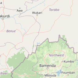
Map view of Takamanda National Park

Use this park location map to pinpoint Takamanda National Park in Cameroon, understand its exact geographic position, and read its mapped placement within the surrounding landscape more clearly.

Pigeon | © OpenStreetMap contributors

Location context for Takamanda National Park

Manyu
Park atlas

Explore Regional Protected Landscapes and Connect the Geography Surrounding Takamanda National Park

Discover Nearby Protected Areas and National Parks Near Takamanda National Park

Browse national parks and protected areas adjacent to Takamanda National Park, revealing similar mountain forest ecosystems and vital transboundary conservation landscapes. Compare geographic contexts, trace regional ecological corridors, and understand the spread of critical primate habitats for deeper atlas-style discovery.
Watercolor illustration of a forested landscape with pink flowering plants, a winding river, and mountain ranges in the background
National parkCameroon
62 km away#1 closest

Southwest

Korup National Park: Cameroon's Ancient Tropical Rainforest Protected Area Exploration

Explore its rich biodiversity and unique geographic landscape.

Korup National Park is a significant protected area in Cameroon, covering 1,260 square kilometers of what is considered one of Africa's oldest and most biodiverse tropical rainforests. Established in 1986, this national park is renowned for its exceptional primate populations, extensive plant species, and its role as a critical conservation landscape. The park's terrain transitions from lowlands to hilly areas, with a dense network of streams, offering a rich subject for geographic and protected-area study.

Area
1,260 km²
Established
1986
IUCN
II
Relief
Mixed relief
National parkCross River State
About 67 km away#2 closest

Southwest

Cross River National Park National Park: Mapped Protected Landscape and Regional Geography

Explore the geographic features and protected area context.

Cross River National Park represents a key protected area within Nigeria, offering valuable insights into its specific landscape and regional geographic setting. This entry focuses on the park's identity as a national park, detailing its mapped boundaries and its role within the broader geography of Cross River State. Users can engage with structured data to understand the park's physical context and its significance as a protected natural landscape, supporting detailed atlas-based exploration.

Area
4,000 km²
Established
1991
IUCN
II
Relief
Mixed relief
National parkNorth-West Region
About 88 km away#3 closest

Northeast

Kimbi-Fungom National Park: Mapping Protected Forest and Watershed Geography

Essential habitats in Cameroon's North-West Region

Kimbi-Fungom National Park offers a distinct geographic profile, bridging the Bamboutos Mountains with low-lying savanna mosaics and riverine wetlands. This protected landscape is fundamental for the conservation of rare primate communities and the regulation of the Katsina Ala River, which feeds major water infrastructure. Gain insight into the terrain characteristics and ecological boundaries of this significant protected area through detailed mapping and regional context.

Area
657 km²
Established
2015
Relief
Mountain
Climate
Tropical
National parkCameroon
99 km away#4 closest

South

Bakossi National Park: Detailed Protected Area Map and Geographic Identity in Cameroon

Explore the mapped landscape and regional context of this Cameroonian national park.

Bakossi National Park is an important protected area situated within Cameroon, functioning as a national park dedicated to conservation and geographic study. This page provides essential details on its mapped boundaries, regional setting, and the natural landscape it represents. It serves as a foundational element for understanding protected areas in Central Africa and their broader geographical significance.

Area
293.2 km²
Established
2008
Relief
Mountain
Climate
Tropical
National parkCameroon
About 196 km away#5 closest

South

Mount Cameroon National Park: A National Park within Cameroon's Geographic Atlas

Explore its protected landscape and mapped terrain.

This dedicated entry for Mount Cameroon National Park provides essential atlas-based information for understanding its significance as a protected area. Users can explore the park's geographic identity, mapped boundaries, and its role within the diverse landscapes of Cameroon. Gain structured insight into the natural terrain and protected land context that defines this national park, offering a clear view of its atlas-relevant features.

National parkTaraba State
212 km away#6 closest

Northeast

Gashaka Gumti National Park: A Deep Dive into Nigeria's Largest Protected Geographic Territory

Mapping the rugged terrain and ecological zones of Taraba State

Spanning over 6,000 square kilometers, Gashaka Gumti National Park is a massive protected expanse that defines the geographic character of northeastern Nigeria. The park integrates diverse environmental zones, including expansive savanna plains and the dramatic slopes of the Chappal Waddi mountain range. This protected area acts as a crucial node for regional biodiversity and remains a central feature in the mapped geography of Taraba State, offering a rare look at Nigeria's vertical landscape transition.

Area
6,402 km²
Established
1991
IUCN
II
Visitors
445 annual
National parkCameroon
222 km away#7 closest

South

Douala-Edéa National Park: Coastal Mangrove and Tropical Forest Protected Landscape

Explore Cameroon's vital protected national park geography.

Douala-Edéa National Park is a protected national park in Cameroon's Littoral Region, defined by its extensive coastal geography where tropical lowland equatorial forests merge with significant Atlantic mangrove ecosystems. This area, encompassing roughly 2,715 square kilometers along the Bight of Biafra and the Sanaga River estuary, offers rich context for understanding Central Africa's coastal protected lands and diverse natural landscapes.

Area
2,715.12 km²
Established
2018
IUCN
II
Relief
Lowland
National parkNigeria
About 252 km away#8 closest

Northeast

Gashaka-Gumti National Park: Geography and Protected Landscape Atlas of Nigeria

Explore mountain peaks, savanna plains, and watershed ecosystems

Gashaka-Gumti National Park serves as a centerpiece of Nigerian conservation, covering an expansive range of topographical features. This protected area connects the West African savanna zone with Central African highland ecosystems, creating a unique environment defined by deep river gorges, high-altitude ridges, and vital forest corridors that define the regional geography.

Area
6,402 km²
Established
1991
Relief
Mixed relief
Climate
Subtropical

Common questions about visiting, size, designation, and location context for Takamanda National Park

Takamanda National Park FAQs for park facts, access, geography, and protected area context

Find quick answers about Takamanda National Park, including protected-area facts, park geography, trail and visitor context, and how the park fits into its surrounding country and regional landscape.
MoriAtlas Explorer

Continue Your Protected Areas Search Across the Global Atlas

Deepen your exploration by continuing the structured search for national parks and protected areas worldwide. Utilize the comprehensive filtering capabilities to compare different conservation landscapes and refine your understanding of global park geography. Discover more about the distribution and characteristics of protected natural areas.

Global natural geography
