
Islands
Park geography
Analyzing the coastal landscape, regional environment, and terrain characteristics
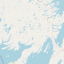
Detailed Geographic Profile and Mapped Boundaries of Terra Nova National Park
This geographic profile details the physical scope of Terra Nova National Park, covering an area of 399 square kilometers in Newfoundland and Labrador. Explore the intersection of boreal forests, wetlands, and coastal cliffs across this region. The analysis includes structural data on boundaries, spans, and a collection of named capes and viewpoints within the park.
Related tags
Boreal ForestCoastal LandscapeEndemic WildlifeBonavista BayEastern Canada
Newfoundland's first national park protecting boreal forest and coastal wilderness along Bonavista Bay
Terra Nova National Park
Terra Nova National Park is Canada's newest national park, established in 1957 as the first national park in Newfoundland and Labrador. Located on the rugged northeast coast of Newfoundland island along several inlets of Bonavista Bay, the park encompasses approximately 399 square kilometers of diverse boreal landscape. The park's name derives from the Latin designation for Newfoundland and represents the original Portuguese name given to the region during early European exploration. The landscape showcases the characteristic terrain of Newfoundland's northeast coast, featuring remnants of the Appalachian Mountains that create widely varied and rugged topography throughout the region. The park protects the Eastern Island Boreal Forest natural region, a significant ecological area covering most of eastern Newfoundland and characterized by extensive black spruce forests with pockets of mixed deciduous species including balsam fir, white pine, mountain ash, tamarack, and maple.
- Location
- Canada
- Park type
- National park
- Established
- 1957
- Area
- 399 km²
Location overview
Island and Coastal Park Status in Newfoundland and Labrador
Mapping the Geography of Terra Nova National Park in Canada
Terra Nova National Park belongs to the province of Newfoundland and Labrador within the nation of Canada. Verified geographic records highlight its status as an established coastal, island, and marine area.
- Countries
- Canada
- Regions
- Newfoundland and Labrador
- Primary location
- Newfoundland and Labrador
- Geographic setting
- Coastal · Island · Marine
Boundary and coordinates
Interactive protected perimeter and spatial measurements
Terra Nova National Park Boundary Map and Geographic Extent
Mapped boundary geometry delivers clear spatial context for the protected area. Accompanying facts outline the total surface coverage, perimeter length, and geographic coordinates.
- Boundary area
- 525.4 km²
- Boundary perimeter
- 123.9 km
- Northernmost point
- 48.6581° N
- Southernmost point
- 48.3857° N
- Easternmost point
- 53.6714° W
- Westernmost point
- 54.2138° W
- Geographic centre
- 48.5318° N, 53.9352° W
- North–south span
- 30.3 km
- East–west span
- 40.1 km
Terrain and natural features
Mixed relief classification and recorded coastal water features
Terra Nova National Park Terrain and Named Natural Features
Stored terrain classifications document mixed relief across the protected landscape alongside recorded named natural features within the boundaries. Linked feature cards supply specific names, types, and spatial relationships for geographic verification.
Selected named natural features
Islands
Newfoundland
Ponds
Southwest Pond
Capes
Hurloc Head
Bays
Dumpling Cove
Bays
Bread Cove
Environmental setting
Boreal climate zones, dominant forest cover, and diverse coastal habitats
Environmental Setting and Landscape Classifications of Terra Nova National Park
Recorded landscape features, habitat types, and seasonal classifications provide structured ways to examine the physical setting of Terra Nova National Park. Associated atlas entries link these stored environmental categories to relevant regional geographies.
- Relief
- Mixed relief
- Climate
- Boreal
- Water
- Major water bodies
- Forest cover
- Dense forest cover
- Seasonality
- Seasonal
Landscape features
Hills · Forest · Wetland · Lakes · Rivers · Coast · Cliffs · Glacier
Habitat types
Boreal forest · Wetland · Riverine habitat · Lacustrine habitat · Coastal habitat · Marine habitat
Park atlas
Map the protected area geography, comparing Newfoundland's unique boreal forests and coastal zones.
Compare Terra Nova National Park with Nearby Protected Areas and Regional Parks
Browse national parks and other protected areas situated near Terra Nova National Park, covering the rich boreal forests and rugged coastal landscapes of Newfoundland. Compare these conservation landscapes to trace regional geographic patterns, ecological distinctions, and the broader spread of protected zones across the Atlantic region.
National parkCanada
266 km away#1 closest
Northwest

Gros Morne National Park: A Canadian National Park for Geographic Exploration
Discover its mapped protected boundaries and regional landscape context.
Explore Gros Morne National Park, a designated National Park within Canada, offering deep insights into its protected landscape and geographic significance. This page details its mapped boundaries and natural terrain, providing essential context for understanding its role within Canada's broader atlas of protected areas. Engage with the specific geography of this park to deepen your knowledge of natural landscapes and conservation.
- Area
- 1,805 km²
- Established
- 2005
- IUCN
- II
- Relief
- Mountain
Wildlife reserveQuebec
About 382 km away#2 closest
Northwest
Baie-de-Brador Migratory Bird Sanctuary: Mapped Geography and Protected Landscapes
A remote wildlife reserve in the Gulf of St. Lawrence.
Located near the Lower North Shore of Quebec, this protected area spans both land and sea to preserve critical colonial seabird habitats. The site features the rocky islands of Île aux Perroquets and Île Greenly, set within a marine buffer zone that reflects the cold, subarctic character of the Atlantic corridor.
- Area
- 5.59 km²
- Established
- 1925
- IUCN
- Ia
Wildlife reserveFrance
About 464 km away#3 closest
West

Réserve nationale de faune de l'Île-Saint-Paul Wildlife Reserve and Regional Geography
Mapping the protected landscapes of France
The Réserve nationale de faune de l'Île-Saint-Paul provides a focused look at isolated terrain and coastal environmental protection. As a designated wildlife reserve in France, it offers a distinct opportunity to study boundary-driven conservation and regional geography through a mapping perspective that highlights its remote natural character.
- Established
- 2025
- Relief
- Lowland
- Climate
- Temperate
- Access
- Access unknown
Wildlife reserveQuebec
480 km away#4 closest
Northwest
Refuge d'oiseaux migrateurs de la Baie-des-Loups Protected Area and Coastal Map
Marine-focused wildlife reserve on the Quebec coast
This wildlife reserve protects essential island and offshore foraging grounds in the Gulf of St. Lawrence. Its geography highlights the intersection of protected land and marine environments, creating a critical habitat for North Atlantic seabird populations along the Quebec lower North Shore.
- Area
- 38.72 km²
- Established
- 1925
- IUCN
- Ia
National parkNova Scotia
492 km away#5 closest
West
Cape Breton Highlands National Park: Mapped Protected Landscape in Nova Scotia
Discover its national park geography and natural terrain.
Uncover the protected landscape identity of Cape Breton Highlands National Park, a national park situated in Nova Scotia. This atlas-focused content details its mapped boundaries, regional geographic context, and natural terrain. It serves as a definitive resource for understanding the park's protected-area status and its contribution to the mapped natural landscapes of the region.
- Area
- 949 km²
- Established
- 1936
- IUCN
- II
- Visitors
- 277.2K annual
Wildlife reserveNova Scotia
About 498 km away#6 closest
Southwest
Réserve nationale de faune du Lac-Big Glace Bay: Coastal Geography and Protected Land Map
Wildlife reserve and coastal sanctuary in Nova Scotia
This protected area centers on a brackish coastal lagoon and a dynamic barrier beach system on the Atlantic coast of Nova Scotia. The reserve provides a critical migratory stopover for waterfowl, with terrain that transitions from exposed sandy shores to regenerated coastal forests on reclaimed land, offering a unique example of maritime ecological restoration.
- Area
- 3.9 km²
- Established
- 2022
- IUCN
- IV
- Relief
- Lowland
Wildlife reserveQuebec
About 547 km away#7 closest
West
Réserve nationale de faune de la pointe de l'Est: Quebec Coastal Wildlife Reserve Atlas
A mapped complex of parabolic dunes, lagoons, and migratory bird habitats
Located on the Magdalen Islands, Réserve nationale de faune de la pointe de l'Est safeguards an exceptional coastal landscape defined by wind-shaped barrier spits and extensive sand dunes. This protected area offers critical insight into the geography of the Gulf of Saint Lawrence, protecting diverse habitats ranging from salt marshes to rare parabolic dune formations and freshwater wetlands.
- Area
- 7.2 km²
- Established
- 1978
- IUCN
- III
- Relief
- Lowland
National parkNewfoundland and Labrador
576 km away#8 closest
Northwest
Mealy Mountains National Park Reserve: National Park Protected Landscape and Map Boundaries
Explore the geography and natural terrain of Newfoundland and Labrador.
Mealy Mountains National Park Reserve represents a key protected landscape within Newfoundland and Labrador, offering detailed insights for atlas-based discovery. This national park's geographic scope and mapped boundaries are crucial for understanding its regional context and natural terrain. Explore the structured facts and landscape characteristics that define this significant protected area, providing a clear view of its protected-land identity.
- Area
- 10,700 km²
- Established
- 2015
- IUCN
- II
- Relief
- Mountain
MoriAtlas Explorer
Continue Exploring Terra Nova National Park's Geographic and Landscape Context
Deepen your understanding of Terra Nova National Park by examining its specific location within Newfoundland and Labrador's mapped terrain. Discover how its protected landscape contributes to the broader atlas of Canadian natural areas and explore its unique geographic attributes for informed discovery.
Browse next
Global natural geography
Explore related park routes
Explore MoriAtlas Global ParksBrowse All MoriAtlas ParksGlobal Park Map DiscoveryMoriAtlas: Browse All CountriesBrowse All MoriAtlas ContinentsNational Park Environment AtlasGrand Canyon National Park AtlasYellowstone National Park AtlasYosemite National Park Atlas and GeographySerengeti National Park AtlasGalápagos National Park Protected LandscapeBanff National Park Geography and AtlasKruger National Park Atlas EntryUluṟu-Kata Tjuṯa National Park AtlasExplore Uluru-Kata Tjuta National Park GeographyPlitvice Lakes National Park AtlasFiordland National Park Protected LandscapeGreat Smoky Mountains National Park AtlasAfghanistan National Parks and Protected AreasAlbania National Parks and Protected AreasAlgeria National Parks and Protected AreasAmerican Samoa National Parks and Protected AreasAndorra National Parks and Protected AreasAngola National Parks and Protected AreasAntarctica National Parks and Protected AreasAntigua and Barbuda Park List