
Mori Atlas logo
Protected areauKhahlamba-Drakensberg Park

A comprehensive geographic analysis of mountain ranges, river gorges, and cultural rock art sites.

uKhahlamba-Drakensberg Park: Mapping the Escarpment and Protected Landscapes of KwaZulu-Natal

(Natal Drakensberg Park)

The uKhahlamba-Drakensberg Park represents a vital conservation landscape anchored along the dramatic eastern escarpment of southern Africa within the KwaZulu-Natal province. This protected area incorporates high-altitude basalt plateaus, alpine grasslands, and deeply carved river valleys that form a complex transboundary terrain. Beyond its physical geography, the park preserves a significant density of prehistoric San rock art, serving as a primary repository for human cultural history in the region.

mountainescarpmentgrasslandwetlandrock artworld heritage site
A minimalist flat illustration of a canyon landscape with a winding river, steep rock formations, and arid vegetation under a soft sky.

uKhahlamba-Drakensberg Park

Protected area

Park overview

Structured park overview, official facts, and landscape profile for uKhahlamba-Drakensberg Park

uKhahlamba-Drakensberg Park park facts, protected area profile, and essential visitor context

Review the core facts for uKhahlamba-Drakensberg Park, including designation, size, terrain, visitor scale, habitats, and operating context in one park-focused overview.

About uKhahlamba-Drakensberg Park

The uKhahlamba-Drakensberg Park is the principal protected area on the South African side of the Drakensberg, the mountain barrier that separates the inland plateau from the coastal lowlands of KwaZulu-Natal. It occupies an eastern strip of that barrier, rising from forested and grassland foothills up to the edge of the basalt summit plateau that it shares with neighboring Lesotho. The park is a composite of Royal Natal National Park, surrounding provincial reserves, and several formally declared wilderness areas, all managed to protect the integrity of one of Africa's most spectacular highland landscapes.

Geologically, the Drakensberg takes the form of a stepped escarpment, with older sandstone ramparts below and younger basalt capping above that produces the soaring cliffs, cutbacks, and buttresses for which the range is renowned. The park preserves both of these geological layers, along with the deep valleys, river gorges, and high plateaus they create, providing the full spectrum of Drakensberg scenery within a single protected system.

Ecologically, the park bridges temperate highland grassland, montane forest patches, and wetland systems associated with the upper catchment of several major rivers. The transition from moist eastern slopes to drier summit grasslands creates strong habitat gradients, which the source material links to a notable level of endemism among both vertebrate and invertebrate animals. Combined with its Ramsar designation, this ecological gradient gives the park significance that extends well beyond its scenic value.

Culturally, the park is inseparable from the rich heritage of San rock paintings preserved in its rock shelters. UNESCO specifically highlights these parietal artworks, some potentially tens of thousands of years old, as part of the site's outstanding universal value, placing the park at the intersection of natural heritage and deep human history in southern Africa.

Quick facts and research context for uKhahlamba-Drakensberg Park

The uKhahlamba-Drakensberg Park sits in KwaZulu-Natal, South Africa, along the central and northern sections of the Drakensberg escarpment near the border with Lesotho. It encompasses roughly 2,400 square kilometers of protected terrain, integrating Royal Natal National Park, provincial reserves, and several formally designated wilderness areas such as Mkhomazi, Mlambonja, Mdedelelo, and Mzimkhulu.

The park is the South African component of the Maloti-Drakensberg Park, a UNESCO World Heritage Site first declared on 30 November 2000, and is also listed as a Ramsar Wetland of International Importance under the official designation Natal Drakensberg Park. Its combination of high-altitude basalt cliffs, sandstone ramparts, deep cutbacks, caves, and rock shelters makes it both an ecological stronghold and one of Africa's premier rock-art landscapes.

Protection and recognition

Documented terrestrial protection history, management scope, and Ramsar designations

uKhahlamba-Drakensberg Park Protection Status and International Recognition

Terrestrial protection records for uKhahlamba-Drakensberg Park outline a designated history established in 1997 alongside official Ramsar wetland recognition sources. Structured management scope and transboundary status details provide complete context for this protected natural area.

International recognition

Protection details

Protection scope
Terrestrial
Designated year
1997
Transboundary protection
Yes
Park context

Deeper park guide and search-rich context for uKhahlamba-Drakensberg Park

uKhahlamba-Drakensberg Park history, landscape, wildlife, and travel context

Explore uKhahlamba-Drakensberg Park through its history, landscape character, ecosystems, wildlife, conservation priorities, cultural context, and seasonal travel timing in a structured park guide built for atlas discovery and search intent.

Why uKhahlamba-Drakensberg Park stands out

The park is best known for the towering Drakensberg escarpment itself, an immense wall of basalt and sandstone that defines the eastern edge of southern Africa's interior plateau. Within this setting, Royal Natal National Park showcases some of the most photographed scenery in the range, including the iconic amphitheater and Tugela Gorge, where the Tugela River plunges from the summit behind a near-vertical cliff face. Equally defining is the park's extraordinary heritage of San parietal art, spread across hundreds of caves and rock shelters and considered the largest and densest concentration of prehistoric paintings in sub-Saharan Africa. Some of these images may date back many tens of thousands of years, making the park a living archive of both natural and human history on the southern African highland edge.
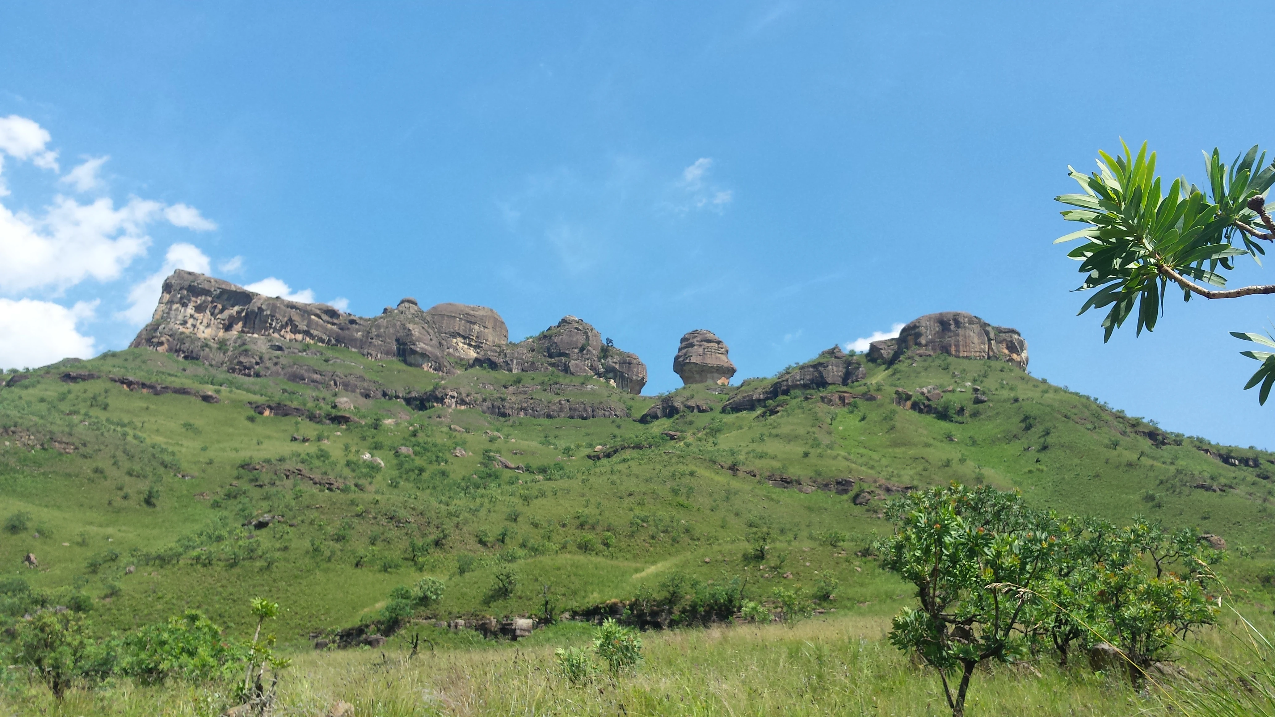
A green, grassy mountainside leading up to a rugged cliff band under a clear blue sky, with a prominent standalone rock formation known as Policeman's Helmet.
A scenic view of the Tugela Gorge area in Royal Natal National Park, featuring the distinctive Policeman's Helmet rock formation.

uKhahlamba-Drakensberg Park history and protected-area timeline

The modern uKhahlamba-Drakensberg Park emerged from the consolidation of several earlier protected initiatives across the KwaZulu-Natal portion of the Drakensberg. Royal Natal National Park, established in the early twentieth century, formed the historical core and remains one of the most visited sections of the present-day park. Over time, additional provincial reserves and wilderness areas, including Mkhomazi, Upper Mkhomazi, Mlambonja, Mdedelelo, and Mzimkhulu, were brought under coordinated protection across the escarpment.

On 21 January 1997, the area was formally listed as a Ramsar Wetland of International Importance under the official name Natal Drakensberg Park, recognizing the value of its highland wetlands and drainage systems. On 30 November 2000, the park became part of the broader Maloti-Drakensberg Park transboundary World Heritage Site after being declared by UNESCO, joining Sehlabathebe National Park in Lesotho in a unified recognition of the region's natural and cultural significance.

More recently, provincial authorities, including the KwaZulu-Natal Economic Development, Tourism, and Environmental Affairs Department, have advanced plans to expand tourism access to the park, including a proposed cable car that would open new perspectives on the escarpment. The park continues to be managed as a complex of reserves, wilderness zones, and buffer areas, with ongoing attention to balancing conservation, heritage protection, and visitor use.

uKhahlamba-Drakensberg Park landscape and geographic character

The defining feature of the park is the Drakensberg escarpment itself, the great eastern rampart of southern Africa. The landscape rises in a dramatic step from rolling KwaZulu-Natal foothills to a near-continuous wall of cliff capped by Drakensberg basalt, with the highest elevations in southern Africa reached along this edge. Where rivers such as the Tugela have cut back into the plateau, they have carved deep gorges that pierce the escarpment, producing some of the most iconic scenery in the range.

Within the Royal Natal area, the landscape is shaped by the famous amphitheater, a vast curved wall of cliff that surrounds the headwaters of the Tugela River. Below the basalt, older Clarens sandstone forms terraced slopes, hoodoos, and freestanding columns, while scree fields and boulder-strewn valleys further break up the terrain. The high grassland plateaus above the cliffs feel distinctly alpine for subtropical Africa, with wide, open vistas and seasonally harsh weather.

Away from the main escarpment edge, the park extends across secondary ridges, side valleys, and high passes such as the Sani Pass corridor, giving an unusually varied topography within a single protected area. Wilderness zones like Mkhomazi present a more eroded, badlands-style landscape of deeply gullied slopes and remote basins, contrasting with the more dramatic cliff scenery of the main escarpment edge.

uKhahlamba-Drakensberg Park ecosystems, habitats, and plant life

The park captures a striking ecological transition. Moist eastern slopes support patches of montane and mist-belt forest together with dense grassland, while the higher, drier interior supports extensive temperate highland grassland communities, typical of the Drakensberg's central plateau. This east-to-west and low-to-high gradient compresses a remarkable diversity of habitats into a relatively contained geographic area.

Wetland features are particularly important and underpin the park's Ramsar designation. Seepage zones, high-altitude marshes, and the upper reaches of major river systems create habitats of significance for waterbirds and other wetland-associated fauna. The source material notes that the Drakensberg area overall is characterized by a high level of endemism among both vertebrate and invertebrate animals, a pattern linked to the isolation of these highland habitats.

The interplay between forest, grassland, wetland, and sheer cliff creates varied microclimates and edge environments, supporting specialized plant communities and small-range animal populations. The result is a biologically rich mosaic that complements the park's geological and cultural significance, reinforcing its status as a site of exceptional natural beauty and ecological importance.

uKhahlamba-Drakensberg Park wildlife and species highlights

The park's wildlife is shaped by its predominantly high-altitude, grassland-dominated setting, with relatively low biomass of large mammals compared to lowveld reserves but a notable concentration of endemic and range-restricted species. The Drakensberg region as a whole is described in the source material as having a particularly high level of endemism among both vertebrate and invertebrate groups, reflecting the isolation and climatic distinctiveness of the highland environment.

Birds are among the park's most important wildlife assets, with UNESCO specifically highlighting the site's importance for threatened and endemic bird species alongside its plant diversity. The mix of cliff, montane grassland, forest patches, and wetland habitats supports a varied avifauna, including species closely associated with highland grasslands and the rocky edges of the escarpment.

Smaller fauna, including reptiles, amphibians, and especially invertebrates, contributes substantially to the park's ecological character. The combination of varied terrain, seasonal extremes, and habitat isolation encourages localized adaptation and a high proportion of species found nowhere else. Adjacent to the park, the Cathkin Estates Conservation and Wildlife Sanctuary extends the area available to larger game such as plains antelope, complementing the wilder escarpment zones with managed grassland habitat.

uKhahlamba-Drakensberg Park conservation status and protection priorities

The uKhahlamba-Drakensberg Park occupies a central place in the conservation of the Drakensberg escarpment. The higher South African portions of the range have largely been brought under formal protection as game reserves or wilderness areas, and the park is the most prominent expression of that approach. Within it, wilderness areas such as Mkhomazi, Upper Mkhomazi, Mlambonja, Mdedelelo, and Mzimkhulu preserve large tracts of undisturbed terrain, while the broader protected boundary buffers the escarpment against incompatible land use.

The park's designation as a Ramsar Wetland of International Importance, under the official name Natal Drakensberg Park, formally recognizes the ecological value of its highland wetlands and river systems, placing it within a global network of important wetland sites. Its inclusion as the South African component of the UNESCO-inscribed Maloti-Drakensberg Park further reinforces its conservation status, with UNESCO citing the site's exceptional natural beauty, its diversity of habitats, and its protection of endemic and threatened species.

Conserved alongside these natural values is the park's San rock-art heritage, which adds a cultural-conservation dimension. The protection of caves, rock shelters, and their paintings is integral to how the site is managed and is one of the principal reasons UNESCO inscribed the area. Adjacent conservation initiatives, including the privately managed Cathkin Estates Conservation and Wildlife Sanctuary, extend protection beyond the formal park boundary and help integrate the Drakensberg's grasslands into a broader conservation landscape.

uKhahlamba-Drakensberg Park cultural meaning and human context

The park's cultural identity is dominated by its extraordinary heritage of San parietal art. Across hundreds of caves and rock shelters, the San people of southern Africa left detailed paintings that survive in remarkable numbers and quality, making the Drakensberg the densest painted landscape in sub-Saharan Africa. Some of these artworks, according to UNESCO, may date back many tens of thousands of years, situating the park among the most significant prehistoric artistic sites on the continent.

The contemporary cultural context also reflects the broader history of the Drakensberg as a meeting zone between hunter-gatherer, pastoralist, and farming communities, and as a landscape with deep meaning to multiple groups in KwaZulu-Natal and Lesotho. The park sits in a transboundary setting where South African and Basotho heritage traditions intersect, reflected in shared recognition through the Maloti-Drakensberg Park World Heritage Site.

Management of the park today involves balancing access for visitors with the protection of both its natural systems and its rock-art sites, which are especially vulnerable to damage. The cultural weight of the San paintings, combined with the park's scenic and ecological values, is central to why the area was elevated from a national protected landscape to a component of a transnational World Heritage Site.

Top sights and standout views in uKhahlamba-Drakensberg Park

The uKhahlamba-Drakensberg Park brings together some of the most recognizable Drakensberg landscapes within a single protected area: the towering basalt-and-sandstone escarpment, the dramatic Tugela Gorge and Royal Natal amphitheater, multiple formally declared wilderness zones, and one of Africa's most important concentrations of San rock art. Its dual inscription as a UNESCO World Heritage component and a Ramsar Wetland of International Importance underlines its significance across both natural and cultural dimensions.

For visitors and observers, the park's defining qualities include the combination of sheer cliff scenery, high-altitude grassland plateaus, deep river gorges, and a wealth of caves and rock shelters, all set within a transboundary conservation framework shared with Lesotho. This blend of geology, ecology, and human heritage defines the park's identity more than any single viewpoint or species.

Best time to visit uKhahlamba-Drakensberg Park

The Drakensberg experiences a clear seasonal contrast between warm, wetter summer months and cool, drier winter months, and this shifts the character of a visit significantly. Summer brings lush green grasslands, wildflowers, and active rivers, along with afternoon thunderstorms that can affect visibility on the escarpment edge. Winter offers clearer skies, sharper mountain views, cooler hiking conditions, and reduced risk of rain, though nighttime temperatures at altitude can drop sharply.

Because the park spans a wide altitudinal range, conditions vary with elevation as well as with season. Higher-altitude areas may be inaccessible or uncomfortable during severe winter weather, while lower valleys remain mild. The source material does not provide detailed monthly access conditions, so broad seasonal patterns are the most reliable guide: lush and dramatic in the wet summer months, calm and clear in the dry winter months, with shoulder seasons often offering a balance of accessibility and scenery.
Monthly climate preview

Long-term temperature ranges and monthly precipitation averages across the park coordinate

uKhahlamba-Drakensberg Park Climate Normals and Annual Weather Patterns

Historical measurements from 1991 to 2020 record distinct seasonal shifts in average temperature and monthly precipitation across the representative elevation of uKhahlamba-Drakensberg Park. Examining the complete twelve-month climate profile reveals comprehensive statistical breakdowns for every period of the year.
Annual mean11 °C
5 °C16 °C
Jan16°
Feb15°
Mar13°
Apr10°
May
Jun
Jul
Aug
Sep11°
Oct13°
Nov14°
Dec15°
Warmest month
January

15.7 °C

Coolest month
July

4.7 °C

Wettest month
January

6.9 mm/day

Driest month
June

0.4 mm/day

Park location guide

Geography guide, regional context, and park location map for uKhahlamba-Drakensberg Park

uKhahlamba-Drakensberg Park park geography, regions, and map view in South Africa

Understand where uKhahlamba-Drakensberg Park sits in South Africa through a broader geographic reading of the surrounding landscape, nearby location context, and its mapped position within the national park landscape.

How uKhahlamba-Drakensberg Park fits into South Africa

South Africa is the southernmost country in Africa, spanning 1.22 million km² with a population of over 63 million. The country operates with three capital cities, Pretoria (executive), Cape Town (legislative), and Bloemfontein (judicial), and is renowned for its biodiversity, national parks, and multicultural society.

Wider geography shaping uKhahlamba-Drakensberg Park in South Africa

South Africa occupies the southernmost region of Africa, with coastline along both the Atlantic Ocean to the west and the Indian Ocean to the east. The interior features elevated plateaus including the Highveld, with the Drakensberg escarpment marking the eastern highlands. The country shares borders with Namibia, Botswana, Zimbabwe, Mozambique, Eswatini, and Lesotho.

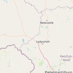
Map view of uKhahlamba-Drakensberg Park

Use this park location map to pinpoint uKhahlamba-Drakensberg Park in South Africa, understand its exact geographic position, and read its mapped placement within the surrounding landscape more clearly.

Pigeon | © OpenStreetMap contributors

Location context for uKhahlamba-Drakensberg Park

KwaZulu-Natal
Recorded earthquake history

View Historical Seismic Records and Earthquake Data for uKhahlamba-Drakensberg Park

Review the comprehensive catalogue of documented earthquakes that have occurred in the vicinity of the park. MoriAtlas provides filtered access to USGS records, allowing for the analysis of seismic events, their relative distances, and historical magnitude trends within this significant mountainous protected area.

uKhahlamba-Drakensberg Park Earthquake History

Catalogued events

2 events

Strongest magnitude

Magnitude 4.5

Most recent event

Nov 6, 2022

This history includes earthquakes recorded inside the park or within 50 km of its borders

Visual reference collection showcasing basalt escarpments, deep river gorges, and highland habitats

uKhahlamba-Drakensberg Park Landscape Photos and Mountain Scenery Imagery

Visual records capture the towering basalt walls, alpine grassland plateaus, and dramatic geological formations defining uKhahlamba-Drakensberg Park. Photographic evidence reveals the rugged protected landscape, river gorges, and ancient rock art shelters shaping the regional terrain.

A green, grassy mountainside leading up to a rugged cliff band under a clear blue sky, with a prominent standalone rock formation known as Policeman's Helmet.

A wide view from a high cliff edge looking over rolling, shadowed mountain slopes toward a distant, low-lying cloud bank under a clear blue sky.

Park atlas

Compare nearby national parks and connected highland landscapes across the region

Parks Near uKhahlamba-Drakensberg Park and Surrounding Protected Areas

Browse protected areas and regional park geography adjacent to uKhahlamba-Drakensberg Park. Compare connected mountain terrains and surrounding conservation lands across southern Africa.
A watercolor illustration featuring soft, green rolling hills in the foreground with pale, layered mountain peaks in the background, set against a plain white field.
Protected areaKwaZulu-Natal
Park boundaries overlap#1 closest

Southwest

Maloti-Drakensberg Park Geography: Mountain Escarpments and Alpine Plateau Exploration

A transboundary protected landscape spanning South Africa and Lesotho

Spanning the core of the Drakensberg mountain system, Maloti-Drakensberg Park provides a unique window into high-altitude biodiversity and geological drama. The protected area features basalt cliffs, rolling valleys, and an extensive plateau, forming a critical ecological and cultural corridor. This atlas entry covers the topographic features and spatial distribution of one of southern Africa's most significant protected landscapes.

Area
2,493.13 km²
Established
2001
Relief
Mountain
Climate
Alpine
National parkQacha's Nek District
Park boundaries overlap#2 closest

Southwest

Sehlabathebe National Park: Mapped Protected Landscape in Lesotho's Maloti Mountains

Explore high-altitude terrain, waterfalls, and ancient rock art sites.

Sehlabathebe National Park stands as a protected national park within the rugged Maloti Mountains of Lesotho's Qacha's Nek District. This destination is vital for understanding the geographic context of protected areas, featuring dramatic cliffs, iconic waterfalls like Tsoelikana, and numerous rock art sites that speak to its cultural and historical significance. Its high-altitude Afro-Alpine and sub-alpine ecosystems offer unique landscape characteristics and support notable biodiversity, making it a key point of interest for atlas-driven exploration of natural and protected terrains.

Area
69.5 km²
Established
1969
IUCN
IV
Relief
Mountain
Nature reserveKwaZulu-Natal
About 17 km away#3 closest

South

Coleford Nature Reserve: Protected Grasslands and Wetlands in KwaZulu-Natal

Tracing the landscape of a key Drakensberg foothill reserve

The Coleford Nature Reserve represents a critical protected area in the Southern Drakensberg, featuring threatened Drakensberg Foothill Moist Grassland. Its landscape is defined by the Ngwagwane River valley and diverse wetland systems, providing essential habitat for endangered bird species. This reserve functions as a gateway to the broader montane geography of the southwestern KwaZulu-Natal region.

Area
12.72 km²
Established
1948
IUCN
IV
Relief
Highland
Nature reserveKwaZulu-Natal
About 24 km away#4 closest

Southeast

Impendle Nature Reserve: Protecting Endangered Grasslands and Mistbelt Ecosystems

A highland conservation sanctuary in the KwaZulu-Natal region

Located in the mist-prone foothills of the Drakensberg, Impendle Nature Reserve stands as a critical block of surviving Midlands Mistbelt Grassland. The reserve terrain combines rugged dolerite ridges with moisture-rich seepage zones and wetlands, providing a specialized habitat for threatened bird species. This protected area remains a significant site for regional biodiversity, emphasizing scientific conservation over expansive development within the KwaZulu-Natal landscape.

Area
30.46 km²
Established
1983
IUCN
IV
Relief
Upland
Nature reserveKwaZulu-Natal
25 km away#5 closest

South

Ntsikeni Nature Reserve: High-Elevation Wetland Geography and Protected Landscape Atlas

A remote Drakensberg foothills wetland and montane grassland reserve.

Ntsikeni Nature Reserve is recognized as the largest and one of the highest wetlands in South Africa. Located in the KwaZulu-Natal province, this protected area features a unique, misty plateau landscape that sustains diverse orchid flora and essential headwater ecosystems. Use these geographic maps to examine the terrain, park boundaries, and the ecological transition between rolling foothills and the Drakensberg escarpment.

Area
92.87 km²
Established
1978
Relief
Upland
Climate
Temperate
State or regional parkKwaZulu-Natal
About 28 km away#6 closest

Northwest

Royal Natal National Park: State or Regional Park in KwaZulu-Natal's Geography

Mapped boundaries and landscape context for South African protected areas.

Royal Natal National Park serves as a vital protected landscape within the diverse geography of KwaZulu-Natal, South Africa. This state or regional park offers a focused point for atlas exploration, allowing for a detailed understanding of its mapped boundaries and regional significance. By examining Royal Natal National Park, users can gain specific insights into South Africa's network of protected natural areas and their distribution, enriching overall geographic comprehension.

Area
80.94 km²
Established
1916
Relief
Mountain
Access
Moderate access
A soft watercolor painting of a serene landscape with rolling hills in the background; a body of water in the midground; and grassy plains with a few scattered trees in the foreground.
Nature reserveKwaZulu-Natal
About 33 km away#7 closest

North

Spioenkop Dam Nature Reserve: Mapping KwaZulu-Natal Reservoir Landscapes and Heritage

Explore aquatic habitats and historic inland terrain.

Spioenkop Dam Nature Reserve serves as a focal point for protected biodiversity and historical land use in KwaZulu-Natal. The reserve spans a significant impoundment, creating a verdant aquatic habitat that contrasts with the surrounding grasslands and woodland terrain. Users can examine the park's boundaries and topographic features, including the historic Spion Kop battlefield that rises above the reservoir to anchor the northern landscape.

Area
44 km²
Established
1975
Relief
Upland
Climate
Temperate
Wildlife reserveKwaZulu-Natal
About 49 km away#8 closest

Northeast

Weenen Game Reserve: Wildlife and Restored Acacia Savanna in Inland KwaZulu-Natal

A mapped wildlife reserve and ecological restoration project

Located in the inland reaches of KwaZulu-Natal, Weenen Game Reserve represents a significant success in landscape recovery. The reserve protects a distinct mix of dry tall grassveld, dense thornveld, and valley bushveld, providing critical habitat for black and white rhinoceros, giraffe, and numerous bird species. This atlas entry details the physical terrain, drainage lines, and the engineering history that transformed the land into a functioning sanctuary.

Area
50.09 km²
Established
1975
Relief
Upland
Climate
Subtropical

Common questions about visiting, size, designation, and location context for uKhahlamba-Drakensberg Park

uKhahlamba-Drakensberg Park FAQs for park facts, access, geography, and protected area context

Find quick answers about uKhahlamba-Drakensberg Park, including protected-area facts, park geography, trail and visitor context, and how the park fits into its surrounding country and regional landscape.
MoriAtlas Explorer

Continue Your Protected Areas Search Across the Global Atlas

Deepen your exploration by continuing the structured search for national parks and protected areas worldwide. Utilize the comprehensive filtering capabilities to compare different conservation landscapes and refine your understanding of global park geography. Discover more about the distribution and characteristics of protected natural areas.

Global natural geography