Mori Atlas logo
State or regional parkRoyal Natal National Park

Discover the mapped boundaries and regional context of this state or regional park.

Royal Natal National Park: A Protected Landscape Within KwaZulu-Natal's Geography

Royal Natal National Park represents a distinct protected landscape within the broader geographic tapestry of KwaZulu-Natal, South Africa. As a state or regional park, its designated boundaries define a unique area for atlas-driven exploration, offering insights into the region's natural terrain and conservation status. Understanding Royal Natal National Park contributes to a wider appreciation of South Africa's protected natural areas and their geographical distribution, providing a foundational element for detailed map-based discovery.

Drakensberg MountainsUNESCO World Heritage SiteProvincial ParkMountain LandscapeRock FormationsWaterfalls

Royal Natal National Park

State or regional park

Park overview

Structured park overview, official facts, and landscape profile for Royal Natal National Park

Royal Natal National Park park facts, protected area profile, and essential visitor context

Review the core facts for Royal Natal National Park, including designation, size, terrain, visitor scale, habitats, and operating context in one park-focused overview.

About Royal Natal National Park

Royal Natal National Park occupies a dramatic position in the front range of the Drakensberg Mountains in KwaZulu-Natal province. Though smaller than many national parks, it contains an exceptional concentration of dramatic mountain scenery, with the centerpiece being the Amphitheatre, a massive basalt cliff that stretches roughly five kilometres and rises as much as 1,200 metres above the valley floor. This geological feature dominates the park's visual identity and serves as the backdrop for much of the recreational activity in the area. The park lies at the headwaters of the Tugela River, which flows eastward to the Indian Ocean, and the Orange River, which flows westward to the Atlantic. This watershed location gives the park particular hydrological significance for the broader southern African region. Unlike many South African protected areas, Royal Natal is a provincial park under the management of Ezemvelo KZN Wildlife, the provincial conservation authority, rather than the national SANParks organization. The park's inclusion in the Maloti-Drakensberg Transfrontier Conservation Area links it with Lesotho and creates a larger transboundary protected landscape that transcends national borders. The Drakensberg region has been inhabited by various peoples over millennia, with the San being the most recent indigenous group to occupy these mountains before colonial settlement patterns changed the area.

Quick facts and research context for Royal Natal National Park

Royal Natal National Park is a provincial park in KwaZulu-Natal, South Africa, established in September 1916 and managed by Ezemvelo KZN Wildlife. The park encompasses roughly 81 square kilometres of Drakensberg mountain terrain and forms part of a UNESCO World Heritage Site. Its defining feature is the Drakensberg Amphitheatre, a massive rock wall spanning five kilometres in length and reaching heights of 1,200 metres. The park includes Mont-Aux-Sources peak, the source of both the Orange River and the Tugela River, as well as the 948-metre Tugela Falls, one of the world's tallest waterfalls.

Protection and recognition

Analysing terrestrial protection frameworks and designated conservation status

Royal Natal National Park Protected Area Designation and Atlas Status

Researchers can verify the official terrestrial protection scope and documented designation history for Royal Natal National Park within the regional conservation network. Verified database records clarify the official management boundaries and designation framework established to safeguard the park terrain.

Protection details

Protection scope
Terrestrial
Park context

Deeper park guide and search-rich context for Royal Natal National Park

Royal Natal National Park history, landscape, wildlife, and travel context

Explore Royal Natal National Park through its history, landscape character, ecosystems, wildlife, conservation priorities, cultural context, and seasonal travel timing in a structured park guide built for atlas discovery and search intent.

Why Royal Natal National Park stands out

Royal Natal National Park is best known for the Drakensberg Amphitheatre, an enormous curved cliff face that ranks among the most spectacular rock formations in Africa. The park also contains the source points of two major southern African rivers at Mont-Aux-Sources, and protects Tugela Falls, which drops 948 metres in a dramatic vertical sequence. The distinctive "Policeman's Helmet" rock formation is another recognizable landmark and popular hiking destination within the park.

Royal Natal National Park history and protected-area timeline

Royal Natal National Park was established on 16 September 1916, making it one of the older protected areas in South Africa. Its establishment came during a period when colonial authorities and early conservationists were beginning to recognize the need to preserve distinctive natural landscapes. The park was created while South Africa was still operating under Union-era governance, and its early management would have fallen under provincial authority. The park's formation reflected growing appreciation for the Drakensberg's scenic and geological significance rather than any particular wildlife conservation imperative, as the primary attraction was always the dramatic mountain landscape rather than large mammal populations. Over the decades, the park's status within the broader conservation framework has evolved, particularly as the uKhahlamba Drakensberg region gained international recognition culminating in UNESCO World Heritage designation. The park's inclusion in the Maloti-Drakensberg Transfrontier Conservation Area represents a more recent development in its institutional history, linking South African and Lesotho conservation efforts across international boundaries.

Royal Natal National Park landscape and geographic character

The landscape of Royal Natal National Park is defined by the Drakensberg's massive basalt and sandstone formations that characterize the highland interface between the interior plateau and the coastal lowlands. The Amphitheatre is the dominant feature, a roughly five-kilometre-long curved cliff of dark basalt that rises dramatically from the surrounding terrain to heights exceeding 1,200 metres in places. This cliff forms part of the Drakensberg Escarpment, the steep eastern edge of the highland plateau. Below the Amphitheatre, the terrain descends through grassy valleys and rocky foothills cut by streams that drain toward the Tugela River system. The park includes several notable peaks, with Mont-Aux-Sources being the highest point in the immediate area. The Tugela Falls, one of the world's tallest waterfalls, drops 948 metres in a series of cascades down the escarpment face in the northeastern part of the park. The Policeman's Helmet is a distinctive pyramidal rock formation that has become one of the park's most photographed features and a popular hiking objective. The overall impression is one of spectacular mountain grandeur, with sheer cliffs, cascading water, and dramatic peaks creating a landscape of international significance.

Royal Natal National Park ecosystems, habitats, and plant life

The park's ecological character reflects its position in the Drakensberg Afro-montane environment, with vegetation patterns that vary with elevation and aspect. The lower slopes support grasslands and mixed scrub, while higher elevations feature boulder-strewn rocky terrain typical of the alpine zone. The Drakensberg region is recognized for its plant endemism, with numerous species found nowhere else on Earth. While Royal Natal is not primarily known for large mammal populations, the park supports a variety of smaller wildlife adapted to the mountain environment. The broader Drakensberg ecosystem is recognized as a global biodiversity hotspot, and while Royal Natal focuses on protecting the dramatic mountain landscape, it contributes to the conservation of this larger ecological unit. The park's inclusion in the uKhahlamba Drakensberg World Heritage Site reflects the international recognition of the region's natural significance.

Royal Natal National Park wildlife and species highlights

Royal Natal National Park is not primarily known for large mammal populations, with its reputation built on landscape and geological features rather than wildlife viewing. However, the Drakensberg environment does support various species adapted to high-altitude mountain habitats. Smaller mammals including dassies, mongooses, and various rodent species occur in the park. The birdlife includes species typical of highland grassland and cliff environments. The park's value for wildlife conservation is greatest when viewed as part of the larger uKhahlamba Drakensberg ecosystem, which provides habitat for more extensive communities of species including some that are endemic to this mountain region. The most notable wildlife connection to the park is historical rather than contemporary, as the Drakensberg was once the hunting ground of the San people, and their presence is recorded in the rock art found throughout the broader region.

Royal Natal National Park conservation status and protection priorities

Royal Natal National Park contributes to the conservation of the Drakensberg mountain environment within the provincial protected area network of KwaZulu-Natal. Its inclusion in the uKhahlamba Drakensberg Park World Heritage Site places it within one of Africa's most significant conservation designations, recognizing both the outstanding natural value and the cultural significance of the rock art heritage. The park is also part of the Maloti-Drakensberg Transfrontier Conservation Area, linking South African and Lesotho conservation efforts in a transboundary approach to mountain landscape protection. While the park is smaller than many protected areas and does not contain significant populations of large mammals, its contribution to conservation lies in protecting a critical portion of the Drakensberg's most dramatic scenery and the watershed areas that feed major river systems.

Royal Natal National Park cultural meaning and human context

The Drakensberg Mountains hold deep cultural significance for the indigenous peoples of southern Africa. The San people, also historically referred to as bushmen, were the last indigenous inhabitants of these mountains, using the area as hunting grounds before being displaced by later migrations and colonial expansion. Though the San no longer live in the area, they left an extraordinary cultural legacy in the form of rock paintings, which are found throughout the Drakensberg region and represent some of the most significant rock art traditions in Africa. Royal Natal National Park sits within this cultural landscape, and while the specific rock art sites may not be within the park boundaries, the park's inclusion in the broader uKhahlamba Drakensberg World Heritage Site recognizes the inseparable connection between the natural landscape and the cultural heritage of the San people.

Top sights and standout views in Royal Natal National Park

The Drakensberg Amphitheatre stands as the park's most spectacular feature, a massive curved cliff face visible from many parts of the park and forming the backdrop for memorable hiking experiences. The Policeman's Helmet provides a distinctive pyramidal landmark that has become emblematic of Royal Natal. Mont-Aux-Sources peak holds particular significance as the hydrographic source of both the Orange River and the Tugela River, two of southern Africa's major river systems. The Tugela Falls, dropping 948 metres down the escarpment, ranks among the world's tallest waterfalls. The park offers access to some of the most scenic mountain trails in the Drakensberg, with routes that approach the base of the Amphitheatre and climb toward the high peaks.

Best time to visit Royal Natal National Park

The Drakensberg mountain environment can be visited throughout the year, though each season offers a different character. The summer months from November to March bring warmer temperatures and the lush green growth that gives the mountains their most verdant appearance, though afternoon thunderstorms are common. Winter from May to September often brings snow to the high peaks above the park, creating dramatic winter scenery but also colder conditions at night. The shoulder seasons of spring and autumn can offer a balance of comfortable temperatures and more stable weather patterns. Visitors planning backcountry hiking should be aware that conditions can change rapidly in the mountain environment, and the park's high elevation means that weather can be significantly different from the lowland areas below.
Monthly climate preview

Long-term precipitation and temperature rhythms mapped at high elevation

Climate Profile and Monthly Weather Normals for Royal Natal National Park

Climatological data from a representative mountain coordinate of 2050 meters reveals a pattern of warm, wet periods contrasted with freezing, dry intervals. Exploring the complete twelve-month profile provides a detailed breakdown of average temperature ranges and precipitation rhythms to assist in geographic analysis.
Annual mean12 °C
5 °C18 °C
Jan18°
Feb17°
Mar15°
Apr12°
May
Jun
Jul
Aug
Sep12°
Oct14°
Nov16°
Dec17°
Warmest month
January

17.6 °C

Coolest month
July

5.4 °C

Wettest month
January

5.1 mm/day

Driest month
July

0.4 mm/day

Park location guide

Geography guide, regional context, and park location map for Royal Natal National Park

Royal Natal National Park park geography, regions, and map view in South Africa

Understand where Royal Natal National Park sits in South Africa through a broader geographic reading of the surrounding landscape, nearby location context, and its mapped position within the national park landscape.

How Royal Natal National Park fits into South Africa

South Africa is the southernmost country in Africa, spanning 1.22 million km² with a population of over 63 million. The country operates with three capital cities, Pretoria (executive), Cape Town (legislative), and Bloemfontein (judicial), and is renowned for its biodiversity, national parks, and multicultural society.

Wider geography shaping Royal Natal National Park in South Africa

South Africa occupies the southernmost region of Africa, with coastline along both the Atlantic Ocean to the west and the Indian Ocean to the east. The interior features elevated plateaus including the Highveld, with the Drakensberg escarpment marking the eastern highlands. The country shares borders with Namibia, Botswana, Zimbabwe, Mozambique, Eswatini, and Lesotho.

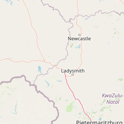
Map view of Royal Natal National Park

Use this park location map to pinpoint Royal Natal National Park in South Africa, understand its exact geographic position, and read its mapped placement within the surrounding landscape more clearly.

Pigeon | © OpenStreetMap contributors

Location context for Royal Natal National Park

KwaZulu-Natal
Park atlas

Explore more of the uKhahlamba Drakensberg ecosystem and compare mountain parks within South Africa's KwaZulu-Natal province.

Discover Other Protected Areas Near Royal Natal National Park in the Drakensberg Mountains

After exploring Royal Natal National Park's dramatic Drakensberg Amphitheatre, browse nearby protected areas and compare their unique mountain landscapes across South Africa's KwaZulu-Natal region. Expand your geographic understanding of the transboundary Maloti-Drakensberg Transfrontier Conservation Area and trace the spread of conservation efforts in this significant highland ecosystem.
Protected areaKwaZulu-Natal
Mapped location lies within the park boundary#1 closest

South

Maloti-Drakensberg Park Geography: Mountain Escarpments and Alpine Plateau Exploration

A transboundary protected landscape spanning South Africa and Lesotho

Spanning the core of the Drakensberg mountain system, Maloti-Drakensberg Park provides a unique window into high-altitude biodiversity and geological drama. The protected area features basalt cliffs, rolling valleys, and an extensive plateau, forming a critical ecological and cultural corridor. This atlas entry covers the topographic features and spatial distribution of one of southern Africa's most significant protected landscapes.

Area
2,493.13 km²
Established
2001
Relief
Mountain
Climate
Alpine
National parkFree State
About 24 km away#2 closest

Northwest

Golden Gate Highlands National Park: Protected Area Atlas & Geographic Exploration

Mapping the natural terrain and boundaries of this national park.

Understand the geographic scope and protected landscape of Golden Gate Highlands National Park. This detail page provides an atlas-informed perspective on its natural terrain, mapped boundaries, and regional context within South Africa's Free State. It serves as a foundational entry point for exploring the park's specific geography and protected-area status.

Area
340 km²
Established
1963
Relief
Mountain
Climate
Temperate
Protected areaKwaZulu-Natal
About 28 km away#3 closest

Southeast

uKhahlamba-Drakensberg Park: Protected Mountain Landscapes and Escarpment Geography in South Africa

Exploring the basalt cliffs and alpine plateau of KwaZulu-Natal.

uKhahlamba-Drakensberg Park encompasses an expansive protected region where the Drakensberg escarpment rises sharply from the foothills of KwaZulu-Natal. This atlas record details the park landscape, including its transition from sandstone terraces to high-altitude basalt, its extensive river gorges, and the concentration of archaeological cave sites. Use this resource to understand the geographic scale of this transboundary conservation area.

Area
2,429.13 km²
Relief
Mountain
Climate
Temperate
Access
Access unknown
Nature reserveKwaZulu-Natal
About 56 km away#4 closest

East

Spioenkop Dam Nature Reserve: Mapping KwaZulu-Natal Reservoir Landscapes and Heritage

Explore aquatic habitats and historic inland terrain.

Spioenkop Dam Nature Reserve serves as a focal point for protected biodiversity and historical land use in KwaZulu-Natal. The reserve spans a significant impoundment, creating a verdant aquatic habitat that contrasts with the surrounding grasslands and woodland terrain. Users can examine the park's boundaries and topographic features, including the historic Spion Kop battlefield that rises above the reservoir to anchor the northern landscape.

Area
44 km²
Established
1975
Relief
Upland
Climate
Temperate
National parkLeribe District
About 62 km away#5 closest

Southwest

Ts'ehlanyane National Park: Indigenous Forest & Maloti Mountain Protected Landscape

Explore unique terrain and endemic plant habitats.

Ts'ehlanyane National Park is a vital protected area in Lesotho's Leribe District, distinguished by its rare indigenous forest and the prevalence of berg bamboo. This national park offers insight into unique altitudinal landscapes and botanically significant ecosystems, situated within the expansive Maloti Mountains. Its protected status makes it a key destination for understanding the regional geography and the conservation of specialized natural habitats.

IUCN
II
Relief
Mountain
Climate
Temperate
Access
Moderate access
Wildlife reserveKwaZulu-Natal
About 104 km away#6 closest

East

Weenen Game Reserve: Wildlife and Restored Acacia Savanna in Inland KwaZulu-Natal

A mapped wildlife reserve and ecological restoration project

Located in the inland reaches of KwaZulu-Natal, Weenen Game Reserve represents a significant success in landscape recovery. The reserve protects a distinct mix of dry tall grassveld, dense thornveld, and valley bushveld, providing critical habitat for black and white rhinoceros, giraffe, and numerous bird species. This atlas entry details the physical terrain, drainage lines, and the engineering history that transformed the land into a functioning sanctuary.

Area
50.09 km²
Established
1975
Relief
Upland
Climate
Subtropical
National parkQacha's Nek District
About 129 km away#7 closest

South

Sehlabathebe National Park: Mapped Protected Landscape in Lesotho's Maloti Mountains

Explore high-altitude terrain, waterfalls, and ancient rock art sites.

Sehlabathebe National Park stands as a protected national park within the rugged Maloti Mountains of Lesotho's Qacha's Nek District. This destination is vital for understanding the geographic context of protected areas, featuring dramatic cliffs, iconic waterfalls like Tsoelikana, and numerous rock art sites that speak to its cultural and historical significance. Its high-altitude Afro-Alpine and sub-alpine ecosystems offer unique landscape characteristics and support notable biodiversity, making it a key point of interest for atlas-driven exploration of natural and protected terrains.

Area
69.5 km²
Established
1969
IUCN
IV
Relief
Mountain
Nature reserveKwaZulu-Natal
About 140 km away#8 closest

Southeast

Impendle Nature Reserve: Protecting Endangered Grasslands and Mistbelt Ecosystems

A highland conservation sanctuary in the KwaZulu-Natal region

Located in the mist-prone foothills of the Drakensberg, Impendle Nature Reserve stands as a critical block of surviving Midlands Mistbelt Grassland. The reserve terrain combines rugged dolerite ridges with moisture-rich seepage zones and wetlands, providing a specialized habitat for threatened bird species. This protected area remains a significant site for regional biodiversity, emphasizing scientific conservation over expansive development within the KwaZulu-Natal landscape.

Area
30.46 km²
Established
1983
IUCN
IV
Relief
Upland

Common questions about visiting, size, designation, and location context for Royal Natal National Park

Royal Natal National Park FAQs for park facts, access, geography, and protected area context

Find quick answers about Royal Natal National Park, including protected-area facts, park geography, trail and visitor context, and how the park fits into its surrounding country and regional landscape.
MoriAtlas Explorer

Continue Your Protected Areas Search Across the Global Atlas

Deepen your exploration by continuing the structured search for national parks and protected areas worldwide. Utilize the comprehensive filtering capabilities to compare different conservation landscapes and refine your understanding of global park geography. Discover more about the distribution and characteristics of protected natural areas.

Global natural geography