
Mori Atlas logo
Nature reserveWooldse Veen

Explore the geography of this restored Dutch raised bog and its connected borderland ecosystem.

Wooldse Veen Nature Reserve: An Atlas of Transboundary Peatland and Bog Landscapes in the Netherlands

Wooldse Veen is a distinctive peatland nature reserve located in the eastern Dutch province of Gelderland. This protected area showcases an actively regenerating raised bog, forming a transboundary habitat that extends across the border into Germany. The landscape is characterized by a network of peat pools and ridges shaped by historic land use, now restored to support sphagnum mosses, birch woodland, and diverse wetland species within the wider Winterswijk National Landscape.

raised bogpeatlandNatura 2000 sitetransboundary reserveWinterswijkGelderland
A flat vector-style illustration showing a valley with high mountain cliffs, a winding river, evergreen forests, and a distant waterfall under a stylized sun.

Wooldse Veen

Nature reserve

Park overview

Structured park overview, official facts, and landscape profile for Wooldse Veen

Wooldse Veen park facts, protected area profile, and essential visitor context

Review the core facts for Wooldse Veen, including designation, size, terrain, visitor scale, habitats, and operating context in one park-focused overview.

About Wooldse Veen

Wooldse Veen is a peatland nature reserve in the eastern Netherlands, set on the southeastern outskirts of Winterswijk close to the German border. Although the protected Dutch area covers only about fifty hectares, it is the smaller half of a much larger peat complex that runs uninterrupted into the German Burlo-Vardingholter Venn und Entenschlatt reserve. In Dutch nature management the site is treated as one ecological unit with its German neighbour, and the combined bog is protected as a Natura 2000 area under the European Habitats Directive.

The bog itself is what defines the reserve. Centuries of turf cutting left the surface scored with peat pools and the spoil banks, the veendijken, that once separated them. After cutting ended, parts of the bog dried out, but a programme of rewetting has encouraged new peat-forming vegetation to return. In the rewetted diggings, sphagnum mosses and characteristic bog plants such as sundew, bog rosemary, and small cranberry are spreading, while the old banks carry birch woodland, sometimes mixed with oak. The flat, open, waterlogged character of the landscape, with pools, low banks of trees, and surrounding heath, is the visual signature of the site.

Culturally, the reserve sits on a long-disputed frontier. A historic smugglers' patrol path, the commiezenpad, runs through the peat along the line of the Dutch-German state border, and around 186 old boundary stones still mark the boundary through the bog. Today this route forms part of cross-border walking and cycling networks that connect Wooldse Veen with other parts of the Winterswijk area. Because it is a designated Natura 2000 site, the reserve is also well integrated into the wider framework of protected areas in the Achterhoek and the Winterswijk National Landscape.

Quick facts and research context for Wooldse Veen

Wooldse Veen is a Dutch peatland nature reserve of about fifty hectares in Gelderland, run in partnership with the conservation group Natuurmonumenten. It lies on the southeastern edge of the municipality of Winterswijk and is treated as a single habitat with the larger German Burlo-Vardingholter Venn und Entenschlatt reserve across the border in Kreis Borken. The peatland has been owned and managed in part by Natuurmonumenten since 1949 and is a designated site under the European Natura 2000 network.

Protection and recognition

Documented terrestrial protection scope, transboundary status, and Natura 2000 records.

Wooldse Veen Protection Status and International Recognition Data

Terrestrial protection metrics for Wooldse Veen outline established conservation boundaries and cross border oversight. Official Natura 2000 designations establish verified international recognition standards for regional landscape management.

International recognition

Protection details

Protection scope
Terrestrial
Transboundary protection
Yes
Park context

Deeper park guide and search-rich context for Wooldse Veen

Wooldse Veen history, landscape, wildlife, and travel context

Explore Wooldse Veen through its history, landscape character, ecosystems, wildlife, conservation priorities, cultural context, and seasonal travel timing in a structured park guide built for atlas discovery and search intent.

Why Wooldse Veen stands out

Wooldse Veen is best known as a transboundary raised bog, the small Dutch piece of a peat complex that continues across the border into Germany. Old peat diggings and their remaining walls shape the visible landscape, and the reserve is notable for the active restoration of wet bog conditions that allow new sphagnum-dominated peatland, with sundews, bog rosemary, and cranberry, to grow back in the former diggings.
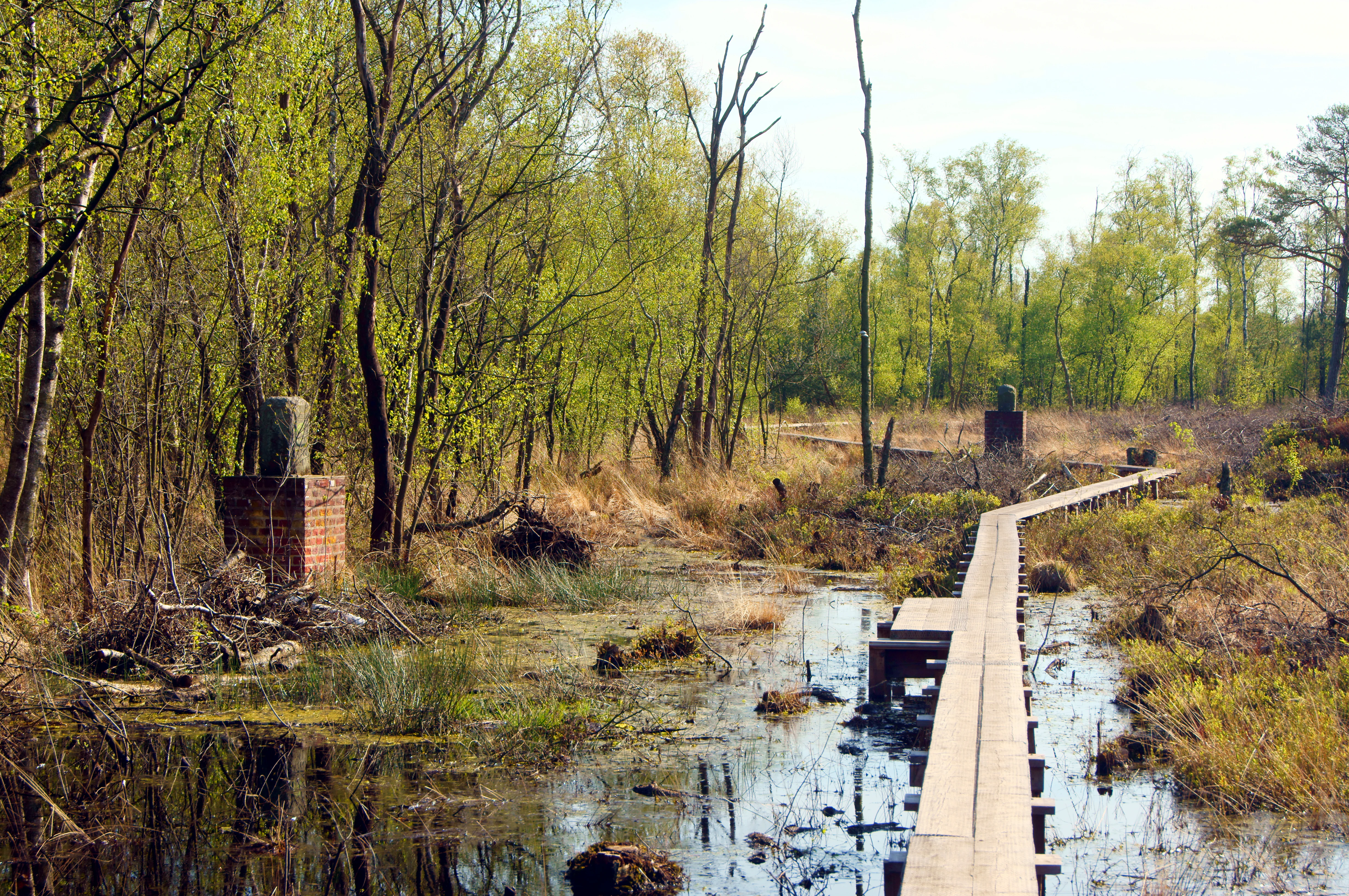
A narrow wooden boardwalk stretches through a marshy bog area, flanked by trees and low-lying vegetation, with historical brick boundary markers visible along the path.
A wooden boardwalk winding through the boglands of Wooldse Veen, passing by historical boundary markers.

Wooldse Veen history and protected-area timeline

Around 1949 the area that now forms Wooldse Veen came partially into the ownership and active management of the Dutch conservation organisation Natuurmonumenten, along with several private owners. From that point on the land was treated as a protected nature reserve rather than an extractable peat resource, even though the surface still bore the visible traces of earlier turf cutting.

In 2005 the Dutch government designated a much wider area, the Nationaal Landschap Winterswijk, as a national landscape of almost 22,000 hectares. Wooldse Veen was included as one of twenty component areas within that designation, alongside neighbours such as the Korenburgerveen, Bekendelle, and Willinks Weust. This elevated the small reserve's status from a local Natuurmonumenten site to part of a nationally recognised landscape.

Both the Dutch and the German halves of the peat complex are now formally protected under the European Habitats Directive as a single Natura 2000 site, and Dutch and German nature organisations cooperate on restoration. The work is described as having good prospects, helped by an underlying layer of boulder clay that limits how deeply the bog can dry out.

Wooldse Veen landscape and geographic character

Wooldse Veen is a flat, waterlogged peatland landscape in a relatively quiet corner of the Achterhoek, in eastern Gelderland. Its surface is shaped by centuries of small-scale turf cutting: a network of narrow peat pools forms the lowest parts of the reserve, separated by slightly higher peat walls that rise above the pools as low, linear ridges. The pools hold the rainwater that sustains the bog, while the walls and shallower edges support denser vegetation, including birch woodland with occasional oak.

Beyond the immediate peat, the landscape reads as classic eastern Dutch moorland country. Surrounding heath and farmland give the bog a wide, open outlook, and the gently sloping terrain of the Achterhoek reaches up toward the small hills and wooded edges of the Winterswijk area. Together with neighbouring areas such as the Korenburgerveen, Wooldse Veen forms a connected mosaic of bog, heath, woodland, and small-scale agricultural land, characteristic of the Winterswijk National Landscape.

Wooldse Veen ecosystems, habitats, and plant life

Despite its small size, Wooldse Veen packs a recognisably raised-bog ecosystem. The peat pools and saturated edges of the bog are dominated by sphagnum mosses, and as the restoration programme has rewetted former diggings, classic bog plants have begun to recolonise. Sundews, the small insectivorous plants of wet peat, grow alongside bog rosemary, small cranberry, and other dwarf shrubs typical of northwestern European raised bogs. Together these species indicate that peat-forming conditions are once again establishing in the reserve.

The peat walls that separate the pools carry a different community. Here, taller vegetation has established itself after the end of cutting, and birch woodland, sometimes enriched with oak, now covers the slightly higher, drier strips. The result is a fine-grained mosaic of open water, soft bog vegetation, heath-like patches on the walls, and patches of low woodland, all within a compact area. This mosaic is the structural reason the site can support such a wide range of wildlife for its size.

Wooldse Veen wildlife and species highlights

Wooldse Veen supports a notably diverse fauna for a small reserve because of this structural variety. The bog pools and saturated peat are inhabited by amphibians such as the great crested newt, and the wet heath edges are home to reptiles including the slow worm and the smooth snake. The old peat walls and surrounding rough vegetation provide cover for badgers, which have setts in and around the bog, while birds of prey, including common buzzards, hunt over the open peatland.

The reserve is perhaps most noted among naturalists for its invertebrates. Dragonflies and damselflies are particularly rich in the peat pools, with species such as the black darter and the emperor dragonfly recorded in the area. Butterflies also thrive along the warm, sheltered edges of the bog, where bog and heath species share habitat. Together with badgers, smooth snakes, and a wide range of dragonflies, this mix of species makes the reserve an unexpectedly rich peatland refuge.

Wooldse Veen conservation status and protection priorities

The principal value of Wooldse Veen for conservation lies in the recovery of actively peat-forming vegetation on a site whose bog surface was once broken up by turf cutting. Restoration work by Natuurmonumenten, carried out in cooperation with German conservation groups across the border, aims at rewetting former diggings so that sphagnum and accompanying bog plants can re-establish and lock carbon back into peat.

Underlying boulder clay in the subsoil has helped prevent the bog from drying out too deeply, and this gives the restoration a realistic chance of long-term success. The reserve's formal recognition as a Natura 2000 site under the European Habitats Directive, and as a component of the Winterswijk National Landscape, gives both the Dutch and German halves of the peat complex long-term protection. Together, these designations mean the bog is treated as a single transboundary conservation priority.

Wooldse Veen cultural meaning and human context

Wooldse Veen sits on a section of the Dutch-German border that has been shaped by centuries of cross-border trade and the attempts to control it. The reserve's most distinctive cultural feature is the commiezenpad, a historic smugglers' patrol path that runs through the peat directly along the state line. This path was used by customs officers, commiezen, to catch smugglers moving goods across the bog.

A striking physical reminder of the border's age is the presence of around 186 old boundary stones along the route through the peat, a remarkable concentration for such a short stretch of frontier. Today the old patrol path has become part of cross-border walking and cycling routes, including those using so-called green border crossings that link walks, rides, and nature experiences on either side of the border. In this way, Wooldse Veen carries not only ecological value but also a tangible cultural memory of the contested edge of the Netherlands.

Top sights and standout views in Wooldse Veen

Wooldse Veen offers a compact but distinctive transboundary raised bog, where active peat restoration has brought sphagnum mosses, sundews, bog rosemary, and small cranberry back into former diggings. The reserve sits within the wider Winterswijk National Landscape and is formally protected as part of a Natura 2000 site that runs across the German border into the Burlo-Vardingholter Venn und Entenschlatt.

Its most memorable features are visibly layered: the peat pools and birch-covered peat walls as a wetland landscape, the historic commiezenpad that runs through the bog along the border, the unusual concentration of 186 old boundary stones, and the rich but small-scale wildlife of dragonflies, amphibians, reptiles, badgers, and buzzards that thrives in this mosaic of bog, heath, and low woodland.

Best time to visit Wooldse Veen

Because Wooldse Veen is a small peatland reserve whose visual character depends strongly on moisture and temperature, late spring and early summer are typically the most rewarding period. Sphagnum, sundews, and other bog vegetation are at their most active as the pools fill with rainwater and the surrounding heath greens up, while dragonflies and butterflies are most visible along the warmer edges of the bog.

In summer the open water of the peat pools and the dragonfly activity are at their peak, and the heathy surroundings take on warm colours. In autumn and winter the bog takes on a quieter character, with peat pools holding still water and the birch woodland on the old peat walls standing out in bare relief against the open mossy flats, conditions that can make the patterns of turf cutting easiest to read in the landscape. Peatland paths can be wet, soft, and physically demanding underfoot at any time of year.


Monthly climate preview

Long-term representative point measurements tracking monthly thermal ranges and precipitation patterns at Wooldse Veen

Wooldse Veen Climate Normals, Annual Temperature and Precipitation Rhythm

Wooldse Veen records a measured annual temperature and precipitation rhythm across representative coordinates spanning from sub-zero winter minimums to warm summer maximums. Examining the full twelve-month climate profile reveals detailed monthly averages that clarify long-term meteorological normals without relying on short-term forecasts.
Annual mean10 °C
2 °C18 °C
Jan
Feb
Mar
Apr
May13°
Jun16°
Jul18°
Aug18°
Sep15°
Oct10°
Nov
Dec
Warmest month
July

18.4 °C

Coolest month
January

1.6 °C

Wettest month
December

2.5 mm/day

Driest month
April

1.5 mm/day

Park location guide

Geography guide, regional context, and park location map for Wooldse Veen

Wooldse Veen park geography, regions, and map view in Netherlands

Understand where Wooldse Veen sits in Netherlands through a broader geographic reading of the surrounding landscape, nearby location context, and its mapped position within the national park landscape.

How Wooldse Veen fits into Netherlands

The Netherlands is a low-lying coastal country in Northwestern Europe, famous for its extensive dike and canal systems that reclaim land from the sea. It consists of twelve provinces and is known for tulips, windmills, and cycling culture. The country is a founding member of the European Union with Amsterdam as its capital and The Hague as the seat of government.

Wider geography shaping Wooldse Veen in Netherlands

The Netherlands is located in Northwestern Europe along the North Sea coastline to the north and west. It borders Germany to the east and Belgium to the south. The country is notably flat, with a significant portion of its territory lying below sea level, protected by dikes and dune systems. It consists of twelve provinces and also includes overseas municipalities in the Caribbean.

Map view of Wooldse Veen

Use this park location map to pinpoint Wooldse Veen in Netherlands, understand its exact geographic position, and read its mapped placement within the surrounding landscape more clearly.

Pigeon | © OpenStreetMap contributors
Recorded earthquake history

Explore the Historical Earthquake Records Associated with Wooldse Veen

Examine the seismic history of the terrain surrounding Wooldse Veen through a structured catalogue of recorded earthquake events. This MoriAtlas resource tracks regional seismic data to provide a clearer understanding of the landscape history in this part of Gelderland.

Wooldse Veen Earthquake History

Catalogued events

53 events

Strongest magnitude

Magnitude 4.3

Most recent event

Jul 24, 2009

This history includes earthquakes recorded inside the park or within 50 km of its borders

Explore protected area imagery highlighting peat pools, birch woodland, and wetland terrain.

Wooldse Veen Landscape Photos and Scenery: Visualizing the Transboundary Raised Bog

Visual documentation captures the unique waterlogged terrain and regenerating raised bog habitats of Wooldse Veen across the Dutch and German border. Detailed photographic records reveal the complex wetland scenery, peat walls, and protected moorland character of the reserve.

A narrow wooden boardwalk stretches through a marshy bog area, flanked by trees and low-lying vegetation, with historical brick boundary markers visible along the path.

A low-angle view of a frost-covered heath and bog landscape with small pine trees and dry grasses under a cloudy sky.

Park atlas

Compare surrounding moorland reserves and connected transboundary wetland ecosystems

Parks Near Wooldse Veen: Exploring Adjacent Protected Areas and Regional Wetlands

Browse nearby national parks and protected areas sharing the distinctive peatland geography of the eastern Dutch border. Expanding the scope beyond Wooldse Veen reveals a broader network of regional wetland reserves, lowland heath, and conserved habitats.
Nature reserveGelderland
About 10 km away#1 closest

Northwest

Korenburgerveen Nature Reserve: Geography and Protected Peatland Landscapes in Gelderland

A vital wetland and raised bog complex in the Dutch Achterhoek

Korenburgerveen represents a key protected peatland basin in Gelderland, featuring a diverse mosaic of marsh woodland, blue grassland, and active raised bog. Use this geographic entry to analyze the reserve's position within the wider Nationaal Landschap Winterswijk and observe the hydrological restoration of its rare wetland terrain.

Relief
Lowland
Climate
Temperate
Scope
Terrestrial
Water
Major water bodies
Nature reserveNordrhein-Westfalen
About 18 km away#2 closest

North

Moore und Heiden des westlichen Münsterlandes Nature Reserve: Regional Protected Landscapes

Bog and heathland geography in western North Rhine-Westphalia

The Moore und Heiden des westlichen Münsterlandes nature reserve is a vital complex of peatlands, wet meadows, and bog woodlands situated in western Germany. This site offers a unique geographic study of restored hydrology and open moorland, providing critical habitats for rare waders and the northernmost breeding colony of Greater Flamingo in Europe.

Area
23 km²
Established
1983
A soft, light watercolor painting of a serene marshy landscape with green hills, lush vegetation, and pink flowers in the foreground.
Nature reserveNordrhein-Westfalen
About 18 km away#3 closest

North

Krosewicker Grenzwald Nature Reserve: Protected Woodland and Border Geography Atlas

Münsterland nature reserve with cross-border habitat significance

Krosewicker Grenzwald is a rare island of woodland set within the intensely cultivated agricultural plains of the western Münsterland. This nature reserve, straddling the German-Dutch border, supports specialized birch and pipegrass communities while functioning as a critical component of the broader Natura 2000 conservation framework.

Area
0.074 km²
Established
1985
IUCN
IV
Watercolor painting of a tranquil pond at Kranenmeer, showing reflective water, distant tree lines, and foreground foliage hanging from the upper right corner.
Nature reserveNordrhein-Westfalen
19 km away#4 closest

Southeast

Kranenmeer Nature Reserve: Mapped Geography and Protected Wetland Boundaries

A preserved moorland enclave in the Westmünsterland region.

Kranenmeer preserves a fragile mosaic of open water, bog vegetation, and alder carr woodland in a compact site within Nordrhein-Westfalen. Study the mapped protected boundaries and subtle terrain transitions of this significant nature reserve that serves as a vital habitat for rare amphibians and specialized wetland species in the lowland northwest of Germany.

Area
1.4 km²
Established
1950
Relief
Lowland
Climate
Temperate
A watercolor painting showing a soft, pastoral landscape with green rolling hills, distant pinkish-hued mountains, and small clusters of trees.
Nature reserveNordrhein-Westfalen
About 22 km away#5 closest

East

Kuhlenvenn Nature Reserve: Geographic Insights and Wetland Protection in Germany

A vital bird refuge within the Münsterland landscape

Kuhlenvenn is a 67 hectare nature reserve situated in the western Münsterland. Originally formed through industrial sand extraction, this area now features a rich habitat mosaic of meadows, wet grasslands, and shallow pools. It serves as a key regional center for migratory and breeding bird species, demonstrating how restored landscapes provide essential refuge in the broader North Rhine-Westphalia geography.

Area
0.67 km²
Established
1988
IUCN
IV
Relief
Lowland
Nature reserveNorth Rhine-Westphalia
22 km away#6 closest

South

Lichtenhagen Nature Reserve: Protected Lowland Landscapes and Habitat Geography in Wesel

A critical habitat mosaic for regional reptile and amphibian populations.

Lichtenhagen constitutes a distinct protected site within the Lower Rhine region, showcasing a unique ecological transition between heathland, still-water basins, and oak-dominated woodland. This former industrial site provides a protected refuge for the common European adder, smooth snake, and grass snake, representing a crucial case study in landscape restoration and regional conservation within North Rhine-Westphalia.

Area
1.1 km²
Established
1981
IUCN
IV
Watercolor painting of a low-lying, marshy landscape with soft green meadows and sparse vegetation against a white background.
Nature reserveNorth Rhine-Westphalia
About 23 km away#7 closest

North

Lüntener Fischteiche Nature Reserve: Geography and Protected Area Landscape Map

A preserved mosaic of Münsterland heath and bog ecosystems

Lüntener Fischteiche is a specialized nature reserve in North Rhine-Westphalia, documented here for its distinct heath-pond character and ecological significance within the German-Dutch borderland. The site preserves remnants of bog and heath vegetation embedded within a pine forest matrix, serving as an important hub for regional waterbird populations and transboundary habitat connectivity.

Area
1.011 km²
Established
1959
IUCN
IV
Nature reserveNorth Rhine-Westphalia
24 km away#8 closest

Southwest

Unterer Niederrhein Nature Reserve: Geographic Atlas and Floodplain Landscape Mapping

Riverine wetland ecosystems in North Rhine-Westphalia

Uncover the protected landscape of Unterer Niederrhein, an expansive bird protection area along the German Lower Rhine. The region features a mosaic of sand banks, oxbow lakes, and seasonally flooded grasslands, creating a highly interconnected riverine ecosystem that spans across the districts of Kleve and Wesel.

Area
258.094 km²
Established
1983
Relief
Lowland
Climate
Temperate

Common questions about visiting, size, designation, and location context for Wooldse Veen

Wooldse Veen FAQs for park facts, access, geography, and protected area context

Find quick answers about Wooldse Veen, including protected-area facts, park geography, trail and visitor context, and how the park fits into its surrounding country and regional landscape.
MoriAtlas Explorer

Continue Your Protected Areas Search Across the Global Atlas

Deepen your exploration by continuing the structured search for national parks and protected areas worldwide. Utilize the comprehensive filtering capabilities to compare different conservation landscapes and refine your understanding of global park geography. Discover more about the distribution and characteristics of protected natural areas.

Global natural geography