


Mori Atlas logo
Protected landscapeWrzelowiecki Park Krajobrazowy

Tracing the geological ridges, Vistula slopes, and loess terrain of this Polish protected area

Wrzelowiecki Park Krajobrazowy: A Mapped Protected Landscape in the Lubelskie Voivodeship Upland

Wrzelowiecki Park Krajobrazowy stands as a significant protected landscape within the Wzniesienia Urzędowskie hills of the Lubelskie Voivodeship. This geographic study focuses on its distinctive loess gorges, steep river-bank escarpments, and a diverse mosaic of hornbeam-oak forests. The area serves as a primary example of upland regional geography where ancient Cretaceous geological layers meet fertile agricultural soils.

landscape parkloess gorgesupland hillsVistula valleymixed deciduous foresthornbearn-oak woodland
A flat-style digital illustration showing a winding river flowing through a forested valley with a waterfall in the distance, framed by stylized trees and mountains.

Wrzelowiecki Park Krajobrazowy

Protected landscape

Park overview

Structured park overview, official facts, and landscape profile for Wrzelowiecki Park Krajobrazowy

Wrzelowiecki Park Krajobrazowy park facts, protected area profile, and essential visitor context

Review the core facts for Wrzelowiecki Park Krajobrazowy, including designation, size, terrain, visitor scale, habitats, and operating context in one park-focused overview.

About Wrzelowiecki Park Krajobrazowy

Wrzelowiecki Park Krajobrazowy sits in the northern and western part of the Wzniesienia Urzędowskie, a gently undulating range that forms the right-bank backdrop of the Vistula in the Lublin region. The park was established in 1990 to safeguard the relief, natural habitats, and cultural landscape of this stretch of upland, and it remains one of the more distinctive protected landscape areas in eastern Poland, balancing ecological value with a layered human heritage.

Geologically, the park lies along a transitional zone between the Vistula river valley and the inland loess-covered upland. Along the right slope of the Vistula, exposed Cretaceous rocks carry notable marine fossils, including sponges, bivalves, corals, and ammonites. Further into the hills, deeper loess deposits have shaped narrow ravines and gullies, including the well-known loess gorge at Kluczkowice-Osiedle. The combination of fossil-bearing chalk exposures and loess relief creates an unusually varied geological reading for a relatively small area.

Ecologically, more than a third of the park's surface is under forest, dominated by hornbeam-oak and pine-oak communities. These woodlands harbor protected and regionally rare plants such as the Martagon lily, the Moldavian monkshood, and the interrupted clubmoss. Mammals typical of Central European mixed forests are present, including the hazel dormouse, European badger, and martens. Around the village of Kaliszany, the Kaliszańskie Islands form a recognized refuge for waterfowl and wetland birds, adding a different ecological dimension to the predominantly upland character of the park.

The soils of the park are predominantly fertile brown soils, which have supported long-established orchards and fruit-growing traditions across the hills. This agricultural backdrop is recognized as part of the cultural landscape value of the protected area. Several historic settlements within the park contribute notable architecture, including a 19th-century palace in Kluczkowice designed by the architect Stanisław Witkiewicz, a Baroque post-Bernardine complex at Józefów nad Wisłą founded by Józef Potocki, Gothic and Renaissance-style churches, manor houses, and monuments tied to the January Uprising of 1863. Together, these elements give Wrzelowiecki Park its identity as both a natural and a cultural landscape.

Quick facts and research context for Wrzelowiecki Park Krajobrazowy

Wrzelowiecki Park Krajobrazowy is a Polish landscape park, a category of protected area focused on preserving scenic and culturally significant countryside. It lies in the Lubelskie Voivodeship and administratively spans the gminas of Łaziska, Opole Lubelskie, and Józefów nad Wisłą. The protected area forms part of the Wzniesienia Urzędowskie mesoregion, within the broader right-bank Vistula upland belt.

The park was created in 1990 through a resolution of the provincial council in Lublin. Its core area covers just under 50 square kilometers, with a surrounding buffer zone of around 136 square kilometers. Forest dominated by hornbeam-oak and pine-oak communities occupies more than a third of the park, while exposed Cretaceous rocks along the Vistula escarpment and deeper loess soils elsewhere support a productive agricultural tradition, especially orchards, alongside the natural values.

Protection and recognition

Examine the official terrestrial protection framework and documented management boundaries.

Wrzelowiecki Park Krajobrazowy Protection Status and Conservation Scope

Wrzelowiecki Park Krajobrazowy maintains a documented terrestrial protection scope within regional conservation records. Structured administrative data outlines the established management parameters and designated geographic boundaries for this protected area.

Protection details

Protection scope
Terrestrial
Transboundary protection
No
Buffer area
136.25 km²
Park context

Deeper park guide and search-rich context for Wrzelowiecki Park Krajobrazowy

Wrzelowiecki Park Krajobrazowy history, landscape, wildlife, and travel context

Explore Wrzelowiecki Park Krajobrazowy through its history, landscape character, ecosystems, wildlife, conservation priorities, cultural context, and seasonal travel timing in a structured park guide built for atlas discovery and search intent.

Why Wrzelowiecki Park Krajobrazowy stands out

Wrzelowiecki Park Krajobrazowy is best known for its scenic loess landscape, particularly the deep loess gorges near Kluczkowice-Osiedle, and for the forested right-bank escarpment of the Vistula. The park protects a representative cross-section of the Wzniesienia Urzędowskie hills, where Cretaceous fossil exposures, loess formations, brown soils, and mixed deciduous forests together form a compact and readable example of southeastern Polish upland scenery. It is also recognized for combining natural value with cultural heritage: villages such as Józefów nad Wisłą, Kluczkowice, Piotrawin, Wrzelowiec, and Rybitwy carry architectural and historical landmarks ranging from Gothic churches and Renaissance-classical sacral buildings to a 19th-century palace designed by Stanisław Witkiewicz. The wetlands around Kaliszany, known as Wyspy Kaliszańskie, add a wildlife-focused dimension by sheltering waterbird and wetland species within an otherwise upland setting.
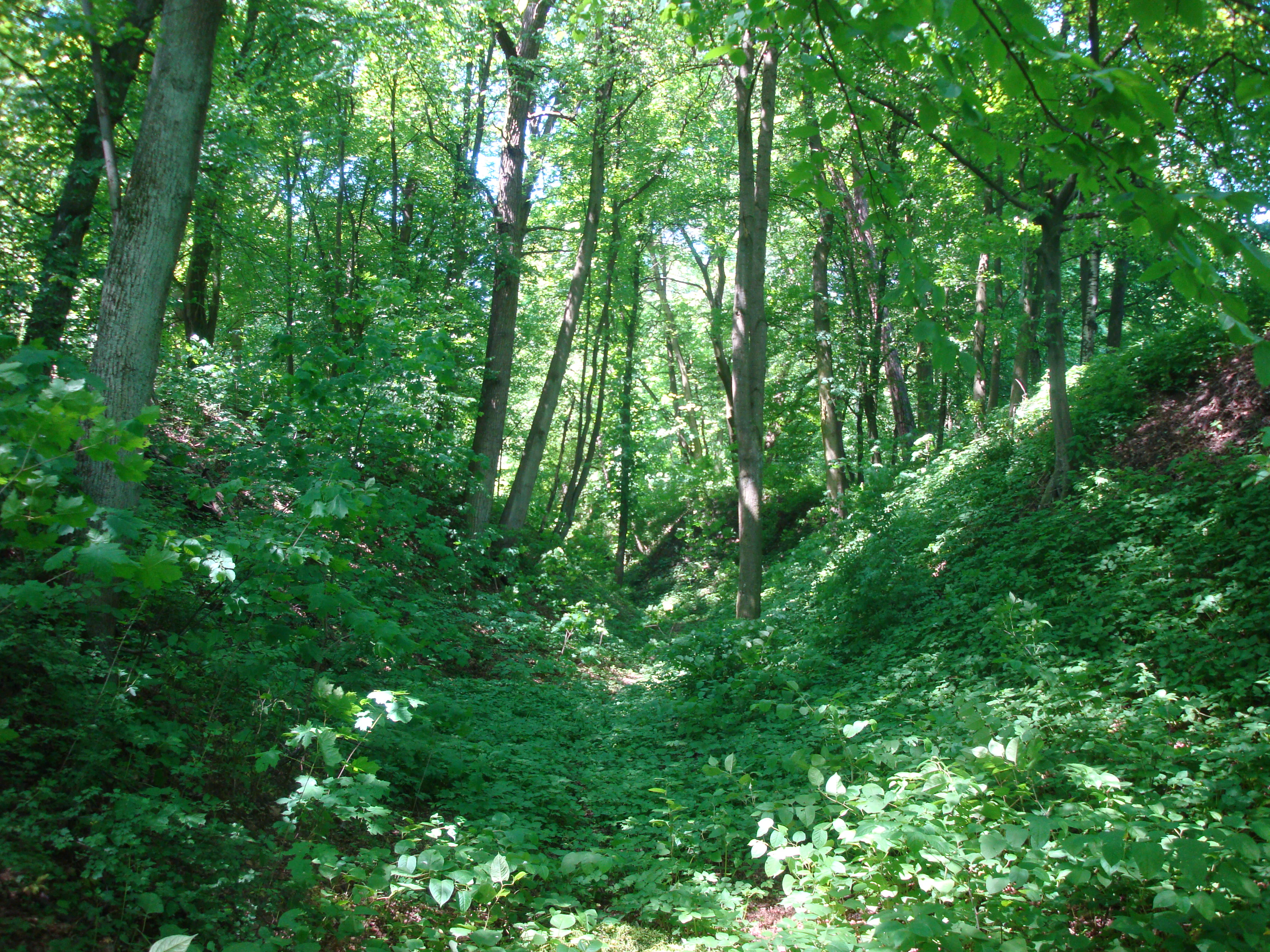
A narrow, wooded ravine or gorge floor covered in green vegetation, surrounded by steep earth banks and tall deciduous trees in sunlight.
A lush, green loess ravine within the forested landscape of Wrzelowiecki Park Krajobrazowy.

Wrzelowiecki Park Krajobrazowy history and protected-area timeline

Wrzelowiecki Park Krajobrazowy was established by resolution of the provincial council in Lublin on 26 February 1990, under reference Uchwała Nr XI/56/90, as part of a wave of Polish landscape park designations intended to protect representative rural and upland landscapes experiencing agricultural and land-use change.

The choice of the protected area reflects long-standing recognition of the scenic and cultural value of the northern Wzniesienia Urzędowskie. Orcharding and arable farming on the fertile brown soils had shaped the visible character of these hills for generations, while the loess gorges, forested valleys, and exposures of Cretaceous rock along the Vistula provided strong natural assets. Designating the park allowed formal coordination of nature, landscape, and cultural-heritage protection across the gminas of Łaziska, Opole Lubelskie, and Józefów nad Wisłą.

Cultural landmarks within the protected area, including the Stanisław Witkiewicz-designed palace at Kluczkowice, the Bernardine-era complex at Józefów nad Wisłą, the Gothic church at Piotrawin founded through Cardinal Zbigniew Oleśnicki in the 1440s, and monuments linked to the January Uprising at Chruślina, predate the park itself but fall within its conservation remit. The park thus integrates centuries of local history, from medieval church foundations and post-Bernardine Baroque architecture to 19th-century uprisings and manor estates, into a unified landscape framework.

Wrzelowiecki Park Krajobrazowy landscape and geographic character

The landscape of Wrzelowiecki Park Krajobrazowy is shaped by its position on the right bank of the Vistula and by the rolling relief of the Wzniesienia Urzędowskie. The northern edge of the park meets the river's edge through a slope cut into Cretaceous bedrock, where sedimentary layers and fossil-bearing rocks are exposed and visible in numerous outcrops. This geological contact gives the northern frontier of the park a distinctly sharp and stratified character.

Inland from the Vistula slope, the park's hills are mantled with loess, a fine-grained wind-deposited sediment that has been reworked by water over thousands of years. The result is a system of slopes, ravines, and gullies, including the dramatic loess gorge near Kluczkowice-Osiedle. These incised landforms create contrasting topography: broad, smooth ridges and valley shoulders set against steep, narrow cuts where erosion has exposed raw loess walls.

The brown soils developed on top of these deposits are notably fertile, supporting orchards and mixed farmland that historically covered much of the upland. Combined with extensive forest stands, especially hornbeam-oak and pine-oak communities, the result is a shifting mosaic of groves, fields, hedgerows, hamlets, and steep ravines. This patchwork of land uses, rather than any single dramatic peak or coastline, defines the visual identity of the park.

Wrzelowiecki Park Krajobrazowy ecosystems, habitats, and plant life

Ecologically, the park belongs to the temperate broadleaf forest belt of Central Europe, mapped at the regional level within the Wzniesienia Urzędowskie. Mixed deciduous woods dominated by hornbeam, oak, and birch, together with more open pine-oak communities, cover more than a third of the protected area. Their distribution reflects both soil conditions and long-term forest management, producing differing understory character and habitat structure across the park.

The varied geology of the area supports a range of plant communities. Along the Cretaceous exposures near the Vistula, dry calcareous and warm-edge habitats occur, while the loess and brown-soil slopes elsewhere support richer mesophilic woodland. Several protected and regionally notable plant species are present, notably the Martagon lily, Moldavian monkshood, and the interrupted clubmoss. These species underscore the conservation value of the woodland beyond being simply a backdrop for the cultural landscape.

A particular natural asset is the Kaliszańskie Islands near Kaliszany, a wetland area set in an otherwise upland-dominated park. This refuge supports waterbird and marshland species adapted to standing-water and floodplain conditions, adding a clear wetland element to the park's natural profile and reinforcing its ecological diversity within a relatively compact geographic area.

Wrzelowiecki Park Krajobrazowy wildlife and species highlights

The woodlands of the park host a community of mammals characteristic of Central European mixed forests. The hazel dormouse, a small arboreal rodent tied to well-structured deciduous woodland with fruiting understory, is among the notable small mammals recorded. Larger carnivores and omnivores typical of similar forest complexes in the region are also present, including the European badger and members of the marten family. While not framed in the source material as a wildlife spectacle park, this baseline of forest fauna gives the area genuine mammal-watching potential in quieter seasons.

Birdlife within the park is shaped by the contrast between its forests and open farmland, as well as by the wetland complex at the Kaliszańskie Islands near Kaliszany. The waters and associated reedbeds there constitute an identified refuge for waterfowl and marshland birds, offering habitat for species that would not otherwise occur in a predominantly upland, agricultural protected area. This single wetland pocket significantly strengthens the bird-related interest of the park.

Beyond the mammals and birds, the fossil record exposed within Cretaceous strata of the park records past marine life such as sponges, bivalves, corals, and ammonites. While these are paleontological rather than living wildlife, they form an important part of how the park's natural story is communicated, linking current forests and farmland to the marine past embedded in the bedrock of the Vistula slope.

Wrzelowiecki Park Krajobrazowy conservation status and protection priorities

As a Polish landscape park, Wrzelowiecki Park Krajobrazowy belongs to a category of protected area designed to maintain the interplay between natural habitats and cultural land use, rather than to impose wilderness-level restrictions. Its core area of roughly 49.89 square kilometers, combined with a buffer zone of about 136.25 square kilometers, extends the effective influence of protection well beyond the strictly delimited interior, helping to manage land-use transitions around the park's edges.

The park's conservation value rests on several reinforcing elements: the protection of representative hornbeam-oak and pine-oak woodland communities of the Wzniesienia Urzędowskie; the conservation of regionally rare plant species such as the Martagon lily, Moldavian monkshood, and interrupted clubmoss; and the safeguarding of the fossil-bearing Cretaceous exposures along the Vistula, which represent a significant geological heritage. The Kaliszańskie Islands wetland further adds a focused habitat-conservation dimension within an otherwise upland area.

Cultural-heritage conservation is woven into the park's mandate through the protection of its villages, manor houses, and historic churches, including the Witkiewicz-designed palace at Kluczkowice, the Baroque post-Bernardine complex at Józefów nad Wisłą, the Gothic church at Piotrawin, and the Renaissance-era church at Rybitwy. By binding ecological and cultural protection together, the park reflects the integrated logic of Poland's landscape park system.

Wrzelowiecki Park Krajobrazowy cultural meaning and human context

The cultural context of Wrzelowiecki Park Krajobrazowy is shaped by centuries of human settlement on the fertile soils of the Wzniesienia Urzędowskie. Long-established orchards and small-scale farming have produced a working agricultural landscape that is valued as an element of the park's identity, rather than a contrast to its natural values.

Several villages and small towns within the park carry significant historical architecture. Józefów nad Wisłą preserves a Baroque post-Bernardine complex founded by Józef Potocki in the first half of the 18th century, with a 19th-century palace and remains of a 17th-century castle. Kluczkowice-Osiedle features a 19th-century palace designed by the architect Stanisław Witkiewicz and an associated park. Piotrawin has a Gothic church dating to the 1440s, founded through Cardinal Zbigniew Oleśnicki, and a parish collection of 17th-century votive paintings. Wrzelowiec, Rybitwy, and Chruślina each contribute further layers of religious, domestic, and memorial architecture, including monuments to the 1863 January Uprising.

Together, these elements frame the park as a place where rural productive life, manor estates, sacred architecture, and memorial landscapes are protected alongside forests and loess gorges. The cultural layer is not peripheral but inseparable from how the park's landscape is read and understood.

Top sights and standout views in Wrzelowiecki Park Krajobrazowy

Among the strongest points of distinction of Wrzelowiecki Park Krajobrazowy is the contrast between steep loess ravines, including the notably developed gorge near Kluczkowice-Osiedle, and the broader forested ridges of the Wzniesienia Urzędowskie, all within a relatively compact protected area. The park also combines two distinct kinds of natural interest: the terrestrial hornbeam-oak and pine-oak woodlands on the upland, and the wetland bird refuge of the Kaliszańskie Islands near Kaliszany.

Equally distinctive is the geological reading along the Vistula slope, where Cretaceous exposures carry marine fossils of sponges, bivalves, corals, and ammonites, and the productive agricultural tradition supported by brown soils, especially orchards. Layered onto these natural assets is a string of historic villages whose architecture and religious foundations span the Gothic, Baroque, Classicism, and the 19th century, capped by 19th-century monuments to the January Uprising. The combination is rare within a single Polish landscape park of this size.

Best time to visit Wrzelowiecki Park Krajobrazowy

The park's character shifts with the seasons in ways that reflect both its agricultural mosaic and its mixed deciduous forest. Late spring and early summer are typically the most striking time for woodland wildflowers, including protected species such as the Martagon lily and Moldavian monkshood, while forest cover is fully leafed out and the loess gorges are at their greenest.

Early autumn brings the parallel color changes of the hornbeam-oak forests and the working orchards that line many of the slopes, producing a layered palette across ridges and farmland. Winter, with reduced agricultural activity and clearer visibility into the ravines, can sharpen the geological reading of the park and reveal the relief of the loess gorges. Birdwatchers may find particular interest around the Kaliszańskie Islands during migration periods, when seasonal waterfowl use the wetlands.

Monthly climate preview

Long term representative point measurements for temperature and precipitation patterns

Wrzelowiecki Park Krajobrazowy Climate Normals and Annual Temperature Rhythm

Representative coordinates record an annual temperature range spanning from winter mean lows to summer maximums alongside measured monthly precipitation rates. Detailed twelve month climate profiles provide deeper analytical context for long term atmospheric conditions across the protected landscape.
Annual mean8 °C
-4 °C20 °C
Jan-4°
Feb-2°
Mar
Apr
May14°
Jun18°
Jul20°
Aug20°
Sep14°
Oct
Nov
Dec-2°
Warmest month
July

20.3 °C

Coolest month
January

-3.8 °C

Wettest month
July

2.7 mm/day

Driest month
January

1.2 mm/day

Park location guide

Geography guide, regional context, and park location map for Wrzelowiecki Park Krajobrazowy

Wrzelowiecki Park Krajobrazowy park geography, regions, and map view in Poland

Understand where Wrzelowiecki Park Krajobrazowy sits in Poland through a broader geographic reading of the surrounding landscape, nearby location context, and its mapped position within the national park landscape.

How Wrzelowiecki Park Krajobrazowy fits into Poland

Poland, officially the Republic of Poland, is a Central European country spanning from the Baltic Sea in the north to the Carpathian Mountains in the south. It borders Germany, Czech Republic, Slovakia, Ukraine, Belarus, Lithuania, and Kaliningrad Oblast. The country has a temperate climate, diverse landscapes, and is known for its rich history, cultural heritage, and strong economic position within the EU.

Wider geography shaping Wrzelowiecki Park Krajobrazowy in Poland

Poland occupies 312,696 km2 in Central Europe, extending from the Baltic Sea coast in the north to the Sudetes and Carpathian Mountains in the south. It borders Germany to the west, Czech Republic and Slovakia to the south, Ukraine and Belarus to the east, and Lithuania and Kaliningrad Oblast to the northeast. The landscape includes lowland plains, uplands, and mountain ranges.

Map view of Wrzelowiecki Park Krajobrazowy

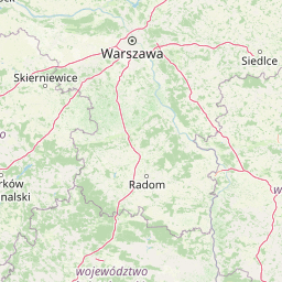
Use this park location map to pinpoint Wrzelowiecki Park Krajobrazowy in Poland, understand its exact geographic position, and read its mapped placement within the surrounding landscape more clearly.

Pigeon | © OpenStreetMap contributors

Location context for Wrzelowiecki Park Krajobrazowy

Lubelskie Voivodeship

Visual reference collection for loess gorges, upland relief, and Vistula valley terrain

Wrzelowiecki Park Krajobrazowy Photos and Protected Landscape Scenery

Visual documentation captures the dramatic loess ravines, mixed deciduous forests, and exposed Cretaceous bedrock formations defining the protected terrain. Detailed photography reveals the unique topography and ecological character of the upland hills along the Vistula river.

A narrow, wooded ravine or gorge floor covered in green vegetation, surrounded by steep earth banks and tall deciduous trees in sunlight.

Park atlas

Compare regional upland geography and connected conservation areas across eastern Poland

Parks Near Wrzelowiecki Park Krajobrazowy and Surrounding Protected Landscapes

Browsing other protected areas near Wrzelowiecki Park Krajobrazowy reveals broader patterns in upland terrain and river valley ecosystems. Extending regional comparison helps trace connected woodland habitats and geological formations across the surrounding countryside.
Nature reserveLubelskie Voivodeship
About 25 km away#1 closest

South

Szczecyn Nature Reserve: Mapping Protected Deciduous Forest Habitats in Eastern Poland

A vital mosaic of oak-hornbeam forest enclaves and nature reserves.

Szczecyn functions as a specialized Natura 2000 conservation landscape, spanning four forest enclaves across the border of the Lubelskie and Podkarpackie voivodeships. This site provides an essential reference for lowland deciduous forest protection, emphasizing the preservation of old-growth oak-hornbeam stands and thermophilic habitats. The area serves as a critical refuge for rare flora and invertebrates within a broader agricultural mosaic.

Area
9.325 km²
Established
2011
Relief
Upland
Climate
Temperate
Nature reserveLublin Voivodeship
About 26 km away#2 closest

Southeast

Rezerwat przyrody Marynopole: Mapping the Upland Forest Landscapes of Lublin Voivodeship

Protected silver fir and oak stands in the Wzniesienia Urzędowskie hills

Rezerwat przyrody Marynopole acts as a critical conservation site for silver fir and mature oak forest within the Lublin Voivodeship of southeastern Poland. This nature reserve offers deep insight into upland ecology, protecting old-growth stands that thrive across the rolling, loamy terrain of the Wzniesienia Urzędowskie mesoregion.

Area
1.57 km²
Established
1976
Relief
Upland
Scope
Terrestrial
Nature reserveŚwiętokrzyskie Voivodeship
About 26 km away#3 closest

West

Rezerwat przyrody Modrzewie: Protected Oak-Lime and Polish Larch Forest Reserve

Forest landscape discovery in the Świętokrzyskie region of Poland.

Located in the Kamienna Valley, Rezerwat przyrody Modrzewie acts as a vital protected area for mature, near-primary oak-lime forest. This nature reserve provides essential botanical context for the Polish larch, embedding a rich woodland fragment within the wider geographical tapestry of the Świętokrzyskie Voivodeship.

Area
0.047 km²
Established
1971
Relief
Lowland
Climate
Temperate
Nature reserveLublin Voivodeship
About 26 km away#4 closest

North

Rezerwat przyrody Mięćmierz: Protected Xerothermic Habitats and Vistula River Geography

Nature reserve landscape and ecological atlas overview

Rezerwat przyrody Mięćmierz represents a critical fragment of xerothermic grassland in the Lublin region of Poland. Formed in 2023, this nature reserve protects calcium-rich slopes and rare plant populations overlooking the Małopolska Vistula Gorge. Examine the geography of its dual-enclave structure, where steep loess and limestone terrain creates open habitats for diverse protected species within the Kazimierski Landscape Park.

Area
0.117 km²
Established
2023
Relief
Upland
Climate
Temperate
Nature reserveLublin Voivodeship
About 29 km away#5 closest

South

Rezerwat przyrody Doły Szczeckie: Upland Forest and Karst Landscape Geography in Lublin Voivodeship

A protected nature reserve featuring distinct ravine systems and ancient beech stands

Rezerwat przyrody Doły Szczeckie is defined by its dissected, scenic karst terrain featuring a network of dry valleys and deep gorges. Located in the Lublin Voivodeship, this nature reserve protects significant stands of European beech and hornbeam that anchor the region's broader broadleaf forest identity. Use this data to understand the elevation shifts and boundaries that shape this distinct patch of protected Polish landscape.

Area
2.036 km²
Established
1997
Relief
Upland
Scope
Terrestrial
Protected areaPoland
About 37 km away#6 closest

Southeast

Uroczyska Lasów Janowskich: Protected Forest and Wetland Geography in Eastern Poland

Mapping the extensive Natura 2000 lowland forest and peatland complexes

Spanning the Biłgoraj Plain and San River valley, Uroczyska Lasów Janowskich is a notable lowland forest complex in Poland. Its terrain integrates mature oak-hornbeam woods with diverse peatland systems, offering a clear look at how layered conservation strategies protect rare European habitats within a single continuous geographic block.

Area
345.443 km²
Established
2009
Relief
Lowland
Climate
Temperate
Protected areaŚwiętokrzyskie Voivodeship
About 42 km away#7 closest

West

Wzgórza Kunowskie: Geographic Atlas of an Essential Polish Protected Area and Habitat Mosaic

Mapping riparian forests and inland dunes in Świętokrzyskie

Wzgórza Kunowskie serves as a crucial Natura 2000 site in Poland, blending sand grasslands, oak-hornbeam forests, and riverine floodplains within a compact landscape. This overview analyzes the topographical gradients and habitat distribution that define the area, from elevated dunes to the moisture-rich valley floors of the Świętokrzyskie region, reflecting the interplay between sandy substrate and river regulation.

Area
18.687 km²
Water
Major water bodies
Protected landscapeTarnobrzeska Dolina Wisły
About 44 km away#8 closest

South

Tarnobrzeska Dolina Wisły Protected Landscape: Mapped Riverine Geography and Habitat Corridor

A sprawling Vistula valley floodplain site in southeastern Poland.

The Tarnobrzeska Dolina Wisły protected area encompasses a 4,060-hectare corridor of rare lowland habitats. This map-focused site highlights an ecologically active river system composed of riparian forests, shifting banks, and extensive wetlands that define the regional geography of the middle Vistula basin.

Area
40.597 km²
Established
2011
Scope
Terrestrial
Water
Major water bodies

Common questions about visiting, size, designation, and location context for Wrzelowiecki Park Krajobrazowy

Wrzelowiecki Park Krajobrazowy FAQs for park facts, access, geography, and protected area context

Find quick answers about Wrzelowiecki Park Krajobrazowy, including protected-area facts, park geography, trail and visitor context, and how the park fits into its surrounding country and regional landscape.
MoriAtlas Explorer

Continue Your Protected Areas Search Across the Global Atlas

Deepen your exploration by continuing the structured search for national parks and protected areas worldwide. Utilize the comprehensive filtering capabilities to compare different conservation landscapes and refine your understanding of global park geography. Discover more about the distribution and characteristics of protected natural areas.

Global natural geography