

Mori Atlas logo
Natural monumentAbercrombie Caves

Explore the geography of the largest natural arch in the southern hemisphere and unique karst cave systems

Abercrombie Caves: A Significant Karst Natural Monument and Protected Landscape in the Abercrombie Ranges

(Abercrombie Karst Conservation Reserve)

Located in the rugged foothills of the Abercrombie Ranges in Central West New South Wales, Abercrombie Caves represent a complex karst system defined by limestone bedrock and extensive water erosion. This natural monument encompasses a series of high-roofed chambers and rare crayback rock formations, providing a window into the geological evolution of sinkholes and blind valleys within the Australian landscape. The site serves as a vital record of both natural karst morphology and nineteenth-century human history, featuring historical mining structures embedded within a protected environmental reserve.

limestone caveskarst landscapenatural archcave systemCentral West NSWgeological heritage

Abercrombie Caves

Natural monument

Park overview

Structured park overview, official facts, and landscape profile for Abercrombie Caves

Abercrombie Caves park facts, protected area profile, and essential visitor context

Review the core facts for Abercrombie Caves, including designation, size, terrain, visitor scale, habitats, and operating context in one park-focused overview.

About Abercrombie Caves

Abercrombie Caves are the defining feature of the Abercrombie Karst Conservation Reserve, a protected area in the Central West region of New South Wales, Australia. The reserve covers approximately 1,434 hectares of rugged terrain within the Abercrombie Ranges, sitting in the countryside between Bathurst to the north and Goulburn to the south, and near the small historic village of Trunkey Creek. The protected area was formally established in December 1997 and is classified as an IUCN Category III natural monument or feature, recognising the outstanding geological significance of the cave system.

The caves themselves are solutional limestone caves, carved by water action over a long period. The defining karst feature of the reserve is a formation that began as a sinkhole and was progressively eroded into a blind valley, a valley that abruptly terminates where water sinks underground rather than flowing out as a stream, creating dramatic passage openings. Both entrances display strong examples of crayback formations, a relatively unusual solutional sculpting pattern that gives those sections of the caves a distinct, ridged appearance.

The reserve is significant not only for a single chamber but for a suite of named caves, each with its own character. The Archway is the centrepiece and the most-visited feature, easily accessible and famous for the historic dance platform inside it. Belfry Cave offers high-roofed chambers with ladders, squeezes, and a suspension bridge for more adventurous visitors. Grove Cave provides a challenging guided experience through tight passages and white-walled chambers. King Solomon's Temple and the Bushranger's Cave share a connected system with a strong historical identity tied to 19th-century bushrangers, while Cathedral Cave adds to the geological diversity of the site.

The setting and the surrounding landscape reinforce the park's identity. The caves lie within deeply dissected country in the Abercrombie Ranges, where steep forested slopes frame the entrances and create a cool, sheltered microclimate inside the cave passages. The reserve supports camping and a small number of visitor cottages, along with a network of guided cave tours, and all cave access is conducted by guided tour only to protect the fragile formations and manage visitor safety across the varied cave terrain.

Quick facts and research context for Abercrombie Caves

Abercrombie Caves lie in the Central West of New South Wales, roughly 75 kilometres south of Bathurst and 125 kilometres north of Goulburn, near the village of Trunkey Creek. The site is protected as the Abercrombie Karst Conservation Reserve, a 1,434-hectare area established in December 1997 and classified as an IUCN Category III protected area (natural monument or feature). The geology is limestone, shaped by water erosion into a classic karst landscape that includes a sinkhole that evolved into a blind valley.

The caves themselves were first officially recorded in 1842 by Surveyor W. R. Davidson, with additional chambers discovered the following year, and carry a layered history tied to bushrangers, gold miners, and later tourist visitation. The principal feature, The Archway, is recognised as the largest natural arch in the southern hemisphere, and all cave access is by guided tour only.

Protection and recognition

Documented terrestrial protection scope and conservation designation details

Abercrombie Caves Protection Status and International Recognition Records

Abercrombie Caves maintains a documented terrestrial protection scope without imported international recognition sources. Official conservation records outline the baseline protected area framework governing the local landscape.

Protection details

Protection scope
Terrestrial
Transboundary protection
No
Park context

Deeper park guide and search-rich context for Abercrombie Caves

Abercrombie Caves history, landscape, wildlife, and travel context

Explore Abercrombie Caves through its history, landscape character, ecosystems, wildlife, conservation priorities, cultural context, and seasonal travel timing in a structured park guide built for atlas discovery and search intent.

Why Abercrombie Caves stands out

Abercrombie Caves are best known for The Archway, the largest natural arch in the southern hemisphere, formed where water erosion has opened a massive limestone span above a former stream passage. The site is equally recognised for its exemplary karst geomorphology, particularly the evolution of a sinkhole into a blind valley and the rare presence of crayback formations, which are fluted, sharp-ridged rock shapes sculpted by flowing water, at both main entrances. Beyond the geology, the caves carry a strong cultural footprint: a historic gold miners' dance platform built in 1880 still hosts performances inside The Archway, and several chambers bear names drawn from 19th-century bushranger history. The combination of significant karst features, large-scale cave morphology, and layered human stories gives the reserve a distinctive identity among New South Wales cave systems.
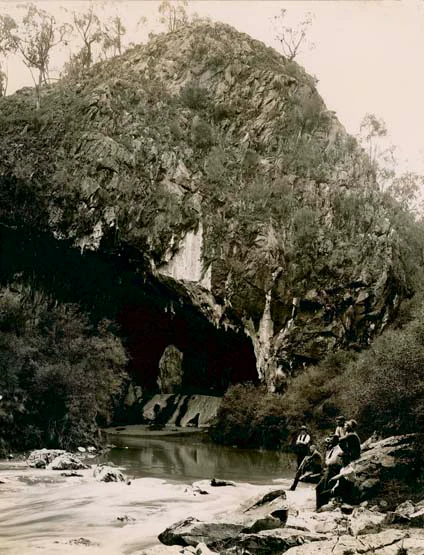
A vintage sepia-toned photograph showing a large limestone archway opening at the base of a rocky, tree-covered hillside, with a stream in the foreground and a group of people sitting on rocks nearby.
Historical photograph of the entrance to the Abercrombie Caves.

Abercrombie Caves history and protected-area timeline

The human history of Abercrombie Caves stretches back to at least the early 1830s and has shaped both the popular imagination and the physical fabric of the site. It is believed that a tourist party visited the caves as early as 1834, but the system was not officially recorded until 1842, when Surveyor W. R. Davidson documented it. The following year, Surveyor Wells extended the known chambers, discovering the Koh-i-noor, Bushranger, Long Tunnel, and Cathedral caves, along with the Hall of Terpsichore, also known as The Dance Hall. In 1844 the explorer William Wentworth and Governor Charles FitzRoy visited the caves, an early indication of the site's status as a destination of public interest.

The caves became entangled with the bushranger era of New South Wales. Various bushrangers used the system as a hideout during the 1800s, with the earliest known group being the Ribbon Gang in 1830. Composed of escaped convicts and led by the young English convict-servant Ralph Entwistle, the gang took advantage of the caves' remote location and narrow passages. The Bushranger's Cave, connected to the King Solomon's Temple chamber, still carries this history in its name and identity.

The discovery of gold in the area in 1854 transformed the local landscape. A gold exploration community was established at Mount Gray, just above the caves, and miners from surrounding districts frequently visited the caves for recreation. During this period the caves, originally known as Burragylong Caverns, came to be called Abercrombie Caves. The miners left their mark on the site in ways that are still visible: a dance platform was built inside The Archway in the 1860s and replaced in January 1880 with the structure that still stands, used today for performances, including the annual Carols in the Caves. The mining era also brought damage, as some miners fired rifles at the formations and early visitors carried away pieces of white marble as souvenirs; 19th-century graffiti name carvings can still be seen inside the caves.

The site's modern protection came with the establishment of the Abercrombie Karst Conservation Reserve in December 1997, recognising the caves' value as a natural heritage site listed on the Register of the National Estate for the diversity of its karst morphological and sedimentological features. Today the reserve is jointly managed by the Jenolan Caves Reserve Trust and the NSW National Parks and Wildlife Service, with all cave access provided through guided tours.

Abercrombie Caves landscape and geographic character

The landscape of the Abercrombie Caves reserve is defined by the rugged terrain of the Abercrombie Ranges in the Central West of New South Wales. The 1,434-hectare reserve sits in deeply dissected country, where forested ridges and steep slopes enclose a network of valleys shaped by limestone bedrock and underground drainage. The caves themselves are the surface expression of a karst system in which surface water has, over long periods, dissolved pathways through the rock, leaving behind a terrain of sinkholes, blind valleys, and solutionally sculpted cave entrances.

The most striking single landscape element is The Archway, a vast natural limestone span formed where a former cave passage was opened to the sky by erosion. Recognised as the largest natural arch in the southern hemisphere, The Archway resembles a natural bridge across the valley floor, with the cave continuing into the hillside behind it. Surrounding chambers, including Cathedral Cave and the connected Bushranger's Cave/King Solomon's Temple system, extend the landscape underground, where high chambers, narrow squeezes, and white-walled passages form contrasting environments within the same limestone block.

At both main entrances, the rock surfaces are shaped into crayback formations, sharp, parallel ridges and grooves carved by flowing water. These features are relatively uncommon and contribute significantly to the visual and scientific character of the site. Above ground, the reserve's mix of forested slopes, grassy clearings, and valley floors provides the visual frame for the cave entrances and supports the camping and visitor areas that give the reserve its present-day role as both a natural monument and a place of public recreation.

Abercrombie Caves ecosystems, habitats, and plant life

The ecological identity of the Abercrombie Caves reserve is closely tied to its limestone geology and the way that karst landscapes shape vegetation, water, and habitat. Limestone terrain typically produces distinctive surface conditions, with thinner soils, altered drainage patterns, and vegetation communities adapted to rocky, sometimes drought-prone substrates, reflected in the mix of forest and open woodland that covers the Abercrombie Ranges above and around the caves.

The most ecologically distinctive elements of the reserve are not at the surface but within the cave system itself. Cave environments support specialised ecological communities adapted to darkness, high humidity, and stable temperatures, and the network of passages at Abercrombie offers a range of microhabitats from wide, airy chambers like The Archway and Belfry Cave to tight squeezes and white-walled passages such as those of Grove Cave. The presence of crayback formations at the entrances, solutional features shaped by sustained water flow, indicates active hydrological processes that continue to influence conditions both inside the caves and in the surrounding terrain.

The broader reserve contributes to habitat connectivity in the Central West, with forested ridges and valleys providing cover for native fauna and helping to maintain water quality in the catchment that feeds the karst system. While the reserve is primarily recognised for its geological values, the surrounding landscape forms an integral part of the protected area, supporting the ecological processes that sustain the cave system and the species associated with it.

Abercrombie Caves wildlife and species highlights

Wildlife observations at Abercrombie Caves are shaped by the contrast between the forested ridges of the Abercrombie Ranges above ground and the sheltered, stable microclimate of the limestone caves below. The reserve's mix of eucalyptus woodland, rocky slopes, and valley floors provides habitat for forest and woodland species typical of the Central West region of New South Wales, while the cave system itself supports the specialist communities that depend on dark, humid underground conditions.

Because the reserve's primary recognition is for its karst geology and cultural history rather than for charismatic megafauna, the wildlife dimension is best understood in terms of habitat contribution rather than headline species. The forested terrain around the entrances provides cover and foraging resources for native birds, small mammals, and reptiles characteristic of the region, while the caves host invertebrates and other cave-dwelling fauna adapted to the underground environment. This dual character, surface habitat for regional woodland species combined with underground habitat for cave specialists, gives the reserve a layered ecological profile uncommon among Australian cave sites.

Abercrombie Caves conservation status and protection priorities

The conservation significance of Abercrombie Caves centres on the protection of an outstanding limestone karst system in New South Wales. The caves were formally protected through the establishment of the Abercrombie Karst Conservation Reserve in December 1997, an area of approximately 1,434 hectares classified as an IUCN Category III protected area, recognising it as a natural monument or feature of national significance.

The reserve is listed on the Register of the National Estate for the diversity of its karst morphological and sedimentological features, an acknowledgement of the scientific value of the system for understanding how limestone landscapes evolve through processes such as sinkhole development, blind valley formation, and crayback sculpting. These features are not only visually distinctive but also scientifically informative, offering insight into long-term groundwater behaviour and surface-subsurface interactions.

Conservation management is shared between the Jenolan Caves Reserve Trust and the NSW National Parks and Wildlife Service. Access to all caves is restricted to guided tours, a measure that serves both visitor safety and the protection of fragile formations. The damage caused in earlier eras, including souvenir removal, rifle damage to formations, and 19th-century graffiti, stands as a reminder of why active management and controlled access remain central to protecting the site for future generations.

Abercrombie Caves cultural meaning and human context

The cultural identity of Abercrombie Caves is inseparable from the broader history of the Central West region of New South Wales. The site carries layers of human meaning from early colonial exploration, the bushranger era, the gold rush, and the development of tourism and cultural performance traditions, all inscribed into both the place names of the caves and the physical fabric of the site itself.

The bushranger connection is particularly strong. The Bushranger's Cave, connected with the King Solomon's Temple chamber, takes its identity from bands of bushrangers who roamed the Abercrombie Ranges in the 1830s, including the Ribbon Gang led by the young English convict Ralph Entwistle. The remote location and narrow passages of the cave system made it an ideal shelter, and this history remains part of how the site is interpreted today.

The gold rush period left a different but equally enduring mark. After gold was discovered in the area in 1854, miners built a community at Mount Gray above the caves and regularly visited them for recreation. Inside The Archway, they built a dance platform that was replaced in January 1880 with the structure still standing today, used for ongoing community performances including the annual Carols in the Caves. The earlier name Burragylong Caverns and the legacy of 19th-century graffiti carvings within the caves further tie the site to the lived history of the region, giving Abercrombie Caves a cultural depth unusual among Australian cave reserves.

Top sights and standout views in Abercrombie Caves

The standout features of Abercrombie Caves begin with The Archway, the largest natural arch in the southern hemisphere, and the historic miners' dance platform from 1880 that still hosts performances inside it. Equally distinctive are the crayback formations at both main entrances, a relatively rare solutional sculpting pattern, and the broader karst story of a sinkhole evolving into a blind valley, evidence of the long-term water action that shaped the entire system.

Beyond the geology, the reserve offers a layered cultural experience through the named chambers: King Solomon's Temple reached via a suspension bridge, the high-roofed challenge of Belfry Cave, the tight white-walled passages of Grove Cave, and the bushranger-history-rich Bushranger's Cave. Combined with the surrounding forested terrain of the Abercrombie Ranges and the site's protected status within the Abercrombie Karst Conservation Reserve, these features make Abercrombie Caves a place where natural heritage and 19th-century human history are physically and visibly intertwined.

Best time to visit Abercrombie Caves

Abercrombie Caves are best experienced in conditions that allow comfortable movement through outdoor walks to the cave entrances and enjoyable time in the cool underground environment. The Central West of New South Wales has a temperate climate with warm to hot summers and cooler winters, and visiting in the cooler months can make the active cave tours, especially the more strenuous Grove Cave and Bushranger's Cave/King Solomon's Temple tours, considerably more pleasant.

Cave interior temperatures remain relatively stable year-round, offering a cool refuge during summer heat, while spring and autumn typically provide mild surface conditions ideal for combining cave tours with walking the reserve grounds and enjoying the surrounding forested landscape. Winter visits can also be rewarding, particularly for those interested in atmospheric cave photography and quiet exploration, though visitors should be prepared for cooler surface temperatures. Access to the caves is most flexible during New South Wales school holidays, when the site is open seven days a week, while term-time visits are limited by weekly closure days.

Monthly climate preview

Long-term representative temperature and precipitation averages by month

Abercrombie Caves Annual Climate Normals and Temperature Rhythms

Abercrombie Caves experiences a measured annual climate cycle spanning mild to warm temperatures alongside consistent monthly precipitation patterns based on historical data. Examining the complete twelve-month profile provides detailed monthly normals for long-term meteorological analysis.
Annual mean13 °C
5 °C22 °C
Jan22°
Feb20°
Mar17°
Apr13°
May
Jun
Jul
Aug
Sep10°
Oct13°
Nov16°
Dec19°
Warmest month
January

21.6 °C

Coolest month
July

5.4 °C

Wettest month
February

2.6 mm/day

Driest month
April

1.1 mm/day

Park location guide

Geography guide, regional context, and park location map for Abercrombie Caves

Abercrombie Caves park geography, regions, and map view in Australia

Understand where Abercrombie Caves sits in Australia through a broader geographic reading of the surrounding landscape, nearby location context, and its mapped position within the national park landscape.

How Abercrombie Caves fits into Australia

Australia is a constitutional monarchy and federal parliamentary democracy comprising six states and ten territories. With a population of nearly 28 million, it is one of the world's most urbanised countries, with most people concentrated on the eastern seaboard. The country has a high Human Development Index and is known for its cultural diversity, ancient Aboriginal heritage, and unique wildlife.

Wider geography shaping Abercrombie Caves in Australia

Australia occupies the entire Australian continent, the island of Tasmania, and numerous smaller islands. It is the world's flattest and driest inhabited continent, featuring vast deserts in the interior (the Outback), tropical rainforests along the eastern coast, and a coastline bordering the Indian and Pacific Oceans.

Map view of Abercrombie Caves

Use this park location map to pinpoint Abercrombie Caves in Australia, understand its exact geographic position, and read its mapped placement within the surrounding landscape more clearly.

Pigeon | © OpenStreetMap contributors

Location context for Abercrombie Caves

New South Wales

Visual reference guide to limestone arches, karst formations, and protected valley terrain

Abercrombie Caves Photos and Landscape Scenery Explorer

Browse detailed park photography showcasing the massive natural limestone arches, rugged forested ridges, and sculpted rock formations of Abercrombie Caves. Visual records help researchers and travelers examine the complex geomorphology and protected landscape character of the New South Wales karst reserve.

A vintage sepia-toned photograph showing a large limestone archway opening at the base of a rocky, tree-covered hillside, with a stream in the foreground and a group of people sitting on rocks nearby.

Park atlas

Compare regional protected areas and discover connected terrain across New South Wales.

Exploring Parks Near Abercrombie Caves and Surrounding Protected Landscapes

Browsing parks near Abercrombie Caves reveals diverse geological formations and rugged conservation reserves throughout the surrounding region. Extending the geographic comparison helps trace broader protected landscape patterns and regional park networks.
National parkNew South Wales
About 18 km away#1 closest

Southeast

Abercrombie River National Park: A Protected Landscape in New South Wales

Explore its national park designation and mapped geography.

Delve into the details of Abercrombie River National Park, a designated national park situated in New South Wales. This entry focuses on its identity as a protected landscape, providing a geographically specific atlas perspective. Understand the extent of its mapped boundaries and its contribution to the regional geography, offering a clear view of its protected area status for discovery and reference.

Area
190 km²
Established
1995
IUCN
II
Relief
Mountain
National parkNew South Wales
About 56 km away#2 closest

East

Kanangra-Boyd National Park: A Protected Landscape within New South Wales' Geography

Mapped boundaries and regional park context.

Kanangra-Boyd National Park represents a significant protected area, offering valuable insights into the natural landscapes and geographic context of New South Wales. As a national park, it provides a clear example of mapped terrain and protected land distribution, crucial for anyone exploring the atlas of Australian conservation areas. Understanding this park contributes to a broader appreciation of its regional geography and specific landscape identity.

Area
686.6 km²
Established
1969
IUCN
Ib
Relief
Mountain
A horizontal watercolor painting showing layers of rolling hills in shades of green, yellow, and soft pink against a white background.
Nature reserveNew South Wales
About 62 km away#3 closest

East

Jenolan Karst Conservation Reserve: Atlas and Geographic Landscape Profile

Protected nature reserve in the New South Wales Central Tablelands

The Jenolan Karst Conservation Reserve protects one of the most significant fluviokarst landscapes on the planet. This profile details the reserve's complex surface and subterranean drainage systems, including the famous Grand Arch and the multi-level cave network that defines the valley's distinct geological character within the Great Dividing Range.

Area
30.83 km²
Established
1997
IUCN
III
Visitors
250K annual
National parkNew South Wales
About 64 km away#4 closest

Southeast

Mares Forest National Park: New South Wales National Park Atlas and Protected Landscape

Explore mapped boundaries and forest terrain.

Mares Forest National Park, situated in New South Wales, offers a distinct protected landscape defined by its wet eucalyptus forest and kurrajong trees. As a national park, it provides valuable insight into the regional geography of the Southern Tablelands, showcasing its unique terrain and role as wildlife habitat. This park serves as an essential point for atlas-based exploration of Australia's conservation estate, highlighting its mapped boundaries and natural features.

Area
25.59 km²
Established
2010
IUCN
II
Relief
Upland
Nature reserveNew South Wales
About 73 km away#5 closest

Southeast

Wombeyan Caves Nature Reserve: Exploring the Marble Karst Landscapes of New South Wales

Geological formations and forest refuges in the Southern Highlands

The Wombeyan Caves karst reserve offers a distinct window into marble geology, featuring complex chambers and sculpted flowstone formations beneath the forested ridges of the Southern Highlands. This protected landscape serves as both a site of significant geological interest and a refuge for native wildlife, providing a layered terrain of subterranean paths and surface forest tracks across this part of New South Wales.

Area
5.68 km²
Established
1997
Relief
Mountain
Climate
Temperate
National parkNew South Wales
About 78 km away#6 closest

Southeast

Tarlo River National Park: Rugged Protected Wilderness Landscape of New South Wales

Explore its unique terrain, mapped boundaries, and cultural heritage.

Tarlo River National Park stands as a testament to rugged protected wilderness within New South Wales, Australia. Its distinctive terrain, marked by steep valleys and rocky ridges, presents a rare topographical feature not replicated elsewhere in the region. This national park is also a vital site for Aboriginal cultural heritage, offering a unique lens through which to understand Australia's protected landscapes. The park's mapped geography provides essential context for appreciating its conservation significance and the preservation of its natural and cultural values.

Area
80.74 km²
Established
1982
IUCN
II
Relief
Upland
National parkNew South Wales
About 81 km away#7 closest

West

Conimbla National Park: Protected Landscape Atlas and Regional Geography

Mapped boundaries and terrain within New South Wales.

Examine the protected landscape of Conimbla National Park, a designated national park situated in New South Wales, Australia. This entry provides focused geographic context, detailing its mapped boundaries and the regional terrain. It serves as a valuable resource for understanding the park's identity within the national atlas and its specific place in the Australian landscape.

Area
84.71 km²
Established
1980
IUCN
II
Relief
Upland
National parkNew South Wales
About 83 km away#8 closest

Southeast

Nattai National Park: Protected Landscape Within New South Wales Geography

Mapped boundaries and regional context for this national park.

Nattai National Park represents a distinct protected landscape within the broader geographic context of New South Wales, Australia. This entry focuses on its identity as a national park, detailing its mapped boundaries and its significance for structured geographic and atlas exploration. Users can uncover the specific park identity and its role within the regional mapped terrain.

Area
489.84 km²
Established
1991
IUCN
II
Visitors
1K annual

Common questions about visiting, size, designation, and location context for Abercrombie Caves

Abercrombie Caves FAQs for park facts, access, geography, and protected area context

Find quick answers about Abercrombie Caves, including protected-area facts, park geography, trail and visitor context, and how the park fits into its surrounding country and regional landscape.
MoriAtlas Explorer

Continue Your Protected Areas Search Across the Global Atlas

Deepen your exploration by continuing the structured search for national parks and protected areas worldwide. Utilize the comprehensive filtering capabilities to compare different conservation landscapes and refine your understanding of global park geography. Discover more about the distribution and characteristics of protected natural areas.

Global natural geography