

Mori Atlas logo
Wildlife reserveAgusan Marsh Wildlife Sanctuary

Mapped boundaries and landscape context for the freshwater swamps of Agusan del Sur

Agusan Marsh Wildlife Sanctuary: A Comprehensive Geographic Overview of the Mindanao Wetland System

Agusan Marsh Wildlife Sanctuary functions as a massive, natural sponge for the Agusan River drainage basin on the island of Mindanao. This vast protected landscape spans a complex mosaic of swamp forests, open lakes, and floating vegetation that expands significantly during the rainy season. The sanctuary provides vital habitat for diverse wildlife while serving as a unique cultural landscape for local Manobo communities living in floating houses.

wetlandsswamp forestfreshwater marshmigratory birdsImportant Bird AreaRamsar site

Agusan Marsh Wildlife Sanctuary

Wildlife reserve

Park overview

Structured park overview, official facts, and landscape profile for Agusan Marsh Wildlife Sanctuary

Agusan Marsh Wildlife Sanctuary park facts, protected area profile, and essential visitor context

Review the core facts for Agusan Marsh Wildlife Sanctuary, including designation, size, terrain, visitor scale, habitats, and operating context in one park-focused overview.

About Agusan Marsh Wildlife Sanctuary

Agusan Marsh Wildlife Sanctuary is a sprawling freshwater wetland embedded in the middle reaches of the Agusan River basin on the island of Mindanao. Often described as occupying an area roughly the same size as Metro Manila, the marsh forms a broad, flat sponge of swamp forest, open water, and peat-influenced soils that absorbs, stores, and gradually releases the waters of one of Mindanao's longest river systems.

Ecologically, the sanctuary has been recognized as one of the most important wetlands in the Philippines and one of the most significant in Southeast Asia. It hosts a large share of the country's freshwater resources in the form of swamp forest, which sustains rich populations of fish, reptiles, and waterbirds. BirdLife International has designated the marsh an Important Bird Area because of the globally significant populations it supports, including both resident species tied to the marsh year-round and migratory species that use it as a critical staging and wintering ground.

The human dimension of the sanctuary is just as striking. Deep within the marsh live small communities of Indigenous Manobo people, whose homes are bamboo and nipa structures lashed to hardwood logs and designed to rise and fall with the changing water levels. For these communities, the marsh has long provided food, materials, and livelihood, and continues to shape a way of life that is intimately tied to the wetlands' seasonal rhythms.

The protected area's evolution has been shaped by growing recognition of its value. Following its initial declaration as a wildlife sanctuary in 1996, it was listed as a Ramsar Wetland of International Importance, an ASEAN Heritage Park, and ultimately reclassified as a national park under the Philippines' expanded protected area framework. Its position on the UNESCO tentative list reflects the site's global ecological and cultural significance.

Quick facts and research context for Agusan Marsh Wildlife Sanctuary

Agusan Marsh Wildlife Sanctuary is located in the province of Agusan del Sur on Mindanao, Philippines, spanning parts of the municipalities of Bunawan, La Paz, Loreto, Rosario, San Francisco, and Talacogon. It was declared a protected area in 1996 and is managed by the Philippine Department of Environment and Natural Resources.

The site was designated a Ramsar Wetland of International Importance in 1999 and an ASEAN Heritage Park in 2018, and was later placed on the UNESCO tentative list in 2024. It is classified as an IUCN Category IV protected area and was reclassified as a national park under the Expanded National Integrated Protected Areas System Act of 2018.

Protection and recognition

Explore documented protected area designation history and official Ramsar recognition records.

Agusan Marsh Wildlife Sanctuary Protection Status and International Recognition

Agusan Marsh Wildlife Sanctuary holds documented terrestrial protection status established in 2018 alongside official Ramsar wetland recognition. Structured records outline the official designation history and international recognition sources associated with the protected landscape.

International recognition

Protection details

Protection scope
Terrestrial
Designated year
2018
Transboundary protection
No
Park context

Deeper park guide and search-rich context for Agusan Marsh Wildlife Sanctuary

Agusan Marsh Wildlife Sanctuary history, landscape, wildlife, and travel context

Explore Agusan Marsh Wildlife Sanctuary through its history, landscape character, ecosystems, wildlife, conservation priorities, cultural context, and seasonal travel timing in a structured park guide built for atlas discovery and search intent.

Why Agusan Marsh Wildlife Sanctuary stands out

Agusan Marsh Wildlife Sanctuary is best known as one of the Philippines' most important freshwater wetlands and as a major transit point for migratory and resident birds across Asia. During the rainy season the marsh expands into large open lakes that host nesting ducks, while in the dry months thousands of incoming shorebirds, herons, and waterfowl from northern Asia converge on the surviving waters. The sanctuary is also widely recognized for its cultural and biological extremes. It is the marsh's combination of vast swamp forest, semi-permanent floating lakes covered in water lilies and hyacinths, and the floating Manobo communities living within it that gives the protected area its distinctive identity and has earned it a place on international conservation lists such as BirdLife International's Important Bird Areas network.

Agusan Marsh Wildlife Sanctuary history and protected-area timeline

Agusan Marsh Wildlife Sanctuary was formally declared a protected area on October 31, 1996, by President Fidel V. Ramos, marking the start of formal national recognition for what had long been one of Mindanao's most distinctive wetlands. The declaration brought the marsh under the stewardship of the Department of Environment and Natural Resources and laid the groundwork for its later international recognition.

In 1999 the sanctuary was designated as Ramsar Site No. 1009, placing it among the world's wetlands of international importance and affirming the global significance of its freshwater habitats and migratory bird populations. It was also recognized by BirdLife International as an Important Bird Area, reinforcing its standing as a critical site for waterbirds and a wide range of terrestrial and aquatic species.

In 2018 the sanctuary received two further major recognitions. It was inscribed as ASEAN Heritage Park Site No. 42, acknowledging its regional importance across Southeast Asia, and was reclassified as a national park under Republic Act No. 11038, the Expanded National Integrated Protected Areas System Act of 2018, signed by President Rodrigo Duterte. The sanctuary was subsequently added to the UNESCO tentative list for potential World Heritage consideration, where it remains under evaluation.

Agusan Marsh Wildlife Sanctuary landscape and geographic character

The landscape of Agusan Marsh Wildlife Sanctuary is defined by an immense, low-lying expanse of freshwater wetland lying in the midwaters of the Agusan River basin. Rather than dramatic relief, the marsh's character comes from its sheer flatness and the slow, seasonal movement of water across thousands of hectares of swamp forest, open pools, and floating vegetation. The marsh acts as a natural sponge, soaking up seasonal rainfall and river flow and releasing water gradually into the Agusan River system.

At the heart of the sanctuary lies a semi-permanent lake whose surface, during the warmer months, is largely covered by a dense quilt of water lilies, water hyacinths, and other hydrophytic plants. The dark, tea-coloured waters below conceal a rich aquatic world while creating an ever-changing mosaic on the surface that shifts with wind, current, and water level.

Among the marsh's more unusual landscape features is an area known as 'Wonderland', where centuries of natural shaping have produced miniature, bonsai-like trees. This part of the sanctuary can be reached from Barangay Caimpogan or Barangay New Visayas in the municipality of San Francisco and adds an unexpected scenic element to an otherwise expansive and quiet wetland environment.

Agusan Marsh Wildlife Sanctuary ecosystems, habitats, and plant life

The sanctuary's ecological identity is that of a vast freshwater wetland system, dominated by swamp forest interspersed with open lakes, channels, and floating mats of vegetation. The swamp forests alone account for a major share of the Philippines' inland freshwater resources and act as the marsh's central artery, regulating water flow and supporting an immense diversity of aquatic and semi-aquatic life.

Aquatic and semi-aquatic vegetation plays a defining role. Lily pads, water hyacinths, and other hydrophytic plants spread across large sections of the open water, creating floating habitats that shelter fish, invertebrates, and the nests of waterbirds. The combination of dense swamp forest, open water, and floating plant cover gives the sanctuary a layered ecosystem structure that supports species with very different habitat requirements in close proximity.

Beyond the more visible wetland habitats, the marsh also contains forested patches such as 'Wonderland', where naturally stunted trees create a distinctive micro-landscape. Together, these varied environments make the sanctuary an unusually complete example of a tropical lowland freshwater wetland, with strong ecological continuity between aquatic, swamp forest, and small dry-ground communities.

Agusan Marsh Wildlife Sanctuary wildlife and species highlights

The wildlife of Agusan Marsh Wildlife Sanctuary is among the richest of any wetland in the Philippines and has made the site internationally important for bird conservation. The marsh is a major seasonal hub for waterbirds: during the rainy season, when rising water expands the marsh into broad open lakes, large numbers of ducks come to nest on the floating vegetation, while in the drier months thousands of migratory birds arrive from as far away as Japan, China, and Russia to escape the cold of northern Asia.

BirdLife International has recognized the sanctuary as an Important Bird Area because of the significant populations it supports of Philippine ducks, spotted imperial-pigeons, sarus cranes, purple herons, Pinsker's hawk-eagles, southern silvery kingfishers, rufous-lored kingfishers, and celestial monarchs. Over 200 species have been recorded spending at least part of the year in the marsh, placing it among Asia's most important transit points for wild birds.

The waters themselves support a wide range of aquatic life, including catfish, carp, soft-shell freshwater turtles, and saltwater crocodiles. The sanctuary gained worldwide recognition as the home of Lolong, a saltwater crocodile of extraordinary size that became internationally known as one of the largest crocodiles ever held in captivity. The combination of abundant prey, cover-rich swamp forest, and undisturbed water makes the marsh one of the country's most important refuges for large aquatic reptiles.

Agusan Marsh Wildlife Sanctuary conservation status and protection priorities

Agusan Marsh Wildlife Sanctuary gains its conservation significance from the sheer scale and ecological intactness of one of the Philippines' most important freshwater wetlands. The marsh holds a substantial portion of the nation's freshwater resources within its swamp forests, and the integrity of those forests, lakes, and floating plant communities is central to maintaining water quality, regulating seasonal flow in the Agusan River, and supporting the biodiversity that depends on them.

The sanctuary's global importance has been repeatedly affirmed through formal international designations. It was inscribed as a Ramsar Wetland of International Importance in 1999, listed as an Important Bird Area by BirdLife International for its key populations of resident and migratory waterbirds and forest birds, and designated as an ASEAN Heritage Park in 2018. In 2024 it was placed on the UNESCO tentative list for potential World Heritage consideration.

At the national level, the protection framework has also been strengthened over time. Following its original 1996 declaration, the sanctuary was reclassified as a national park under the Philippines' Expanded National Integrated Protected Areas System Act of 2018, reinforcing its status under the country's most comprehensive protected area legislation. Together, these recognitions reflect the sanctuary's role as both a nationally protected site and a regionally and globally significant wetland.

Agusan Marsh Wildlife Sanctuary cultural meaning and human context

The marsh has long been home to Indigenous Manobo communities whose lives are deeply intertwined with the wetlands. Small but resilient communities of mostly ethnic Manobos have made their permanent homes within the marsh itself, building floating houses from bamboo, nipa, and hardwood logs that rise and fall with the changing water levels.

For these communities the marsh provides virtually everything they need for daily life, shaping housing design, food sources, transportation, and traditional knowledge of the landscape. The relationship between the Manobo and the wetland long predates the sanctuary's formal establishment, and continues to be one of the defining cultural features of the protected area, alongside the protected area's ecological role.

Top sights and standout views in Agusan Marsh Wildlife Sanctuary

Agusan Marsh Wildlife Sanctuary stands out for the exceptional scale and ecological diversity of its freshwater wetlands, the cultural continuity of its floating Manobo communities, and the multiple layers of international conservation recognition stacked on top of national protection. The combination of swamp forest, open lakes covered in lily pads and hyacinths, distinctive 'Wonderland' bonsai trees, and a multi-season bird life makes the sanctuary a singular example of a tropical lowland freshwater system.

Its profile as a Ramsar site, ASEAN Heritage Park, Important Bird Area, and tentative UNESCO site, together with its status as a former home of one of the largest captive crocodiles ever recorded, gives the sanctuary a recognition that few wetlands in Southeast Asia can match.

Best time to visit Agusan Marsh Wildlife Sanctuary

The character of a visit to Agusan Marsh Wildlife Sanctuary shifts dramatically with the seasons, reflecting its role as both a nesting ground and a winter refuge for birds. In the rainy season the marsh swells into broad open lakes and hosts large numbers of nesting ducks and other waterbirds, creating a dynamic waterbird spectacle across the expanding wetlands.

In the dry months, when open water contracts, the sanctuary becomes a major staging and wintering ground for migratory birds arriving from northern Asia, often producing dense concentrations of herons, cranes, and other species in the remaining pools and channels. Bird-focused visitors tend to favor the dry season for its concentrations of incoming migrants, while those drawn to dramatic wetland scenery and nesting waterfowl often find the rainy season most rewarding.

Monthly climate preview

Long-term representative monthly temperature and precipitation patterns across the sanctuary coordinate

Agusan Marsh Wildlife Sanctuary Climate Normals and Annual Temperature Rhythm

Representative coordinates record sustained monthly temperature averages alongside recorded precipitation normals from 1991 through 2020. Examining the complete monthly profile provides detailed context on long-term thermal and moisture rhythms across Agusan Marsh Wildlife Sanctuary.
Annual mean26 °C
25 °C27 °C
Jan25°
Feb25°
Mar25°
Apr26°
May27°
Jun27°
Jul27°
Aug27°
Sep27°
Oct27°
Nov26°
Dec25°
Warmest month
May

27.1 °C

Coolest month
January

24.7 °C

Wettest month
January

10.9 mm/day

Driest month
April

4.9 mm/day

Park location guide

Geography guide, regional context, and park location map for Agusan Marsh Wildlife Sanctuary

Agusan Marsh Wildlife Sanctuary park geography, regions, and map view in Philippines

Understand where Agusan Marsh Wildlife Sanctuary sits in Philippines through a broader geographic reading of the surrounding landscape, nearby location context, and its mapped position within the national park landscape.

How Agusan Marsh Wildlife Sanctuary fits into Philippines

The Philippines, officially the Republic of the Philippines, is an archipelagic nation in Southeast Asia comprising approximately 7,641 islands categorized into three main geographical divisions: Luzon, Visayas, and Mindanao. Located in the western Pacific Ocean, it shares maritime borders with Taiwan, Japan, Palau, Indonesia, Malaysia, Vietnam, and China. Manila serves as the capital city, while Quezon City is the most populated city, both within Metro Manila.

Wider geography shaping Agusan Marsh Wildlife Sanctuary in Philippines

The Philippines is an archipelagic nation in Southeast Asia, positioned in the western Pacific Ocean. Its islands are bounded by the South China Sea to the west, Philippine Sea to the east, and Celebes Sea to the south. The country shares maritime borders with Taiwan to the north, Japan to the northeast, Palau to the east and southeast, Indonesia to the south, Malaysia to the southwest, Vietnam to the west, and China to the northwest.

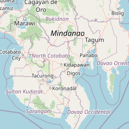
Map view of Agusan Marsh Wildlife Sanctuary

Use this park location map to pinpoint Agusan Marsh Wildlife Sanctuary in Philippines, understand its exact geographic position, and read its mapped placement within the surrounding landscape more clearly.

Pigeon | © OpenStreetMap contributors

Location context for Agusan Marsh Wildlife Sanctuary

Agusan del Sur
Park atlas

Continue comparing surrounding wetland ecosystems, lowland forests, and regional conservation landscapes.

Explore Other Parks Near Agusan Marsh Wildlife Sanctuary And Regional Protected Areas

Visitors exploring Agusan Marsh Wildlife Sanctuary can transition into nearby protected areas and adjacent regional wetland reserves. Comparing connected conservation landscapes provides broader geographic context across Mindanao and surrounding lowland ecosystems.
Nature reserveAgusan del Sur
About 59 km away#1 closest

North

Andanan Watershed Forest Reserve: Protected Landscape and Watershed Geography in Agusan del Sur

Exploring the Diwata Mountains and Andanan River headwaters

Spanning mountainous terrain in Agusan del Sur, the Andanan Watershed Forest Reserve acts as a primary catchment area for the Andanan River system. This nature reserve sustains a mosaic of forest and grassland habitats within the Diwata Mountains, representing a vital node in the regional protected-area network of Mindanao.

Area
150.97 km²
Established
1991
Relief
Mountain
Scope
Terrestrial
Wildlife reserveAgusan del Norte
About 98 km away#2 closest

North

Cabadbaran-Santiago Watershed Forest Reserve: Atlas and Geographic Context

Protected watershed landscapes of the Diwata mountain range

Cabadbaran-Santiago Watershed Forest Reserve serves as a primary forest stronghold in Agusan del Norte. This protected area shields the headwaters of the Cabadbaran and Narog river systems, featuring a diverse topographical mosaic of steep ridges, forested gorges, and montane slopes that define the northern section of the Diwata mountain range.

Area
160.25 km²
Established
1991
Relief
Mountain
Scope
Terrestrial
National parkLanao del Sur
About 136 km away#3 closest

West

Rungkunan National Park: Mapped Protected Landscape and Regional Geography Overview

Discover Rungkunan National Park's protected boundaries and landscape context.

Gain insight into Rungkunan National Park, a protected national park situated in Lanao del Sur. This page details the park's geographic positioning, mapped outlines, and its significance as a conservation landscape. It provides essential context for understanding the distribution of protected areas and the regional geography of the Philippines, facilitating a deeper atlas-style exploration.

Established
1965
IUCN
V
Water
Minor water
National parkLanao del Sur
About 145 km away#4 closest

West

Salikata National Park: Explore Philippines National Park Geography

Mapped protected area boundaries and regional context.

Investigate Salikata National Park, a key protected area designated as a national park within Lanao del Sur, Philippines. This detailed view provides essential context for understanding its mapped boundaries, its place in the regional geography, and its significance as a protected landscape. Discover the unique geographic attributes that define Salikata National Park for atlas-based exploration.

Established
1965
IUCN
V
Relief
Mountain
Climate
Tropical
A watercolor illustration of a mountain range with green, yellow, and soft pink hues, featuring rolling hills and forested slopes in a panoramic format.
National parkPhilippines
About 146 km away#5 closest

Southwest

Mount Apo Natural Park: Volcanic Terrain and Biodiversity in Mindanao, Philippines

Mapping the highest peak and endemic-rich montane ecosystems

Spanning the provinces of Davao del Sur and Cotabato, Mount Apo Natural Park protects the volcanic massif of Mount Apo and its extensive forest surroundings. The park exhibits a distinct altitudinal zonation that supports a significant concentration of endemic birds, mammals, and plant life. Beyond its ecological relevance, the area features dramatic volcanic ridges, cascading waterfalls, and the high-elevation Lake Venado, forming a vital component of the regional natural heritage network in the southern Philippines.

Area
640.53 km²
Established
2004
Relief
Mountain
Climate
Tropical
Protected landscapeSurigao del Norte
About 155 km away#6 closest

North

Mahaba Island Protected Landscape and Seascape: Regional Geography and Island Reserve

A combined coastal and marine protected area in Surigao del Norte.

Spanning both a flat sandy island and its surrounding sea, Mahaba Island Protected Landscape and Seascape illustrates the integrated conservation model of the Philippines. Discover the layered geography of mangrove-fringed shorelines, interior coconut patches, and marine habitats that form this protected reserve in the Caraga region.

Area
57.04 km²
Established
1991
Relief
Lowland
Climate
Tropical
National parkLanao del Sur
About 157 km away#7 closest

West

Lake Butig National Park: National Park Atlas and Geographic Discovery in Lanao del Sur

Discover its mapped boundaries and regional landscape context.

Lake Butig National Park is a protected national park in the Philippines, located within Lanao del Sur. This entry provides specific geographic information and supports atlas exploration by detailing the park's mapped boundaries and its place within the regional landscape. Understand the terrain and protected area context crucial for geographic study and understanding Philippine natural landscapes.

Area
0.68 km²
Established
1965
IUCN
V
Relief
Mountain
National parkLanao del Sur
About 157 km away#8 closest

West

Pantuwaraya Lake National Park: National Park Atlas and Mapped Landscape

Explore the protected area and regional geography of Lanao del Sur.

Understand Pantuwaraya Lake National Park as a defined protected landscape and a significant national park within the Philippines. This entry focuses on its geographic placement in Lanao del Sur, providing context for its mapped boundaries and natural features. Users can explore its representation within a broader atlas of protected lands, gaining insight into its role and landscape identity.

Area
0.2 km²
Established
1965
IUCN
V
Climate
Tropical

Common questions about visiting, size, designation, and location context for Agusan Marsh Wildlife Sanctuary

Agusan Marsh Wildlife Sanctuary FAQs for park facts, access, geography, and protected area context

Find quick answers about Agusan Marsh Wildlife Sanctuary, including protected-area facts, park geography, trail and visitor context, and how the park fits into its surrounding country and regional landscape.
MoriAtlas Explorer

Continue Your Protected Areas Search Across the Global Atlas

Deepen your exploration by continuing the structured search for national parks and protected areas worldwide. Utilize the comprehensive filtering capabilities to compare different conservation landscapes and refine your understanding of global park geography. Discover more about the distribution and characteristics of protected natural areas.

Global natural geography