
Mori Atlas logo
Protected areaAlbuchwiesen

A detailed geographic study of rare mat-grass swards, traditional litter meadows, and clay-lined Hülben pond landscapes.

Albuchwiesen Protected Area: Mapping the Wetland Mosaics of the Eastern Swabian Alb Plateau

(FFH-Gebiet Albuchwiesen)

Albuchwiesen stands as an ecologically distinct protected area on the eastern Swabian Alb plateau, spanning nine individual parcels across the karstic landscape of Baden-Württemberg. This site preserves an intricate mosaic of wetland and grassland habitats, including acidic mat-grass swards, small-sedge wet meadows, and transitional mires that remain vital to the Ostalb region. By mapping these scattered remnants of traditional cultural landscapes, the site highlights the historic relationship between clay-rich soils and the development of unique wetland hollows.

FFH siteNatura 2000meadow protectionwetlandtransitional mireHülben ponds
A flat-style digital illustration of a scenic valley with a winding dirt path in the foreground, a small pond, a lush green meadow, a forest edge, and distant mountain cliffs under a sunny sky with soft clouds.

Albuchwiesen

Protected area

Park overview

Structured park overview, official facts, and landscape profile for Albuchwiesen

Albuchwiesen park facts, protected area profile, and essential visitor context

Review the core facts for Albuchwiesen, including designation, size, terrain, visitor scale, habitats, and operating context in one park-focused overview.

About Albuchwiesen

Albuchwiesen is a protected nature area on the eastern Swabian Alb in the German state of Baden-Württemberg. It lies within the Albuch and Härtsfeld natural landscape and forms part of the network of European Habitats Directive sites (FFH-Gebiete) that safeguard rare and threatened habitat types across the European Union. Although the area encompasses only about 51 hectares, its ecological significance is considerable because it protects a mosaic of habitats that have largely disappeared from the intensively farmed landscape of the Ostalb.

The site comprises nine separate parcels distributed across four municipalities in three counties. The largest share falls within Essingen in the Ostalbkreis, followed by Bartholomä, Böhmenkirch in Landkreis Göppingen, and a tiny portion in Steinheim am Albuch in Landkreis Heidenheim. This fragmented structure reflects the site's origins as a collection of historic land-use features, each linked to specific local ecological conditions such as clay-rich depressions, dry valleys, or the impermeable Tertiary substrates typical of the Swabian Alb plateau.

At the heart of the site lies a network of small still waters, transitional mires, and extensive grassland communities. The still waters and small mires together represent the largest remaining concentration of wetland habitats on the Ostalb outside the Brenz valley, giving the site a regional importance that extends well beyond its modest size. Surrounding these wetland features is a patchwork of mat-grass swards on acidic soils, small-sedge wet meadows, and extensively managed grassland that harbors orchids, calcareous dry grasslands, and specialized woodland types such as ravine and slope mixed forests and orchid-rich beech forests.

Flowing waters with submerged aquatic vegetation, mire and swamp communities, and small areas of heath and scrub complete the habitat mosaic. Embedded within the FFH borders are four formally designated nature reserves: Hülbe am Märtelesberg, Rauhe Wiese, Streuwiese bei Rötenbach, and Weiherwiesen, each protecting particularly valuable cores of the broader complex. About 41 percent of the site also lies within the protected bird area Albuch, linking its habitat conservation with broader efforts to protect the distinctive bird communities of the Swabian Alb plateau.

Quick facts and research context for Albuchwiesen

Albuchwiesen is a European Habitats Directive (FFH) protected area on the eastern Swabian Alb in Baden-Württemberg, Germany. Established by the Regierungspräsidium Stuttgart, the site was officially designated on 11 January 2019 under a regulation issued on 30 October 2018, though the area had been submitted for protection back in 2005. With an area of around 51 hectares, it is the smallest FFH site in Baden-Württemberg.

The site consists of nine separate parcels spread across the municipalities of Essingen, Bartholomä, Böhmenkirch and Steinheim am Albuch, spanning the Ostalbkreis, Landkreis Göppingen and Landkreis Heidenheim. Roughly three-quarters of the area is moist or mesophilic grassland, supported by smaller proportions of wetland, woodland, heath and still water habitats. Several internal nature reserves, including Weiherwiesen, Rauhe Wiese, Streuwiese bei Rötenbach and Hülbe am Märtelesberg, are embedded within the FFH boundaries.

Protection and recognition

Examining documented protected area records and Natura 2000 listings

Albuchwiesen Protection Status and International Recognition Details

Albuchwiesen features documented protection status and official Natura 2000 designations recorded within international conservation databases. Structured records assemble verified designation data to provide clear context for conservation research and protected area analysis.
Park context

Deeper park guide and search-rich context for Albuchwiesen

Albuchwiesen history, landscape, wildlife, and travel context

Explore Albuchwiesen through its history, landscape character, ecosystems, wildlife, conservation priorities, cultural context, and seasonal travel timing in a structured park guide built for atlas discovery and search intent.

Why Albuchwiesen stands out

Albuchwiesen is best known for protecting one of the most concentrated collections of wetland and grassland habitats outside the Brenz valley on the eastern Swabian Alb. The site is especially valued for its still waters and small transitional mires, which together form the bulk of the remaining wetland area on the Ostalb beyond the Brenz river corridor. Equally distinctive are its historical land-use relics: former litter meadows, abandoned woodland pastures, and the characteristic Hülben, small artificial ponds traditionally created by farmers to catch water on impermeable clay layers. These features, together with mat-grass and small-sedge grassland communities, give the site its identity as a refuge of traditional cultural landscapes that have largely vanished from the surrounding region.
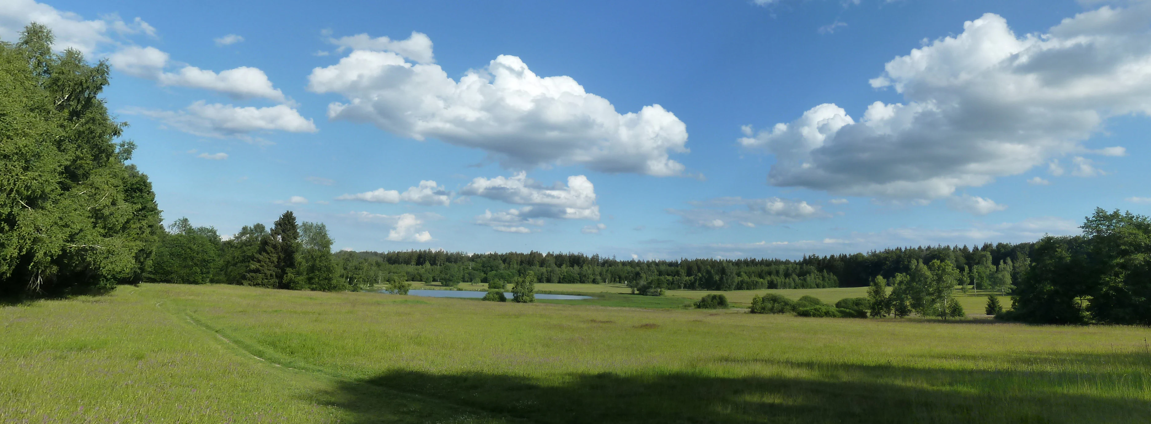
A wide, grassy meadow landscape under a blue sky with scattered clouds, bordered by a line of trees and featuring a small pond in the distance.
A view of the Weiherwiesen meadows in Essingen, part of the Albuchwiesen protected area.

Albuchwiesen history and protected-area timeline

The conservation history of Albuchwiesen begins in 2005, when it was proposed by the Regierungspräsidium Stuttgart as a protected site under the European Habitats Directive. As an FFH site, it forms part of the Natura 2000 network, the European Union's coordinated system of protected areas designed to conserve threatened habitats and species.

For many years the area's ecological value was anchored in its small, formally designated nature reserves, including the Rauhe Wiese, the Streuwiese bei Rötenbach, the Weiherwiesen near Essingen, and the Hülbe am Märtelesberg. These reserves protected the most ecologically sensitive cores of what would later become the larger FFH complex.

The legal foundation for the FFH site itself was established by a regulation issued by the Regierungspräsidium Stuttgart on 30 October 2018, formally defining Albuchwiesen as a site of community importance. This regulation entered into force on 11 January 2019, giving the habitat mosaic its current legal protection. Despite its recent formal designation, the ecological character of the area stretches back much further, reflecting centuries of traditional land use that produced the litter meadows, woodland pastures and Hülben ponds now embedded within the protected landscape.

Albuchwiesen landscape and geographic character

The landscape of Albuchwiesen reflects the geological and cultural character of the eastern Swabian Alb. The area sits on the karstic limestone and clay-rich substrates of the Albuch and Härtsfeld plateau, where impermeable layers have historically created conditions for the formation of ponds, mires and wet meadows. The protected area takes the form of nine scattered parcels, each corresponding to a distinct micro-landscape embedded in the broader plateau terrain.

One of the most visually striking landscape elements is the Hülben, traditional small ponds created by local farmers who lined shallow excavation pits with clay to capture rainwater and provide watering places for livestock on the dry Alb plateau. These ponds, along with more naturally formed still waters, give several of the site parcels a distinctive character of small wetland hollows surrounded by grassland.

The wider terrain includes dry valley hollows, relics of former woodland pastures, and gently sloping grassland on acidic and clay-rich soils. These landforms together create the mosaic of dry and wet micro-habitats that defines the protected area. Although the surrounding region today is largely shaped by modern agriculture and forestry, the protected parcels preserve fragments of the older cultural landscape that once dominated the Ostalb.

Albuchwiesen ecosystems, habitats, and plant life

Albuchwiesen harbors a remarkable diversity of habitat types within an exceptionally small area. A defining theme of the site is the contrast between dry and wet habitats: calcareous dry grasslands and species-rich mat-grass swards on acidic soils exist side by side with moist and mesophilic meadows, still waters and small transitional mires. This juxtaposition is unusual in the modern landscape of the eastern Swabian Alb, where centuries of agricultural intensification have simplified most remaining vegetation.

Roughly three-quarters of the site consists of moist and mesophilic grassland, including extensive wet meadows dominated by small sedges, litter meadows with traditional mowing regimes, and mat-grass swards on acidic substrates. These grasslands support a rich flora, including orchids that thrive in the calcareous dry grassland patches and orchid-rich beech forest fragments. The site's woodlands, though limited in extent, include ecologically valuable types such as ravine and slope mixed forests and orchid-rich beech forests, which are priority habitats under European conservation policy.

The wetland component is particularly significant: still waters with floating and submerged vegetation, transitional mires, and mire-edge vegetation together account for a meaningful share of the protected area. These wetlands represent relics of formerly widespread grassland and mire communities, and they form the largest remaining concentration of wetland habitats on the Ostalb outside the main Brenz valley corridor. Heath and scrub vegetation, as well as small fragments of coniferous and mixed forest, add further structural diversity and ecological value.

Albuchwiesen wildlife and species highlights

Although detailed wildlife inventories for Albuchwiesen are limited in the source material, the combination of habitat types protected by the site directly supports a rich and unusual fauna for the eastern Swabian Alb. The still waters, small transitional mires, and wet meadows provide habitat for amphibians, dragonflies, and aquatic invertebrates that depend on undisturbed small water bodies, many of which have become scarce across the Ostalb due to drainage and agricultural intensification.

The extensive grasslands, including mat-grass swards and calcareous dry grasslands, host a diverse invertebrate fauna typical of traditionally managed meadows, supporting butterfly, moth, and wild bee communities associated with flower-rich, extensively mown or grazed sites. These insects in turn form the prey base for farmland and grassland birds, while the surrounding woodland fragments and scrub offer nesting and sheltering opportunities.

The site's overlap with the Albuch protected bird area, which covers roughly 41 percent of the FFH site, links the habitat protection here to broader efforts to conserve the bird communities of the Swabian Alb plateau. Together with the mosaic of open and semi-open habitats, this makes Albuchwiesen an important refuge for species that depend on the interface between grassland, wetland, and woodland.

Albuchwiesen conservation status and protection priorities

Albuchwiesen was designated as a European Habitats Directive (FFH) site because it protects habitat types that are considered rare, threatened, or representative across the European Union. These include priority habitat types such as orchid-rich beech forests and calcareous dry grasslands, alongside a suite of wetland, mire, grassland, and forest habitats that are regionally significant on the eastern Swabian Alb.

The site's conservation value lies in its role as a refuge for habitats that have largely vanished from the surrounding intensively used agricultural and forestry landscape. In particular, the still waters and small transitional mires within the site account for the majority of remaining wetland habitat on the Ostalb outside the Brenz river valley, making them disproportionately important for regional biodiversity conservation.

The protected area also serves as a structural anchor within the Natura 2000 network, connecting with the Albuch protected bird area and the surrounding network of FFH sites and nature reserves on the Swabian Alb. By safeguarding both the ecological core areas in the embedded nature reserves and the broader habitat mosaic around them, the site supports long-term conservation of grassland, mire, and woodland habitats in a region where such landscapes have become increasingly fragmented.

Albuchwiesen cultural meaning and human context

The landscape of Albuchwiesen is deeply shaped by centuries of traditional land use on the eastern Swabian Alb. The litter meadows that form the backbone of the site are an expression of pre-modern farming practice, in which grass was cut for use as bedding in stables rather than as fresh forage. This traditional use produced the species-rich, nutrient-poor grasslands that today are among the most valuable habitats protected by the site.

Equally rooted in local culture are the Hülben, small artificial ponds that farmers created on the dry Alb plateau by lining shallow pits with clay from impermeable geological layers. These ponds served as watering places for livestock and are a distinctive feature of the regional cultural landscape. Together with the relics of former woodland pastures and the dry valley hollows, these elements give Albuchwiesen its identity as a surviving fragment of the older agricultural landscape of the Ostalb.

Top sights and standout views in Albuchwiesen

Albuchwiesen stands out as a small but exceptionally diverse European Habitats Directive site on the eastern Swabian Alb. Its nine scattered parcels protect a mosaic of acid mat-grass swards, small-sedge wet meadows, traditional litter meadows, calcareous dry grasslands, still waters, and small transitional mires, all within a total area of around 51 hectares. The site is the smallest FFH area in Baden-Württemberg, yet it preserves the largest remaining concentration of wetland habitats on the Ostalb outside the Brenz valley.

Embedded within its boundaries are four formally designated nature reserves, including the Weiherwiesen near Essingen and the Hülbe am Märtelesberg, which protect particularly valuable cores of the broader habitat complex. Roughly 41 percent of the area also overlaps with the Albuch protected bird area, linking the site's grassland, wetland, and woodland conservation to broader efforts to safeguard the natural heritage of the Swabian Alb plateau.

Best time to visit Albuchwiesen

Albuchwiesen is primarily a habitat-protection site rather than a visitor destination, so seasonal access and the experience of the landscape depend heavily on local conditions. Late spring and early summer are typically the most rewarding periods for viewing the species-rich grasslands and orchids in flower, while the still waters and small mires are most visible and ecologically active during wetter parts of the year when water levels in the Hülben and other ponds are highest.

Traditional litter meadows are usually managed through late summer or autumn mowing, and visiting after the cut can reveal the open, well-structured grassland mosaic that characterizes the site. Winter months, by contrast, may offer clearer views of the underlying landscape structure, with the ponds, dry valley hollows, and woodland fragments standing out in the bare landscape. Visitors should always respect local access restrictions in the protected nature reserves embedded within the site.

Monthly climate preview

Examine measured monthly temperature swings and precipitation patterns across the year at Albuchwiesen

Albuchwiesen Climate Normals, Long-Term Temperature and Precipitation Records

Representative coordinate records show average monthly temperatures ranging from sub-zero winter minimums to warm summer maximums alongside steady daily precipitation amounts. Reviewing the complete twelve-month climatology dataset clarifies long-term meteorological trends and annual thermal rhythms across Albuchwiesen.
Annual mean9 °C
-1 °C18 °C
Jan-1°
Feb
Mar
Apr
May13°
Jun16°
Jul18°
Aug18°
Sep14°
Oct
Nov
Dec
Warmest month
July

18.4 °C

Coolest month
January

-1 °C

Wettest month
July

3 mm/day

Driest month
April

1.6 mm/day

Park location guide

Geography guide, regional context, and park location map for Albuchwiesen

Albuchwiesen park geography, regions, and map view in Germany

Understand where Albuchwiesen sits in Germany through a broader geographic reading of the surrounding landscape, nearby location context, and its mapped position within the national park landscape.

How Albuchwiesen fits into Germany

Germany is a federal republic in Western and Central Europe with a population of over 83 million across sixteen constituent states. It is Europe's largest economy by nominal GDP and a major global exporter and importer. The capital is Berlin, and the country borders Denmark, Poland, Czech Republic, Austria, Switzerland, France, Luxembourg, Belgium, and the Netherlands.

Wider geography shaping Albuchwiesen in Germany

Germany is located in Western and Central Europe, spanning 357,022 km². It borders Denmark to the north, Poland and the Czech Republic to the east, Austria and Switzerland to the south, and France, Luxembourg, Belgium, and the Netherlands to the west. The country has coastlines on the Baltic Sea and North Sea to the north, with the Alps located in the southern region.

Map view of Albuchwiesen

Use this park location map to pinpoint Albuchwiesen in Germany, understand its exact geographic position, and read its mapped placement within the surrounding landscape more clearly.

Pigeon | © OpenStreetMap contributors

Location context for Albuchwiesen

Baden-Württemberg
Recorded earthquake history

View the Historical Earthquake Catalogue for the Albuchwiesen Protected Area

Continue your exploration of Albuchwiesen geography by reviewing our compiled earthquake history. This database offers a detailed look at past seismic events in the region, providing verifiable records of epicentres and magnitudes as archived by MoriAtlas for those interested in local geological context.

Albuchwiesen Earthquake History

Catalogued events

7 events

Strongest magnitude

Magnitude 4.3

Most recent event

Aug 1, 1999

This history includes earthquakes recorded inside the park or within 50 km of its borders

Explore visual records of regional wetland mosaics, traditional ponds, and protected terrain.

Albuchwiesen Photos and Landscape Scenery: Visualizing Protected Habitats

Visual documentation reveals the distinctive terrain and wetland habitats preserved across the scattered parcels of Albuchwiesen. Examining protected area photography helps clarify the rare grassland mosaics, traditional ponds, and ecological features defining the Swabian Alb.

A wide, grassy meadow landscape under a blue sky with scattered clouds, bordered by a line of trees and featuring a small pond in the distance.

Park atlas

Compare regional plateau landscapes and connected wetland reserves across the Ostalb

Other Parks and Protected Areas Near Albuchwiesen on the Swabian Alb

Browsing other parks near Albuchwiesen reveals the wider distribution of protected wetland and grassland habitats across the eastern Swabian Alb plateau. Extending the exploration helps compare similar cultural landscapes and regional conservation areas beyond the immediate municipal parcels.
Faint watercolor illustration of rolling green hills and a pinkish foreground against a white background.
Protected areaBaden-Württemberg
3 km away#1 closest

West

Albtrauf Donzdorf-Heubach: Protected Escarpments and Karst Terrain in the Swabian Alb

Natura 2000 protected area in eastern Baden-Württemberg

The Albtrauf Donzdorf-Heubach site comprises eight protected parcels along the Swabian Alb. Its geography is defined by steep limestone cliffs, dissected valleys, and extensive karst systems that support specialized biodiversity. This protected landscape highlights the complex interaction between Upper Jurassic geological formations and traditional land-use patterns across the Göppingen and Ostalbkreis districts.

Area
25.333 km²
Established
2019
Relief
Highland
Climate
Temperate
Protected landscapeBaden-Württemberg
About 5.4 km away#2 closest

Southeast

Ur-Brenztal Protected Landscape: Geography and River Valley Mapping in Baden-Württemberg

Wetland meadow corridors and ancestral drainage relics

Ur-Brenztal stands as a vital protected landscape in the Landkreis Heidenheim, serving as a rare open grassland passage. The area preserves flat valley floors and low-energy stream channels that provide essential stepping stone habitats for migratory birds and meadow-nesting populations between regional high plateaus.

Area
0.69 km²
Established
2003
IUCN
V
Relief
Lowland
A pale, horizontal watercolor illustration depicting rolling green hills, scattered trees, and a forested horizon line on a white background.
Protected areaBaden-Württemberg
7.8 km away#3 closest

South

Hungerbrunnen-, Sacken- und Lonetal Protected Area: Geography and Landscape Atlas

Karst limestone valleys and juniper heath corridors

This protected area showcases the unique hydrology and geology of the eastern Swabian Alb. The landscape is defined by its dramatic transition from plateau to valley floor, featuring intermittent stream beds, limestone rocky outcrops, and high-value beech forest ecosystems that form a vital part of the local Natura 2000 network.

Area
9.179 km²
Established
2005
Relief
Upland
Climate
Temperate
Protected landscapeBaden-Württemberg
About 9.5 km away#4 closest

Southeast

Weidmichele, Eichelesäcker und anschließender Talgrund Protected Landscape Atlas

Geographic analysis of Swabian Alb dry valley terrain

Examine the topographical profile of Weidmichele, Eichelesäcker und anschließender Talgrund. This landscape protection area showcases the classic karst dry valley form found in Baden-Württemberg, providing a vital, narrow grassland corridor between upland plateaus and the lower Brenz valley ecosystem.

Area
0.153 km²
Established
1978
IUCN
V
Protected landscapeBaden-Württemberg
About 19 km away#5 closest

Southwest

Weigoldsberg Protected Landscape: Mapped Terrain in the Swabian Alb of Baden-Württemberg

A contiguous hill-landscape with integrated Natura 2000 ecological zones

Weigoldsberg functions as a coherent protected landscape unit within the Mittlere Kuppenalb, spanning the transition between upland terrain and the Fils valley. This area integrates near-natural forest, traditional meadow mosaics, and high-value ecological zones such as the Filsalb FFH and Mittlere Schwäbische Alb bird protection area. Gain insights into its relief, land use patterns, and conservation designation.

Area
2.16 km²
Established
1975
IUCN
V
Relief
Mountain
A watercolor painting showing a soft, impressionistic landscape with green hills, forested ridgelines in the distance, and pink wildflowers in the foreground.
Protected landscapeBaden-Württemberg
About 20 km away#6 closest

South

Mittleres Lonetal Protected Landscape: Swabian Alb Geography and Mapping

A regional protected area within the Alb-Donau-Kreis district

Mittleres Lonetal represents a key protected landscape in Baden-Württemberg, following the linear path of the Lone valley. The area integrates diverse terrain, including broadleaf forest, juniper heaths, and moisture-rich meadow dales, offering a comprehensive look at the rural geography and conservation zoning typical of the Swabian Alb region.

Area
31.581 km²
Established
1989
IUCN
V
Protected landscapeAlb-Donau-Kreis
About 20 km away#7 closest

South

Westerstetten Protected Landscape: Mapping the Swabian Alb Karst and Valley Terrain

Protected landscape geography within the Alb-Donau-Kreis region

The Westerstetten protected landscape preserves a layered mosaic of karst plateaus, juniper heath, and dry side valleys in the northern Swabian Alb. This region serves as a connective buffer for local ecosystems, featuring extensive woodland blocks and traditional field hedges that represent the historic character of the Alb-Donau-Kreis countryside.

Area
5.834 km²
Established
1998
IUCN
V
Relief
Upland
A horizontal watercolor painting depicting a soft-focus landscape with green fields, patches of trees, and rolling hills in the background under a pale sky.
Protected landscapeBaden-Wuerttemberg
About 25 km away#8 closest

Southwest

Nellingen Protected Landscape: Mapping the Cultural and Karstic Terrain of Central Swabia

Protected landscape geography and regional land use

Nellingen Protected Landscape encompasses over 1,500 hectares of the Swabian Alb, forming an essential link in the regional conservation network. This site provides insight into the karstic landforms of the Kuppenalb, including sinkholes and dry valleys, while preserving a living history of agricultural practices such as orchard management and sheep grazing. This analysis provides a structured overview of the area topography and its significance in the regional landscape context.

Area
15.212 km²
Established
1999
IUCN
V
Relief
Upland

Common questions about visiting, size, designation, and location context for Albuchwiesen

Albuchwiesen FAQs for park facts, access, geography, and protected area context

Find quick answers about Albuchwiesen, including protected-area facts, park geography, trail and visitor context, and how the park fits into its surrounding country and regional landscape.
MoriAtlas Explorer

Continue Your Protected Areas Search Across the Global Atlas

Deepen your exploration by continuing the structured search for national parks and protected areas worldwide. Utilize the comprehensive filtering capabilities to compare different conservation landscapes and refine your understanding of global park geography. Discover more about the distribution and characteristics of protected natural areas.

Global natural geography