Mori Atlas logo
Nature reserveAltes Schleifer Teichgelände

A diverse mosaic of wet heath, orchid-rich meadows, and historic pond systems in Eastern Germany

Altes Schleifer Teichgelände Nature Reserve: Mapping the Protected Landscapes of Sachsen

(Naturschutzgebiet Altes Schleifer Teichgelände)

Located in the Saxon district of Görlitz, Altes Schleifer Teichgelände serves as a critical nature reserve within the Muskauer Heide. This protected area features a complex mosaic of birch mire forests, fens, and connected fishponds linked by the Struga stream. The site illustrates a notable recovery of wetland habitats and rare meadow ecosystems following decades of industrial and agricultural influence near the Trebendorf plateau.

wetlandnature reservepond landscapeMuskau HeathUpper Lusatiawet heath

Altes Schleifer Teichgelände

Nature reserve

Park overview

Structured park overview, official facts, and landscape profile for Altes Schleifer Teichgelände

Altes Schleifer Teichgelände park facts, protected area profile, and essential visitor context

Review the core facts for Altes Schleifer Teichgelände, including designation, size, terrain, visitor scale, habitats, and operating context in one park-focused overview.

About Altes Schleifer Teichgelände

Altes Schleifer Teichgelände is a compact but ecologically significant nature reserve in Upper Lusatia, in the far east of Saxony. Although small in size, it embodies many of the regional landscape elements that give the Muskauer Heide its identity: dry and wet heath fragments, deciduous and mixed woodland, species-rich meadows, and a network of ponds fed by the small Struga stream.

The protected area lies between Schleife and Trebendorf, at the foot of the higher ground that forms the Trebendorf plateau. Its setting is quietly distinctive rather than dramatic, shaped by glacial and post-glacial processes typical of the larger Muskau push moraine region. Visitors walking the established nature trail encounter a sequence of habitats that shift rapidly over short distances, from open wet grassland through reed beds and ponds into birch-dominated mire forest and dry grassy ridges.

The reserve's interest is heightened by its cultural and historical layering. Forest clearance, traditional fishpond management, centuries of agricultural use, and twentieth-century lignite mining all left visible marks on the landscape. Since the end of the intensive mining era and improvements in water quality, the site has progressively returned to a more natural ecological balance. Today it functions as both a refuge for protected species and an accessible outdoor site, where its 2006 nature trail provides a structured way to experience these recovering habitats.

Quick facts and research context for Altes Schleifer Teichgelände

Altes Schleifer Teichgelände is a Saxon nature reserve (Naturschutzgebiet) with the official designation D 85, located in the municipality of Schleife within the Landkreis Görlitz. The reserve covers around 67 hectares and forms part of the natural region known as the Muskauer Heide.

The site has been protected since 1981 and was designated as a Natura 2000 FFH area in 2002 under the code DE-4453-301. The FFH zone overlaps with but does not fully match the boundaries of the nature reserve, although the two share a common core area. The reserve lies near the Cottbus–Görlitz railway line, at the foot of the Trebendorf plateau, with the Struga stream running through it.

Protection and recognition

Documented terrestrial protection history and official Natura 2000 recognition data

Altes Schleifer Teichgelande Protection Status and Designation Records

Altes Schleifer Teichgelande maintains documented terrestrial protection status established in 2002 alongside official Natura 2000 recognition records. Structured conservation data details the designation history and formal protection scope associated with this protected area.

International recognition

Protection details

Protection scope
Terrestrial
Designated year
2002
Transboundary protection
No
WDPA ID
162123
Park context

Deeper park guide and search-rich context for Altes Schleifer Teichgelände

Altes Schleifer Teichgelände history, landscape, wildlife, and travel context

Explore Altes Schleifer Teichgelände through its history, landscape character, ecosystems, wildlife, conservation priorities, cultural context, and seasonal travel timing in a structured park guide built for atlas discovery and search intent.

Why Altes Schleifer Teichgelände stands out

The reserve is best known for its combination of wet heath, fen, and orchid-rich meadows set within a small but ecologically rich mosaic of woodland and old fishponds. Pond habitats such as the Großteich and the Studźonkteich, along with the surrounding bell-heath bogs and birch mire forest, give the area its distinctive character within the broader Muskauer Heide. It is also notable for the recovery of its plant and animal communities following decades of pressure from agricultural melioration, industrial pollution entering the Struga, and nearby lignite mining. The presence of protected habitat types such as Glockenheidefeuchtheiden, Moorbirkenwald, and Flachlandmähwiesen makes it a recognized reference site for heathland and damp meadow conservation in Upper Lusatia.
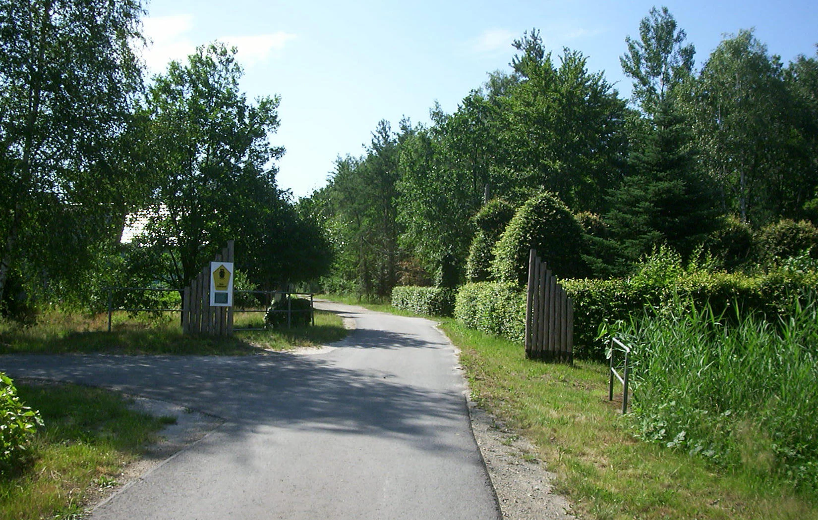
A paved path leads through a park entrance marked by two wooden posts and a nature reserve sign, bordered by trees and dense green vegetation.
Northeast entrance to the Altes Schleifer Teichgelände nature reserve.

Altes Schleifer Teichgelände history and protected-area timeline

The area now protected as Altes Schleifer Teichgelände has been used by local communities since at least the thirteenth century. Forests in the vicinity supported beekeeping and timber harvesting, while cleared zones were turned into meadows for haymaking and pasture. The ponds that remain a defining feature of the reserve, including the Großteich, the smaller Teich, and the Studźonkteich, originated as fish farming ponds set within the surrounding wetland.

The cultural memory of the landscape was shaped by Johann Hano-Hantscho, who recorded much of the Schleife region's folklore and traditions. Many of his stories are set in the Großteich area, and place-name evidence has been linked to the wetland character of the terrain. The local Sorbian name for Schleife, Slepo, has been interpreted as deriving from a descriptive word for the soft, murmuring sound one makes while walking across the waterlogged meadows.

Industrial pressures arrived in the second half of the nineteenth century. Mining began affecting the area from 1867 with the Grube Gustav-Adolf workings, and intensified from 1962 to 1969 under the Trebendorfer Felder opencast mine. From 1969 onward the larger Nochten opencast mine, located nearby, continued to shape the wider hydrology and environmental conditions. Combined with widespread agricultural drainage and the discharge of industrial effluents into the Struga, these pressures degraded the site through the late twentieth century.

Against this backdrop, the Großteich and Kleinteich were declared a nature reserve in the summer of 1981, marking a decisive shift toward protective management. The political changes around 1989 brought further improvements: water quality in the Struga recovered as polluting discharges ended, and the broader landscape began regenerating. In 2002 the area was integrated into the European Natura 2000 network as an FFH site, extending its significance beyond Saxony. A nature trail was added in 2006, formalizing public access for educational and recreational use.

Altes Schleifer Teichgelände landscape and geographic character

The reserve occupies the lower slopes and basin edge at the foot of the Trebendorf plateau, within the broader context of the Muskauer Heide natural region. The terrain is largely flat to gently undulating, shaped by the geological legacy of the Muskau push moraine and shaped further by water movement and centuries of land use.

Water is a defining element of the landscape. The Struga stream threads through the reserve, connecting a series of pond basins, including the Großteich, the smaller Teich, and the Studźonkteich. Surrounding these open water bodies are wet meadows, reed and sedge stands, damp heath patches, and small pockets of mire woodland. The result is a finely textured mosaic where pond margins, marshy grassland, and wet heath shift into one another over short distances.

Dry, sun-exposed grassy ridges and clearings provide contrast to the wetter zones, supporting a different set of plants and insects. Mixed deciduous and coniferous woodland frames much of the reserve and adds structural variety to the scenery. The nearby Cottbus–Görlitz railway line and the wider forest cover of the Muskau heath beyond the reserve frame the site as a transitional landscape, where small-scale ecological features are embedded within a much larger forested region.

Altes Schleifer Teichgelände ecosystems, habitats, and plant life

Ecologically, Altes Schleifer Teichgelände is a compact mosaic of habitats characteristic of the Upper Lusatian heath and pond landscape. Its protected habitat types include bell-heath wet heaths, moor birch woodland, lowland hay meadows, species-rich wet meadows that function as orchid meadows, dry grasslands, naturally maintained ditches, and reed and sedge beds. The variety within such a small area is one of the reserve's defining strengths.

The vegetation reflects this habitat diversity. Open wet zones support marsh marigold, common buttercup, water crowfoot, frogbit, water plantain, narrow-leaved pondweed, marsh violet, marsh iris, and the striking glistening sword lily. Heath and acidic grassland areas carry bell heather, heather, devil's-bit scabious, and pipe grass, along with characteristic meadow species such as quaking grass, great burnet, and wood anemone. In the wooded fringes, herb-rich ground vegetation includes lesser celandine, lungwort, and woodland masterwort.

Several protected plant species of regional importance occur here, including the blue columbine, the spotted orchid, the cassubian vetch, Phrygian cornflower, and the greater butterfly orchid. The combination of orchid-rich meadows and heath communities elevates the site above the typical ecological value of comparable small reserves in the region.

Altes Schleifer Teichgelände wildlife and species highlights

The reserve supports a broad spectrum of fauna, shaped by the close interplay of woodland, water, meadow, and heath habitats. Wetland and reed habitats are particularly important for birds. White storks, cranes, gray geese, mallards, and great reed warblers use the ponds and reed fringes, while larger raptors such as the white-tailed eagle, red kite, and common buzzard hunt over the area. Woodpeckers including the black woodpecker and green woodpecker are characteristic of the mixed woodland.

In the surrounding forests and forest edges, red deer and fallow deer are present, along with small mammals typical of Lusatian woodland mosaics. Wetland amphibians are well represented, with natterjack toad, common toad, moor frog, common frog, and garlic toad recorded in the damp meadows and pond margins. Night-active species such as the tawny owl are also part of the reserve's animal community.

Insect life is rich, partly because of the unimproved meadows and heaths. Notable butterflies include the scarce large blue, the scarce large blue's relative Dusky Large Blue species group, and other meadow specialists. Dragonflies such as mosaic hawkers and various emerald and small red-eyed damselflies are characteristic of the ponds and ditches. The presence of these insect groups is significant both ecologically and as a food resource for the reserve's bats and birds.

Altes Schleifer Teichgelände conservation status and protection priorities

Altes Schleifer Teichgelände has clear value for habitat and species conservation in Upper Lusatia. As a Saxon nature reserve, its primary role is the active protection and management of vulnerable habitat types and species. Its IUCN-aligned management purpose emphasizes habitat and species conservation, including interventions such as maintaining open water bodies, managing meadow cutting regimes to sustain orchid populations, and protecting the integrity of wet heath and birch mire woodland.

Its inclusion in the Natura 2000 network since 2002 strengthens this role at the European level. Designation as an FFH site obliges authorities to maintain favorable conservation status for the listed habitat types, including lowland hay meadows, wet heath, and mire woodland, and for protected species. The overlapping but not identical boundaries of the nature reserve and the FFH zone mean that the most ecologically sensitive core area receives the highest level of protection, while the broader Natura 2000 zone buffers the reserve against external pressures.

The reserve's conservation importance is also historical: it represents a partial ecological recovery story, where degraded ponds, polluted streams, and drained meadows have been progressively restored following the 1989 political changes and the closure of polluting industrial operations. Today, it functions as a small but effective stronghold for heathland and meadow biodiversity within the much larger Oberlausitzer Heide- und Teichlandschaft biosphere reserve region.

Altes Schleifer Teichgelände cultural meaning and human context

The reserve reflects the deep entanglement of natural landscape and regional culture in the Sorbian-influenced part of Upper Lusatia. Place names, folklore, and traditional land uses are woven into the wetland itself. The Sorbian name for the nearby town, Slepo, has been etymologically associated with the soft, murmuring sound one hears while walking across the wet meadows, suggesting that local cultural memory has long recognized the site's distinctive character.

The figure of Johann Hano-Hantscho stands out as a key cultural link. He documented much of the Schleife region's folklore, and many of his stories are set in the Großteich area. His writings remain an important source for understanding how local people experienced and narrated the surrounding landscape over more than a century.

Traditional land uses including beekeeping, timber harvesting, haymaking, and pond-based fish farming have shaped both the visible landscape and the ecological character of the site. These cultural layers coexist with the more recent industrial imprint of nineteenth- and twentieth-century lignite mining, making the reserve a place where medieval land use, folk tradition, industrial heritage, and modern ecological conservation overlap.

Top sights and standout views in Altes Schleifer Teichgelände

A small but habitat-rich Saxon nature reserve where wet heath, orchid-rich meadows, and old fishponds meet within the broader Muskau heath landscape.

Protected since 1981, designated as an FFH site in 2002, and now recovering steadily from past agricultural drainage, mining impacts, and industrial pollution. Its mosaic of ponds, marshy meadows, birch mire woodland, and dry grassland pockets supports rare plant species including blue columbine and spotted orchids, alongside notable insects, amphibians, and wetland birds. A 2006 nature trail makes these recovering habitats accessible for careful exploration.

Best time to visit Altes Schleifer Teichgelände

Late spring and early summer are particularly rewarding, when the wet meadows bring orchid-rich displays and the ponds and reed fringes host active amphibian and insect life. Early summer also offers the chance to see wetland birds and dragonflies in their busiest period along the Struga and across the pond basins.

Late summer and early autumn bring their own character, with bell heather and other heath plants in flower and meadow species setting seed, which in turn supports insect-rich conditions. Cool, clear days in this period often make the trails more comfortable for walking. Visitors interested in wintering birds and a quieter atmosphere may also find the colder months appealing, when the open water and surrounding heath structure become easier to observe in low light.

Because the reserve is managed primarily for ecological protection rather than visitor services, any visit should be planned with light, respectful use of the marked nature trail and an awareness of sensitive meadow and heath zones.


Monthly climate preview

Long-term representative point measurements of monthly temperature and precipitation for Sachsen

Altes Schleifer Teichgelände Climate Normals and Annual Temperature Rhythm

Representative coordinate records show average monthly temperatures ranging from sub-zero winter minimums to warm summer maximums alongside steady daily precipitation amounts. Detailed monthly climate normals provide a complete picture of the long-term meteorological rhythm across the protected landscape.
Annual mean9 °C
-1 °C20 °C
Jan-1°
Feb
Mar
Apr
May14°
Jun18°
Jul20°
Aug20°
Sep15°
Oct
Nov
Dec
Warmest month
July

20.4 °C

Coolest month
January

-1.1 °C

Wettest month
July

2.7 mm/day

Driest month
April

1.2 mm/day

Park location guide

Geography guide, regional context, and park location map for Altes Schleifer Teichgelände

Altes Schleifer Teichgelände park geography, regions, and map view in Germany

Understand where Altes Schleifer Teichgelände sits in Germany through a broader geographic reading of the surrounding landscape, nearby location context, and its mapped position within the national park landscape.

How Altes Schleifer Teichgelände fits into Germany

Germany is a federal republic in Western and Central Europe with a population of over 83 million across sixteen constituent states. It is Europe's largest economy by nominal GDP and a major global exporter and importer. The capital is Berlin, and the country borders Denmark, Poland, Czech Republic, Austria, Switzerland, France, Luxembourg, Belgium, and the Netherlands.

Wider geography shaping Altes Schleifer Teichgelände in Germany

Germany is located in Western and Central Europe, spanning 357,022 km². It borders Denmark to the north, Poland and the Czech Republic to the east, Austria and Switzerland to the south, and France, Luxembourg, Belgium, and the Netherlands to the west. The country has coastlines on the Baltic Sea and North Sea to the north, with the Alps located in the southern region.

Map view of Altes Schleifer Teichgelände

Use this park location map to pinpoint Altes Schleifer Teichgelände in Germany, understand its exact geographic position, and read its mapped placement within the surrounding landscape more clearly.

Pigeon | © OpenStreetMap contributors

Location context for Altes Schleifer Teichgelände

Sachsen
Recorded earthquake history

Review Historical Earthquake Records for Altes Schleifer Teichgelände

Examine the historical catalogue of seismic events recorded in the vicinity of Altes Schleifer Teichgelände. MoriAtlas provides a clear view of location-based earthquake data, allowing for deeper engagement with the regional geographic context and history of this protected nature reserve in Sachsen.

Altes Schleifer Teichgelände Earthquake History

Catalogued events

3 events

Strongest magnitude

Magnitude 3.7

Most recent event

Aug 13, 2008

This history includes earthquakes recorded inside the park or within 50 km of its borders

Visual exploration of the protected reserve, pond networks, and wetland habitats

Altes Schleifer Teichgelände Photos and Landscape Scenery

Visual documentation captures the varied terrain, wet heath communities, and old fishponds that define the protected environment of Altes Schleifer Teichgelände. Detailed imagery reveals the mosaic of damp meadows, birch mire forests, and winding stream corridors across the landscape.

A paved path leads through a park entrance marked by two wooden posts and a nature reserve sign, bordered by trees and dense green vegetation.

Park atlas

Compare adjacent wetland reserves and regional habitats across Upper Lusatia

Parks Near Altes Schleifer Teichgelände and Surrounding Protected Landscapes

Discover other protected areas near Altes Schleifer Teichgelände to examine similar regional wetland habitats and lowland pond networks. Comparing adjacent Saxon reserves expands your geographic understanding of the wider Muskau heath ecosystem.
Protected areaSaxony
1.2 km away#1 closest

Southeast

Trebendorfer Tiergarten: Protected Woodland and Natura 2000 Habitat in Saxony

Mapped forest terrain in the Landkreis Görlitz

Trebendorfer Tiergarten encompasses approximately 201 hectares of inland forest, reflecting the habitat conservation priorities of the European Union. Located in eastern Saxony, the reserve features clearly defined boundaries shaped by historic infrastructure and forestry, offering a precise case study of protected land within the wider Lusatian heath and pond landscape.

Area
2.01 km²
Established
1961
Relief
Lowland
Climate
Temperate
Watercolor painting of a lake surrounded by green trees and soft rolling hills in the background on a white background.
Nature reserveSaxony
About 7.6 km away#2 closest

Southeast

Braunsteich Nature Reserve: Mapped Geography and Protected Wetland Boundaries

Examining the ecological terrain of the Saxony lake district.

Braunsteich represents a protected confluence of open water and southern mire within the Lusatian lowlands. This nature reserve serves as a prime example of glacially shaped landscape management in Saxony, featuring distinct pine forest margins and historic water control infrastructure that remain visible today.

Area
0.44 km²
Established
1400
Relief
Lowland
Access
Easy access
Nature reserveBrandenburg
About 10 km away#3 closest

Northeast

Zschornoer Wald Nature Reserve: Regional Geography and Protected Landscape Analysis

A Lusatian forest protected area within the Spree-Neisse district.

Zschornoer Wald represents a notable example of post-Cold War land reclamation in Brandenburg, Germany. This 628 hectare nature reserve serves as an ecological anchor near the Lausitzer Neisse river, providing vital forest habitat management. By mapping its unique origins as a former bombing range alongside its current conservation role, this atlas entry provides a comprehensive look at the reserve's physical geography, human-altered terrain, and its position within the broader Spree-Neisse landscape.

Area
6.28 km²
Established
2002
IUCN
IV
Relief
Lowland
Nature reserveSaxony
About 11 km away#4 closest

East

Hammerlugk Nature Reserve: Mapped Protected Wetlands and Mosaic Landscapes in Saxony

A rare surviving remnant of the historic Upper Lusatian moorland ecosystem.

Spanning 74 hectares, Hammerlugk stands as a crucial nature reserve in Saxony, characterized by its swampy woodland and wet meadow mosaic. This protected area serves as an important ecological anchor within the Muskauer Heide, preserving wetland habitats that have largely vanished elsewhere due to lignite mining and regional drainage. The reserve provides a quiet, low-lying sanctuary that remains vital for understanding the original natural terrain of the Upper Lusatian heath country.

Area
0.74 km²
Established
1996
Relief
Lowland
Climate
Temperate
A pale, soft watercolor painting of a serene moorland landscape with rolling green hills and a light, misty background.
Nature reserveSaxony
25 km away#5 closest

Southwest

Dubringer Moor Nature Reserve: Geographic Atlas and Protected Landscape Mapping

Extensive mire and wetland complex in the Saxony region

Spanning over 1,700 hectares, Dubringer Moor serves as a prime example of a through-flow moor system with deep peat deposits. The reserve features a unique integration of old fish-pond culture, open heath-mire, and coniferous forest, all situated within a glacial landscape that anchors the wetland ecology of northern Saxony. Examine the boundaries and environmental context of this significant habitat.

Area
17.11 km²
Established
1995
IUCN
IV
Relief
Lowland
Nature reserveBrandenburg
29 km away#6 closest

Northwest

Koselmühlenfließ Nature Reserve: A Protected Stream Valley in the Brandenburg Region

Geographic overview of the Lusatian land ridge brook habitat

Koselmühlenfließ protects a largely natural lowland stream and its floodplain corridor set amidst the undulating landscapes of the Lusatian land ridge. This nature reserve in the Spree-Neisse district represents a focused contribution to the Brandenburg conservation network, highlighting the value of small-scale brook environments in northeast Germany.

Area
1.12 km²
Established
2006
IUCN
IV
Relief
Lowland
Nature reserveBautzen
30 km away#7 closest

South

Spreeniederung Malschwitz Nature Reserve and Riverine Floodplain Geography

Protected riparian landscapes in the Bautzen district

Spreeniederung Malschwitz represents a significant protected floodplain along the Spree river. This nature reserve provides crucial habitats through its complex network of traditional fishponds, oxbow lakes, and old-growth forests, serving as a key staging site for migratory waterfowl within the Upper Lusatian landscape.

Area
18.57 km²
Established
2002
Nature reserveBrandenburg
About 33 km away#8 closest

West

Sorno-Rosendorfer-Buchten Nature Reserve: Geographic Overview and Protected Landscape Maps

Lusatian lake district protected area and post-mining restoration terrain.

This nature reserve in Brandenburg provides a deep look at the ecological evolution of post-industrial land. The area features a mix of flooded mining pits, sheltered bays, and nutrient-poor sandy soils that support pioneering plant communities and remnant forest patches. Explore the mapped boundaries and the specific geographic context of this unique German protected landscape.

Area
10.9 km²
Established
2014
IUCN
IV

Common questions about visiting, size, designation, and location context for Altes Schleifer Teichgelände

Altes Schleifer Teichgelände FAQs for park facts, access, geography, and protected area context

Find quick answers about Altes Schleifer Teichgelände, including protected-area facts, park geography, trail and visitor context, and how the park fits into its surrounding country and regional landscape.
MoriAtlas Explorer

Continue Your Protected Areas Search Across the Global Atlas

Deepen your exploration by continuing the structured search for national parks and protected areas worldwide. Utilize the comprehensive filtering capabilities to compare different conservation landscapes and refine your understanding of global park geography. Discover more about the distribution and characteristics of protected natural areas.

Global natural geography