
Mori Atlas logo
Nature reserveAltneckarlachen von Alsbach, Hähnlein und Bickenbach

A preserved mosaic of ancient river meanders, swamp forests, and wet meadows in the Hessian Ried

Altneckarlachen von Alsbach, Hähnlein und Bickenbach Nature Reserve and Wetland Landscapes

(Naturschutzgebiet „Altneckarlachen von Alsbach, Hähnlein und Bickenbach“)

The Altneckarlachen von Alsbach, Hähnlein und Bickenbach nature reserve encompasses a complex network of silted-up prehistoric river loops situated within the flat Hessian Rhine plain. This protected area features a diverse wetland mosaic including reed-fringed shallow water, black-alder swamp forest, and low-moor peatland. It serves as a vital refuge for breeding waterbirds and diverse insect populations, reflecting the natural character of the historic Neckar course.

wetlandnature reserveformer river loopslow moorreed bedsswamp forest
Stylized digital illustration of a valley between steep cliffs with waterfalls and a winding river framed by trees and marsh vegetation.

Altneckarlachen von Alsbach, Hähnlein und Bickenbach

Nature reserve

Park overview

Structured park overview, official facts, and landscape profile for Altneckarlachen von Alsbach, Hähnlein und Bickenbach

Altneckarlachen von Alsbach, Hähnlein und Bickenbach park facts, protected area profile, and essential visitor context

Review the core facts for Altneckarlachen von Alsbach, Hähnlein und Bickenbach, including designation, size, terrain, visitor scale, habitats, and operating context in one park-focused overview.

About Altneckarlachen von Alsbach, Hähnlein und Bickenbach

The Altneckarlachen von Alsbach, Hähnlein und Bickenbach lies west of Bickenbach and north of Hähnlein in the Rhine plain of southern Hesse. It belongs to the natural region known as the Hessische Rheinebene, more specifically the sub-unit called the Mittleres Neckarried, where the landscape still carries the traces of an older, much larger river system that once flowed between the Rhine and the western slopes of the Odenwald. Today the reserve forms a string of small waterbodies, damp depressions, reed stands, and wet woodland that together illustrate the geomorphological history of the Altneckar, the former course of the Neckar before it shifted roughly two thousand years ago to its present valley.

The site encompasses four floodplain ponds: the Waldlache and Schächerlache, which are dominated by extensive reed belts, and the Hainlache and Fasanenlache, where black-alder swamp forest, extensively grazed grassland, and reed communities form a closely interwoven mosaic. The neighbouring Weilerhügel provides a small elevation contrast and adds visible structure above the otherwise flat Rhine plain. To the northeast, the A5 motorway forms a hard boundary, while the broader landscape still functions as part of the wider Hessian Ried wetland system.

The reserve's ecological character depends critically on groundwater. Long-term groundwater extraction in the Ried lowered water tables, causing the peaty soils to compact and settle to today's elevation of roughly 90 metres above sea level. Conservation managers have responded by restoring wet conditions, notably through a wind-powered pumping station that has maintained a shallow-water zone and an advancing reed belt in the Schächerlache and Waldlache since the mid-1990s. These interventions have stabilised habitat for waterbirds, amphibians, fish, bats, and an exceptionally diverse community of larger moths, making the Altneckarlachen an important reference site for wetland conservation in the Hessian lowlands.

Quick facts and research context for Altneckarlachen von Alsbach, Hähnlein und Bickenbach

The Altneckarlachen von Alsbach, Hähnlein und Bickenbach is a 89.24-hectare nature reserve in the Landkreis Darmstadt-Dieburg, southern Hesse, lying within the natural region of the Hessische Rheinebene at the Mittleres Neckarried. It was legally protected on 28 August 1990 and is part of the EU Birds Directive site Hessische Altneckarschlingen (site code 6217-403). The reserve lies on former loops of the Altneckar, a prehistoric course of the Neckar between the Rhine and the western uplands, and incorporates the Waldlache, Fasanenlache, Schächerlache, and Hainlache waterbodies along with the Weilerhügel hills. The surface elevation today sits between about 90.0 and 90.6 metres above sea level, lowered by historical peat shrinkage following groundwater extraction.

Protection and recognition

Documented terrestrial protection history and designation records

Altneckarlachen von Alsbach, Hähnlein und Bickenbach Protection Status

Altneckarlachen von Alsbach, Hähnlein und Bickenbach maintains a formal terrestrial protection status established in 1990 under recorded management parameters. Official designation records outline the historical framework of this protected landscape without additional international listings.

Protection details

Protection scope
Terrestrial
Designated year
1990
Transboundary protection
No
WDPA ID
162129
Park context

Deeper park guide and search-rich context for Altneckarlachen von Alsbach, Hähnlein und Bickenbach

Altneckarlachen von Alsbach, Hähnlein und Bickenbach history, landscape, wildlife, and travel context

Explore Altneckarlachen von Alsbach, Hähnlein und Bickenbach through its history, landscape character, ecosystems, wildlife, conservation priorities, cultural context, and seasonal travel timing in a structured park guide built for atlas discovery and search intent.

Why Altneckarlachen von Alsbach, Hähnlein und Bickenbach stands out

The reserve is best known for preserving a representative stretch of silted-up prehistoric Neckar meanders, the Altneckarschlingen, in the culturally significant Hessian Ried. Its combination of low-moor peatland, reed-fringed shallow water, black-alder swamp forest, and traditionally grazed wet meadows forms a distinctive wetland mosaic in an otherwise heavily drained agricultural landscape. It is also notable as a bird refuge, where rare breeding species such as the Bluethroat, Little Grebe, Water Rail, and Marsh Harrier continue to nest in actively managed wet habitat, and where 275 species of larger moths have been documented, including several threatened taxa.
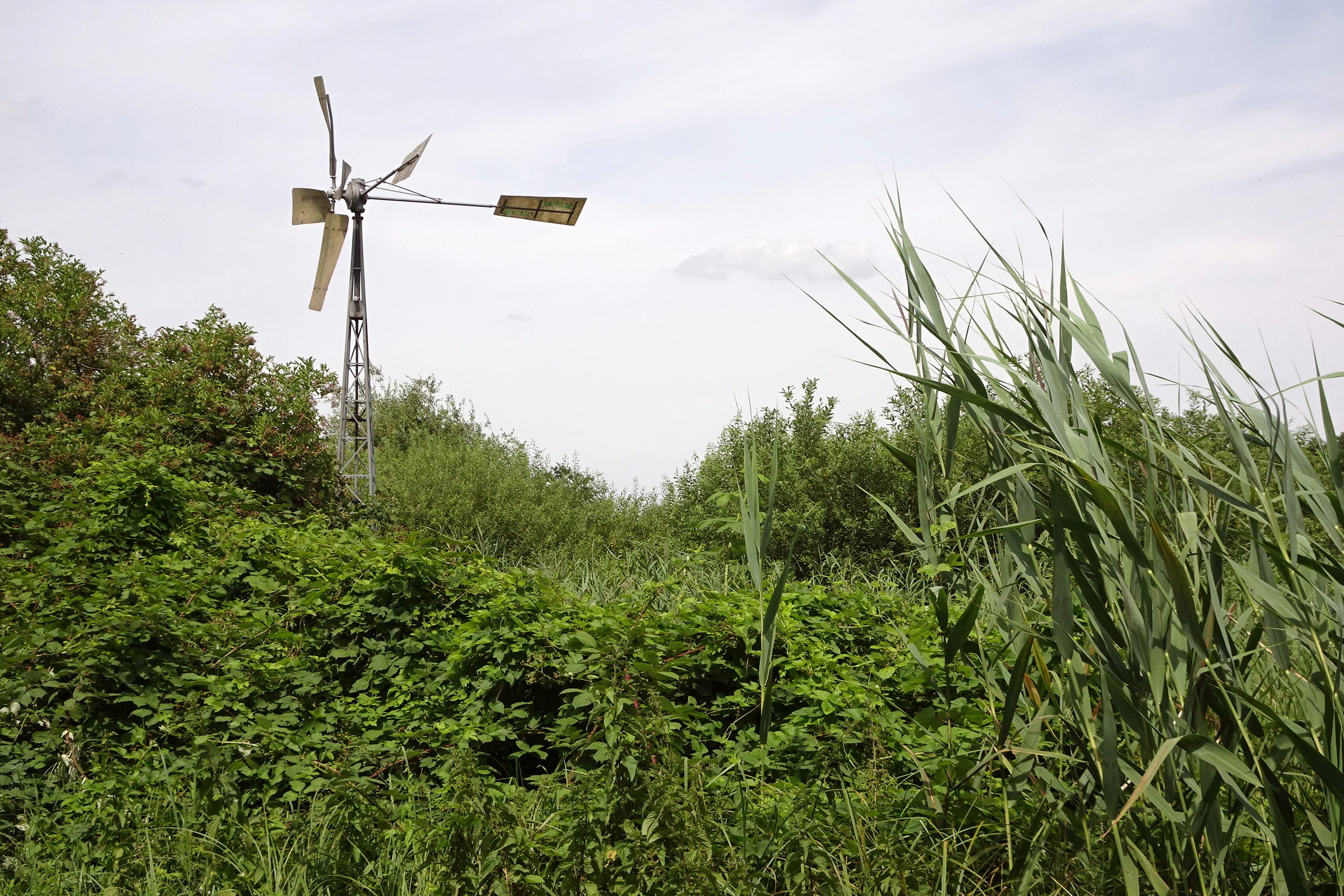
A vintage metal wind pump stands amidst lush green wetland vegetation including tall reeds and dense shrubs under an overcast sky.
A wind pump situated in the Waldlache wetland area within the Altneckarlachen nature reserve.

Altneckarlachen von Alsbach, Hähnlein und Bickenbach history and protected-area timeline

The Altneckarlachen as a recognisable landscape is ancient, shaped by the prehistoric course of the Neckar, whose former loops were gradually cut off and filled with sediment as the river shifted toward its present valley around two millennia ago. The accumulated loam, clay, and peat deposits in these abandoned channels created the wet soils and peatlands that characterise the reserve today.

In the modern era, the site was long part of the intensively used agricultural and forestry landscape of the Hessian Ried. Groundwater extraction for settlements, industry, and agriculture during the second half of the twentieth century lowered the water table and led to compaction of the peat, lowering the surface by several decimetres. By the late 1980s, the ecological value of the silted-up meanders had become sufficiently clear to justify formal protection.

The area was officially designated as the Naturschutzgebiet Altneckarlachen von Alsbach, Hähnlein und Bickenbach by Hessian regulation on 28 August 1990. In 1995, a wind-powered pumping station was installed at the Waldlache and Schächerlache to maintain shallow-water conditions, and the reserve was later integrated into the EU Birds Directive site Hessische Altneckarschlingen, anchoring its role in regional bird conservation policy.

Altneckarlachen von Alsbach, Hähnlein und Bickenbach landscape and geographic character

The landscape of the Altneckarlachen is a low-lying wetland mosaic set within the otherwise flat Hessian Rhine plain. The reserve sits on peatland and mineral wetland soils at elevations only slightly above 90 metres, giving it an almost imperceptible relief broken mainly by the low rise of the Weilerhügel. The defining elements of the scenery are the elongated, partly silted-up waterbodies of the Waldlache, Schächerlache, Fasanenlache, and Hainlache, which trace the curved outlines of former river bends. Reed belts, open shallow water, black-alder swamp forest, and extensively grazed damp meadows alternate across short distances, while narrow ditches and the Landgraben connect different parts of the system. The A5 motorway cuts along the northeast edge, otherwise the surrounding fields of the Hessisches Ried enclose the protected area as a green island in a heavily cultivated plain.
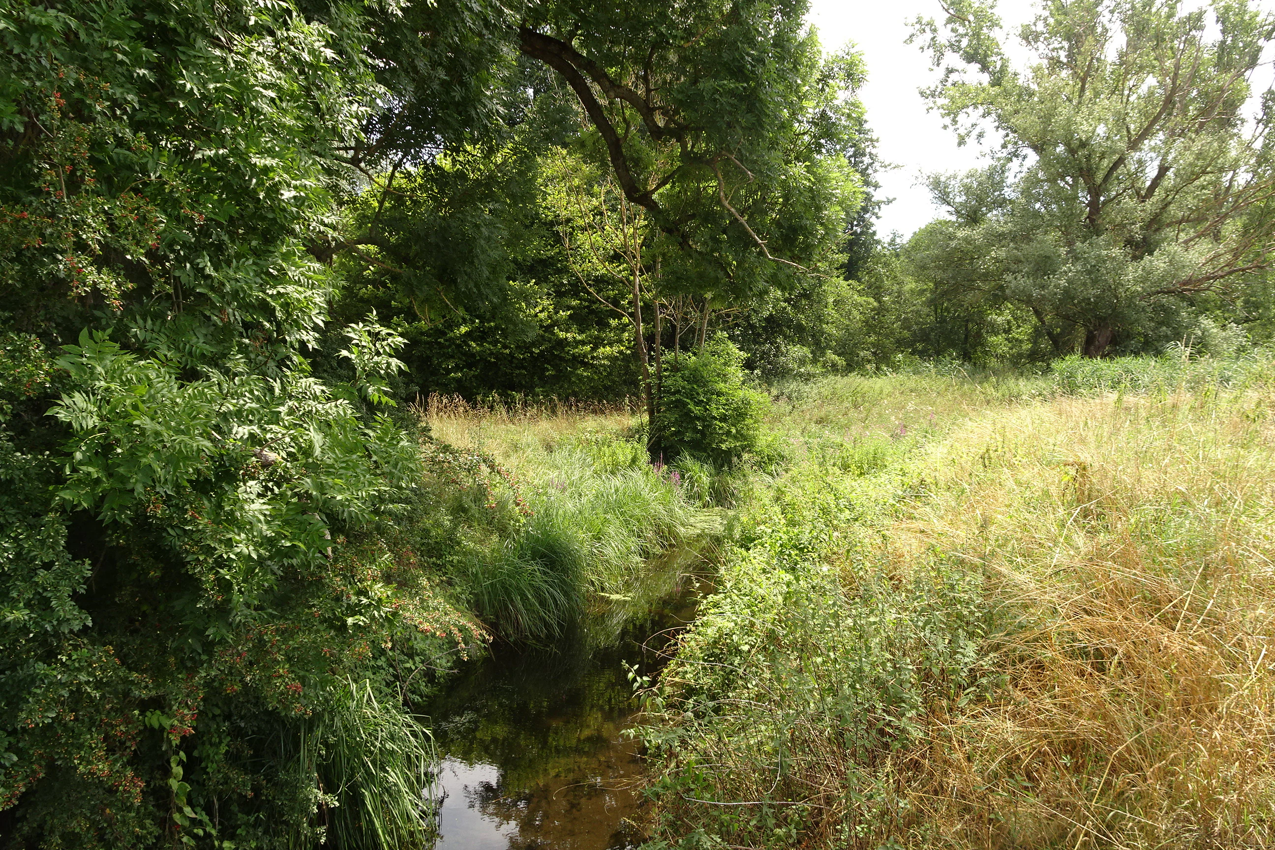
A small narrow stream runs through a lush green wetland area with dense trees and tall grasses on either side.
A narrow stream flowing through the wetland habitat of the Altneckarlachen nature reserve.

Altneckarlachen von Alsbach, Hähnlein und Bickenbach ecosystems, habitats, and plant life

Ecologically, the reserve is dominated by wetland habitats developed on low-moor peat soils that continue to be influenced by the strongly fluctuating groundwater of the Hessian Ried. Reed communities, particularly in the Schächerlache and Waldlache, form the core of the aquatic vegetation, while the Hainlache and Fasanenlache support extensive black-alder swamp forest (Bruchwald) interspersed with reed stands and traditionally grazed wet grassland.

Through active rewetting, managers have created persistent shallow-water zones bordered by a gradually expanding reed belt, enabling a succession of reed habitats from open water to drier grassland. Elsewhere, low-intensity cattle grazing maintains open meadow character and prevents dominance by shrubs or reeds. The combination of permanent and seasonal wet conditions, peat soils, and varied vegetation structure gives the area particular ecological importance within the otherwise heavily drained Rhine plain.
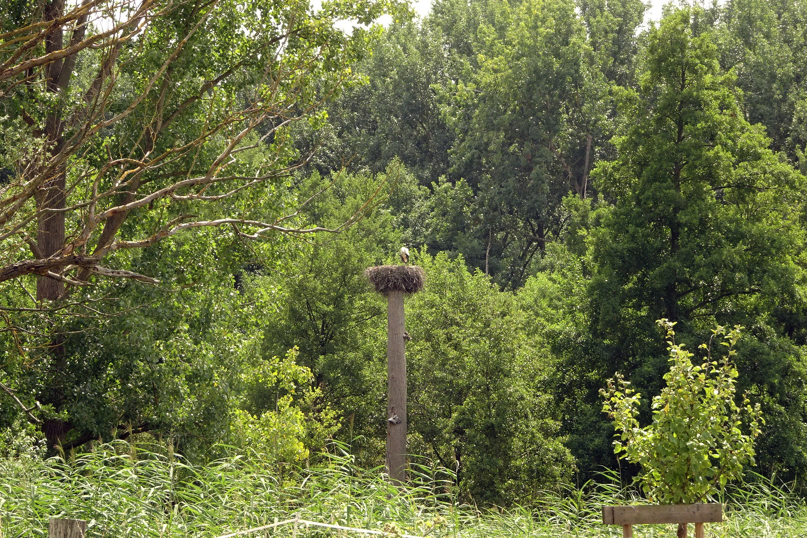
A white stork nest sits on a tall wooden pole in a green, wooded area. Tall green trees surround the pole and dense foliage fills the background.
A white stork nest perched atop a pole within the wooded wetland habitat of the Altneckarlachen nature reserve.

Altneckarlachen von Alsbach, Hähnlein und Bickenbach wildlife and species highlights

The reserve is widely recognised as an important bird habitat, supporting a mix of breeding waterbirds and reedbed species. Little Grebes, Bluethroats, Water Rails, and Marsh Harriers are recorded as regular breeders in the reed-fringed waterbodies, while Little Bitterns, Great Reed Warblers, and Sedge Warblers appear more occasionally. In wetter years, Garganey and Whinchat have also nested in the area, though breeding success at Hainlache and Fasanenlache declined as conditions dried, prompting renewed rewetting efforts in 2017. A White Stork nest at the Fasanenlache visible from the surrounding woodland adds another distinctive element.

Beyond birds, the wetland supports amphibians such as water frogs, smooth newts, and natterjack toads, plus fish populations that include three-spined sticklebacks in the ditches and wet channels. Bats are also present, with species such as the common noctule recorded hunting above the wet forest and waterbodies. A particularly notable faunal feature is the moth fauna: 275 species of larger Lepidoptera have been documented, including a significant share that are rare or considered threatened in the regional context.
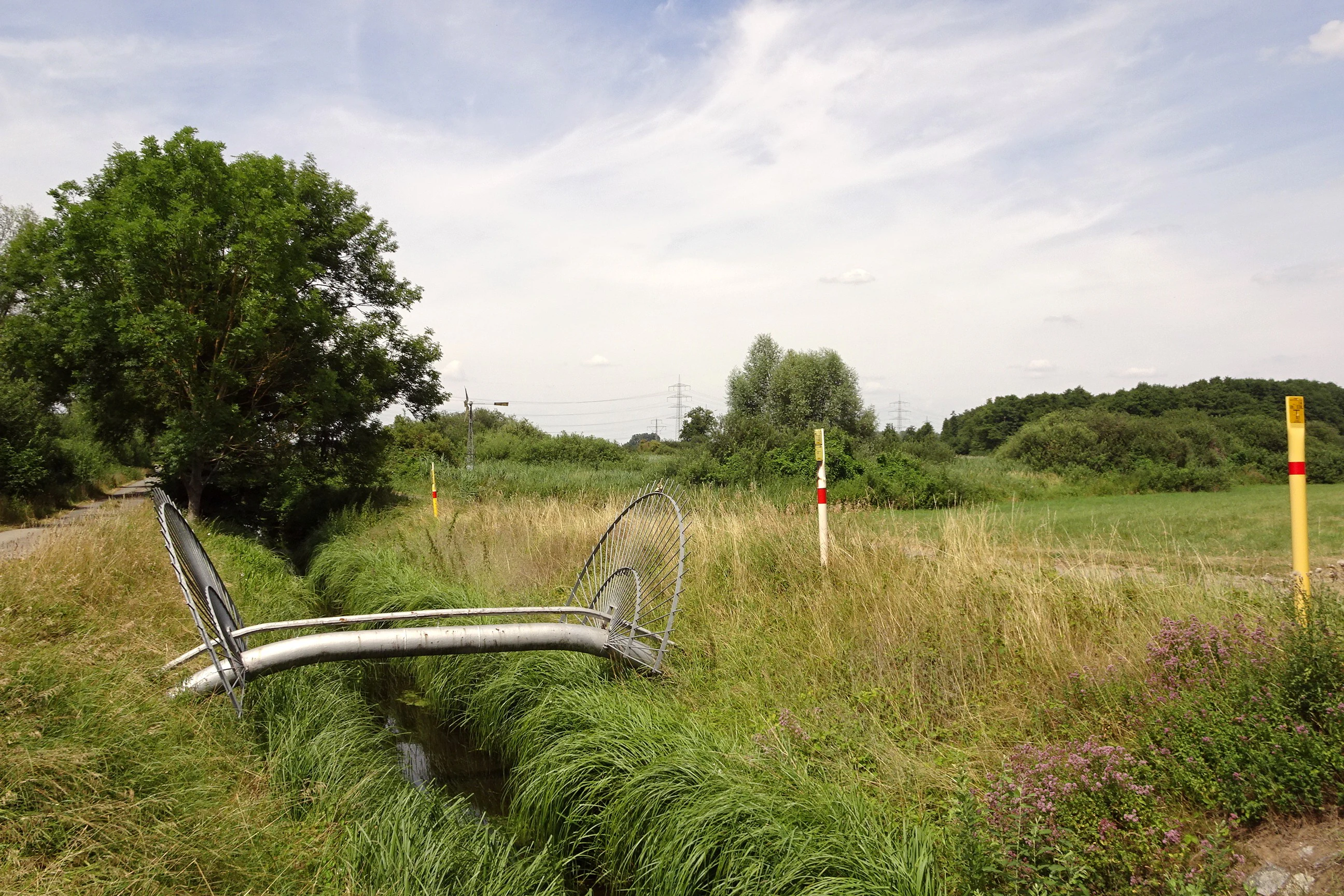
A landscape view of a rural nature reserve with a small drainage ditch in the foreground, yellow pipeline markers, and distant trees under a partly cloudy sky.
A view across the Landgraben towards the Waldlache area, featuring pipeline marker signage in the Altneckarlachen nature reserve.

Altneckarlachen von Alsbach, Hähnlein und Bickenbach conservation status and protection priorities

The Altneckarlachen is classified as an IUCN Category IV Habitat and Species Management Area, indicating that conservation focuses on maintaining and actively managing specific habitats and species assemblages rather than allowing purely natural processes to dominate. Its principal conservation aim is to secure a representative section of silted-up Altneckar river loops together with the rare plant communities and hydrological conditions on which they depend.

Management has emphasised the extensification of agricultural use, the conversion of former arable or improved grassland into permanent wet meadow, and the active improvement of the Bruchwald through selective interventions. Since 1995, a wind-driven pumping station has helped maintain the hydrology of the Waldlache and Schächerlache, while recommendations in 2017 extended similar rewetting to the Hainlache and Fasanenlache to safeguard sensitive breeding bird populations. Integration into the EU Birds Directive site Hessische Altneckarschlingen (6217-403) underlines the area's importance at the European scale for waterbird and reedbed conservation.

Altneckarlachen von Alsbach, Hähnlein und Bickenbach cultural meaning and human context

The Altneckarlachen belongs to a wider cultural landscape of the Hessisches Ried, where villages such as Alsbach, Hähnlein, and Bickenbach have shaped centuries of interaction with lowland floodplain soils through grazing, haymaking, peat cutting, and small-scale water management. The gentle topography of the Weilerhügel and the toponyms referring to former river bends preserve traces of this long human relationship with a dynamic river landscape.

The labour-intensive character of the older regional economy, with portable wooden windmills used to pump water, is echoed today by the wind-powered Schöpfwerk in the reserve, an updated version of traditional water-management technology. A roughly six-kilometre Biotoptour laid out by the Landkreis Darmstadt-Dieburg invites visitors to experience the area from a conservation-education perspective, connecting local heritage with present-day ecological management.

Top sights and standout views in Altneckarlachen von Alsbach, Hähnlein und Bickenbach

A protected slice of prehistoric Neckar meanders in the Hessische Rheinebene, the Altneckarlachen brings together reed-fringed shallow water, low-moor peatland, black-alder swamp forest, and grazed wet meadow in a single compact reserve. Its combination of active rewetting by a historic-style wind pumping station, formal nature protection since 1990, and inclusion in the larger EU Birds Directive site Hessische Altneckarschlingen makes it a regional reference point for wetland conservation in the densely populated Rhine-Main area.

The reserve's outstanding features include regular breeding populations of Bluethroat and Marsh Harrier, the documented presence of Little Bittern and White Stork, an unusually rich moth fauna with many rare species, and a cultural-geological storyline that links today's small ponds and ditches directly to a vanished river that once drained the Odenwald into the proto-Rhine.

Best time to visit Altneckarlachen von Alsbach, Hähnlein und Bickenbach

The reserve is most rewarding in spring and early summer, when reed-bed birds such as Bluethroat, Reed Warbler, and Marsh Harrier are establishing territories and when the shallow-water zones reached by the Schöpfwerk are at their fullest. Late spring also optimises chances to observe amphibians near the ditches and wet meadow edges.

In late summer and early autumn, the mix of reed, water, and grazed meadow continues to attract diverse insects, including many of the larger moth species for which the site is notable. Winter brings quieter conditions and the possibility of seeing waterfowl concentrating on the unfrozen sections of the ponds, while the flat terrain demands weather-appropriate clothing at any season, since the open Rhine plain offers little shelter.

Monthly climate preview

Long-term temperature and precipitation patterns across representative coordinates in Hessen

Climate Normals and Annual Temperature Range in Altneckarlachen von Alsbach, Hähnlein und Bickenbach

Altneckarlachen von Alsbach, Hähnlein und Bickenbach exhibits measured long-term temperature ranges from sub-freezing winter minimums to warm summer maximums alongside steady daily precipitation normals. Reviewing the complete monthly profile provides deeper insight into historical weather variations and multi-year meteorological averages across the protected terrain.
Annual mean10 °C
0 °C21 °C
Jan
Feb
Mar
Apr10°
May14°
Jun18°
Jul21°
Aug20°
Sep15°
Oct10°
Nov
Dec
Warmest month
July

20.6 °C

Coolest month
January

0.2 °C

Wettest month
July

2.2 mm/day

Driest month
April

1.4 mm/day

Park location guide

Geography guide, regional context, and park location map for Altneckarlachen von Alsbach, Hähnlein und Bickenbach

Altneckarlachen von Alsbach, Hähnlein und Bickenbach park geography, regions, and map view in Germany

Understand where Altneckarlachen von Alsbach, Hähnlein und Bickenbach sits in Germany through a broader geographic reading of the surrounding landscape, nearby location context, and its mapped position within the national park landscape.

How Altneckarlachen von Alsbach, Hähnlein und Bickenbach fits into Germany

Germany is a federal republic in Western and Central Europe with a population of over 83 million across sixteen constituent states. It is Europe's largest economy by nominal GDP and a major global exporter and importer. The capital is Berlin, and the country borders Denmark, Poland, Czech Republic, Austria, Switzerland, France, Luxembourg, Belgium, and the Netherlands.

Wider geography shaping Altneckarlachen von Alsbach, Hähnlein und Bickenbach in Germany

Germany is located in Western and Central Europe, spanning 357,022 km². It borders Denmark to the north, Poland and the Czech Republic to the east, Austria and Switzerland to the south, and France, Luxembourg, Belgium, and the Netherlands to the west. The country has coastlines on the Baltic Sea and North Sea to the north, with the Alps located in the southern region.

Map view of Altneckarlachen von Alsbach, Hähnlein und Bickenbach

Use this park location map to pinpoint Altneckarlachen von Alsbach, Hähnlein und Bickenbach in Germany, understand its exact geographic position, and read its mapped placement within the surrounding landscape more clearly.

Pigeon | © OpenStreetMap contributors

Location context for Altneckarlachen von Alsbach, Hähnlein und Bickenbach

Hessen

Examine the wetland mosaic, former river loops, and distinct environmental character of the reserve through detailed photography.

Visualizing Altneckarlachen von Alsbach, Hähnlein und Bickenbach: Landscapes, Habitats, and Protected Scenery

Visual records capture the low-moor peatland, reed beds, and shallow water zones that define the terrain of Altneckarlachen von Alsbach, Hähnlein und Bickenbach. Examining these protected habitats provides deeper insight into the ecological structure and wetland geography of the Hessian plain.

A vintage metal wind pump stands amidst lush green wetland vegetation including tall reeds and dense shrubs under an overcast sky.

A wide view of a green meadow bordered by dense hedgerows and trees, with a triangular nature reserve sign visible on the right.

A small narrow stream runs through a lush green wetland area with dense trees and tall grasses on either side.

A white stork nest sits on a tall wooden pole in a green, wooded area. Tall green trees surround the pole and dense foliage fills the background.

A landscape view of a rural nature reserve with a small drainage ditch in the foreground, yellow pipeline markers, and distant trees under a partly cloudy sky.

Park atlas

Discover adjacent protected landscapes and regional wetland reserves in the Hessian Rhine plain

Explore Parks Near Altneckarlachen von Alsbach, Hähnlein und Bickenbach

Compare Altneckarlachen von Alsbach, Hähnlein und Bickenbach with other protected areas across the surrounding region. Regional park browsing reveals connected wetland habitats and distinct lowland geography.
A watercolor painting showing a soft, stylized landscape of green meadows, sparse trees, and distant rolling hills against a white background.
Nature reserveHesse
About 0.8 km away#1 closest

Southeast

Im Dulbaum bei Alsbach Nature Reserve: Mapped Inland Dunes and Grassland Geography

A vital protected sandy terrain in the Hessian Rhine Plain

Im Dulbaum bei Alsbach protects a remnant of the historic Rhine graben sand dune belt in southern Hesse. This nature reserve provides essential habitat connectivity for heat-loving species through its distinct calcareous sand grasslands and former quarry terrain, offering a look into the region's complex ecological history.

Area
0.092 km²
Established
1994
IUCN
IV
Relief
Lowland
A watercolor landscape illustration showing a winding stream, marsh grasses, and trees with soft rolling hills in the background, set against a pale background.
Nature reserveHessen
About 2.5 km away#2 closest

Northeast

Pfungstädter Moor Nature Reserve: Hessian Wetland and Ancient River Landscape

Protected wetland area in the Hessian Rhine plain

This nature reserve encompasses a rare silted-up segment of the ancient Neckar river, forming a complex of reed beds, alder carr, and peat bog habitats. Managed through creative restoration techniques that lift Rhine water into the moor, the landscape remains a vital ecological sanctuary in the heart of Hesse, standing in sharp contrast to the surrounding agricultural terrain.

Area
0.97 km²
Established
1955
IUCN
IV
Relief
Lowland
A soft watercolor painting of a rolling green hillside with trees, set against a pale, light-colored background.
Nature reserveHessen
About 4.4 km away#3 closest

Southeast

Orbishöhe von Auerbach und Zwingenberg: Geography, Landscape, and Protected Area Mapping

An examination of Hessian quarry-based ecological conservation sites.

The Orbishöhe von Auerbach und Zwingenberg nature reserve serves as a prime example of localized conservation within the Odenwald hills. Its landscape is defined by former quarry faces and open slope terraces, which provide a critical habitat for rare and threatened plant species. This resource offers a clear look at the reserve's topography, physical boundaries, and its broader role within the Natura 2000 network of protected German lands.

Area
0.064 km²
Established
1988
A horizontal watercolor painting showing a soft, impressionistic landscape with rolling hills, sparse trees, and pale green and pink tones on a white background.
Nature reserveHesse
About 5.3 km away#4 closest

Northeast

Kalksandkiefernwald bei Bickenbach, Pfungstadt und Seeheim-Jugenheim Protected Area Atlas

A rare calcareous sand pine forest in the Hessian Rhine plain

Located in the Darmstadt-Dieburg district, this reserve protects an airy, light-filled woodland on calcareous sandy ground. The terrain is defined by its gentle undulations and historical woodland grazing traces, offering a unique look at forest management in the Rhine plain. Explore the distribution of its two distinct sections, including the specialized sand grass vegetation found along its managed utility corridors.

Area
0.874 km²
Established
1996
IUCN
IV
Relief
Lowland
A horizontal watercolor illustration of a soft, hazy landscape featuring light pink blooming trees in a green field, with rolling, misty purple and brown hills in the background.
Nature reserveHesse
About 6.8 km away#5 closest

East

Fuchswiese bei Stettbach: Mapped Nature Reserve and Protected Meadow Landscape in Hesse

Exploring the ecological boundaries of a specialized wet meadow reserve in southern Hesse

Fuchswiese bei Stettbach is a dedicated nature reserve serving as a critical habitat for threatened meadow butterfly species. Located in the Darmstadt-Dieburg district of Hesse, this protected area preserves wet meadow vegetation amidst the northern Odenwald fringe. The site offers a focused view into how small, carefully managed landscapes contribute to the broader ecological health and regional geography of central Germany.

Area
0.03 km²
Established
2010
Watercolor painting showing a stylized, panoramic landscape of rolling hills and forest, depicted in soft green and earth tones against a white background.
Nature reserveHessen
About 7.5 km away#6 closest

East

Felsberg bei Reichenbach Nature Reserve: Geography and Granite Boulder Field Analysis

Protected forest and geological monument in the Odenwald range

Felsberg bei Reichenbach protects 168 hectares of Odenwald mountain slope in Southern Hessen. The site is centered on the Felsenmeer, a dramatic sea of granite boulders created by frost weathering, framed by mixed deciduous woodland. This area functions as an important Natura 2000 habitat, preserving both specialized rock ecosystems and montane forest, providing a clear geographic link between the Lautertal valley and the high slopes of the Felsberg summit.

Area
1.677 km²
Established
1972
IUCN
IV
Relief
Mountain
A pale, soft-toned watercolor painting showing rolling green and golden dunes under a light, hazy sky.
Nature reserveHessen
About 7.6 km away#7 closest

Northeast

Düne am Ulvenberg von Darmstadt-Eberstadt: Inland Sand Dune Protected Area Geography

A rare Pleistocene dune ecosystem in the Hessen region.

Düne am Ulvenberg von Darmstadt-Eberstadt represents a critical inland dune fragment within the Upper Rhine Graben. This nature reserve provides essential habitat for sand-dwelling flora in a setting defined by its open, dry sandy flats, pine woodland, and specialized steppe-like turf that persists as a unique geological legacy.

Area
0.089 km²
Established
1991
IUCN
IV
A watercolor painting of a pastoral landscape with soft green meadows, scattered trees, and distant purplish hills under a white sky.
Nature reserveHessen
About 7.6 km away#8 closest

Southeast

Magerrasen von Gronau mit angrenzenden Flächen Protected Landscape and Regional Geography

A network of calcareous meadows in the Odenwald foothills

Located in the Bergstraße district of Hessen, this protected area spans three distinct sub-areas characterized by nutrient-poor calcareous soils. These warm, sun-exposed meadows serve as an essential refugium for orchid diversity and specialized butterfly populations, standing as a representative example of successfully managed dry grassland ecosystems within the broader Geo-Naturpark Bergstraße-Odenwald.

Area
1.6 km²
Established
2004

Common questions about visiting, size, designation, and location context for Altneckarlachen von Alsbach, Hähnlein und Bickenbach

Altneckarlachen von Alsbach, Hähnlein und Bickenbach FAQs for park facts, access, geography, and protected area context

Find quick answers about Altneckarlachen von Alsbach, Hähnlein und Bickenbach, including protected-area facts, park geography, trail and visitor context, and how the park fits into its surrounding country and regional landscape.
MoriAtlas Explorer

Continue Your Protected Areas Search Across the Global Atlas

Deepen your exploration by continuing the structured search for national parks and protected areas worldwide. Utilize the comprehensive filtering capabilities to compare different conservation landscapes and refine your understanding of global park geography. Discover more about the distribution and characteristics of protected natural areas.

Global natural geography