Mori Atlas logo
Wildlife reserveAnaimalai Tiger Reserve

Mapping the protected boundaries and natural terrain of this key wildlife reserve.

Anaimalai Tiger Reserve: India's Protected Landscape and Wildlife Reserve Geography

Anaimalai Tiger Reserve stands as a vital protected area within India's diverse geography. This wildlife reserve offers a unique landscape for atlas exploration, focusing on its mapped boundaries and the regional context of its natural terrain. Understanding Anaimalai Tiger Reserve provides critical insight into India's conservation efforts and the geographic distribution of its significant protected lands.

tiger reserveWestern Ghatstropical forestwildlife conservationelephant habitatmountain forest

Anaimalai Tiger Reserve

Wildlife reserve

Park overview

Structured park overview, official facts, and landscape profile for Anaimalai Tiger Reserve

Anaimalai Tiger Reserve park facts, protected area profile, and essential visitor context

Review the core facts for Anaimalai Tiger Reserve, including designation, size, terrain, visitor scale, habitats, and operating context in one park-focused overview.

About Anaimalai Tiger Reserve

Anaimalai Tiger Reserve is situated in the Anaimalai Hills, a mountainous region in the southern part of the Western Ghats in Tamil Nadu, India. The Western Ghats are recognized globally as a biodiversity hotspot due to their extraordinary concentration of endemic species and diverse habitat types. The reserve protects forest ecosystems that range from wet evergreen forests in the valleys to shola grasslands at higher elevations. This gradient creates diverse ecological niches supporting a wide variety of flora and fauna. The reserve's location within the Anaimalai Hills places it in a critical position for maintaining ecological connectivity between different forest patches in the region, supporting wildlife movement and genetic exchange between populations.

Quick facts and research context for Anaimalai Tiger Reserve

Anaimalai Tiger Reserve is located in the Anaimalai Hills of the Western Ghats mountain system in Tamil Nadu, southern India. The reserve protects tropical and subtropical forest habitats within a mountainous landscape characterized by steep slopes, valleys, and evergreen forest corridors. It forms part of a larger network of protected areas in the Western Ghats that preserve the region's extraordinary plant and animal diversity. The reserve is recognized as an Important Tiger Conservation Area and contributes to India's tiger protection initiatives under Project Tiger.

Park context

Deeper park guide and search-rich context for Anaimalai Tiger Reserve

Anaimalai Tiger Reserve history, landscape, wildlife, and travel context

Explore Anaimalai Tiger Reserve through its history, landscape character, ecosystems, wildlife, conservation priorities, cultural context, and seasonal travel timing in a structured park guide built for atlas discovery and search intent.

Why Anaimalai Tiger Reserve stands out

Anaimalai Tiger Reserve is best known as a tiger and elephant habitat within the Western Ghats, one of the world's eight biodiversity hotspots. The reserve protects some of the most intact forest ecosystems in the Anaimalai Hills, supporting significant populations of large carnivores and herbivores. The Western Ghats mountain environment, with its steep terrain, seasonal streams, and dense forest cover, provides the ecological setting for the reserve's conservation significance.

Anaimalai Tiger Reserve history and protected-area timeline

Anaimalai Tiger Reserve was established as a protected area under India's wildlife protection framework, forming part of the country's network of tiger reserves under Project Tiger. The reserve was formally designated to provide legal protection to the forest ecosystems and wildlife populations of the Anaimalai Hills region. Over time, conservation efforts have focused on protecting the tiger population and their habitat while also addressing human-wildlife conflict issues in the surrounding landscape.

Anaimalai Tiger Reserve landscape and geographic character

The landscape of Anaimalai Tiger Reserve is characterized by the rugged terrain of the Anaimalai Hills, a subrange of the Western Ghats. The topography features steep slopes, deep valleys, ridgelines, and perennial streams that descend from the higher elevations. The forest cover ranges from dense evergreen forests in the lower slopes to shola grasslands and montane forest types at higher elevations. The combination of elevation changes, aspect variations, and moisture gradients creates a heterogeneous landscape supporting diverse habitat types within the reserve.

Anaimalai Tiger Reserve ecosystems, habitats, and plant life

The reserve protects tropical forest ecosystems that are part of the Western Ghats biodiversity hotspot. The forests include wet evergreen formations, semi-evergreen forests, and moist deciduous vegetation types. These habitats support extraordinary plant diversity with numerous endemic species found nowhere else on Earth. The ecological character of the reserve is defined by its location in the Western Ghats, where the combination of monsoon climate, elevation range, and geological history has produced unique evolutionary conditions.

Anaimalai Tiger Reserve wildlife and species highlights

Anaimalai Tiger Reserve is known for its populations of large mammals, particularly tigers and elephants. The reserve provides critical habitat for these species within the broader landscape of the Western Ghats. The forest environments support a diversity of other wildlife including various ungulate species, primates, and birdlife characteristic of the Western Ghats region. The combination of intact forest habitat and protection status makes the reserve an important area for maintaining viable populations of threatened species.

Anaimalai Tiger Reserve conservation status and protection priorities

The reserve is part of India's national conservation framework and contributes to the protection of Western Ghats biodiversity. The designation as a tiger reserve under Project Tiger brings focused management attention and resources for protecting large carnivore populations and their habitat. The Western Ghats' global recognition as a biodiversity hotspot underscores the importance of protected areas like Anaimalai in maintaining ecological processes and species populations that are endemic to this region.

Anaimalai Tiger Reserve cultural meaning and human context

The Anaimalai Hills have historically been inhabited by local communities whose traditional livelihoods are connected to the forest environment. The region's ecological significance has led to the establishment of protected area status that balances conservation objectives with the interests of local communities.

Top sights and standout views in Anaimalai Tiger Reserve

Western Ghats biodiversity hotspot location, tiger and elephant conservation area, tropical forest protection, montane grassland habitats, endemic species preservation, critical wildlife corridor in peninsular India.

Best time to visit Anaimalai Tiger Reserve

The optimal period to visit Anaimalai Tiger Reserve is during the dry season from November to March when wildlife viewing opportunities are generally better as animals congregate around water sources and vegetation is less dense. The monsoon season from June to September brings heavy rainfall to the Western Ghats and may affect accessibility within the reserve.

Monthly climate preview

Long-term representative averages for temperature and precipitation rhythms

Anaimalai Tiger Reserve Climate Normals and Monthly Weather Patterns

Anaimalai Tiger Reserve records long-term monthly temperature averages ranging from 21.79 degrees Celsius to 27.71 degrees Celsius alongside varying daily precipitation rates. Examining the complete twelve-month climate profile reveals deeper baseline patterns across the representative coordinate.
Annual mean24 °C
22 °C28 °C
Jan23°
Feb25°
Mar27°
Apr28°
May26°
Jun24°
Jul23°
Aug23°
Sep23°
Oct23°
Nov23°
Dec22°
Warmest month
April

27.7 °C

Coolest month
December

21.8 °C

Wettest month
June

8.8 mm/day

Driest month
January

0.3 mm/day

Park location guide

Geography guide, regional context, and park location map for Anaimalai Tiger Reserve

Anaimalai Tiger Reserve park geography, regions, and map view in India

Understand where Anaimalai Tiger Reserve sits in India through a broader geographic reading of the surrounding landscape, nearby location context, and its mapped position within the national park landscape.

How Anaimalai Tiger Reserve fits into India

India is a South Asian country bordered by the Indian Ocean, Arabian Sea, and Bay of Bengal. It shares land borders with Pakistan, China, Nepal, Bhutan, Bangladesh, and Myanmar. The country has a population of over 1.4 billion people and operates as a federal parliamentary republic with its capital in New Delhi.

Wider geography shaping Anaimalai Tiger Reserve in India

India occupies the Indian subcontinent in South Asia, bordered by the Arabian Sea to the southwest, the Bay of Bengal to the southeast, and the Indian Ocean to the south. It shares land borders with Pakistan to the west, China, Nepal, and Bhutan to the north, and Bangladesh and Myanmar to the east. The territory also includes the Andaman and Nicobar Islands in the Indian Ocean.

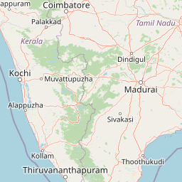
Map view of Anaimalai Tiger Reserve

Use this park location map to pinpoint Anaimalai Tiger Reserve in India, understand its exact geographic position, and read its mapped placement within the surrounding landscape more clearly.

Pigeon | © OpenStreetMap contributors
Park atlas

Map the interconnected protected areas and diverse conservation landscapes of the Anaimalai Hills region.

Discover Nearby Protected Areas and National Parks Surrounding Anaimalai Tiger Reserve

Browse other national parks and protected areas geographically adjacent to Anaimalai Tiger Reserve, encompassing diverse conservation landscapes across the Western Ghats in India. Comparing these regional protected areas reveals shared ecosystems, identifies key ecological corridors, and deepens understanding of contiguous protected geography in peninsular India.
National parkKerala
About 12 km away#1 closest

South

Eravikulam National Park: National Park with Mapped Protected Boundaries in Kerala

Understanding its geographic setting and landscape identity.

Delve into the protected landscape of Eravikulam National Park, a significant national park located in Kerala. This detailed entry focuses on its geographic coordinates, mapped boundaries, and its role as a distinct protected area within the regional geography. It serves as a valuable resource for exploring the park's natural terrain and its importance in conservation landscapes.

Area
97 km²
Established
1978
IUCN
II
Visitors
148.4K annual
National parkKerala
About 26 km away#2 closest

Southeast

Anamudi Shola National Park: Protected Montane Forest and Wildlife Corridor in Kerala

Explore unique high-altitude ecosystems and regional landscape context.

Anamudi Shola National Park is a compact yet ecologically significant protected area situated in the Western Ghats of Kerala, India. Covering around 7.5 square kilometers, the park preserves rare montane shola forests at elevations exceeding 2,100 meters. Its identity as a critical wildlife corridor, connecting contiguous protected zones, is fundamental to its conservation value. The park's landscape, defined by its unique ecosystems and regional geographic position, offers valuable insights for atlas-driven exploration of protected natural areas.

Area
7.5 km²
Established
2003
IUCN
II
Relief
Mountain
National parkIndia
About 38 km away#3 closest

Southeast

Pampadum Shola National Park: India's Protected Area Landscape Details

Explore mapped terrain and geographic context for this national park.

Gain insight into Pampadum Shola National Park, a key protected area within India's geography. This park detail provides essential information on its designation as a national park, its mapped boundaries, and its contribution to the regional landscape. It serves as a vital point for understanding the distribution and character of protected lands across India, offering a foundation for structured geographic research and atlas-based discovery of natural environments.

National parkIdukki
About 43 km away#4 closest

South

Mathikettan Shola National Park: National Park Exploration and Geographic Mapping

Discover its protected landscape and regional context.

Mathikettan Shola National Park, a designated national park in the Idukki region, offers a focal point for understanding protected landscapes and their geographic distribution. This entry details the park's mapped boundaries and its specific setting within the regional geography, providing an atlas-level view of its conservation value. Users can explore the structured geographic identity of this protected natural area, enriching their understanding of India's park network.

Area
12.82 km²
Established
2003
IUCN
II
Relief
Mountain
National parkKerala
About 94 km away#5 closest

South

Periyar National Park: National Park Protected Area Atlas and Geographic Context

Mapped protected lands and regional landscape exploration in Kerala.

Discover Periyar National Park as a distinct protected landscape offering rich geographic context for atlas exploration. This entry details its mapped boundaries and its significance within the broader regional geography of Kerala. Understand the natural terrain and protected-area distribution that makes Periyar National Park a key element in India's conservation mapping.

Area
350.54 km²
Established
1982
IUCN
II
Visitors
754.3K annual
Protected areaIndia
About 100 km away#6 closest

Southwest

Vembanad Protected Area: Mapping India's Iconic Kerala Backwaters and Wetland Landscape

An extensive inland lake system featuring tidal lagoons, islets, and below-sea-level agricultural plains.

Spanning over 96 kilometers, Vembanad forms a sprawling wetland environment that acts as the primary drainage basin for much of Kerala. Analyze the geography of its intricate shorelines, mangrove patches, and historic islets like Pathiramanal. This protected zone provides a critical habitat for thousands of waterbirds while illustrating the complex relationship between coastal estuaries and human-managed landscapes.

Area
2,033.02 km²
Relief
Lowland
Climate
Tropical
Access
Easy access
Watercolor illustration of green hills, a river, and distant pink mountains
National parkKerala
About 102 km away#7 closest

Northwest

Silent Valley National Park: Kerala's Protected Landscape and Geographic Atlas

Explore mapped boundaries and regional terrain in South India.

Silent Valley National Park stands as a key protected area within Kerala, India, offering rich insights into its geographic setting. This destination provides an atlas-driven view of the park's mapped boundaries, its integration with the surrounding regional geography, and the character of its natural landscapes. Users can engage with detailed information designed for structured exploration of protected natural areas and their mapped contexts.

Area
89.52 km²
Established
1984
IUCN
II
Relief
Mountain
National parkNilgiri District
About 114 km away#8 closest

Northwest

Mukurthi National Park: Nilgiri District's Protected Montane Grassland and Shola Ecosystem

Explore a vital refuge for the endangered Nilgiri tahr.

Mukurthi National Park, situated in the Nilgiri District of India, is an essential protected area celebrated for its distinctive montane landscape. This national park plays a critical role in the survival of the endangered Nilgiri tahr, protecting the rare shola-grassland ecosystem where they thrive. Its dramatic terrain, high elevations, and unique ecological associations make it a focal point for understanding conservation geography and the mapped boundaries of protected lands within the Western Ghats.

Area
78.46 km²
Established
1990
IUCN
II
Relief
Mountain

Common questions about visiting, size, designation, and location context for Anaimalai Tiger Reserve

Anaimalai Tiger Reserve FAQs for park facts, access, geography, and protected area context

Find quick answers about Anaimalai Tiger Reserve, including protected-area facts, park geography, trail and visitor context, and how the park fits into its surrounding country and regional landscape.
MoriAtlas Explorer

Continue Your Protected Areas Search Across the Global Atlas

Deepen your exploration by continuing the structured search for national parks and protected areas worldwide. Utilize the comprehensive filtering capabilities to compare different conservation landscapes and refine your understanding of global park geography. Discover more about the distribution and characteristics of protected natural areas.

Global natural geography