

Mori Atlas logo
Nature reserveAndanan Watershed Forest Reserve

Mapping the high-elevation forest corridors and riparian terrain of the Diwata Mountains.

Andanan Watershed Forest Reserve: A Protected Mountain Landscape and Watershed in Agusan del Sur

The Andanan Watershed Forest Reserve covers over 15,000 hectares of rugged mountainous terrain within the Diwata Mountains of Agusan del Sur. This nature reserve serves as a vital hydrological anchor, safeguarding the headwaters of the Andanan River and surrounding streams. The landscape features a complex mosaic of old-growth dipterocarp forest, reforested zones, and grasslands that provide critical habitat for endemic wildlife across the Caraga region.

watershed reserveMindanaoDiwata MountainsAgusan del Surtropical forestdipterocarp forest

Andanan Watershed Forest Reserve

Nature reserve

Park overview

Structured park overview, official facts, and landscape profile for Andanan Watershed Forest Reserve

Andanan Watershed Forest Reserve park facts, protected area profile, and essential visitor context

Review the core facts for Andanan Watershed Forest Reserve, including designation, size, terrain, visitor scale, habitats, and operating context in one park-focused overview.

About Andanan Watershed Forest Reserve

The Andanan Watershed Forest Reserve is a substantial protected landscape in the interior of Mindanao, anchoring both the hydrology and biodiversity of a significant portion of Agusan del Sur. Located near Bayugan City and set entirely within the Diwata Mountains, the reserve covers about 15,097 hectares in a landscape mosaic of approximately 7,929 hectares of forest, 1,668 hectares of reforested land, and 5,500 hectares of grassland and pasture.

Its defining role is as a watershed. The reserve collects rainfall across its upland slopes and channels it into the Andanan River and the Muraya, Calaitan, and Pinandagatan creeks. Annual rainfall in the area averages around 2,000 millimeters, with the heaviest precipitation falling between December and March, when monthly totals can reach about 250 millimeters. This consistent supply of water supports agriculture, settlements, and downstream ecosystems in the Caraga region, making Andanan an essential piece of regional water infrastructure as much as a wildlife refuge.

Ecologically, the reserve is significant because its forest cover and elevation patterns shelter a surprising range of species in a relatively compact area. Amphibians and reptiles in particular thrive here: surveys have recorded 49 herpetofaunal species, including 22 frog species and 17 lizard species, alongside freshwater turtles and several snake species. A few of these, including the Mindanao-endemic Platymantis rabori frog and the Philippine-endemic pit viper Trimeresurus flavomaculatus, give the area real biogeographic importance.

The reserve also fits within a broader national framework. Proclaimed under Presidential Decree No. 734 in 1991, it was later incorporated into the NIPAS system under Republic Act 7586, where it is listed as Andanan Natural Park. Together with other Caraga reserves such as Agusan Marsh, Cadabaran-Santiago, Mahaba Island, and the Siargao Islands, it forms part of one of the Philippines' most ecologically diverse regional networks of protected areas.

Quick facts and research context for Andanan Watershed Forest Reserve

The Andanan Watershed Forest Reserve lies in Agusan del Sur province on Mindanao, Philippines, immediately west of Bayugan City. It encompasses roughly 15,097 hectares within the Diwata Mountains, divided between forest, reforested land, and grasslands.

The reserve was proclaimed by Presidential Proclamation No. 734 in 1991 and is now integrated into the country's National Integrated Protected Areas System under Republic Act 7586. It serves as the headwater catchment for the Andanan River and the Muraya, Calaitan, and Pinandagatan creeks, and receives around 2,000 millimeters of rainfall annually, with the wettest months running from December through March.

Protection and recognition

Examine documented terrestrial protection scope and official conservation records

Andanan Watershed Forest Reserve Protection Status and Governance Framework

Andanan Watershed Forest Reserve maintains a defined terrestrial protection scope within the global protected area registry. Documented conservation records provide structured insight into its official status and administrative management framework.

Protection details

Protection scope
Terrestrial
Transboundary protection
No
WDPA ID
306540
Park context

Deeper park guide and search-rich context for Andanan Watershed Forest Reserve

Andanan Watershed Forest Reserve history, landscape, wildlife, and travel context

Explore Andanan Watershed Forest Reserve through its history, landscape character, ecosystems, wildlife, conservation priorities, cultural context, and seasonal travel timing in a structured park guide built for atlas discovery and search intent.

Why Andanan Watershed Forest Reserve stands out

Andanan is best known as a watershed reserve that protects the headwaters of the Andanan River and several associated streams flowing down from the Diwata Mountains. Its combination of watershed function, upland forest cover, and unusually high amphibian and reptile diversity gives it a distinctive identity among Mindanao's protected areas. The reserve is also notable for harbouring the Mindanao-endemic forest frog Platymantis rabori and the Philippine-endemic pit viper Trimeresurus flavomaculatus, along with a rich community of hornbills, parrots, raptors, and forest butterflies.

Andanan Watershed Forest Reserve history and protected-area timeline

The area now known as the Andanan Watershed Forest Reserve was formally designated as a natural and watershed reserve by Philippine Presidential Proclamation No. 734, issued on 29 May 1991. This proclamation recognized both its ecological value and its critical role in supplying clean water to surrounding lowland communities through the Andanan River system.

Following the passage of the National Integrated Protected Areas System Act, or Republic Act 7586, in 1992, Andanan was integrated into the country's wider NIPAS framework. Within this system it is referenced as Andanan Natural Park, reflecting its upgraded status as part of the national network of protected landscapes. The formal founding date associated with the reserve is 5 April 2011, which corresponds with milestones in its NIPAS administration rather than the initial 1991 proclamation.

Andanan Watershed Forest Reserve landscape and geographic character

The Andanan Watershed Forest Reserve sits within the Diwata Mountains, the long ridge system that runs through northeastern Mindanao and forms the spine of the Caraga region's interior terrain. Within the reserve, slopes are steep and dissected by streams, with elevations rising from the river valleys up into forested ridges.

The landscape is not uniformly wooded. Rather, it is a patchwork of about 7,929 hectares of forest, 1,668 hectares of reforested land, and 5,500 hectares of grassland and pasture. This mosaic reflects both the natural vegetation patterns of the Diwata Mountains and the long history of human land use in the region, where clearing for grazing and small-scale agriculture has alternated with reforestation efforts.

The defining geographic feature is the Andanan River itself, whose headwaters emerge from the reserve, joined by the Muraya, Calaitan, and Pinandagatan creeks. These waterways carve narrow valleys through the lower slopes, creating the corridor through which rainfall collected across the wider catchment ultimately drains into the Agusan river system farther downstream.

Andanan Watershed Forest Reserve ecosystems, habitats, and plant life

Ecologically, Andanan sits at the intersection of lowland tropical forest and montane environments typical of the Diwata range. Its humid conditions, fed by roughly 2,000 millimeters of annual rainfall, sustain dense vegetation across both primary forest stands and reforested areas.

The forest canopy is dominated by dipterocarp species characteristic of Philippine upland forests. Common canopy trees include Yakal, Lauan, Mayapis, Apitong, Tanguile, Bagtikan, and Red Lauan. The presence of these large dipterocarps signals that significant portions of the reserve still support mature, structurally complex forest, even where adjacent areas have been converted to grassland or pasture.

Beyond its forests, the reserve also retains large tracts of open grassland and regenerated land, which contribute to habitat diversity and support different groups of birds, reptiles, and invertebrates than the closed-canopy forest. Stream corridors and moist valleys add a riparian layer to the ecosystem, providing habitat for frogs, freshwater turtles, and a variety of fish, including eels and snakehead species.

Andanan Watershed Forest Reserve wildlife and species highlights

The reserve hosts a broad mammal community typical of Mindanao's forested uplands, including the Philippine deer, wild pigs, a Philippine relative of the Javan macaque, and several rodent species. These mammals depend on the remaining forest blocks and the transitional forest-grassland edges for food and cover.

Birdlife is one of Andanan's most visible wildlife assets. Hornbills and parrots are regularly recorded, along with raptors such as the Brahminy kite and the Philippine hawk-eagle, and forest doves including the Philippine black-striped dove. Together they signal that the reserve still supports the kind of structurally varied forest that many Philippine forest birds need to persist.

Andanan Watershed Forest Reserve conservation status and protection priorities

Andanan's conservation value rests on the combination of watershed protection and the unusually rich herpetofaunal community found within its forests. Surveys of the reserve have documented 49 reptile and amphibian species, including 22 frog species and 17 lizard species. Among these, the Mindanao-endemic forest frog Platymantis rabori and the Philippine-endemic pit viper Trimeresurus flavomaculatus are particularly significant for conservation, representing lineages with highly restricted distributions.

The reserve's butterfly fauna is also notable: surveys have documented species spanning seven superfamilies, 13 families, 24 subfamilies, 49 genera, and 54 species. Among the largest recorded species are the Philippine-endemic Samia luzonica and the striking Troides rhadamantus, both of which depend on intact forest habitats to maintain stable populations.

By integrating Andanan into the NIPAS system, the Philippines has placed the reserve within a national framework that provides legal backing for habitat protection, sustainable land management, and biodiversity monitoring. Its role as the headwaters of the Andanan River and several major creeks adds a further conservation argument: protecting the reserve's forest cover safeguards water quality and supply for downstream communities and ecosystems in the Agusan drainage.

Andanan Watershed Forest Reserve cultural meaning and human context

Although the source material does not provide detailed ethnographic content, Andanan sits within the broader cultural landscape of Agusan del Sur, where indigenous Manobo communities and long-established lowland settlements have lived alongside the Diwata forests for generations. The reserve's mix of forest and open land reflects this long coexistence, with traditional land uses such as small-scale agriculture and grazing shaping parts of the landscape alongside older forest stands.

The reserve also forms part of the natural infrastructure that sustains local communities: its headwaters supply water for rice farming, domestic use, and fisheries in the Agusan basin, embedding it in the everyday economic and cultural life of the surrounding region.

Top sights and standout views in Andanan Watershed Forest Reserve

The Andanan Watershed Forest Reserve stands out for combining three features in a single protected area. It is a working watershed, a refuge for Mindanao's upland wildlife, and an important herpetological site whose 49 recorded reptile and amphibian species include endemic frogs and vipers.

Its mosaic of forest, reforested land, and grassland covers more than 15,000 hectares in the Diwata Mountains and anchors the headwaters of the Andanan River, making it both an ecological stronghold and a critical piece of regional water infrastructure within the Caraga network of protected areas.

Best time to visit Andanan Watershed Forest Reserve

Rainfall shapes the experience of Andanan more than temperature does. The wettest stretch of the year runs from December through March, when monthly precipitation can reach roughly 250 millimeters and the mountainous terrain is at its most lush and water-filled, though trails and stream crossings can be more demanding during this period.

Periods outside the heaviest rains typically offer more comfortable conditions for travel into the reserve, with drier ground and easier access to forested areas, while still benefiting from the region's consistently humid tropical climate.
Monthly climate preview

Long-term representative averages of annual temperature and precipitation rhythm

Andanan Watershed Forest Reserve Climate and Monthly Temperature Normals

Andanan Watershed Forest Reserve tracks measured long-term temperature and daily precipitation values across a representative coordinate in Agusan del Sur. Opening the complete monthly record reveals detailed annual variations in average minimum and maximum temperatures throughout the year.
Annual mean25 °C
24 °C26 °C
Jan24°
Feb24°
Mar24°
Apr25°
May26°
Jun26°
Jul25°
Aug26°
Sep25°
Oct25°
Nov25°
Dec24°
Warmest month
May

25.9 °C

Coolest month
February

23.8 °C

Wettest month
January

15.1 mm/day

Driest month
May

5.2 mm/day

Park location guide

Geography guide, regional context, and park location map for Andanan Watershed Forest Reserve

Andanan Watershed Forest Reserve park geography, regions, and map view in Philippines

Understand where Andanan Watershed Forest Reserve sits in Philippines through a broader geographic reading of the surrounding landscape, nearby location context, and its mapped position within the national park landscape.

How Andanan Watershed Forest Reserve fits into Philippines

The Philippines, officially the Republic of the Philippines, is an archipelagic nation in Southeast Asia comprising approximately 7,641 islands categorized into three main geographical divisions: Luzon, Visayas, and Mindanao. Located in the western Pacific Ocean, it shares maritime borders with Taiwan, Japan, Palau, Indonesia, Malaysia, Vietnam, and China. Manila serves as the capital city, while Quezon City is the most populated city, both within Metro Manila.

Wider geography shaping Andanan Watershed Forest Reserve in Philippines

The Philippines is an archipelagic nation in Southeast Asia, positioned in the western Pacific Ocean. Its islands are bounded by the South China Sea to the west, Philippine Sea to the east, and Celebes Sea to the south. The country shares maritime borders with Taiwan to the north, Japan to the northeast, Palau to the east and southeast, Indonesia to the south, Malaysia to the southwest, Vietnam to the west, and China to the northwest.

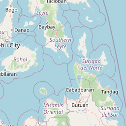
Map view of Andanan Watershed Forest Reserve

Use this park location map to pinpoint Andanan Watershed Forest Reserve in Philippines, understand its exact geographic position, and read its mapped placement within the surrounding landscape more clearly.

Pigeon | © OpenStreetMap contributors

Location context for Andanan Watershed Forest Reserve

Agusan del Sur
Park atlas

Compare regional ecosystems and connected upland landscapes across Mindanao

Explore Protected Areas and Parks Near Andanan Watershed Forest Reserve

Browse other protected areas and mountain reserves located near Andanan Watershed Forest Reserve in the surrounding Caraga region. Comparing these neighboring habitats provides a broader geographic view of upland tropical forests and regional watershed catchments.
Wildlife reserveAgusan del Norte
About 39 km away#1 closest

North

Cabadbaran-Santiago Watershed Forest Reserve: Atlas and Geographic Context

Protected watershed landscapes of the Diwata mountain range

Cabadbaran-Santiago Watershed Forest Reserve serves as a primary forest stronghold in Agusan del Norte. This protected area shields the headwaters of the Cabadbaran and Narog river systems, featuring a diverse topographical mosaic of steep ridges, forested gorges, and montane slopes that define the northern section of the Diwata mountain range.

Area
160.25 km²
Established
1991
Relief
Mountain
Scope
Terrestrial
Wildlife reserveAgusan del Sur
About 59 km away#2 closest

South

Agusan Marsh Wildlife Sanctuary: Mapping a Vast Freshwater Protected Area

Swamp forests and river basin geography in Agusan del Sur

Agusan Marsh Wildlife Sanctuary represents a crucial freshwater wetland complex within the Agusan River basin. The area is defined by its expansive swamp forests and semi-permanent floating lakes, which serve as essential migratory transit points and support an intricate network of aquatic ecosystems across the Mindanao region.

Area
148.36 km²
Established
1996
IUCN
IV
Relief
Lowland
Protected landscapeSurigao del Norte
About 95 km away#3 closest

North

Mahaba Island Protected Landscape and Seascape: Regional Geography and Island Reserve

A combined coastal and marine protected area in Surigao del Norte.

Spanning both a flat sandy island and its surrounding sea, Mahaba Island Protected Landscape and Seascape illustrates the integrated conservation model of the Philippines. Discover the layered geography of mangrove-fringed shorelines, interior coconut patches, and marine habitats that form this protected reserve in the Caraga region.

Area
57.04 km²
Established
1991
Relief
Lowland
Climate
Tropical
Protected landscapeSurigao del Norte
About 109 km away#4 closest

North

Siargao Islands Protected Landscape and Seascape: Geographic Atlas and Park Profile

Protected marine and island landscapes in Surigao del Norte

Spanning Siargao, Bucas Grande, and surrounding islets, this major reserve offers a unique look at the integration of karst-featured terrestrial landscapes with diverse marine zones. Trace the boundaries of a significant Philippine protected area defined by its dense coral reefs, sheltered lagoons, and expansive seagrass meadows supporting rare coastal biodiversity.

Area
2,789.14 km²
Established
1996
Relief
Upland
Climate
Tropical
National parkLanao del Sur
About 157 km away#5 closest

Southwest

Rungkunan National Park: Mapped Protected Landscape and Regional Geography Overview

Discover Rungkunan National Park's protected boundaries and landscape context.

Gain insight into Rungkunan National Park, a protected national park situated in Lanao del Sur. This page details the park's geographic positioning, mapped outlines, and its significance as a conservation landscape. It provides essential context for understanding the distribution of protected areas and the regional geography of the Philippines, facilitating a deeper atlas-style exploration.

Established
1965
IUCN
V
Water
Minor water
National parkLanao del Sur
About 167 km away#6 closest

Southwest

Salikata National Park: Explore Philippines National Park Geography

Mapped protected area boundaries and regional context.

Investigate Salikata National Park, a key protected area designated as a national park within Lanao del Sur, Philippines. This detailed view provides essential context for understanding its mapped boundaries, its place in the regional geography, and its significance as a protected landscape. Discover the unique geographic attributes that define Salikata National Park for atlas-based exploration.

Established
1965
IUCN
V
Relief
Mountain
Climate
Tropical
National parkLanao del Sur
About 175 km away#7 closest

Southwest

Lake Butig National Park: National Park Atlas and Geographic Discovery in Lanao del Sur

Discover its mapped boundaries and regional landscape context.

Lake Butig National Park is a protected national park in the Philippines, located within Lanao del Sur. This entry provides specific geographic information and supports atlas exploration by detailing the park's mapped boundaries and its place within the regional landscape. Understand the terrain and protected area context crucial for geographic study and understanding Philippine natural landscapes.

Area
0.68 km²
Established
1965
IUCN
V
Relief
Mountain
National parkLanao del Sur
About 175 km away#8 closest

Southwest

Pantuwaraya Lake National Park: National Park Atlas and Mapped Landscape

Explore the protected area and regional geography of Lanao del Sur.

Understand Pantuwaraya Lake National Park as a defined protected landscape and a significant national park within the Philippines. This entry focuses on its geographic placement in Lanao del Sur, providing context for its mapped boundaries and natural features. Users can explore its representation within a broader atlas of protected lands, gaining insight into its role and landscape identity.

Area
0.2 km²
Established
1965
IUCN
V
Climate
Tropical

Common questions about visiting, size, designation, and location context for Andanan Watershed Forest Reserve

Andanan Watershed Forest Reserve FAQs for park facts, access, geography, and protected area context

Find quick answers about Andanan Watershed Forest Reserve, including protected-area facts, park geography, trail and visitor context, and how the park fits into its surrounding country and regional landscape.
MoriAtlas Explorer

Continue Your Protected Areas Search Across the Global Atlas

Deepen your exploration by continuing the structured search for national parks and protected areas worldwide. Utilize the comprehensive filtering capabilities to compare different conservation landscapes and refine your understanding of global park geography. Discover more about the distribution and characteristics of protected natural areas.

Global natural geography