Mori Atlas logo
Nature reserveBadstube Mimbach

A mapped overview of limestone slopes, orchid-rich grasslands, and beech woodland habitats

Badstube Mimbach Nature Reserve: Exploring the Protected Landscapes and Geography of Saarland

(Naturschutzgebiet Badstube Mimbach)

Badstube Mimbach represents a compact and ecologically significant nature reserve situated on the Lower Muschelkalk limestone slopes of the Saarpfalz-Kreis in Saarland. This protected area showcases a distinctive landscape mosaic where nutrient-poor meadows, dry calcareous grasslands, and woodruff beech forests intersect. The site serves as a vital habitat for specialized insect populations and diverse orchid species, reflecting the broader natural character of the Bliesgau region in southwestern Germany.

nature reservecalcareous grasslandorchid habitatNatura 2000 sitebeech forestdry grassland

Badstube Mimbach

Nature reserve

Park overview

Structured park overview, official facts, and landscape profile for Badstube Mimbach

Badstube Mimbach park facts, protected area profile, and essential visitor context

Review the core facts for Badstube Mimbach, including designation, size, terrain, visitor scale, habitats, and operating context in one park-focused overview.

About Badstube Mimbach

Badstube Mimbach is a small but ecologically intense protected area located in the rolling hill country of the Bliesgau, in the eastern part of the Saarland near the French and Rhineland-Palatinate borders. Although it covers only about nine and a half hectares, the reserve represents an unusually complete example of the calcareous hill habitats typical of this part of southwestern Germany.

The reserve sits on slopes of Lower Muschelkalk, a Triassic limestone that underlies much of the Saarland and the northern Bliesgau. Historically, these slopes were used as small terraced fields, and the abandonment of that agricultural use has allowed a very particular vegetation pattern to develop. Open calcareous grasslands, dry meadows, and woodland have come to coexist closely, increasing the number of ecological niches available on a single site.

Within the reserve four formally recognized habitats are documented: an orchid-rich beech forest, a woodruff beech forest, a mesotrophic-style nutrient-poor lowland meadow, and a calcareous dry grassland. The presence of so many habitat types in such a small protected area gives Badstube Mimbach an outsized importance for biodiversity conservation in the Saarpfalz-Kreis, and the landscape mosaic supporting wild orchids, thermophilic insects, and shrub-loving birds.

Quick facts and research context for Badstube Mimbach

Badstube Mimbach is a designated nature reserve situated inside the Bliesgau Biosphere Reserve in the Saarpfalz-Kreis district of Saarland, southwestern Germany. The area was first declared a protected nature reserve on 3 September 1962, with its designation expanded on 24 June 2016.

It covers roughly nine and a half hectares of Lower Muschelkalk slopes featuring terraced old-field landscapes. Four major habitat types are recognized within the reserve: orchid beech forest, woodruff beech forest, species-rich lowland meadow, and calcareous dry grassland, with the latter being especially notable for wild orchid diversity. The site carries both national nature reserve status and a Natura 2000 designation, and is administered by the Saarpfalz-Kreis.

Protection and recognition

Documented Natura 2000 listings and official protected area records

Badstube Mimbach Protection Status and International Recognition Data

Badstube Mimbach holds documented Natura 2000 recognition within official protected area inventories. Conservation records outline the registered boundary scope and international designation details for professional geographic research.
Park context

Deeper park guide and search-rich context for Badstube Mimbach

Badstube Mimbach history, landscape, wildlife, and travel context

Explore Badstube Mimbach through its history, landscape character, ecosystems, wildlife, conservation priorities, cultural context, and seasonal travel timing in a structured park guide built for atlas discovery and search intent.

Why Badstube Mimbach stands out

Badstube Mimbach is best known for its exceptional concentration of wild orchids within calcareous dry grassland on Lower Muschelkalk slopes. The reserve combines orchid beech forest, woodruff beech forest, species-rich meadow, and lime-rich dry grassland in a remarkably small area, producing a habitat mosaic rarely matched elsewhere in the region. This combination of woodland edge and open limestone grassland also makes the site a rich insect habitat, historically documented for unusually high densities of the Bergsingzikade cicada and for thermophilic butterflies such as the golden-checkered skipper. The reserve is therefore regarded as one of the signature orchid and warm-habitat hotspots of the Bliesgau.
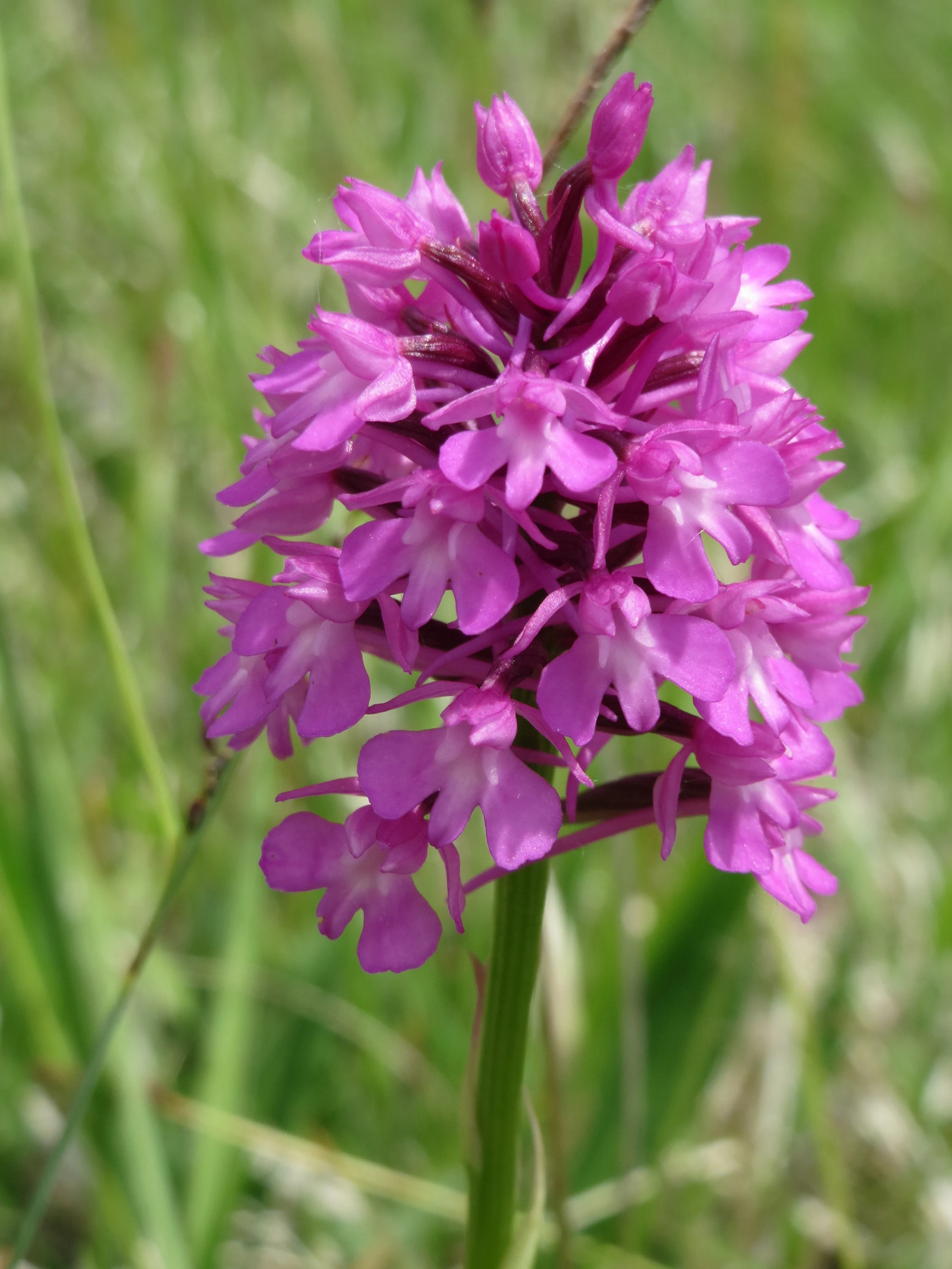
A close-up photograph of a vibrant pink Pyramidal Orchid flower head with a soft-focus green background of grass.
A close-up view of a Pyramidal Orchid (Anacamptis pyramidalis), a flower species found in the limestone grasslands of Badstube Mimbach.

Badstube Mimbach history and protected-area timeline

The site was first declared a nature reserve (Naturschutzgebiet) on 3 September 1962, securing its landscape and habitat values under formal German nature protection law. Its designation was later expanded and renewed on 24 June 2016, reflecting both the continued importance of the area and the need to update the protected-area boundaries and rules.

Throughout the late twentieth and early twenty-first centuries, Badstube Mimbach continued to be recognized as one of the orchid focal points of the Bliesgau. The orchid-rich dry grasslands and the unusually high Bergsingzikade populations documented in 2004 helped confirm its value as a habitat for warm-adapted species and reinforced its status within Saarland's conservation framework.

The reserve also sits within the larger Bliesgau Biosphere Reserve, recognized by UNESCO, which has provided an additional management framework emphasizing the integration of conservation, cultural landscape preservation, and sustainable regional development around sites like Badstube Mimbach.

Badstube Mimbach landscape and geographic character

The landscape of Badstube Mimbach is shaped by the gently rolling Muschelkalk hills that dominate much of the northern Bliesgau. The reserve occupies south- and southwest-facing slopes, an orientation that increases sunlight exposure and helps create the warm microclimate that supports its characteristic dry grassland vegetation.

Although the underlying geology is clearly defined by Lower Muschelkalk limestone, the surface of the reserve still carries the imprint of its agricultural past. Old terraced field structures remain visible across the slopes, and the transition from open grassland to beech forest traces the boundary between formerly cultivated ground and longer-established woodland.

The overall impression is of a small, structured hillside landscape in which forest patches, meadow strips, dry grassland, and relict field terraces meet at short distances. This fine-scale landscape mosaic is one of the most distinctive features of the reserve and contributes directly to its ecological richness.

Badstube Mimbach ecosystems, habitats, and plant life

Ecologically, Badstube Mimbach is notable for the unusual diversity of habitats packed into a very small area. The reserve protects four main vegetation types: an orchid beech forest (Orchideen-Buchenwald), a woodruff beech forest (Waldmeister-Buchenwald), a nutrient-poor lowland meadow (Magere Flachland-Mähwiese), and calcareous dry grassland (Kalk-Trockenrasen).

The calcareous dry grasslands are the most botanically celebrated element of the reserve. Growing on thin, lime-rich soils over Lower Muschelkalk, these grasslands host an exceptionally rich flora with a strong emphasis on wild orchids. The thin soil, the south-facing exposure, and the traditional absence of intensive fertilization together produce the kind of species-rich sward that has become rare across much of lowland Germany.

Alongside the open habitats, the forested parts of the reserve contribute a contrasting set of conditions. The orchid and woodruff beech forest types indicate a relatively undisturbed woodland environment with good soil moisture and stable canopy cover, providing complementary habitat for woodland herbs, fungi, and the shaded forest fauna that depends on them.

Badstube Mimbach wildlife and species highlights

The wildlife profile of Badstube Mimbach is closely tied to its grassland-woodland mosaic. The open calcareous grasslands support thermophilic insects, while the woodland edges and shrubby transitions provide habitat for shrub-loving bird species.

Among the most notable insects documented in the reserve is the Bergsingzikade (a hill cicada), which in 2004 was observed at the exceptionally high density of roughly ten to fifteen exuviae per square metre in parts of the area. This makes the reserve one of the strongest populations of this species in the region. The area also supports the Goldener Scheckenfalter, a warmth-loving butterfly associated with calcareous dry grasslands.

Typical bird species recorded in or around the reserve include Neuntöter (red-backed shrike), which depends on open habitats with tall shrubs and perches, and Turteltaube (European turtle dove), a species of conservation concern that uses transitional woodland and edge habitats. Together, these species give the reserve a meaningful role in supporting both invertebrate and bird diversity in the Saarpfalz-Kreis.

Badstube Mimbach conservation status and protection priorities

Badstube Mimbach holds a dual conservation status. It is formally protected as a Naturschutzgebiet under Saarland nature conservation law, and it is also integrated into the European Natura 2000 network, with the protected site code DE6709301 and a corresponding World Database on Protected Areas entry.

At the regional level, the reserve is part of the Bliesgau Biosphere Reserve, a UNESCO-recognized Biosphärenreservat that fosters conservation alongside cultural landscape management. Within that framework, Badstube Mimbach is valued for its intact calcareous grassland, its orchid communities, and its unusually dense populations of specialist insects such as the Bergsingzikade.

The combination of small size and high habitat diversity gives the reserve a strong conservation-to-area ratio. Protecting such a compact but ecologically rich site is considered particularly important given the broader pressure on calcareous grasslands across central Europe, which have declined sharply due to changes in agricultural use and land abandonment leading to shrub encroachment.

Badstube Mimbach cultural meaning and human context

The cultural context of Badstube Mimbach is closely tied to the traditional farming landscape of the Bliesgau. The terraced slopes in the reserve are not natural formations but the result of centuries of small-scale cultivation, which shaped the open structure of the slopes and prevented them from becoming fully forested.

The Bliesgau itself is recognized as a cultural landscape shaped by generations of farming communities, orchards, and small villages. Within this setting, the reserve represents a place where traditional land use has given way to a secondary, ecologically valuable mosaic of forest and grassland, an outcome valued within the biosphere reserve's broader concept of combining nature protection with cultural heritage.

Top sights and standout views in Badstube Mimbach

The single most distinctive feature of Badstube Mimbach is the combination of orchid-rich calcareous dry grassland with adjacent beech forests on Lower Muschelkalk, concentrated in a protected area of just under ten hectares. This produces an unusually rich orchid flora for such a small site, alongside related habitat for specialist insects.

Equally notable is the reserve's entomological significance, particularly for the Bergsingzikade cicada and the Goldener Scheckenfalter butterfly, both warm-habitat species of conservation interest. The presence of bird species such as the Neuntöter and Turteltaube further strengthens the site's profile as a small but disproportionately rich hotspot for biodiversity in the Saarpfalz-Kreis.

Best time to visit Badstube Mimbach

Badstube Mimbach is best appreciated in late spring and early summer, when the calcareous dry grasslands and orchid beech forests reach their peak flowering season. This is typically the period when wild orchids, including the Pyramiden-Hundswurz highlighted locally for the reserve, are most visible, and when the warm-adapted insect fauna of the dry grasslands is most active.

Late summer can also be rewarding, particularly for observing insects such as the Bergsingzikade and for general grassland and meadow color. As a small terrestrial reserve, the experience here is fundamentally about seasonal vegetation and wildlife rather than infrastructure or visitor programming, so timings tied to flowering and insect activity tend to matter more than calendar logistics.

Monthly climate preview

Measured monthly precipitation patterns and average temperatures for Badstube Mimbach

Badstube Mimbach Climate Normals and Long Term Temperature Records

Representative coordinates track the long term monthly temperature progression and daily precipitation averages across Badstube Mimbach from 1991 to 2020. Examining the complete twelve month profile reveals detailed variations in average minimum and maximum temperature readings for the protected area.
Annual mean10 °C
0 °C20 °C
Jan
Feb
Mar
Apr
May14°
Jun17°
Jul20°
Aug19°
Sep15°
Oct10°
Nov
Dec
Warmest month
July

19.6 °C

Coolest month
January

0.4 °C

Wettest month
December

2.4 mm/day

Driest month
April

1.5 mm/day

Park location guide

Geography guide, regional context, and park location map for Badstube Mimbach

Badstube Mimbach park geography, regions, and map view in Germany

Understand where Badstube Mimbach sits in Germany through a broader geographic reading of the surrounding landscape, nearby location context, and its mapped position within the national park landscape.

How Badstube Mimbach fits into Germany

Germany is a federal republic in Western and Central Europe with a population of over 83 million across sixteen constituent states. It is Europe's largest economy by nominal GDP and a major global exporter and importer. The capital is Berlin, and the country borders Denmark, Poland, Czech Republic, Austria, Switzerland, France, Luxembourg, Belgium, and the Netherlands.

Wider geography shaping Badstube Mimbach in Germany

Germany is located in Western and Central Europe, spanning 357,022 km². It borders Denmark to the north, Poland and the Czech Republic to the east, Austria and Switzerland to the south, and France, Luxembourg, Belgium, and the Netherlands to the west. The country has coastlines on the Baltic Sea and North Sea to the north, with the Alps located in the southern region.

Map view of Badstube Mimbach

Use this park location map to pinpoint Badstube Mimbach in Germany, understand its exact geographic position, and read its mapped placement within the surrounding landscape more clearly.

Pigeon | © OpenStreetMap contributors

Location context for Badstube Mimbach

Saarland
Recorded earthquake history

Review the Historical Earthquake Catalogue for Badstube Mimbach

Examine documented seismic events in the vicinity of Badstube Mimbach through our historical catalogue. This dataset supports geographic discovery by providing event-level details and source records for all earthquakes identified near the nature reserve, curated to ensure transparency in regional seismic history.

Badstube Mimbach Earthquake History

Catalogued events

219 events

Strongest magnitude

Magnitude 4.5

Most recent event

Sep 28, 2008

This history includes earthquakes recorded inside the park or within 50 km of its borders

Visualizing limestone slopes, orchid habitats, and protected terrain

Badstube Mimbach Photos and Landscape Scenery

Photographic records capture the terraced Muschelkalk hills and wildflower meadows that define Badstube Mimbach. Visual documentation reveals the distinct mosaic of calcareous dry grassland and beech woodland across the protected reserve.

A close-up photograph of a vibrant pink Pyramidal Orchid flower head with a soft-focus green background of grass.

Park atlas

Compare adjacent limestone reserves and regional conservation areas

Exploring Parks Near Badstube Mimbach and Surrounding Protected Landscapes

Browsing other protected areas near Badstube Mimbach reveals connected limestone terrain, regional beech forests, and calcareous grassland habitats across the Saarpfalz-Kreis. Expanding the park search helps map out broader ecological patterns throughout the surrounding biosphere reserve.
A soft watercolor illustration depicting a river flowing through a lush green floodplain with trees, grasses, and a hazy background.
Nature reserveSaarland
1.9 km away#1 closest

West

Bliesaue zwischen Blieskastel und Bliesdalheim Nature Reserve and Regional Landscape Geography

Protected floodplain ecosystems in Saarland, Germany

The Bliesaue zwischen Blieskastel und Bliesdalheim protects a near-natural river course and its surrounding floodplain in the Saarland region. The reserve is characterized by complex soil conditions from Buntsandstein and Muschelkalk substrates, supporting a rich network of wetlands, marshes, and meadows that function as a cohesive ecological unit for migratory birds and protected species.

Area
1.981 km²
Established
2015
Relief
Lowland
Climate
Temperate
Nature reserveRheinland-Pfalz
About 7.5 km away#2 closest

East

Monbijou Nature Reserve: Mapped Protected Landscapes in the Südwestpfalz District

Regional geography and conservation of dry grassland habitats

Monbijou stands as a significant twenty-six hectare nature reserve in Rheinland-Pfalz, defined by its mosaic of sun-exposed dry grasslands and forest-edge communities. This protected area plays a crucial role in maintaining rare plant species and uncommon animal habitats within the rolling terrain of the southwestern Palatinate, near the Hornbach stream and the local airfield.

Area
0.26 km²
Established
1978
Scope
Terrestrial
Water
Minor water
Nature reserveGermany
About 8.7 km away#3 closest

North

Taubental Nature Reserve: Protected Landscape and Forest Geography in Germany

Core zone forest conservation in the Saarpfalz district.

Taubental Nature Reserve protects a continuous stretch of mixed broadleaf and coniferous forest situated on the Buntsandstone ridges of southwestern Germany. As a core zone within the Bliesgau Biosphere, it maintains essential habitat connectivity despite its proximity to major regional infrastructure, providing a unique case study in forest preservation within the Saarpfalz-Kreis landscape.

Area
4.26 km²
Established
2007
Nature reserveRheinland-Pfalz
About 10 km away#4 closest

East

Wahlbacher Heide Nature Reserve: Geographic Mapping and Protected Landscape Analysis

Explore the Muschelkalk dry grasslands of the Westpfalz region

Wahlbacher Heide offers a focused look at the calcareous dry grassland habitats within the Westpfalz region of Germany. This nature reserve provides essential insights into the preservation of rare orchids and gentians on Lower Muschelkalk bedrock. Use this mapped resource to understand the interplay between the crescent-shaped open meadows, juniper stands, and the surrounding agricultural corridor that frames this important protected site.

Area
0.074 km²
Established
1985
A soft, artistic watercolor painting showing a wide, tranquil wetland scene with soft green and yellow hues, distant rolling hills, and patches of trees and vegetation in a floodplain environment.
Protected landscapeSaarland
About 10 km away#5 closest

North

Beeder Bruch Protected Landscape: Blies River Floodplain and Wetland Geography in Saarland

A managed riverine sanctuary in the Bliesgau Biosphere Reserve

Beeder Bruch is a formally recognized protected landscape in Saarland, defined by the extensive floodplain of the Blies river. The site integrates wet meadows, riparian forests, and reedbeds, serving as a key European bird protection zone. Visitors can explore the mapped terrain, which utilizes conservation grazing to maintain essential wetland habitats and support local biodiversity within the Bliesgau region.

Area
127 km²
Established
2015
IUCN
V
Nature reserveSaarland
About 11 km away#6 closest

Southwest

Südlicher Bliesgau/Auf der Lohe: Mapped Protected Landscape in Saarland, Germany

Calcareous slopes and meadow habitat conservation areas

Located in the Saarpfalz-Kreis district, Südlicher Bliesgau/Auf der Lohe provides a focused conservation look at the slopes and ridges bordering the Blies river valley. The area showcases Muschelkalk geology and semi-open cultural landscapes, serving as a critical habitat for specialized plant communities within this unique German-French border geography.

Area
15.75 km²
Established
2004
IUCN
IV
A soft watercolor illustration depicting rolling green hills and meadows with subtle hints of pink flora, set against a pale background.
Nature reserveRhineland-Palatinate
About 15 km away#7 closest

Northeast

Battweiler Höhe Nature Reserve: Mapped Protected Landscapes and Ridge Geography in Germany

A vital calcareous grassland habitat in the Zweibrücken hill country

Battweiler Höhe preserves a rare strip of semi-dry, lime-rich grassland on a gentle hill ridge in the Südwestpfalz district. This nature reserve in Rhineland-Palatinate exemplifies specialized habitat conservation, protecting a mosaic of meadows and forest edges that support uncommon plant species like pasqueflowers and orchids. The site is a significant link in the broader regional biotope network, maintaining its ecological health through traditional land management.

Area
0.244 km²
Established
2003
A soft watercolor illustration depicting a panoramic landscape with rolling green hills, distant pink-hued mountains, and a rocky outcrop in the foreground.
Nature reserveSaarland
15 km away#8 closest

West

Birzberg, Honigsack/Kappelberghang bei Fechingen: Saarland Protected Nature Reserve Geography

Mapping the slope woodlands and riparian habitats near Saarbrücken

Spanning 188 hectares across the Saar valley margins, this nature reserve is defined by its varied hillside topography and calcareous soil influence. The protected area supports a complex mosaic of woodland slopes and grassland environments, providing a crucial habitat corridor within the Saarland region of Germany.

Area
1.88 km²
Established
2016

Common questions about visiting, size, designation, and location context for Badstube Mimbach

Badstube Mimbach FAQs for park facts, access, geography, and protected area context

Find quick answers about Badstube Mimbach, including protected-area facts, park geography, trail and visitor context, and how the park fits into its surrounding country and regional landscape.
MoriAtlas Explorer

Continue Your Protected Areas Search Across the Global Atlas

Deepen your exploration by continuing the structured search for national parks and protected areas worldwide. Utilize the comprehensive filtering capabilities to compare different conservation landscapes and refine your understanding of global park geography. Discover more about the distribution and characteristics of protected natural areas.

Global natural geography