Mori Atlas logo
National parkBangan Hill National Park

Discover the mapped terrain and cultural heritage of this key protected area in Nueva Vizcaya.

Bangan Hill National Park: Philippines National Park Geography & Protected Landscape Atlas

Bangan Hill National Park stands as a vital protected landscape within Nueva Vizcaya, Philippines, offering a unique lens into the region's geography and cultural history. This page serves as your gateway to understanding the park's mapped boundaries, its prominent role in the Cagayan Valley's geological context, and the specific natural terrain it encompasses. Explore the significance of this national park as a foundational landmark and a destination for appreciating the broader landscape of northern Luzon.

Cultural heritage siteHiking destinationCatholic religious siteValley landscapeHistorical landmarkProtected area

Bangan Hill National Park

National park

Park overview

Structured park overview, official facts, and landscape profile for Bangan Hill National Park

Bangan Hill National Park park facts, protected area profile, and essential visitor context

Review the core facts for Bangan Hill National Park, including designation, size, terrain, visitor scale, habitats, and operating context in one park-focused overview.

About Bangan Hill National Park

Bangan Hill National Park occupies a distinctive position among Philippine protected areas as a site where natural landscape intersects with colonial history and ongoing religious tradition. Located in Bayombong, Nueva Vizcaya, the park rises from the floor of the Cagayan Valley, a vast agricultural region bounded by two major mountain systems that shape both the physical geography and the ecological character of the area.

The park's establishment in 1995 reflected a growing recognition in the Philippines of the need to protect culturally significant landscapes alongside areas of ecological value. While the park's area of 13.90 hectares is modest compared to larger national parks, its designation acknowledged the importance of preserving a site that represents the founding narrative of an entire province. The Department of Environment and Natural Resources oversees management, balancing conservation objectives with the park's role as a cultural and recreational resource.

Visitors to Bangan Hill experience a landscape shaped by both natural processes and human history. The hike to the observation deck provides views across the productive valley below, where agricultural land extends toward the distant mountain fronts. The park's cultural programming, particularly the Lenten season performances, demonstrates how protected areas in the Philippines can serve as living spaces for traditional practices rather than merely historical monuments.

Quick facts and research context for Bangan Hill National Park

Bangan Hill National Park covers 13.90 hectares in Bayombong, Nueva Vizcaya, Philippines. The park was established on March 29, 1995 under Republic Act No. 7954 and is managed by the Department of Environment and Natural Resources. It sits at coordinates 16.417°N, 121.317°E, with Santiago City in Isabela as the nearest major urban center. The park's landscape features a hilly terrain with an observation deck commanding views of the surrounding valley formed by the Caraballo and Cordillera Central mountain ranges.

Protection and recognition

Documented terrestrial conservation scope and official national park classification.

Bangan Hill National Park Protection Status and Protected Area Designation

Official conservation records for Bangan Hill National Park outline the terrestrial protection status and designated management framework of the reserve. Verification of documented designation parameters offers clear geographic context regarding national conservation boundaries and global registry data.

Protection details

Protection scope
Terrestrial
Transboundary protection
No
Park context

Deeper park guide and search-rich context for Bangan Hill National Park

Bangan Hill National Park history, landscape, wildlife, and travel context

Explore Bangan Hill National Park through its history, landscape character, ecosystems, wildlife, conservation priorities, cultural context, and seasonal travel timing in a structured park guide built for atlas discovery and search intent.

Why Bangan Hill National Park stands out

Bangan Hill National Park is best known for its dual significance as a cultural landmark and a hiking destination. The park is renowned for its role in the founding of Bayombong municipality and the province's first Catholic mass in 1739, making it a site of deep historical importance in the Cagayan Valley region. It is also famous for the annual Stations of the Cross performance during Holy Week, where live actors depict the crucifixion narrative in a tradition maintained by the Diocese of Bayombong. The park's observation deck offers panoramic views of the valley framed by the Caraballo and Cordillera Central mountain ranges, making it a popular year-round hiking destination.

Bangan Hill National Park history and protected-area timeline

Bangan Hill National Park's history stretches back to the early colonial period of the Philippines. In 1739, Father Pedro Freire conducted the first Catholic mass in what would become the province of Nueva Vizcaya at the site that now falls within the park's boundaries. This religious ceremony is historically significant not only for its spiritual importance but also because it coincided with the founding of the municipality of Bayombong, establishing the settlement that would become the provincial capital.

The park's designation as a national park in 1995 came through Republic Act No. 7954, which provided formal protected-area status to sites of national significance. This legislative action reflected the Philippine government's approach to preserving locations that combine natural beauty with historical importance. The park's classification as IUCN Category II indicates its primary function as a national park focused on ecosystem protection while accommodating public use and cultural activities.

The continuation of the Stations of the Cross tradition demonstrates how the park remains embedded in the living religious culture of the region. The Diocese of Bayombong organizes this annual performance, drawing participants and observers from across the province and reinforcing the site's role as a place of communal significance beyond its value as a natural area.

Bangan Hill National Park landscape and geographic character

Bangan Hill rises from the Cagayan Valley floor, forming a prominent topographical feature within the municipality of Bayombong. The park's terrain consists of rolling to steep slopes covered with vegetation typical of the region's tropical environment. The summit area accommodates an observation deck that has become the focal point for visitor activity, offering unobstructed views across the valley landscape.

The surrounding valley is bounded to the east by the Caraballo Mountains and to the west by the Cordillera Central, two major mountain systems that define the geography of northern Luzon. These ranges channel weather patterns and influence the distribution of ecosystems throughout the region. The valleys between these mountain fronts contain productive agricultural land, and the visual connection between the park's heights and the distant peaks forms a key element of the landscape experience.

The combination of elevated terrain, valley views, and the surrounding mountain frameworks creates a landscape that is both visually distinctive and representative of the Cagayan Valley region's character. The park provides a natural vantage point from which to understand the broader geographical context of Nueva Vizcaya.

Bangan Hill National Park ecosystems, habitats, and plant life

The natural environment of Bangan Hill National Park reflects the ecological characteristics of the Cagayan Valley region in northern Luzon. While the park's 13.90-hectare area is relatively small, it supports vegetation communities adapted to the valley's climate and the hill's topographical variation. The park's location within a valley bounded by major mountain ranges places it within a transitional zone between different ecological systems.

The tropical climate of the region supports year-round vegetation growth, and the park's green covering provides habitat for various bird species and small mammals typical of secondary forest and woodland areas. While the park is not specifically designated for endangered species protection, it contributes to the network of green spaces that support biodiversity within the agricultural landscape of the valley. The maintenance of tree cover on the hill itself helps prevent erosion and maintains ecological function within the protected area.

Bangan Hill National Park wildlife and species highlights

The wildlife community in Bangan Hill National Park consists primarily of common bird species and small mammals found throughout the Cagayan Valley region. The park's vegetation provides nesting and foraging habitat for various passerine birds, while the mixed tree and shrub cover supports populations of small mammals including rodents and bats. The surrounding agricultural landscape influences the species composition, as many animals utilize both the protected area and the cultivated lands nearby.

While the park does not feature particularly rare or endangered species, it functions as a refuge within a largely agricultural landscape. The green coverage provided by the park's vegetation maintains connectivity for wildlife movement and provides breathing space within the human-modified environment of the valley. Visitors may observe various bird species while hiking the trails, particularly during early morning hours when bird activity is highest.

Bangan Hill National Park conservation status and protection priorities

Bangan Hill National Park represents the category of protected areas in the Philippines where cultural and historical values combine with conservation objectives. The park's designation under Republic Act No. 7954 places it within the national system of protected areas managed by the Department of Environment and Natural Resources. As an IUCN Category II protected area, the park is intended primarily for ecosystem conservation while allowing compatible recreational and cultural uses.

The park's conservation value derives partly from its role in maintaining green space within the Cagayan Valley's agricultural landscape. The vegetation cover helps regulate local microclimate conditions and provides ecosystem services including soil stabilization on the hill's slopes. While the park's small size limits its ecological significance compared to larger protected areas, it contributes to the broader network of protected areas in Nueva Vizcaya and demonstrates how sites of cultural importance can be integrated into conservation planning.

Bangan Hill National Park cultural meaning and human context

The cultural significance of Bangan Hill National Park is deeply rooted in the colonial history of the Cagayan Valley region. The 1739 mass conducted by Father Pedro Freire represents a foundational moment in the Catholic history of Nueva Vizcaya, and the site has maintained its religious importance through continuous use for worship and ceremonial purposes. The founding of Bayombong municipality at this location established the settlement that would become the political center of the province.

The annual Stations of the Cross performance during Holy Week represents a living tradition that connects the park to the contemporary religious life of the community. The Diocese of Bayombong organizes this event, which draws participants from across the province and demonstrates how the landscape serves as a venue for collective religious expression. This tradition transforms the park from a static historical site into an active space where cultural practices continue to unfold.

The intersection of natural landscape and cultural meaning makes Bangan Hill distinctive among Philippine protected areas. The observation deck provides not only scenic views but also a vantage point from which visitors can contemplate the historical narratives attached to the land.

Top sights and standout views in Bangan Hill National Park

Bangan Hill National Park offers visitors a combination of historical exploration, cultural engagement, and natural scenery within a compact protected area. The first mass site marking the 1739 founding of Bayombong provides a direct connection to the province's colonial origins. The annual Stations of the Cross during Lenten season represents one of the region's most significant religious traditions, drawing participants from throughout Nueva Vizcaya. The hike to the summit and observation deck provides panoramic views of the Cagayan Valley framed by the Caraballo and Cordillera Central mountains. The park's accessibility from Santiago City and other population centers makes it a practical destination for visitors interested in combining hiking with cultural and historical exploration.

Best time to visit Bangan Hill National Park

Bangan Hill National Park can be visited throughout the year due to its location in the tropical climate of northern Luzon. The most popular period for visitors coincides with the Lenten season, when the Stations of the Cross performance draws large crowds and the park becomes a center of religious activity. For hiking and landscape viewing, the dry season from November to April generally offers more comfortable conditions with lower humidity and clearer skies. The monsoon season from May to October brings increased rainfall, though the park remains accessible for visitors willing to hike in wet conditions. The mountain views tend to be clearest during the dry months when atmospheric moisture is reduced, providing the best visibility from the observation deck.
Monthly climate preview

Long-term temperature and precipitation averages based on 30-year climatology data

Climate Profile and Monthly Weather Normals for Bangan Hill National Park

Long-term data at 758 meters elevation shows average monthly temperatures ranging from 19 to 25 degrees Celsius, with higher daily precipitation concentrated in the middle of the calendar year. Comparing the complete twelve-month profile reveals the precise shifts in daily minimums, maximums, and rainfall rates across the annual cycle.
Annual mean22 °C
19 °C24 °C
Jan19°
Feb20°
Mar22°
Apr24°
May24°
Jun24°
Jul23°
Aug23°
Sep23°
Oct22°
Nov21°
Dec20°
Warmest month
May

24.4 °C

Coolest month
January

19.3 °C

Wettest month
August

11.7 mm/day

Driest month
February

3.3 mm/day

Park location guide

Geography guide, regional context, and park location map for Bangan Hill National Park

Bangan Hill National Park park geography, regions, and map view in Philippines

Understand where Bangan Hill National Park sits in Philippines through a broader geographic reading of the surrounding landscape, nearby location context, and its mapped position within the national park landscape.

How Bangan Hill National Park fits into Philippines

The Philippines, officially the Republic of the Philippines, is an archipelagic nation in Southeast Asia comprising approximately 7,641 islands categorized into three main geographical divisions: Luzon, Visayas, and Mindanao. Located in the western Pacific Ocean, it shares maritime borders with Taiwan, Japan, Palau, Indonesia, Malaysia, Vietnam, and China. Manila serves as the capital city, while Quezon City is the most populated city, both within Metro Manila.

Wider geography shaping Bangan Hill National Park in Philippines

The Philippines is an archipelagic nation in Southeast Asia, positioned in the western Pacific Ocean. Its islands are bounded by the South China Sea to the west, Philippine Sea to the east, and Celebes Sea to the south. The country shares maritime borders with Taiwan to the north, Japan to the northeast, Palau to the east and southeast, Indonesia to the south, Malaysia to the southwest, Vietnam to the west, and China to the northwest.

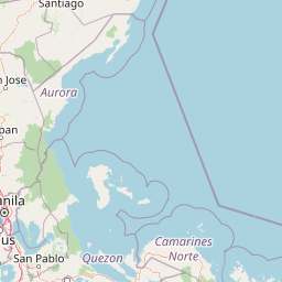
Map view of Bangan Hill National Park

Use this park location map to pinpoint Bangan Hill National Park in Philippines, understand its exact geographic position, and read its mapped placement within the surrounding landscape more clearly.

Pigeon | © OpenStreetMap contributors

Location context for Bangan Hill National Park

Nueva Vizcaya
Park atlas

Explore surrounding protected landscapes and regional park geography within the Cagayan Valley, Northern Luzon.

Discover Other National Parks and Protected Areas Near Bangan Hill National Park

After exploring Bangan Hill National Park, continue your geographic discovery by browsing other protected areas across the Cagayan Valley region and Northern Luzon. Compare diverse landscapes, conservation efforts, and historical sites throughout the Philippines, expanding your understanding of regional park distribution and ecological connections.
Protected landscapeQuirino
About 50 km away#1 closest

East

Quirino Protected Landscape: Exploring the Sierra Madre and Cagayan River Watershed

Mountainous forest geography in the province of Quirino

Spanning roughly two thirds of the province of Quirino, this protected landscape is a strategic natural feature of northern Luzon. Defined by the confluence of the Sierra Madre and Caraballo mountain ranges, it serves as a massive reservoir for the Upper Cagayan River. The terrain consists of dense rainforest ridges, deep river valleys, and isolated peaks, playing a central role in regional biodiversity and watershed conservation.

Area
1,759.44 km²
Established
2004
IUCN
V
Relief
Mountain
Protected landscapeBenguet
About 62 km away#2 closest

West

Upper Agno River Basin Resource Reserve: Mapping the Benguet Watershed Protected Landscape

High-elevation forest, river catchment, and Cordillera peaks

Spanning from the Mount Data area to the Binga Dam, this reserve serves as a pivotal hydropower catchment and mountain sanctuary. Explore the geographic extent of these pine-clad slopes, mossy dwarf forests, and high-altitude grasslands that define the southern Cordillera landscape.

Area
775.61 km²
Established
1966
IUCN
VI
Relief
Mountain
Protected landscapePhilippines
About 63 km away#3 closest

West

Lower Agno Watershed Forest Reserve: Watershed Geography and Mountain Terrain in the Philippines

A vital river corridor and pine forest protected landscape

Explore the structured geography of the Lower Agno Watershed Forest Reserve, defined by its 34.59 kilometer river corridor and dense network of tributaries. From the Benguet pine forests of the Cordillera Central to the industrial landscape surrounding the San Roque Dam, this reserve serves as a complex model of water management, rugged mountain topography, and long term mining heritage in the Philippine highlands.

Area
393.04 km²
Established
1983
IUCN
V
Relief
Mountain
Wildlife reserveNueva Ecija
About 65 km away#4 closest

South

Pantabangan, Carranglan Watershed Forest Reserve: Geography and Protected Area Context

Mountainous watershed landscapes in Northern Nueva Ecija

Spanning the meeting point of the Sierra Madre and Caraballo mountains, this protected wildlife reserve encompasses the massive Pantabangan Lake reservoir. The region provides a complex look at how natural forest ecosystems and large-scale water management infrastructure integrate within the Philippine landscape, offering a unique perspective on regional hydrology and botanical biodiversity.

Area
845 km²
Established
1969
IUCN
VI
Relief
Mountain
Protected landscapeAurora
About 69 km away#5 closest

Southeast

Simbahan-Talagas Protected Landscape: Geographic Profile and Sierra Madre Forest Mapping

An essential watershed and dipterocarp habitat in Aurora province.

Analyze the protected boundaries and hydrological features of the Simbahan-Talagas Protected Landscape. This region features a dense network of river systems and continuous dipterocarp forest cover that extends across the eastern foothills of the Sierra Madre mountain range in Luzon.

Area
22.66 km²
Established
2000
IUCN
V
Relief
Mountain
Protected landscapeAurora
About 70 km away#6 closest

Southeast

Talaytay Protected Landscape: Geography and Protected Area Mapping in Aurora Province

Sierra Madre mountain-to-coast watershed exploration

Analyze the topographic profile and protected boundaries of Talaytay Protected Landscape. This reserve serves as a significant ecological corridor in Aurora, connecting the Sierra Madre interior to the Pacific coast through a series of forested riverine valleys and steep mountain slopes.

Area
35.26 km²
Established
2000
IUCN
V
Relief
Mountain
National parkMountain Province
About 70 km away#7 closest

Northwest

Mount Data National Park: A Protected Highland Watershed in the Mountain Province

Analyzing the topography and mapped forest boundaries of the Cordillera Central

Mount Data National Park serves as a vital protected area in the northern Philippines, anchoring the headwaters of the Agno, Abra, and Rio Chico river systems. This highland site offers a distinct look at the ridge-focused geography of the Cordillera Central, characterized by high-elevation terrain and a long-standing contribution to scientific research on Philippine mammal diversity.

Area
33.52 km²
Established
1936
Relief
Mountain
Scope
Terrestrial
National parkPhilippines
About 72 km away#8 closest

Northwest

Mount Data National Park: Protected Montane Watershed and Philippine Mountain Geography

High elevation forest terrain and regional watershed context.

Located in the Cordillera Central, Mount Data National Park represents a historic protected area of the Philippines. Its montane ecosystems, ranging from pine forests to mossy oak stands, sustain vital downstream river systems while supporting unique biodiversity. This atlas entry provides geographic insights into its steep ridges, forested slopes, and the broader environmental significance of its high-elevation terrain.

Area
55.13 km²
Established
1936
Relief
Mountain
Scope
Terrestrial

Common questions about visiting, size, designation, and location context for Bangan Hill National Park

Bangan Hill National Park FAQs for park facts, access, geography, and protected area context

Find quick answers about Bangan Hill National Park, including protected-area facts, park geography, trail and visitor context, and how the park fits into its surrounding country and regional landscape.
MoriAtlas Explorer

Continue Your Protected Areas Search Across the Global Atlas

Deepen your exploration by continuing the structured search for national parks and protected areas worldwide. Utilize the comprehensive filtering capabilities to compare different conservation landscapes and refine your understanding of global park geography. Discover more about the distribution and characteristics of protected natural areas.

Global natural geography