
Mori Atlas logo
Protected landscapeBeeder Bruch

A managed wetland habitat within the Bliesgau Biosphere Reserve featuring bird protection zones

Beeder Bruch Protected Landscape and Blies River Floodplain Geography in Saarland, Germany

(Landschaftsschutzgebiet Beeder Bruch)

Beeder Bruch represents a critical protected landscape situated within the Blies river floodplain of southwestern Germany. This area forms a distinct ecological corridor characterized by wet meadows, riparian forest fragments, and reedbeds that support diverse bird populations. Through systematic conservation grazing and habitat management, the site functions as both a vital regional bird sanctuary and a central component of the Bliesgau Biosphere Reserve ecosystem.

floodplainriver meadowriparian forestwetlandbird sanctuaryNatura 2000
A graphic illustration of a valley between steep, rocky mountains, with a river, coniferous forest, and a waterfall, framed by dark silhouettes of trees in the foreground.

Beeder Bruch

Protected landscape

Park overview

Structured park overview, official facts, and landscape profile for Beeder Bruch

Beeder Bruch park facts, protected area profile, and essential visitor context

Review the core facts for Beeder Bruch, including designation, size, terrain, visitor scale, habitats, and operating context in one park-focused overview.

About Beeder Bruch

Beeder Bruch is a jointly managed protected landscape and bird sanctuary in the Saarpfalz-Kreis, in the northeastern part of the Saarland. Roughly triangular in shape, the area is bounded by the L 119 road to the north, by the village of Beeden to the southeast, and by the course of the Blies river to the southwest, and it spans parts of two municipalities, the city of Homburg and the municipality of Kirkel. Within its boundaries lies the 30 hectare former nature reserve of Höllengraben, reinforcing the site's importance to regional biodiversity.

The site lies entirely within the Bliesgau Biosphere Reserve, a UNESCO-recognized region that frames the broader cultural and ecological landscape of the Blies valley. Because Beeder Bruch is essentially the floodplain of the Blies, its character is dominated by features typical of a lowland river system: ripian forest fragments, damp and abandoned flood meadows, a network of ditches and ponds, reedbeds, sedge stands, tall herb communities, and small spring-fed flushes. Together these habitats support a wide variety of rare and threatened plant and animal species.

Beeder Bruch receives two complementary layers of protection. As a Bird Protection Area within the Natura 2000 network since 2006, it safeguards habitat for a defined list of breeding, resting, and wintering bird species, ranging from great egret and osprey to common snipe and turtle dove. As a formally designated protected landscape since 2015, it also preserves the wider mosaic of river-valley habitats and their characteristic communities.

Equally important to the park's identity is its role as a local recreation area. Locally promoted as Biotop Beeden, it includes an observation platform on the western edge and an observation pavilion maintained by the Biotop-Verein Beeden. These facilities allow visitors to watch the resident water buffalo, Heck cattle, and Konik wild horses that have grazed the meadows since 2005, while still experiencing the open floodplain landscape that defines this corner of the Saarland.

Quick facts and research context for Beeder Bruch

Beeder Bruch lies in the Saarpfalz-Kreis district of Saarland, between the Homburg districts of Beeden and Schwarzenacker and the Kirkel district of Altstadt. The protected landscape covers roughly 127 square kilometers within the Biophärenreservat Bliesgau and is bounded by the L 119 road to the north, the village of Beeden to the southeast, and the Blies river to the southwest. The site carries the IUCN Category V designation as a protected landscape and also operates as a Natura 2000 bird protection area, formally established in 2006 and designated as a landscape protection area in 2015, with administration handled by the Saarland Office for Environment and Occupational Safety.

Protection and recognition

Review documented conservation frameworks and international recognition records for Beeder Bruch

Beeder Bruch Protection Status and Official Designation Records

Examine the verified protection status, management scope, and official designation details recorded for Beeder Bruch. Access structured conservation data and international recognition metrics compiled within the global protected area registry.

Protection details

WDPA ID
555595957
Park context

Deeper park guide and search-rich context for Beeder Bruch

Beeder Bruch history, landscape, wildlife, and travel context

Explore Beeder Bruch through its history, landscape character, ecosystems, wildlife, conservation priorities, cultural context, and seasonal travel timing in a structured park guide built for atlas discovery and search intent.

Why Beeder Bruch stands out

Beeder Bruch is best known as a Blies river floodplain that has been turned into a working conservation landscape, where traditional grazing animals now share the meadows with rare waterbirds. The site is recognized as an EU Bird Protection Area because of how consistently it functions for breeding, migration stopover, and wintering birds. At the same time, it is celebrated locally as one of the most visited outdoor destinations in the Bliesgau Biosphere Reserve, drawing people to its viewing platforms and observation pavilion to experience a managed wetland-meadow ecosystem up close.
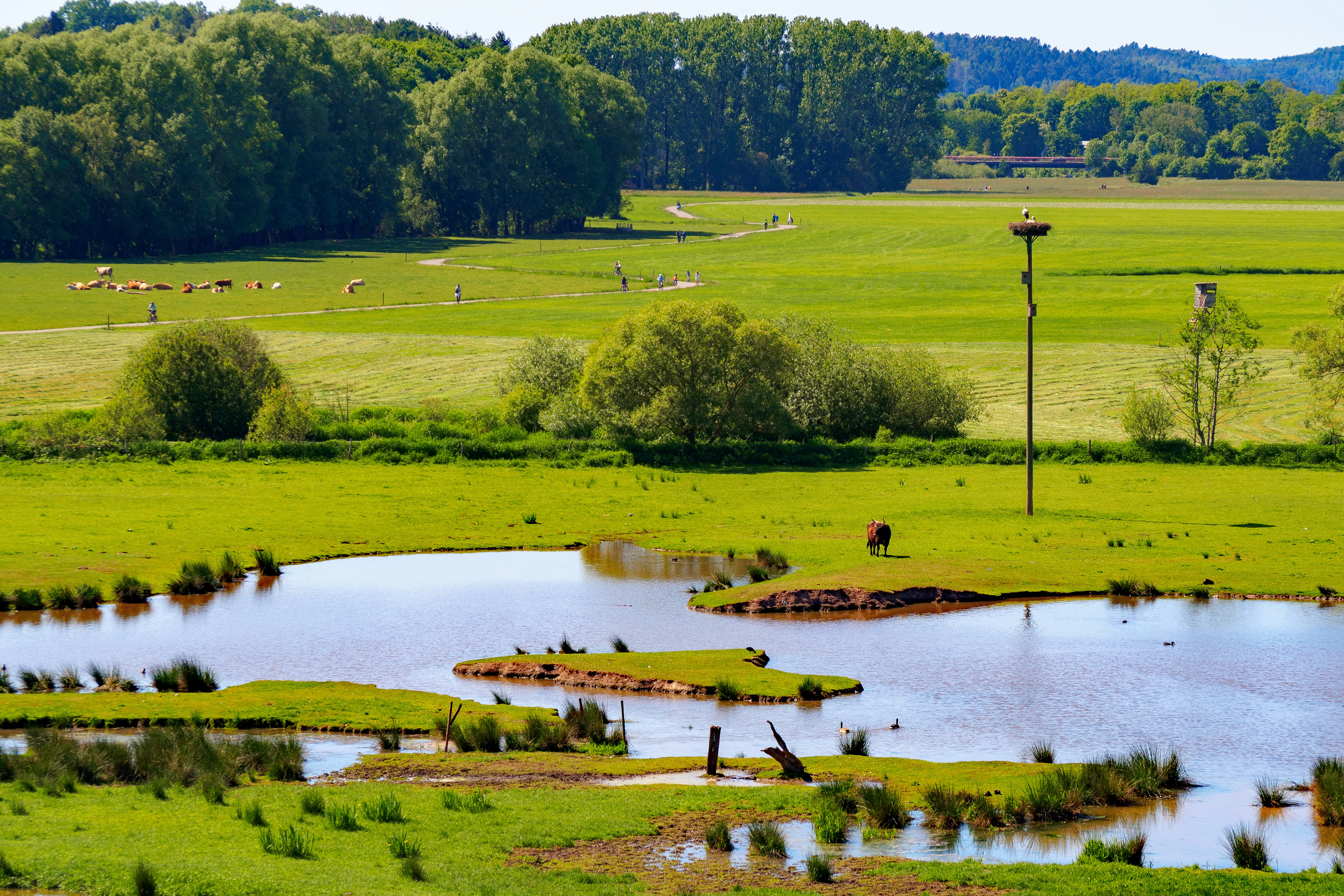
A wide, sunny landscape view of lush green meadows and small marshy ponds. A tall wooden pole with a bird nesting platform stands in the middle distance, and a herd of cattle grazes in the background near a line of trees.
A view of the floodplain wetlands and meadows at Beeder Bruch, featuring grazing livestock and an elevated nesting platform.

Beeder Bruch history and protected-area timeline

Beeder Bruch's modern protected status is the result of two formal recognition steps that reflected different concerns. The area was first identified as a valuable bird habitat and formally established as a Beedener Bruch EU Bird Protection Area in 2006, anchoring it within the European Natura 2000 network and giving it international conservation significance.

A broader landscape protection designation followed in 2015, when the area was officially declared a landscape protection area, or Landschaftsschutzgebiet, extending protection to the whole mosaic of floodplain habitats and not just to its birdlife. Administration of the site is carried out by the Saarland Office for Environment and Occupational Safety, specifically its nature conservation department, ensuring ongoing management of habitats, species, and visitor infrastructure.

Beeder Bruch landscape and geographic character

The physical landscape of Beeder Bruch is dominated by the floodplain of the Blies river, which forms its southwestern edge and gives the area its characteristic flat, water-shaped character. The floodplain has produced a near-triangular zone of wet, periodically inundated terrain bounded by the L 119 road to the north, the village of Beeden to the southeast, and the Blies itself to the southwest.

Within this defined corridor, the terrain shifts between softwood riparian forest fragments, willow and alder thickets along watercourses, and open floodplain meadows, some still in use, others returning to rough grassland. Ditches, ponds, reedbeds, sedge stands, tall herb communities, and small spring flushes break up the meadows and define the wetland edge. Embedded within this larger setting is the former nature reserve of Höllengraben, around 30 hectares in size, which adds further habitat complexity.
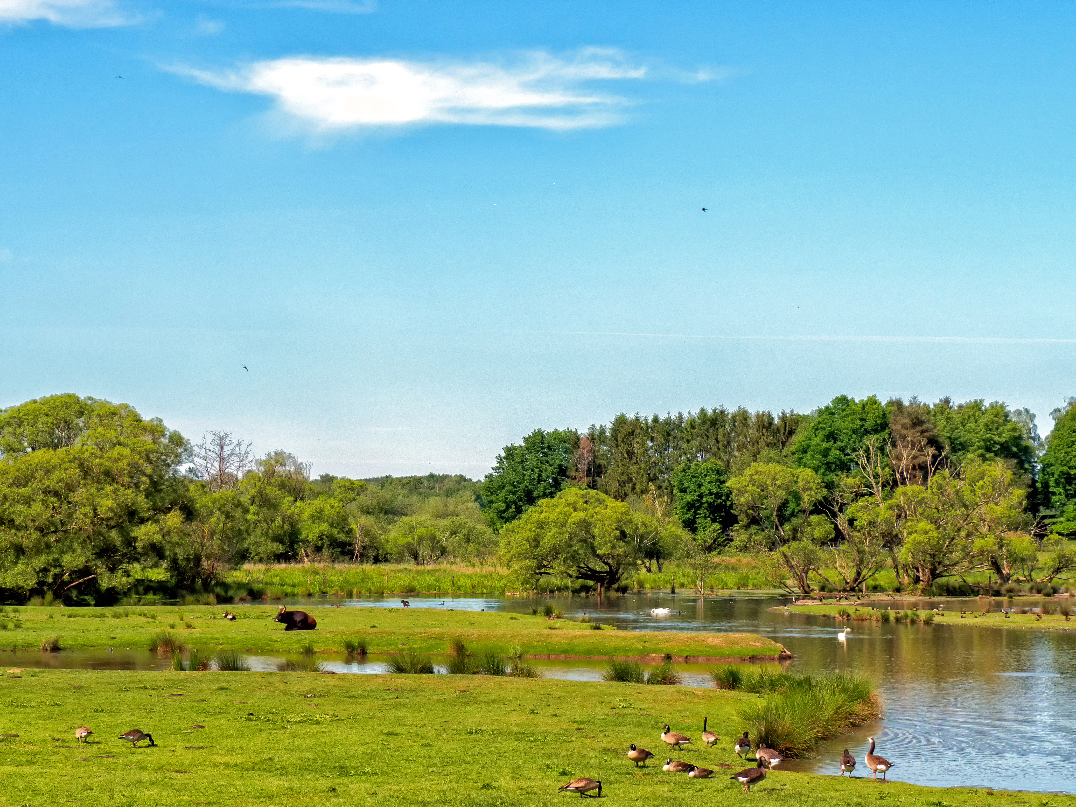
A sunny landscape view of a green floodplain with a winding stream and a flock of geese standing near the water, with a forested background under a bright blue sky.
A scenic view of the floodplain wetlands at Beeder Bruch, featuring lush greenery and a flock of geese along the water.

Beeder Bruch ecosystems, habitats, and plant life

Beeder Bruch functions ecologically as a continuous river-floodplain system rather than a single habitat type. The outwardly diverse vegetation mosaic is in fact a tightly interconnected set of communities shaped by the Blies: remnants of softwood riparian forest, willow-alder thickets, wet and rough meadows, reedbeds, large sedge stands, tall herb and flood-meadow communities, spring flushes, and open water vegetation in ditches and ponds.

These overlapping communities create the structural variety that supports the area's rare and threatened plant and animal life, and they are what the landscape protection designation is intended to preserve. Because the ecological value of the area depends on keeping this entire floodplain mosaic intact, conservation management focuses on maintaining open water, wet soil conditions, and the successional balance between woodland, shrub, and meadow communities.
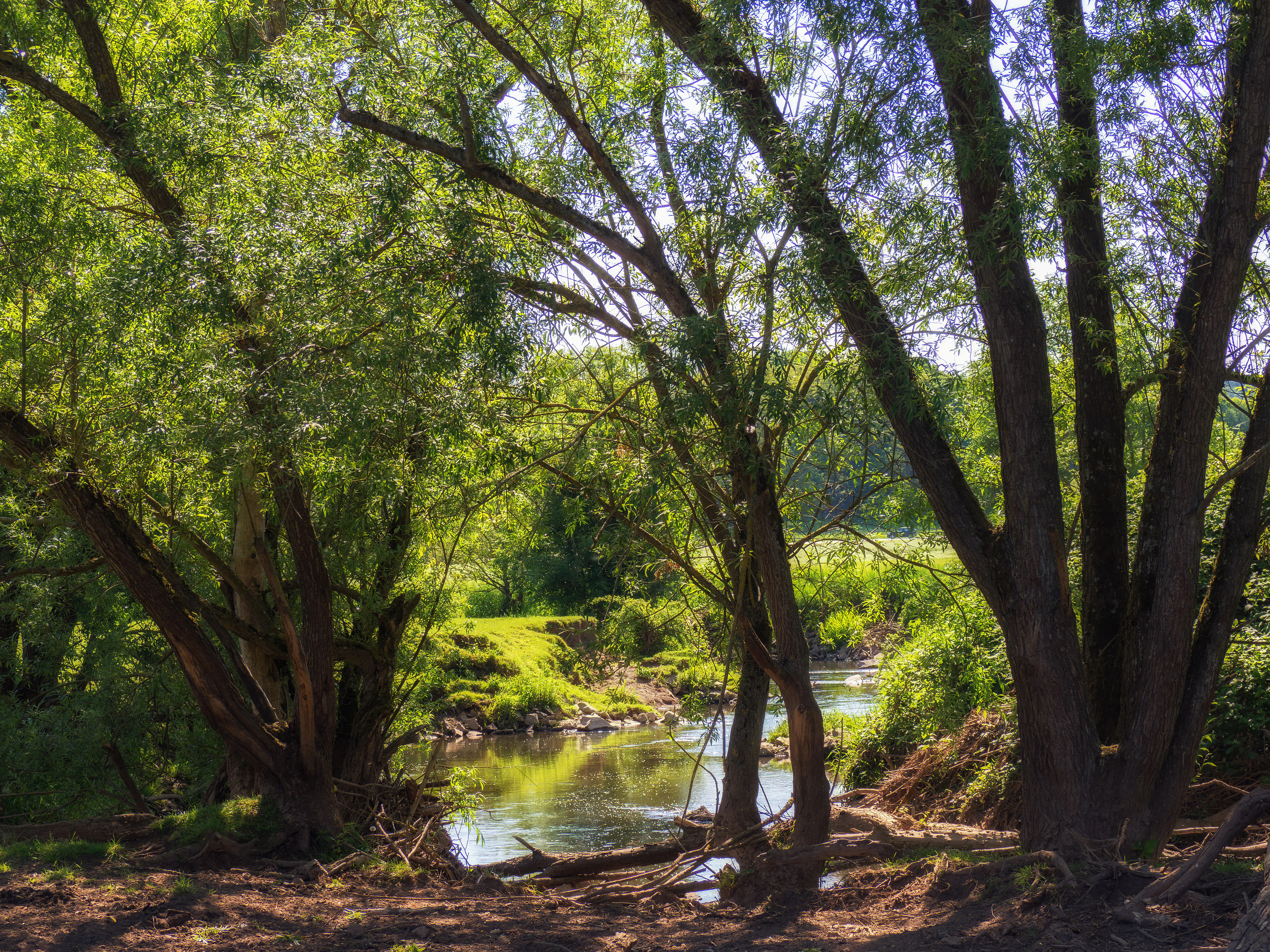
A peaceful stream flows through a lush, green woodland, framed by mature trees along the riverbank.
A shaded view of the Blies riverbank in the Beeder Bruch protected area.

Beeder Bruch wildlife and species highlights

The wildlife profile of Beeder Bruch is built around its function as a major bird habitat in the Saarland, and the European Bird Protection Area designation lists an unusually broad set of species whose breeding, resting, or wintering activity the site is meant to safeguard. Notable breeding, staging, and wintering species include great egret, smew, osprey, common crane, ruff, wood sandpiper, Eurasian wigeon, Eurasian teal, northern pintail, garganey, northern shoveler, Eurasian hobby, little ringed plover, northern lapwing, jack snipe, common snipe, common sandpiper, European turtle dove, common cuckoo, whinchat, and Eurasian golden oriole. The floodplain meadows also host several breeding pairs of white stork.

Large mammals play a distinctive visual role at Beeder Bruch. Water buffalo, Heck cattle, and Konik wild horses graze the meadows, having been introduced around 2005 as part of an ecological management strategy. Their grazing helps maintain open meadow conditions, creates structural diversity for ground-nesting birds, and offers visitors a chance to see semi-wild large herbivores as part of a working floodplain landscape.

Beeder Bruch conservation status and protection priorities

Beeder Bruch matters from a conservation perspective because it preserves a functioning, well-connected Blies valley floodplain at a scale rarely found elsewhere in the Saarland. Its designation as a European Bird Protection Area in 2006 placed it within the Natura 2000 network, tying the site's future management to international species-protection goals covering breeding, migration stopover, and wintering habitat for a long list of waterbirds, waders, and woodland species.

The 2015 landscape protection designation layered a second, broader form of protection over the same area, recognizing that the bird values depend on maintaining the wider mosaic of softwood forest, wet meadows, reedbeds, sedge stands, ditches, and ponds. Habitat management, including the use of large grazers to keep meadows open, is a deliberate conservation tool rather than incidental land use. Embedded within the protected landscape, the 30 hectare former nature reserve of Höllengraben adds a strictly protected core of high biodiversity value inside the larger floodplain system.

Top sights and standout views in Beeder Bruch

The standout features of Beeder Bruch converge in a single landscape: the floodplain of the Blies, where riparian forest, wet meadows, ditches, and reedbeds all meet within a short walk of viewing platforms. The site's double identity as both a European Bird Protection Area and a formally declared protected landscape since 2015 makes it one of the most thoroughly secured floodplain sections of the Saarland. The presence of water buffalo, Heck cattle, and Konik wild horses since 2005 turns the area into a working nature reserve where traditional grazing shapes habitat structure, while an observation pavilion and viewing platform along the western edge make it one of the most visited protected areas in the Bliesgau Biosphere Reserve.

Best time to visit Beeder Bruch

Beeder Bruch is shaped by the seasonal rhythm of a lowland river floodplain, and visiting at different times of year reveals very different aspects of the landscape. Spring and early summer bring the most active birdlife, with breeding waterbirds, waders, and songbirds establishing territories across the meadows and reedbeds, while white stork pairs become visible around their floodplain nests. Late summer and autumn draw migratory species passing through as staging and resting birds, and the reedbeds and ditches can be especially rewarding as water levels change. Winter can produce the largest gatherings of waterfowl and the most open, atmospheric views across the meadows, especially when frost or light snow highlight the floodplain's flat, textured character.

Monthly climate preview

Track representative monthly temperature ranges and precipitation averages across the protected area

Beeder Bruch Climate Normals, Long Term Temperature and Precipitation Patterns

Representative climate data from the coordinate sample reveals long term temperature progression and monthly precipitation averages for Beeder Bruch. Detailed monthly breakdowns provide complete records of average minimum and maximum temperatures across the protected terrain.
Annual mean9 °C
0 °C19 °C
Jan
Feb
Mar
Apr
May13°
Jun17°
Jul19°
Aug19°
Sep14°
Oct
Nov
Dec
Warmest month
July

19.2 °C

Coolest month
January

-0.2 °C

Wettest month
December

2.4 mm/day

Driest month
April

1.5 mm/day

Park location guide

Geography guide, regional context, and park location map for Beeder Bruch

Beeder Bruch park geography, regions, and map view in Germany

Understand where Beeder Bruch sits in Germany through a broader geographic reading of the surrounding landscape, nearby location context, and its mapped position within the national park landscape.

How Beeder Bruch fits into Germany

Germany is a federal republic in Western and Central Europe with a population of over 83 million across sixteen constituent states. It is Europe's largest economy by nominal GDP and a major global exporter and importer. The capital is Berlin, and the country borders Denmark, Poland, Czech Republic, Austria, Switzerland, France, Luxembourg, Belgium, and the Netherlands.

Wider geography shaping Beeder Bruch in Germany

Germany is located in Western and Central Europe, spanning 357,022 km². It borders Denmark to the north, Poland and the Czech Republic to the east, Austria and Switzerland to the south, and France, Luxembourg, Belgium, and the Netherlands to the west. The country has coastlines on the Baltic Sea and North Sea to the north, with the Alps located in the southern region.

Map view of Beeder Bruch

Use this park location map to pinpoint Beeder Bruch in Germany, understand its exact geographic position, and read its mapped placement within the surrounding landscape more clearly.

Pigeon | © OpenStreetMap contributors

Location context for Beeder Bruch

Saarland

Explore protected wetland habitats, river meadows, and conservation grazing environments.

Beeder Bruch Photos and Landscape Scenery: Visualizing the Blies Floodplain

Visual documentation captures the flat riverine terrain, wet meadows, and riparian forest fragments defining the protected floodplain ecosystem. Examining photographic records reveals how active conservation management shapes wetland habitats and bird sanctuary environments across the region.

A wide, sunny landscape view of lush green meadows and small marshy ponds. A tall wooden pole with a bird nesting platform stands in the middle distance, and a herd of cattle grazes in the background near a line of trees.

A white stork standing in a high nest perched on a tall wooden pole in a green meadow, with a grazing animal visible in the foreground and a forest line in the background.

A sunny landscape view of a green floodplain with a winding stream and a flock of geese standing near the water, with a forested background under a bright blue sky.

A peaceful stream flows through a lush, green woodland, framed by mature trees along the riverbank.

Park atlas

Compare regional protected areas and connected floodplain reserves

Explore Other Parks Near Beeder Bruch and Surrounding Protected Landscapes

Browsing parks near Beeder Bruch reveals broader wetland ecosystems and riverine protected landscapes across the surrounding region. Continuing outward from this Blies river floodplain allows for deeper geographic comparison of regional conservation zones.
Nature reserveGermany
About 3.5 km away#1 closest

Southwest

Taubental Nature Reserve: Protected Landscape and Forest Geography in Germany

Core zone forest conservation in the Saarpfalz district.

Taubental Nature Reserve protects a continuous stretch of mixed broadleaf and coniferous forest situated on the Buntsandstone ridges of southwestern Germany. As a core zone within the Bliesgau Biosphere, it maintains essential habitat connectivity despite its proximity to major regional infrastructure, providing a unique case study in forest preservation within the Saarpfalz-Kreis landscape.

Area
4.26 km²
Established
2007
Nature reserveRhineland-Palatinate
About 8.4 km away#2 closest

Northeast

Westricher Moorniederung Nature Reserve: Protected Wetland and Moorland Atlas

Mapping low-lying basin landscapes and riparian corridors in the German Palatinate.

Spanning 40 kilometers between the Bliesaue and Kaiserslautern, the Westricher Moorniederung protects an intricate network of bogs, marsh zones, and alluvial forests. This lowland basin acts as a vital ecological link within Rhineland-Palatinate, defined by its drainage systems and diverse mire habitats. Gain insight into the regional geography and protected land boundaries that define this significant wetland system.

Area
21.52 km²
Established
1998
IUCN
IV
A soft watercolor illustration depicting a river flowing through a lush green floodplain with trees, grasses, and a hazy background.
Nature reserveSaarland
About 9.1 km away#3 closest

South

Bliesaue zwischen Blieskastel und Bliesdalheim Nature Reserve and Regional Landscape Geography

Protected floodplain ecosystems in Saarland, Germany

The Bliesaue zwischen Blieskastel und Bliesdalheim protects a near-natural river course and its surrounding floodplain in the Saarland region. The reserve is characterized by complex soil conditions from Buntsandstein and Muschelkalk substrates, supporting a rich network of wetlands, marshes, and meadows that function as a cohesive ecological unit for migratory birds and protected species.

Area
1.981 km²
Established
2015
Relief
Lowland
Climate
Temperate
Nature reserveSaarland
About 10 km away#4 closest

South

Badstube Mimbach Nature Reserve: Protected Limestone Grasslands and Woodland in Saarland

A regional atlas exploration of Saarland biodiversity hotspots

Badstube Mimbach stands as a significant nature reserve located within the Bliesgau region of Saarland. This protected landscape is defined by its south-facing limestone slopes and terraced fields, providing essential habitat for rare flora and specialized fauna in a compact ten-hectare mosaic of open meadow and beech forest.

Area
0.095 km²
Established
2016
IUCN
IV
Nature reserveRheinland-Pfalz
About 12 km away#5 closest

Northeast

Neuwoogmoor Nature Reserve: Protected Peatland and Wetland Landscape Mapping in Rheinland-Pfalz

Essential geographic data on this historic Palatinate mire system.

Neuwoogmoor serves as a crucial nature reserve in Rheinland-Pfalz, protecting one of the few remaining peat moorland fragments in the Landstuhler Bruch. The site encompasses a diverse mosaic of bog pools, reed beds, and bog woodland that create an intimate and highly structured wetland terrain. This detailed entry provides geographic context on its protected status, hydrological features, and role as a habitat for rare plant communities in the western Palatinate landscape.

Area
0.6 km²
Established
1986
IUCN
IV
Relief
Lowland
A soft watercolor illustration depicting rolling green hills and meadows with subtle hints of pink flora, set against a pale background.
Nature reserveRhineland-Palatinate
About 13 km away#6 closest

East

Battweiler Höhe Nature Reserve: Mapped Protected Landscapes and Ridge Geography in Germany

A vital calcareous grassland habitat in the Zweibrücken hill country

Battweiler Höhe preserves a rare strip of semi-dry, lime-rich grassland on a gentle hill ridge in the Südwestpfalz district. This nature reserve in Rhineland-Palatinate exemplifies specialized habitat conservation, protecting a mosaic of meadows and forest edges that support uncommon plant species like pasqueflowers and orchids. The site is a significant link in the broader regional biotope network, maintaining its ecological health through traditional land management.

Area
0.244 km²
Established
2003
Nature reserveRheinland-Pfalz
About 14 km away#7 closest

Southeast

Monbijou Nature Reserve: Mapped Protected Landscapes in the Südwestpfalz District

Regional geography and conservation of dry grassland habitats

Monbijou stands as a significant twenty-six hectare nature reserve in Rheinland-Pfalz, defined by its mosaic of sun-exposed dry grasslands and forest-edge communities. This protected area plays a crucial role in maintaining rare plant species and uncommon animal habitats within the rolling terrain of the southwestern Palatinate, near the Hornbach stream and the local airfield.

Area
0.26 km²
Established
1978
Scope
Terrestrial
Water
Minor water
Nature reserveRheinland-Pfalz
About 14 km away#8 closest

Southeast

Wahlbacher Heide Nature Reserve: Geographic Mapping and Protected Landscape Analysis

Explore the Muschelkalk dry grasslands of the Westpfalz region

Wahlbacher Heide offers a focused look at the calcareous dry grassland habitats within the Westpfalz region of Germany. This nature reserve provides essential insights into the preservation of rare orchids and gentians on Lower Muschelkalk bedrock. Use this mapped resource to understand the interplay between the crescent-shaped open meadows, juniper stands, and the surrounding agricultural corridor that frames this important protected site.

Area
0.074 km²
Established
1985

Common questions about visiting, size, designation, and location context for Beeder Bruch

Beeder Bruch FAQs for park facts, access, geography, and protected area context

Find quick answers about Beeder Bruch, including protected-area facts, park geography, trail and visitor context, and how the park fits into its surrounding country and regional landscape.
MoriAtlas Explorer

Continue Your Protected Areas Search Across the Global Atlas

Deepen your exploration by continuing the structured search for national parks and protected areas worldwide. Utilize the comprehensive filtering capabilities to compare different conservation landscapes and refine your understanding of global park geography. Discover more about the distribution and characteristics of protected natural areas.

Global natural geography