

Mori Atlas logo
Nature reserveBelchen

Trace the vertical ecological transitions across subalpine grasslands and diverse forest mosaics

Belchen Nature Reserve: A Protected Mountain Landscape in the Southern Black Forest of Germany

(FFH-Gebiet Belchen)

The Belchen protected area encompasses a significant mountain massif in the High Black Forest, representing a rare concentration of European habitat types. Within its boundaries, the landscape shifts from submontane forests to subalpine grasslands, rocky cliffs, and juniper heaths. This site serves as a vital ecological corridor in Baden-Württemberg, supporting a rich assembly of mountain biodiversity and distinct terrain profiles that define the southern German highlands.

Natura 2000FFH areaBlack ForestHigh Black Forestmountain ecosystemsbeech forests

Belchen

Nature reserve

Park overview

Structured park overview, official facts, and landscape profile for Belchen

Belchen park facts, protected area profile, and essential visitor context

Review the core facts for Belchen, including designation, size, terrain, visitor scale, habitats, and operating context in one park-focused overview.

About Belchen

The Belchen protected area is a European Natura 2000 site of community importance in Baden-Württemberg, Germany, encircling the Belchen mountain in the High Black Forest (Hochschwarzwald). Although the management concept is rooted in the European Union's Habitats Directive, the protected footprint is fundamentally shaped by one of the most prominent mountains of the southern Black Forest. Belchen rises prominently above the surrounding valleys and, with its combination of summit cliffs, forested flanks, and high-elevation openings, provides a compressed cross-section of Black Forest environments within a relatively contained area.

Ecologically, the site is notable for the unusually broad spectrum of habitat types packed into its boundaries. On the lower slopes, ancient beech forest communities dominate, including the characteristic Hainsimsen-Buchenwald and Waldmeister-Buchenwald beech woodlands typical of central European mountain forests. As elevation increases, these forests grade into more open subalpine beech forests mixed with sycamore maple, while other slopes give way to Norway spruce forests on acidic soils. Rocky outcrops, cliff faces, and boulder fields add a third structural layer, with habitats of siliceous and calcareous rock vegetation recorded in the area.

Beyond the forested and rocky zones, the Belchen area hosts open habitats that are rare in the broader Black Forest. Dry heaths, juniper heaths, calcareous grasslands, and species-rich mat-grass swards are present, alongside wetter communities such as tall-herb vegetation, transition mires, and dystrophic ponds and hollows. This juxtaposition of dry open habitat and moisture-loving communities on a single mountain gives the site particular ecological significance and contributes to its conservation profile at the European level.

Quick facts and research context for Belchen

The Belchen FFH area lies in the southern High Black Forest of Baden-Württemberg, Germany, centered on the Belchen mountain between the districts of Breisgau-Hochschwarzwald and Lörrach. The site covers 2,907 hectares, with the great majority of its area falling within the municipality of Münstertal/Schwarzwald in Breisgau-Hochschwarzwald.

Designated as a European Fauna-Flora-Habitat area and coming into force on 11 January 2019, the site is managed by the Freiburg Regional Council. It is one of several Natura 2000 sites in the southern Black Forest and forms a connected ecological network with neighboring protected areas such as Nonnenmattweiher and the Wiedener Weidberge nature reserves.

The official site code is DE-8113-341, with the European Nature Information System identifier DE8113341, reflecting its integration into the EU-wide Natura 2000 framework.

Protection and recognition

Explore documented terrestrial conservation history and official Natura 2000 records for Belchen.

Belchen Protection Status and Official International Recognition Facts

Terrestrial protection status for Belchen established in 2019 pairs with documented Natura 2000 records to outline official conservation recognition. Structured protected area metrics deliver reliable administrative context for this designated landscape.

International recognition

Protection details

Protection scope
Terrestrial
Designated year
2019
Transboundary protection
No
WDPA ID
555522116
Park context

Deeper park guide and search-rich context for Belchen

Belchen history, landscape, wildlife, and travel context

Explore Belchen through its history, landscape character, ecosystems, wildlife, conservation priorities, cultural context, and seasonal travel timing in a structured park guide built for atlas discovery and search intent.

Why Belchen stands out

The Belchen FFH area is best known for protecting one of the most ecologically layered mountain landscapes in the southern Black Forest. Within its boundaries, lowland, montane, and subalpine habitat types meet in unusually close proximity, producing a compressed ecological profile that ranges from nutrient-rich beech forests to harsh, wind-exposed summit environments. A defining trait of the site is its combination of forest communities, open grasslands, rocky habitats, and mires. The protected habitats include subalpine beech forests with maple and dock, species-rich mat-grass swards on siliceous soils, boreo-alpine grasslands, juniper heaths, rocky cliff vegetation, and transition mires. Together these features create a mosaic that supports rare species in a relatively compact area. The site is also recognized for its contribution to bat conservation in the Black Forest, hosting protected bat species that depend on the area's mature forests, rocky crevices, and old trees. This mix of habitat variety and species rarity makes Belchen an important reference site for understanding central European mountain biodiversity.
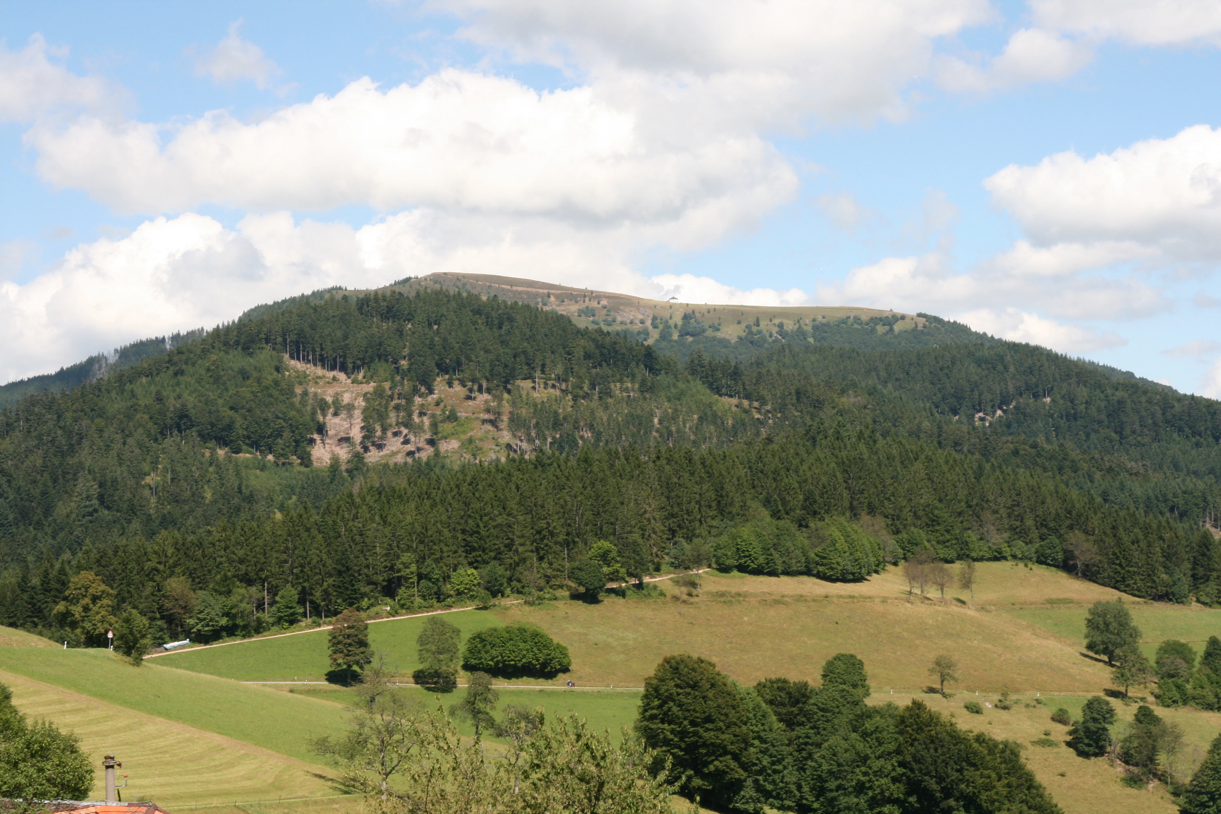
Belchen View
The Stuhlskopf peak with the Belchen in the Black Forest seen from Heubronn or Neuenweg

Belchen history and protected-area timeline

The Belchen protected area has a layered conservation history that reflects both national and European-level nature protection traditions in Germany. The Belchen Nature Reserve (Naturschutzgebiet Belchen) had already been established as a nationally protected area before the European Fauna-Flora-Habitat framework was applied to this landscape, establishing a long-standing tradition of conservation on the mountain itself.

In 2005, the Freiburg Regional Council proposed the Belchen area as a candidate site under the European Union's Habitats Directive, integrating the existing national protection into the Natura 2000 network. Following years of evaluation, the area was formally designated by regulation of the Freiburg Regional Council on 25 October 2018, with the designation entering into force on 11 January 2019. This step elevated the site's legal importance to the European level, recognizing it as an area of community importance for habitats and species.

The site's current boundaries and management responsibilities reflect this dual history. It is administered by the Freiburg Regional Council and incorporates the existing nature reserves of Belchen, Nonnenmattweiher, and Wiedener Weidberge as constituent parts. This means that European-level protection now operates in concert with older national designations, creating a layered governance structure for the mountain's habitats and species.

Belchen landscape and geographic character

The Belchen landscape is shaped by the mountain that gives the site its name, a towering peak in the High Black Forest that rises above deep valleys and forested ridges. The mountain's profile is defined by a narrow rocky summit area that opens abruptly to broader slopes, with coniferous and mixed forests meeting open grasslands, heaths, and cliffs in relatively quick transitions. This vertical compression of habitat zones, from montane forests to subalpine grasslands on a single peak, is a defining visual and ecological feature of the area.

The surrounding valleys frame the Belchen massif and shape its hydrological and ecological context. Streams descending from the mountain's flanks feed wetter communities on the lower slopes, while the higher elevations are exposed to wind and weather conditions that have favored the persistence of open habitats that would otherwise have been reclaimed by forest. Rocky outcrops and scree slopes add to the structural diversity, producing a landscape that is both visually distinctive and ecologically heterogeneous.

Belchen ecosystems, habitats, and plant life

The ecological character of Belchen is built on the unusual diversity of habitat types listed under the European Habitats Directive. Forest communities form the dominant land cover, encompassing several distinct beech forest types that range from lowland beech woods with woodruff to subalpine beech forests with sycamore maple. These are complemented by acidic montane spruce forests, slope and ravine mixed forests, and alder-ash floodplain woodlands along the area's streams.

Beyond the forests, the area's open habitats are equally important to its ecological identity. Dry heaths, juniper heaths, calcareous grasslands, and species-rich mat-grass swards give the site an open-mountain character that contrasts with the broader forested Black Forest landscape. Wetland communities such as transition mires, quaking bog formations, and dystrophic pools add a rare element of moisture-loving habitat, while cliff and scree communities on siliceous and calcareous rocks anchor the summit zones.

This broad habitat spectrum is the basis for the site's Natura 2000 designation. The combination of forest, grassland, heath, wetland, and rocky habitats within a compact mountain setting creates ecological conditions that are unusually rich for the region and that support a notable range of protected species.

Belchen wildlife and species highlights

The Belchen area supports a range of species of European conservation interest, with bats being especially prominent. The site is known to host the Geoffroy's bat, the Bechstein's bat, and the greater mouse-eared bat, all listed under Annex II of the Habitats Directive. These bats rely on the area's mix of mature deciduous forests, rocky crevices, and old structures, making Belchen an important local stronghold for forest-dwelling bat species.

In the streams and smaller waterways of the site, the bullhead, a small freshwater fish listed for conservation, finds suitable habitats. Its presence reflects the relatively clean, structured river systems that descend from the Belchen slopes.

Among invertebrates, the Jersey Tiger moth stands out as a species of community interest, while the rare Buxbaumia viridis, a moss of conservation concern, has also been recorded in the area's forest communities. Together, these fauna and bryophyte records illustrate how the Belchen site functions as a refuge for species that depend on specific mountain forest, freshwater, and rock habitats.

Belchen conservation status and protection priorities

From a conservation perspective, Belchen is significant because it preserves a contiguous block of high-quality mountain habitat that links older national protections with the European Natura 2000 framework. The site's designation as a Fauna-Flora-Habitat area recognizes the European importance of its habitat mosaic, which includes several priority habitat types under the directive, such as species-rich mat-grass swards, subalpine beech forests with maple and dock, and slope and ravine mixed forests.

The site's conservation value is reinforced by its role within a wider network of protected areas in the southern Black Forest. Its overlap with the Belchen, Nonnenmattweiher, and Wiedener Weidberge nature reserves means that legally robust national and European protections stack on top of one another, strengthening the long-term security of habitats like mires, juniper heaths, and old-growth forests. The management responsibility of the Freiburg Regional Council ensures coordinated oversight across these layers.

In practical terms, the conservation framework of Belchen focuses on maintaining the open habitats that depend on traditional land use, protecting forest communities from inappropriate management, and safeguarding the hydrological conditions that support mires and wetland-edge habitats. This combination of habitat variety, layered protection, and targeted management makes the site a meaningful reference for Black Forest mountain conservation.

Top sights and standout views in Belchen

The Belchen protected area stands out for packing a remarkable range of European habitat types into a single southern Black Forest mountain. From lowland beech forests to boreo-alpine grasslands, juniper heaths, and rocky summit communities, the site offers an unusually complete ecological profile for the region.

It is also a significant site for protected bat species, with multiple Annex II bat species recorded within its forests and rocky habitats. Combined with its overlap with established nature reserves and its integration into the Natura 2000 network, Belchen serves as both an ecological stronghold and a reference site for the conservation of central European mountain landscapes.

Monthly climate preview

Long-term climatology data and weather by month for the representative coordinate

Belchen Climate Normals, Average Temperature and Monthly Precipitation Patterns

Representative coordinate measurements record monthly mean temperatures ranging from negative values through moderate summer peaks alongside steady precipitation rates. Reviewing the complete twelve-month record provides deeper insight into long-term climate normals across the protected landscape.
Annual mean8 °C
-2 °C17 °C
Jan-2°
Feb-1°
Mar
Apr
May12°
Jun15°
Jul17°
Aug17°
Sep12°
Oct
Nov
Dec-1°
Warmest month
July

16.8 °C

Coolest month
January

-1.5 °C

Wettest month
May

4 mm/day

Driest month
April

2.6 mm/day

Park location guide

Geography guide, regional context, and park location map for Belchen

Belchen park geography, regions, and map view in Germany

Understand where Belchen sits in Germany through a broader geographic reading of the surrounding landscape, nearby location context, and its mapped position within the national park landscape.

How Belchen fits into Germany

Germany is a federal republic in Western and Central Europe with a population of over 83 million across sixteen constituent states. It is Europe's largest economy by nominal GDP and a major global exporter and importer. The capital is Berlin, and the country borders Denmark, Poland, Czech Republic, Austria, Switzerland, France, Luxembourg, Belgium, and the Netherlands.

Wider geography shaping Belchen in Germany

Germany is located in Western and Central Europe, spanning 357,022 km². It borders Denmark to the north, Poland and the Czech Republic to the east, Austria and Switzerland to the south, and France, Luxembourg, Belgium, and the Netherlands to the west. The country has coastlines on the Baltic Sea and North Sea to the north, with the Alps located in the southern region.

Map view of Belchen

Use this park location map to pinpoint Belchen in Germany, understand its exact geographic position, and read its mapped placement within the surrounding landscape more clearly.

Pigeon | © OpenStreetMap contributors

Location context for Belchen

Baden-Württemberg
Recorded earthquake history

Explore the Documented Earthquake History of the Belchen Protected Area

Examine the historical catalogue of seismic events associated with the surrounding Black Forest landscape. This collection facilitates geographic discovery of recorded earthquake data, mapping historical activity relative to Belchen boundaries for a clear, fact-based perspective on regional seismic patterns.

Belchen Earthquake History

Catalogued events

86 events

Strongest magnitude

Magnitude 4.8

Most recent event

Jun 27, 2024

This history includes earthquakes recorded inside the park or within 50 km of its borders

Visual reference collection showcasing protected habitats and terrain variations across the massif.

Belchen Photos and Mountain Landscape Scenery in the High Black Forest

Visual documentation captures the diverse mountain terrain, steep forest slopes, and open summit grasslands characteristic of the regional protected landscape. Detailed photography illustrates the ecological transitions between submontane forests and wind-exposed rocky habitats within the Black Forest massif.

Belchen View

Park atlas

Compare regional protected areas and neighboring mountain ecosystems across the Black Forest

Exploring Parks Near Belchen and Surrounding Protected Mountain Landscapes

Browsing other protected areas near Belchen reveals the broader ecological spread of the High Black Forest region. Comparing adjacent mountain reserves and forest habitats provides valuable context for regional conservation geography.
Protected landscapeBaden-Württemberg
About 9.5 km away#1 closest

North

Östliches Hexental: Protected Landscape and Regional Geographic Context in Baden-Württemberg

Black Forest valley mosaic and protected meadow systems

Located in the Breisgau-Hochschwarzwald district, Östliches Hexental forms a vital protected landscape of approximately 526 hectares. The region showcases a traditional Black Forest valley structure, defined by riparian gallery forests, orchard meadows, and small field hedges that provide essential habitat connectivity between the High Black Forest and the Markgräfler Hügelland.

Area
5.264 km²
Established
2008
IUCN
V
Protected landscapeBaden-Württemberg
About 14 km away#2 closest

East

St. Blasien Protected Landscape: Geographic Profile and Glacial Mapping

Southern Black Forest protected area in Baden-Württemberg.

The St. Blasien Protected Landscape represents a significant conservation zone in the southern Black Forest. Defined by its strong glacial influence, the area showcases a complex terrain of trough valleys, moraine ridges, and rocky crests alongside centuries-old alpine pastures. Its role in the regional conservation network makes it a key site for understanding the intersection of Pleistocene geography and traditional land management in Germany.

Area
35.754 km²
Established
2002
IUCN
V
Protected landscapeBaden-Württemberg
About 15 km away#3 closest

Northeast

Wagensteigtal-Höllental Protected Landscape: Geography and Terrain of the Black Forest

A bridge between regional natural zones in Baden-Württemberg

Wagensteigtal-Höllental serves as a quintessential example of protected Black Forest geography. Stretching across the Breisgau-Hochschwarzwald district, this area features the steep Rotbach gorge, dense forest ridges, and the prominent Hirschsprung rock formation. It provides a foundational look at how historical transport corridors and natural river breakthrough channels shape the modern landscape identity of southwestern Germany.

Area
29.118 km²
Established
1975
IUCN
V
Relief
Mountain
Nature reserveBaden-Württemberg
About 18 km away#4 closest

South

Dinkelberg und Röttler Wald: Geographic Overview of this Baden-Württemberg Nature Reserve

Protected karst landscapes and mature beech forest habitat

Uncover the ecological and physical geography of Dinkelberg und Röttler Wald, a protected area stretching across diverse limestone plateaus and sandstone slopes in Germany. This site offers a valuable look at managed cultural landscapes that bridge the gap between rural meadows and wild forest reserves, providing critical habitat for European bat populations and rare flora across its varied elevational zones.

Area
46.47 km²
Established
2015
Protected landscapeBaden-Württemberg
About 18 km away#5 closest

South

Südwestlicher Dinkelberg Protected Landscape and Dinkelberg Plateau Geography

Karst terrain and forest habitats in Baden-Württemberg

Located in the Lörrach district, Südwestlicher Dinkelberg protects a diverse mix of ravine forests, dry grasslands, and mires. The area preserves essential ecological corridors within the Lörrach-Basel region, showcasing complex geological features such as stream sinks and dry valleys that define the plateau edge.

Area
13.89 km²
Established
2013
IUCN
V
Relief
Upland
Protected landscapeBaden-Württemberg
About 20 km away#6 closest

Northeast

St. Peter, St. Märgen Protected Landscape: Geography and Regional Context in the Black Forest

Detailed atlas view of the High Black Forest plateau and valleys.

This protected landscape in Baden-Württemberg represents a classic cultural geography of the High Black Forest. It encompasses a vast area surrounding the villages of St. Peter and St. Märgen, where the terrain shifts between steep-sided valleys and elevated plateaus. The protected status secures a varied mosaic of meadows, old-growth hedgerows, and forest tracts that maintain the regional ecological integrity of this significant southwestern German landscape.

Area
67.199 km²
Established
2003
IUCN
V
Protected landscapeBaden-Württemberg
About 24 km away#7 closest

Northeast

Titisee-Neustadt Protected Landscape: Mapping the Black Forest Terrain and Boundaries

Regional geography and protected area coverage in Baden-Württemberg

Gain insight into the Titisee-Neustadt protected landscape, a representative high Black Forest area defined by its mix of forested ridges and river-fed valley basins. This detailed geographic overview highlights the physical features, water systems, and structural conservation status that define this landmark site within the southern German state of Baden-Württemberg.

Area
83.17 km²
Established
2003
IUCN
V
Relief
Highland
Protected landscapeBaden-Württemberg
About 25 km away#8 closest

South

Obersäckingen Protected Landscape: Regional Geography and Map Context in Baden-Württemberg

A preserved mosaic of southern Black Forest meadows and mixed woodland habitats

Located in the Waldshut district, the Obersäckingen protected landscape showcases a balanced environmental mosaic of oat-grass meadows, hedgerows, and field copses. This area serves as a key piece of the regional conservation network, closely overlapping with the Murg zum Hochrhein Natura 2000 site to maintain the visual and ecological character of the southern Black Forest countryside.

Area
0.415 km²
Established
2004
IUCN
V

Common questions about visiting, size, designation, and location context for Belchen

Belchen FAQs for park facts, access, geography, and protected area context

Find quick answers about Belchen, including protected-area facts, park geography, trail and visitor context, and how the park fits into its surrounding country and regional landscape.
MoriAtlas Explorer

Continue Your Protected Areas Search Across the Global Atlas

Deepen your exploration by continuing the structured search for national parks and protected areas worldwide. Utilize the comprehensive filtering capabilities to compare different conservation landscapes and refine your understanding of global park geography. Discover more about the distribution and characteristics of protected natural areas.

Global natural geography