

Mori Atlas logo
National parkBrampton Islands National Park

Explore the mapped boundaries and regional context of this national park in northeastern Australia.

Brampton Islands National Park: Queensland's Protected Landscape and Geographic Atlas

Brampton Islands National Park represents a distinct protected area within the diverse geography of Queensland, Australia. This national park entry provides essential atlas context, detailing its mapped landscape and geographic setting. Users can explore the park's identity as a protected natural area, understanding its place within the broader regional context of northeastern Australia.

Island national parkTropical rainforestCoral reefQueenslandMackay RegionCoastal protected area

Brampton Islands National Park

National park

Park overview

Structured park overview, official facts, and landscape profile for Brampton Islands National Park

Brampton Islands National Park park facts, protected area profile, and essential visitor context

Review the core facts for Brampton Islands National Park, including designation, size, terrain, visitor scale, habitats, and operating context in one park-focused overview.

About Brampton Islands National Park

Brampton Islands National Park protects a cluster of continental islands in the Coral Sea off Queensland's central coast. The park's terrestrial component focuses primarily on Brampton Island, which supports substantial rainforest cover despite its relatively small size, and Carlisle Island, which offers visitor facilities and camping opportunities. The islands rise from a coastal shelf that supports coral reef development in the surrounding waters, creating a protected area that encompasses both terrestrial and marine environments. Visitor access to the islands is via boat, with the park offering walking opportunities that traverse the island's diverse ecosystems from beach to summit. The walking circuit provides the primary way for visitors to experience the park's varied habitats, passing through eucalypt forest, vine thicket, dry rainforest, grassland, and mangrove communities within a relatively short distance.

Quick facts and research context for Brampton Islands National Park

Brampton Islands National Park occupies two continental islands off the central Queensland coast near Mackay. The park was established in 1968 and covers approximately 10 square kilometres. Brampton Peak, the highest point on Brampton Island, rises 214 metres above sea level and provides panoramic island views. An 8.7-kilometre walking circuit crosses diverse habitats including eucalypt forests, vine thickets, dry rainforests, grasslands, and mangrove systems. Camping is permitted on Carlisle Island, which offers basic visitor facilities.

Protection and recognition

Verifying the official protected status and conservation history established in 1968

Brampton Islands National Park Protected Area Designation and History

Geographic records outline the protection status and management scope of Brampton Islands National Park to map its conservation journey. Reviewing historical designation details from 1968 provides critical context for understanding how the mixed protection framework safeguards regional island terrain.

Protection details

Protection scope
Mixed
Designated year
1968
Park context

Deeper park guide and search-rich context for Brampton Islands National Park

Brampton Islands National Park history, landscape, wildlife, and travel context

Explore Brampton Islands National Park through its history, landscape character, ecosystems, wildlife, conservation priorities, cultural context, and seasonal travel timing in a structured park guide built for atlas discovery and search intent.

Why Brampton Islands National Park stands out

The park is best known for its compact yet ecologically significant blend of tropical island habitats, ranging from sandy beaches and coral reefs to lush rainforest-covered peaks. Brampton Peak, at 214 metres, stands as the park's most prominent geographical feature and offers visitors a rewarding summit walk with expansive views across the islands and surrounding waters. The park's 8.7-kilometre circuit track provides access through an exceptional variety of vegetation communities rare on such a small island, while the surrounding coral reefs add marine biodiversity to the protected area's value.

Brampton Islands National Park history and protected-area timeline

Brampton Islands National Park was established in 1968, representing an early addition to Queensland's national park system during a period of growing environmental awareness in Australia. The park's designation reflected increasing recognition of the conservation value of coastal and island environments, particularly continental islands that support endemic species and unique ecosystem assemblages. The Queensland Parks and Wildlife Service has managed the protected area since its establishment, maintaining visitor access while preserving the island's natural values. The park's creation preceded modern recognition of the importance of marine protected areas but ultimately contributes to broader coastal conservation in the Mackay region.

Brampton Islands National Park landscape and geographic character

The Brampton Islands consist of two main islands with distinctive topographical features. Brampton Island rises to 214 metres at Brampton Peak, the highest point in the park and a prominent landmark visible from the surrounding waters. The island's terrain supports several distinct landscape zones, from sandy beaches along the coastline through mangrove communities in low-lying coastal areas to forested slopes leading to the summit. The landscape reflects the geological character of continental islands, which differ fundamentally from the coral cays that dominate much of the Great Barrier Reef region. Carlisle Island, while smaller than Brampton, provides a more developed visitor experience with camping facilities and easier beach access.

Brampton Islands National Park ecosystems, habitats, and plant life

The park protects a remarkable concentration of vegetation types for its limited area. The 8.7-kilometre walking circuit passes through open eucalypt forests, vine thickets, dry rainforests, grasslands, and mangrove communities, illustrating how island environments can support multiple distinct plant assemblages in close proximity. Rainforest communities occupy the wettest sites, particularly on southern and eastern slopes where moisture is retained, while eucalypt forests dominate ridge lines and more exposed positions. The surrounding marine environment includes coral reefs that add another dimension to the park's ecological portfolio, though the terrestrial vegetation communities remain the primary terrestrial conservation focus.

Brampton Islands National Park wildlife and species highlights

The park's mammalian fauna includes several notable species despite the islands' small size. Koalas are present on the islands, representing one of the few populations of this iconic Australian marsupial on offshore islands. Two bat species occur in the park: the coastal sheath-tailed bat and the black flying-fox, both of which contribute to the island's ecological functioning through pollination and seed dispersal roles. The surrounding marine environment supports additional wildlife including coral reef fish and sea turtles that utilise the island beaches, while seabirds nest on coastal cliffs. The combination of terrestrial and marine habitats within the protected area supports ecological connections between island and ocean ecosystems.

Brampton Islands National Park conservation status and protection priorities

Brampton Islands National Park protects significant island ecosystems in a region where coastal development pressures continue to affect natural areas. The park's continental island setting means it supports vegetation communities and species not found on coral cays, making it important for representing this habitat type within Queensland's protected area network. The coral reef environments surrounding the islands contribute to marine biodiversity in the Mackay region, though the primary protection focus remains terrestrial ecosystems. The park's relatively small size makes it part of a broader conservation landscape that includes marine protected areas in the Coral Sea.

Brampton Islands National Park cultural meaning and human context

The Brampton Islands are situated in the traditional country of the Yuwi people, the Indigenous inhabitants of the Mackay coast region. The islands have been part of the cultural landscape for thousands of years, though detailed historical documentation of Indigenous use and connection to these specific islands is limited in available sources. European use of the islands included pastoral and agricultural activities prior to national park designation, with the transition to protected area status in 1968 marking a shift toward conservation values. Today the park represents both natural heritage and the ongoing relationship between coastal communities and their island environments.

Top sights and standout views in Brampton Islands National Park

The 8.7-kilometre circuit walk is the park's signature visitor experience, offering access to the full range of island environments within a single hike. Brampton Peak provides a summit destination with panoramic views across the islands and Coral Sea, rewarding visitors who complete the climb. The contrast between beach, mangrove, rainforest, and eucalypt forest environments showcases tropical island ecological diversity. Carlisle Island camping allows extended visits and a more immersive island experience than day trips permit.

Best time to visit Brampton Islands National Park

The park can be visited year-round, though conditions vary seasonally. The cooler months from May to October generally offer more comfortable temperatures for walking, while summer months bring higher temperatures and humidity. Marine stingers are present in the surrounding waters from October to May, affecting swimming activities during the warmer half of the year. The dry season typically provides more stable weather conditions for island access, though Queensland's tropical climate can produce rainfall at any time. Visitors should check current conditions and be prepared for island weather variability.

Monthly climate preview

Long term temperature and precipitation records across twelve months of observation

Brampton Islands National Park Climate Normals and Annual Weather Patterns

Representative coordinate measurements track measured average temperatures ranging from twenty to twenty seven degrees Celsius alongside shifting monthly precipitation levels. Detailed weather by month records reveal full annual climate normals for Brampton Islands National Park through comprehensive monthly data series.
Annual mean24 °C
20 °C27 °C
Jan27°
Feb27°
Mar26°
Apr25°
May23°
Jun21°
Jul20°
Aug20°
Sep22°
Oct24°
Nov25°
Dec27°
Warmest month
February

27.2 °C

Coolest month
July

20.1 °C

Wettest month
February

9.7 mm/day

Driest month
September

0.7 mm/day

Park location guide

Geography guide, regional context, and park location map for Brampton Islands National Park

Brampton Islands National Park park geography, regions, and map view in Australia

Understand where Brampton Islands National Park sits in Australia through a broader geographic reading of the surrounding landscape, nearby location context, and its mapped position within the national park landscape.

How Brampton Islands National Park fits into Australia

Australia is a constitutional monarchy and federal parliamentary democracy comprising six states and ten territories. With a population of nearly 28 million, it is one of the world's most urbanised countries, with most people concentrated on the eastern seaboard. The country has a high Human Development Index and is known for its cultural diversity, ancient Aboriginal heritage, and unique wildlife.

Wider geography shaping Brampton Islands National Park in Australia

Australia occupies the entire Australian continent, the island of Tasmania, and numerous smaller islands. It is the world's flattest and driest inhabited continent, featuring vast deserts in the interior (the Outback), tropical rainforests along the eastern coast, and a coastline bordering the Indian and Pacific Oceans.

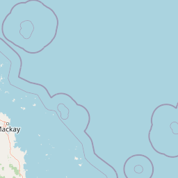
Map view of Brampton Islands National Park

Use this park location map to pinpoint Brampton Islands National Park in Australia, understand its exact geographic position, and read its mapped placement within the surrounding landscape more clearly.

Pigeon | © OpenStreetMap contributors

Location context for Brampton Islands National Park

Queensland
Park atlas

Explore related protected landscapes and marine environments across Queensland's central coast.

Discover More National Parks and Protected Areas Near Brampton Islands National Park in Queensland

Explore other national parks and protected areas geographically close to Brampton Islands National Park, including additional coastal islands, marine reserves, and regional conservation zones. Trace the mapped spread of protected landscapes in Queensland, compare diverse island ecosystems, and understand the broader conservation geography beyond a single park.
Marine protected areaQueensland
Park boundaries overlap#1 closest

North

Great Barrier Reef Marine Park: Atlas and Geographic Context for Queensland Protected Waters

Exploring the reef system and marine conservation zones in northeastern Australia

The Great Barrier Reef Marine Park stands as an internationally significant marine protected area. By spanning a massive stretch of the Queensland coast, this protected landscape provides a critical framework for marine governance and reef conservation. Users can examine the unique zoning and distribution of coral reef habitats that define this extensive tropical ecosystem.

Area
343,966 km²
Established
1975
Climate
Tropical
Scope
Marine
National parkQueensland
11 km away#2 closest

Northwest

Smith Islands National Park: Queensland Coastal Protected Area Map

Discover the mapped geography and island landscapes of North Queensland.

Smith Islands National Park represents a significant protected island landscape off the coast of Queensland, Australia. This page allows for detailed exploration of its geographic features, mapped boundaries, and role as a national park within the North Queensland region's atlas of natural areas. Understand the unique character of these tropical islands and their place within Australia's network of preserved coastal environments.

Area
18.7 km²
IUCN
II
Scope
Terrestrial
National parkQueensland
About 19 km away#3 closest

East

South Cumberland Islands National Park: Queensland's Dramatic Granite Island Protected Landscape

Explore its unique mapped geography and natural terrain.

South Cumberland Islands National Park, situated in Queensland, Australia, is a remarkable collection of islands characterized by dramatic granite landscapes, steep interior slopes cloaked in tropical rainforest, and surrounding coral fringing reefs. As the largest island, Scawfell Island rises to a prominent 397-metre peak, showcasing the island group's significant geological features and contributing to its distinct protected landscape identity within the Whitsunday region. Understanding this park offers insight into the mapped natural context of Australia's coastal protected areas.

Area
21.8 km²
IUCN
II
Relief
Mountain
Climate
Subtropical
National parkQueensland
23 km away#4 closest

West

Cape Hillsborough National Park: Queensland's Volcanic Peninsula National Park

Mapped geography and protected landscape context in Central Queensland.

Cape Hillsborough National Park is a notable protected area defined by its unique volcanic peninsula landform in Queensland. Its rugged terrain features dense rainforest interiors that contrast with the surrounding coastal environments and tidal zones. As a national park, it offers an excellent opportunity to study landscape context, mapped geological features, and the distribution of protected natural areas within the Central Queensland region.

Area
10.22 km²
Established
1985
IUCN
II
Relief
Upland
National parkQueensland
29 km away#5 closest

Southwest

Reliance Creek National Park: Preserving Queensland's Coastal Palm Forest Ecosystem

Mapped protected landscape on Queensland's central coast.

Reliance Creek National Park is a critical conservation site in Queensland, safeguarding the most significant remaining area of coastal palm forest. This compact national park protects a unique subtropical ecosystem that has largely vanished from the surrounding regional landscape. Users can explore its precise location and geographic context, understanding its importance as a preserved natural heritage and a testament to the original coastal plain environment.

Area
0.14 km²
Established
1980
IUCN
II
Access
Remote access
National parkQueensland
30 km away#6 closest

Northwest

Lindeman Islands National Park: Queensland National Park Atlas and Protected Landscape

Explore mapped boundaries and regional geography within Queensland.

Lindeman Islands National Park is a designated national park offering insights into Queensland's protected natural landscapes. This page provides an atlas-style exploration of its geographic scope, mapped terrain, and role as a protected area within the northeastern Australian region. Understand its setting and unique landscape character for informed geographic discovery.

Area
33.1 km²
IUCN
II
Relief
Lowland
Climate
Tropical
National parkQueensland
30 km away#7 closest

West

Newry Islands National Park: A Mapped Protected Landscape in Queensland's Atlas

Explore the geographic boundaries and regional context of this national park.

Newry Islands National Park is a significant protected area located within Queensland, Australia. As a national park, it serves as a crucial point for understanding the distribution of protected lands and the diverse geography of northeastern Australia. This page provides a focused view on its mapped landscape, allowing for detailed atlas-based exploration of its protected boundaries and regional setting. Engage with the specific geographic identity of this Queensland natural landscape.

Area
4.64 km²
Established
1938
IUCN
II
Climate
Tropical
National parkQueensland
35 km away#8 closest

Southwest

Pioneer Peaks National Park: Queensland National Park Geography and Mapped Boundaries

Explore its protected landscape and regional context.

Pioneer Peaks National Park represents a distinct protected area within Queensland, Australia, offering valuable insights into regional geography and mapped natural landscapes. This canonical page focuses on the park's identity as a national park, detailing its geographic setting and the significance of its protected boundaries. It serves as a crucial point for understanding its place within the Australian atlas and the broader context of conservation landscapes.

Area
18.4 km²
Established
1992
IUCN
II
Relief
Mountain

Common questions about visiting, size, designation, and location context for Brampton Islands National Park

Brampton Islands National Park FAQs for park facts, access, geography, and protected area context

Find quick answers about Brampton Islands National Park, including protected-area facts, park geography, trail and visitor context, and how the park fits into its surrounding country and regional landscape.
MoriAtlas Explorer

Continue Your Protected Areas Search Across the Global Atlas

Deepen your exploration by continuing the structured search for national parks and protected areas worldwide. Utilize the comprehensive filtering capabilities to compare different conservation landscapes and refine your understanding of global park geography. Discover more about the distribution and characteristics of protected natural areas.

Global natural geography