Mori Atlas logo
State or regional parkCeiba State Forest

Tracing the mapped boundaries and interconnected mangrove ecosystems of this vital Caribbean nature reserve

Ceiba State Forest: A Comprehensive Geographical Profile of Puerto Rico's Coastal Protected Landscape

(Bosque Estatal de Ceiba)

Ceiba State Forest encompasses a significant coastal wetland region along the eastern shores of Puerto Rico, featuring a rare concentration of all four native mangrove species. This protected landscape extends from dense tidal mangrove channels into sandy beach zones and vibrant coral reef systems. Our structured atlas data details the ecological connectivity of these coastal habitats and the regional geography that supports this essential nature reserve.

mangrovescoastal wetlandsbirdwatchingImportant Bird Areacoral reefsstate forest

Ceiba State Forest

State or regional park

Park overview

Structured park overview, official facts, and landscape profile for Ceiba State Forest

Ceiba State Forest park facts, protected area profile, and essential visitor context

Review the core facts for Ceiba State Forest, including designation, size, terrain, visitor scale, habitats, and operating context in one park-focused overview.

About Ceiba State Forest

Ceiba State Forest, sometimes referred to together with its Ceiba Nature Reserve designation, is a coastal protected area on the eastern shore of Puerto Rico. The forest sits at low elevation near sea level and stretches across parts of two municipalities, Ceiba and Fajardo. Its geography is shaped by the meeting of mangrove wetlands, sandy beaches, and fringing coral reef systems, creating a layered coastal environment where marine and terrestrial habitats are tightly interwoven.

The mangrove forest dominates the reserve, covering roughly 95 percent of the ground. Soils across most of the site are characterized as marsh or wetland soils, with high salinity and acidity due to constant or seasonal saltwater influence. In the beach areas, soils shift to lomic sandy substrates, while slightly higher sections of the forest show loamy clay silt. These soil patterns reflect the transitional nature of the land between open sea, tidal inlet, and dry land.

Within the forest and reserve boundaries, additional protected zones fall under the stewardship of the Conservation Trust of Puerto Rico, including the Medio Mundo y Daguao Protected Natural Area. Playa Los Machos, a white sand beach known for snorkeling, sits within the reserve and represents the recreational face of a landscape whose deeper identity is ecological. The site's combination of forest, wetland, beach, and reef has made it a focal point for conservation in eastern Puerto Rico.

Quick facts and research context for Ceiba State Forest

Ceiba State Forest occupies about 350 acres along the eastern coast of Puerto Rico. It lies in the municipalities of Ceiba and Fajardo. The reserve is dominated by mangrove forest and is flanked by sandy beaches and coral reefs. Its elevation sits close to sea level. The site is administered by the Puerto Rico Department of Natural and Environmental Resources. Certain areas within its boundaries are managed by the Conservation Trust of Puerto Rico as the Medio Mundo y Daguao Protected Natural Area.

Protection and recognition

Examine the documented protection scope and management framework for this protected area.

Ceiba State Forest Protection Status and International Recognition Records

Ceiba State Forest maintains a documented mixed protection scope within its regional conservation boundaries. Verified administrative records outline the official status and international recognition framework associated with the reserve.

Protection details

Protection scope
Mixed
Transboundary protection
No
Park context

Deeper park guide and search-rich context for Ceiba State Forest

Ceiba State Forest history, landscape, wildlife, and travel context

Explore Ceiba State Forest through its history, landscape character, ecosystems, wildlife, conservation priorities, cultural context, and seasonal travel timing in a structured park guide built for atlas discovery and search intent.

Why Ceiba State Forest stands out

Ceiba State Forest is best known for hosting all four mangrove species found in Puerto Rico, forming a dense coastal wetland that is rare in its completeness on the island. It is recognized as an Important Bird Area, drawing both resident species such as the endangered yellow-shouldered blackbird and a wide variety of migratory birds, alongside occasional Caribbean flamingos. The reserve's combination of mangrove forest, white-sand beach, and adjacent coral reef makes it a compact example of interconnected Caribbean coastal ecosystems.
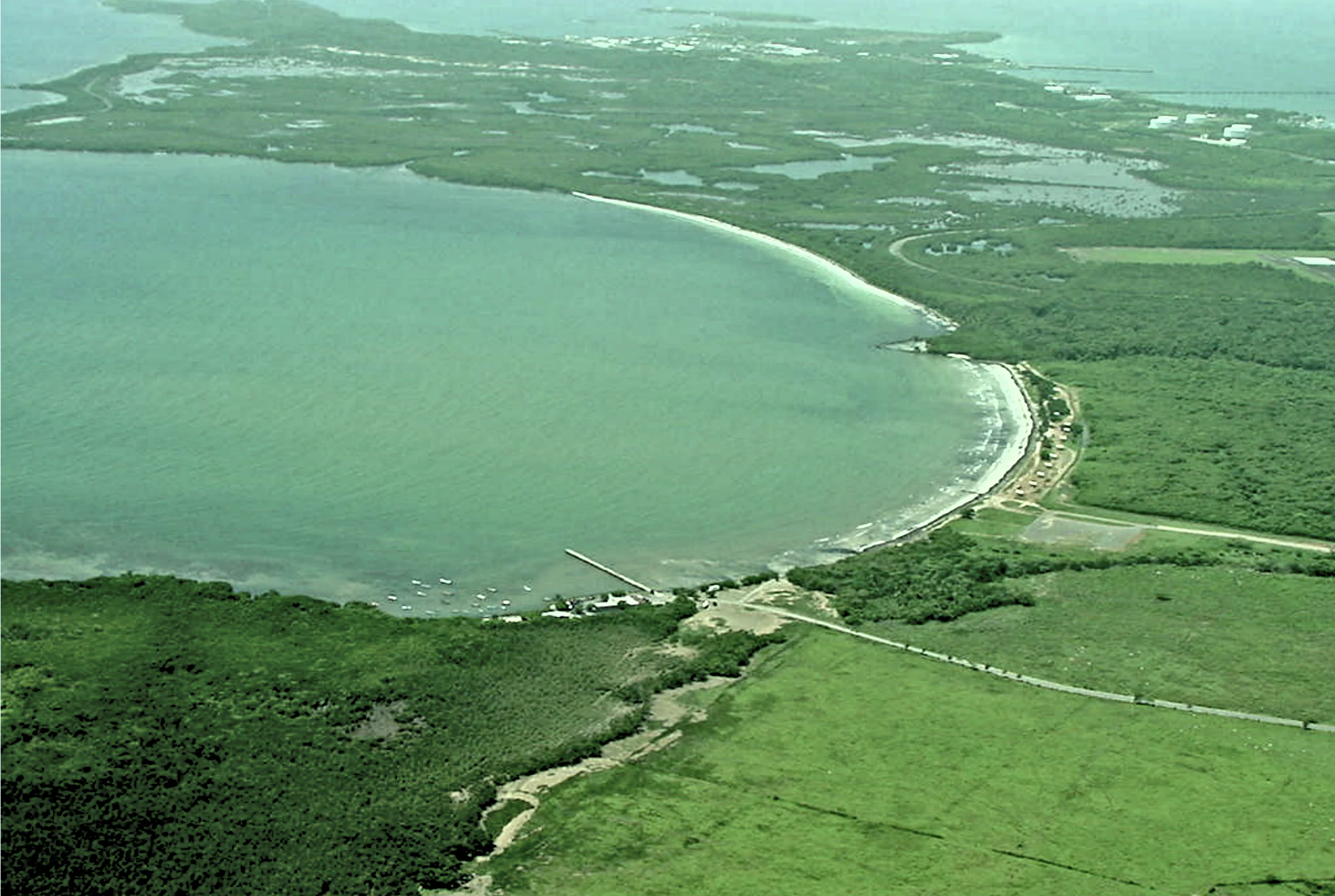
Aerial photograph of a coastal landscape featuring a large curved lagoon with turquoise-green water, a sandy beach shoreline, dense green mangrove forest, and a coastal road running along the shore
Aerial view of Ceiba State Forest Natural Reserve showing the curved coastline, lagoon, and surrounding mangrove forest in Puerto Rico

Ceiba State Forest history and protected-area timeline

The ecological significance of what is now Ceiba State Forest was first formally acknowledged in 1918, when Puerto Rico governor Arthur Yager proclaimed more than 800 acres of coastal mangrove forest between the municipalities of Fajardo and Naguabo as protected. This early designation set the foundation for later conservation efforts along Puerto Rico's eastern shoreline.

In 1941, a large portion of the proclaimed mangrove zone was transferred from the Puerto Rican government to the federal government of the United States for the development of Roosevelt Roads Naval Station. The loss of this land reduced the protected area, but the remaining mangrove forest continued to be recognized for its biological and cultural value. In 1979, the Puerto Rico Department of Natural and Environmental Resources designated the surviving portion as an irreplaceable forest reserve through executive order, citing its biological, cultural, and historical importance.

Following the eventual closure of Roosevelt Roads, efforts emerged to integrate parts of the former naval station and the Punta Figueras area into the broader state forest. The forest's importance to regional biodiversity was reaffirmed in 2007 when BirdLife International recognized it as an Important Bird Area. The reserve portion of the forest is classified internationally as a strict nature reserve, highlighting the high level of protection applied to its mangrove ecosystems.

Ceiba State Forest landscape and geographic character

Ceiba State Forest occupies a low-lying coastal landscape at just a few meters above sea level. Its terrain is dominated by mangrove wetlands, with the forest floor submerged or saturated for much of the year. The visual character of the reserve is shaped by dense stands of mangrove that fringe tidal channels and brackish water, transitioning outward into sandy beaches and the shallow reef environments along the coast.

Soils across most of the reserve consist of argillaceous, saline, and organic wetland substrates, with lomic sandy soils in the beach zones and loamy clay silt on slightly elevated portions of the forest. These conditions maintain an acidic, saline environment that defines the vegetation pattern of the area.

The climate supports this coastal mangrove setting. Average annual precipitation is around 1,312 millimeters, with the driest month typically February and the most humid period running from May through September. Average temperatures remain warm throughout the year, near 26 degrees Celsius, reinforcing the tropical maritime character of the landscape.

Ceiba State Forest ecosystems, habitats, and plant life

Ceiba State Forest preserves one of the most complete mangrove ecosystems in Puerto Rico, hosting all four mangrove species native to the island. Red mangrove, black mangrove, white mangrove, and buttonwood each occupy their characteristic tidal zones, creating a structurally diverse wetland that performs essential functions in shoreline stabilization, water filtration, and nursery habitat production.

Alongside the mangroves, saltwort is common in the reserve, and seagrass meadows thrive in the maritime zones. These seagrass beds provide both food and shelter for a wide variety of marine animals and act as an extension of the wetland system into the nearshore waters. Together, the mangrove, seagrass, and reef environments form a connected coastal mosaic rather than a series of isolated habitats.

Vegetation is sparser in the salt marsh areas, where salt accumulation limits plant cover. This natural pattern contributes to the reserve's ecological diversity, allowing open marsh zones to support different species communities than the dense mangrove canopy further inland.

Ceiba State Forest wildlife and species highlights

The mangrove forests of Ceiba State Forest provide habitat for a rich mix of fish, crustaceans, and birds, functioning as a productive coastal ecosystem. The reserve is particularly notable for its birdlife, which helped earn it Important Bird Area recognition. Resident bird species include the Bahama pintail, the West Indian whistling duck, and the endangered yellow-shouldered blackbird, whose presence adds special conservation value to the site.

A wide variety of migratory birds, including both breeding and non-breeding populations, use the reserve during seasonal movements. The forest's surrounding marine and wetland areas also support the West Indian manatee, a species still classified as endangered in Puerto Rico. Researchers from the University of Puerto Rico at Humacao have noted the increasing frequency of Caribbean flamingos in the reserve in recent years, viewing their return as a promising sign of the revitalization of coastal wetlands that once supported large flocks.

Ceiba State Forest conservation status and protection priorities

Ceiba State Forest holds a central place in the conservation of coastal wetland ecosystems in Puerto Rico. The reserve portion is classified as a strict nature reserve under international standards, reflecting the high level of protection applied to its mangrove habitats and the biodiversity they support.

Recognition as an Important Bird Area by BirdLife International underscores the reserve's role in safeguarding bird populations, including endangered resident species and migratory visitors that rely on the mangrove forests and adjacent coastal waters. The site's combination of mangrove, reef, and seagrass habitats makes it a key area for protecting the ecological processes that sustain nearshore marine life in eastern Puerto Rico.

The continued involvement of the Conservation Trust of Puerto Rico through management of the Medio Mundo y Daguao Protected Natural Area within the forest's boundaries adds a layer of stewardship focused on long-term ecological recovery. Post-naval-station conversations about integrating former military and Punta Figueras lands into the reserve also reflect a broader push to expand and reinforce conservation protections across this coastal landscape.

Ceiba State Forest cultural meaning and human context

The mangrove forests that form Ceiba State Forest have been part of Puerto Rico's coastal identity for over a century. Their formal protection began in 1918 under Governor Arthur Yager, and the landscape has since carried both ecological and cultural weight for the surrounding communities of Ceiba and Fajardo. The overlap of conservation history and regional identity gives the forest a meaningful place in the story of eastern Puerto Rico.

Top sights and standout views in Ceiba State Forest

Ceiba State Forest stands out for the completeness of its mangrove ecosystem, including all four mangrove species native to Puerto Rico. It is a recognized Important Bird Area supporting resident, migratory, and increasingly reintroduced species such as the Caribbean flamingo. The reserve combines mangrove wetlands, sandy beaches, and coral reef habitats into a single protected coastal unit, while also incorporating additional conservation zones managed by the Conservation Trust of Puerto Rico.

Best time to visit Ceiba State Forest

Ceiba State Forest has a warm tropical climate year-round, with average temperatures near 26 degrees Celsius. The driest month is typically February, offering a relatively calm period in the wetland, while the May to September wet season brings the highest humidity and the heaviest rainfall. For visitors interested in birdlife, periods that overlap with migratory seasons can offer rich viewing, while the drier months may make coastal walks and snorkeling at Playa Los Machos more comfortable.
Monthly climate preview

Examine long-term representative temperature and precipitation averages across the year

Ceiba State Forest Climate Normals and Annual Weather by Month

Representative coordinate records show average monthly temperatures ranging from 25.17 °C to 28.14 °C alongside recorded precipitation values between 2.06 and 6.49 mm per day. Detailed monthly breakdowns provide complete long-term climate normals for evaluating historical environmental conditions.
Annual mean27 °C
25 °C28 °C
Jan25°
Feb25°
Mar25°
Apr26°
May27°
Jun28°
Jul28°
Aug28°
Sep28°
Oct28°
Nov27°
Dec26°
Warmest month
August

28.1 °C

Coolest month
February

25.2 °C

Wettest month
September

6.5 mm/day

Driest month
February

2.1 mm/day

Park location guide

Geography guide, regional context, and park location map for Ceiba State Forest

Ceiba State Forest park geography, regions, and map view in United States of America

Understand where Ceiba State Forest sits in United States of America through a broader geographic reading of the surrounding landscape, nearby location context, and its mapped position within the national park landscape.

How Ceiba State Forest fits into United States of America

The United States of America is a federal presidential republic and one of the world's largest countries by area and population. It consists of 50 states across a vast territory spanning multiple time zones, with its capital in Washington, D.C. and largest city in New York City. The nation has a diverse economy, influential political system, and significant cultural and military presence globally.

Wider geography shaping Ceiba State Forest in United States of America

The United States occupies a vast territory in North America, bordered by Canada to the north and Mexico to the south. The 48 contiguous states stretch from the Atlantic to the Pacific Ocean, while Alaska occupies the northwestern region and Hawaii is an archipelago in the Pacific. The country encompasses diverse terrain including the Rocky Mountains, Appalachian Mountains, Great Plains, and extensive river systems.

Map view of Ceiba State Forest

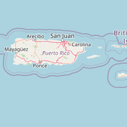
Use this park location map to pinpoint Ceiba State Forest in United States of America, understand its exact geographic position, and read its mapped placement within the surrounding landscape more clearly.

Pigeon | © OpenStreetMap contributors

Location context for Ceiba State Forest

Puerto Rico

Explore protected wetland habitats, tidal channels, and coastal reef environments through detailed field photography.

Ceiba State Forest Photos and Scenery: Visualizing Coastal Mangrove Landscapes

Visual documentation captures the dense mangrove stands and tidal channels that define the low-lying coastal terrain of eastern Puerto Rico. Examining these protected habitats provides clear visual context for the interconnected wetland ecosystems and avian birding reserves found across the region.

Aerial photograph of a coastal landscape featuring a large curved lagoon with turquoise-green water, a sandy beach shoreline, dense green mangrove forest, and a coastal road running along the shore

Park atlas

Compare regional coastal reserves and protected landscapes across eastern Puerto Rico.

Other Parks and Protected Areas Near Ceiba State Forest

Browsing other parks near Ceiba State Forest reveals connected coastal wetlands, mangrove ecosystems, and marine reserves across the region. Regional park comparison provides deeper context into eastern Puerto Rico habitats and surrounding conservation zones.
Watercolor painting of a coastal landscape with green hills, wetlands, and distant mountains in a soft palette.
State or regional parkLoíza
About 38 km away#1 closest

West

Piñones State Forest: Mapped Geography and Protected Coastal Terrain in Loíza, Puerto Rico

Coastal mangrove reserve and protected forestland

Piñones State Forest is a significant protected area on the northern coast of Puerto Rico. This reserve features a low-lying landscape defined by intricate mangrove systems, coastal dunes, and rare endemic plant populations. Its proximity to the San Juan metropolitan area provides an important ecological buffer, offering a unique opportunity to map and study the intersection of Caribbean coastal woodlands and protected natural boundaries.

Relief
Lowland
Climate
Tropical
Access
Easy access
Scope
Terrestrial
State or regional parkSan Juan
About 50 km away#2 closest

West

San Patricio State Forest: Protected Urban Karst and Mogote Terrain in San Juan

Mapping subtropical moist forest geography in Puerto Rico

San Patricio State Forest represents a unique conservation success as a reclaimed secondary forest within the San Juan metropolitan region. This protected area maintains the distinctive karst geology of Puerto Rico, featuring a prominent mogote landmark that provides habitat for endemic species and native plant communities amidst an urban environment.

Area
0.283 km²
Established
2000
Relief
Upland
Climate
Tropical
Watercolor painting of a tropical mountain landscape with lush vegetation and palm trees in the foreground and rolling hills in the background.
State or regional parkPuerto Rico
About 51 km away#3 closest

Southwest

Carite State Forest: Volcanic Mountain Geography and Protected Watersheds in Puerto Rico

Mapping the Sierra de Cayey ecosystem and river headwaters.

Carite State Forest protects 2,600 hectares of rugged, volcanic mountain landscape in southeastern Puerto Rico. Known for its subtropical moist forest and high-elevation dwarf zones, the terrain provides a critical habitat for rare endemic species. The forest serves as a vital hydrological watershed, sustaining regional river systems through its complex network of ravines and forested mountain slopes.

Area
26 km²
Established
1935
Relief
Mountain
Climate
Tropical
State or regional parkPuerto Rico
About 71 km away#4 closest

Southwest

Aguirre State Forest: Protected Coastal and Mangrove Geography in Southern Puerto Rico

Explore the estuarine terrain and tidal salt pond boundaries.

Aguirre State Forest encompasses a protected coastal mosaic of mangrove forests and salt-tolerant vegetation across the southern coast of Puerto Rico. This record outlines the forest's role as a primary node in the Jobos Bay estuarine system, characterized by low lying tidal channels and hypersaline flats that provide habitat for diverse avian and marine species within its protected borders.

Area
9.68 km²
Established
1918
Relief
Lowland
Climate
Tropical
National parkUnited States of America
About 73 km away#5 closest

East

Virgin Islands National Park: Protected Landscape Atlas and Geographic Context

Explore volcanic terrain, tropical rainforests, and protected marine ecosystems.

Virgin Islands National Park offers an atlas-style view of protected Caribbean landscapes. The park encompasses volcanic uplands, dense tropical rainforests, and extensive coral reef systems surrounding Saint John island. Discover the mapped boundaries and geographic features that define this significant national park, providing crucial context for its unique ecosystems and historical significance.

Area
59.64 km²
Established
1956
IUCN
V
Visitors
112.3K annual
State or regional parkPuerto Rico
About 97 km away#6 closest

West

Los Tres Picachos State Forest: A Geographic Guide to Puerto Rico's Mountain Protected Areas

Cloud forests, volcanic terrain, and watershed protection

Los Tres Picachos State Forest encompasses a striking landscape in the Puerto Rican interior, marked by deep river valleys and its namesake triple peaks. This atlas feature provides insights into the forest's layered ecological zones and its role as a crucial hydrological anchor for the Toro Negro and Cialitos river systems within the Cordillera Central.

Established
1999
Relief
Mountain
Climate
Tropical
Access
Remote access
A wide watercolor illustration showing a forest scene with trees in the foreground, a winding path or river, and green hills in the background.
Nature reservePuerto Rico
About 103 km away#7 closest

West

Cambalache Forest Reserve: A Detailed Look at Northern Puerto Rico Karst Geography

Protected karst landscape and forest mosaic

Focusing on the rugged limestone mogotes that define the Northern Karst Belt, Cambalache Forest Reserve serves as a vital protected area for endemic flora and fauna. This record provides geographic context on its low-elevation forest structure, the ecological significance of its varied microclimates, and its role as a persistent research site since the mid-twentieth century.

Established
1943
Relief
Upland
Access
Easy access
Scope
Terrestrial
Watercolor painting of a hilly, green landscape featuring rolling mountains in the distance and vegetation in the foreground.
State or regional parkUnited States of America
About 104 km away#8 closest

West

Cerrillos State Forest: Protected Subtropical Woodland and Reservoir Geography

Foothill landscapes and watershed features in Ponce, Puerto Rico

This protected area features a mix of tabonuco forest and water-based recreational terrain. Spanning the slopes of the Cordillera Central foothills, the forest encompasses the Cerrillos River and the man-made Lake Cerrillos reservoir, offering a distinct example of subtropical moist forest ecology within the United States commonwealth system.

Area
0.79 km²
Established
1996
Relief
Upland
Climate
Subtropical

Common questions about visiting, size, designation, and location context for Ceiba State Forest

Ceiba State Forest FAQs for park facts, access, geography, and protected area context

Find quick answers about Ceiba State Forest, including protected-area facts, park geography, trail and visitor context, and how the park fits into its surrounding country and regional landscape.
MoriAtlas Explorer

Continue Your Protected Areas Search Across the Global Atlas

Deepen your exploration by continuing the structured search for national parks and protected areas worldwide. Utilize the comprehensive filtering capabilities to compare different conservation landscapes and refine your understanding of global park geography. Discover more about the distribution and characteristics of protected natural areas.

Global natural geography