Mori Atlas logo
Protected landscapeCiężkowicko-Rożnowski Park Krajobrazowy

Mapping the sandstone rock formations, forested ridges, and mineral springs of the Małopolska region

Ciężkowicko-Rożnowski Park Krajobrazowy: A Protected Landscape in the Carpathian Foothills

Located in the heart of Lesser Poland Voivodeship, Ciężkowicko-Rożnowski Park Krajobrazowy protects a transition zone between the Carpathian mountains and the northern lowlands. The landscape is defined by its flysch geology, featuring prominent sandstone rock outliers such as the Skamieniałe Miasto reserve, steep-sided river valleys, and deeply partitioned ridges covered in ancient beech forests. This protected area offers an intricate look at the ecological and geological character of the Polish foothill regions.

landscape parkCarpathian foothillsPogórze RożnowskiePogórze Ciężkowickiesandstone rock formationsSkamieniałe Miasto
A flat-style vector illustration of a hiking trail with wooden stairs winding past large pink sandstone rock formations through a green forest.

Ciężkowicko-Rożnowski Park Krajobrazowy

Protected landscape

Park overview

Structured park overview, official facts, and landscape profile for Ciężkowicko-Rożnowski Park Krajobrazowy

Ciężkowicko-Rożnowski Park Krajobrazowy park facts, protected area profile, and essential visitor context

Review the core facts for Ciężkowicko-Rożnowski Park Krajobrazowy, including designation, size, terrain, visitor scale, habitats, and operating context in one park-focused overview.

About Ciężkowicko-Rożnowski Park Krajobrazowy

Ciężkowicko-Rożnowski Park Krajobrazowy is a protected foothill landscape in southern Poland, stretching across the Pogórze Rożnowskie and Pogórze Ciężkowickie ranges in Małopolska. It occupies the transition zone between the lowlands of southern Poland and the Carpathian mountain system, a position that gives the park its characteristic combination of rolling ridges, narrow stream valleys, deeply cut gullies, and isolated rock crags.

The landscape is built predominantly from flysch, the layered sequence of sandstones and shales typical of the Carpathian foreland. Soft shales erode easily, while harder sandstone layers weather into striking outliers and rock cities that give the region its distinctive scenery. The most famous of these is Skamieniałe Miasto near Ciężkowice, complemented by the Diable Skały group near Bukowiec, the Wieprzek rock in Siekierczyna, and the small Wodospad gorge. Together, these formations create a varied terrain of cliffs, rock walls, and stone rubble slopes that supports both specialist flora and geological heritage.

Forested terrain dominates the park. Although forestry has been practiced here for generations, the woodlands retain an unusually high degree of natural character. Stands of old trees are widespread, and the vegetation includes acidophilous mountain beech forest, fertile Carpathian beech forest, and rare thermophilous grassland patches on warm southern slopes. The result is a richly layered mosaic of forest communities that transition with elevation and exposure across the foothills.

Ecologically, the park is notable for its biodiversity. Around 900 vascular plant species have been recorded, including roughly 40 protected species such as the southern bladdernut, ostrich fern, giant horsetail, and several clubmosses. The fauna includes protected birds like the black stork, several owl and woodpecker species, and a strong bat community that includes the lesser horseshoe bat and the large mouse-eared bat. Reptiles such as the slow worm and amphibians such as the fire salamander add to the park's faunal interest.

Established in 1995 and managed by the regional landscape park authority of Małopolska, the park functions as a buffer between the more heavily used Carpathian landscapes further south and the agricultural lowlands to the north. With its reserves, environmental education center at Polichty, marked hiking trails, and proximity to the Dunajec river valley, the park serves as both a conservation area and an accessible destination for discovering the quieter side of the Polish foothills.

Quick facts and research context for Ciężkowicko-Rożnowski Park Krajobrazowy

Ciężkowicko-Rożnowski Park Krajobrazowy lies in southeastern Małopolska, spanning the Pogórze Rożnowskie and Pogórze Ciężkowickie mesoregions. It was established on 16 November 1995 by order of the Tarnów voivode and is managed by the Zespół Parków Krajobrazowych Województwa Małopolskiego. Within its boundaries are two nature reserves, including the well-known Skamieniałe Miasto reserve near Ciężkowice, and a large network of landscape and natural monuments.

The park protects foothills built mainly from Carpathian flysch, with valleys cut into soft shales and sandstones. Mineral water springs, including sulphide and chloride sources, add to the geological identity of the area. Despite long-standing forestry activity, the forests retain a high degree of natural character, with significant stands of old-growth trees and rich understory vegetation.

Protection and recognition

Documented terrestrial protection scope, management framework, and official recognition records

Ciężkowicko-Rożnowski Park Krajobrazowy Protection Status and Regional Recognition Data

Ciężkowicko-Rożnowski Park Krajobrazowy maintains a documented terrestrial protection status within its regional landscape. Structured records detail the established management scope and international recognition frameworks associated with the protected area.

Protection details

Protection scope
Terrestrial
Transboundary protection
No
Park context

Deeper park guide and search-rich context for Ciężkowicko-Rożnowski Park Krajobrazowy

Ciężkowicko-Rożnowski Park Krajobrazowy history, landscape, wildlife, and travel context

Explore Ciężkowicko-Rożnowski Park Krajobrazowy through its history, landscape character, ecosystems, wildlife, conservation priorities, cultural context, and seasonal travel timing in a structured park guide built for atlas discovery and search intent.

Why Ciężkowicko-Rożnowski Park Krajobrazowy stands out

The park is especially known for its dramatic sandstone rock formations and outliers that rise from the forested foothills, most famously the Skamieniałe Miasto, or 'Petrified City', reserve near Ciężkowice with its cluster of weathered rock towers. Equally distinctive are the surrounding natural beech forests of the Carpathian foothills, including acidophilous and fertile beech communities, and the xerothermic grasslands that cling to sun-exposed slopes. The park also stands out for the surprising naturalness of its woodlands, shaped both by flysch geology and by a long forest tradition that nonetheless preserved a high share of old-growth trees. Mineral springs, protected bat species, and a network of reserves and natural monuments further anchor the park's identity as one of the most geologically and ecologically varied foothill parks of Małopolska.
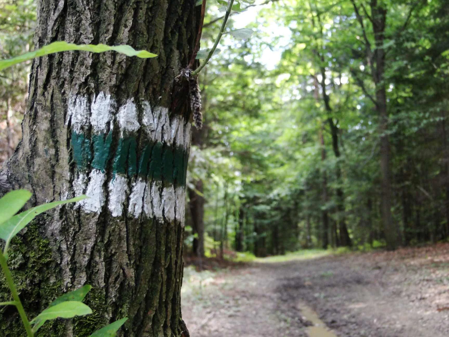
A close-up view of a tree trunk with a painted green and white trail marker; a dirt path continues into the blurred forest background.
A marked hiking trail winds through the forest in Ciężkowicko-Rożnowski Landscape Park.

Ciężkowicko-Rożnowski Park Krajobrazowy history and protected-area timeline

The area that today forms Ciężkowicko-Rożnowski Park Krajobrazowy has a long history of human use, particularly forest management, agricultural settlement, and small-scale extraction of local resources. Despite these pressures, much of the woodland retained old-growth characteristics, and by the late twentieth century there was growing recognition that the geological, landscape, and ecological values of the foothills deserved formal protection.

The park was formally established on 16 November 1995 through Regulation No. 13/95 of the voivode of Tarnów. Its creation reflected the broader movement in Poland during the 1990s to formalize the protection of the Carpathian foothills as landscape parks, balancing conservation with continued rural and forestry use. The neighboring Obszar Chronionego Krajobrazu Pogórza Ciężkowickiego was designated to serve as a protective buffer zone around the park.

Administration of the park later passed to the Zespół Parków Krajobrazowych Województwa Małopolskiego, which now oversees its conservation, educational, and cultural work. An Environmental Education Center was developed in the village of Polichty in Gmina Gromnik to support interpretation of the park's natural and geological heritage. Over the following decades, the park's trail network was expanded, including the Green Trail between Piaski-Drużków and Ruda Kameralna, strengthening its role as a destination for quiet landscape exploration in the Małopolska foothills.

Ciężkowicko-Rożnowski Park Krajobrazowy landscape and geographic character

The physical landscape of Ciężkowicko-Rożnowski Park Krajobrazowy is shaped by the foothills of the Pogórze Rożnowskie and Pogórze Ciężkowickie, a transitional terrain between the Carpathian mountains to the south and the lowlands of Małopolska to the north. The underlying geology is dominated by flysch, with alternating layers of sandstones and shales. The more resistant sandstone forms the elevated ridges and isolated crags, while softer shales have been carved by erosion into numerous valleys, gullies, and stream channels.

The most visually distinctive elements of the landscape are the rock outliers that rise abruptly from the forested slopes. The Skamieniałe Miasto near Ciężkowice, with its dense cluster of sandstone pillars, towers, and chambers, is the park's signature landform. Adjoining it lie the Diable Skały near Bukowiec, the Wieprzek rock at Siekierczyna, and the narrow Wodospad gorge in Ciężkowice. These formations give the park a varied terrain of cliffs, stone walls, rubble slopes, and sheltered pockets of microclimate.

Drainage is organized around a network of small Carpathian streams that cut deep, often steep-sided valleys into the flysch. Along these valleys, mineral water springs emerge, including sulphide and chloride sources such as the Paweł, Jacek, and Geologów springs, adding a further element of geological variety. The overall impression is of a moderate, deeply partitioned foothill landscape, with elevations low enough for comfortable hiking but varied enough to support a wide range of habitats.
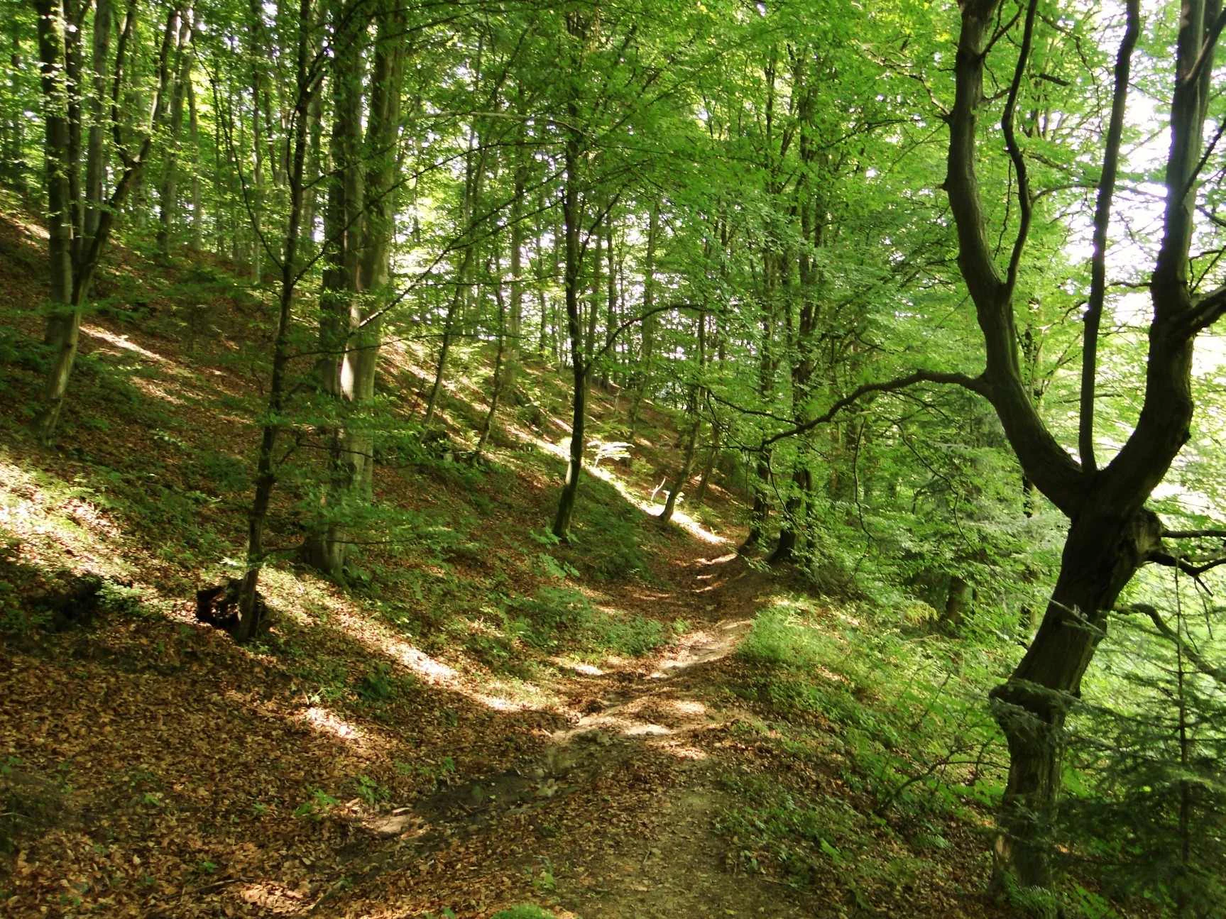
Dirt trail running through a deciduous forest with tall trees, lush green canopy, and dappled sunlight falling on a leaf-littered slope.
A shaded footpath winds uphill through a dense deciduous forest, with sunlight filtering through the green canopy onto the leaf-covered slope.

Ciężkowicko-Rożnowski Park Krajobrazowy ecosystems, habitats, and plant life

Ecologically, the park represents one of the better-preserved foothill woodland complexes in the Carpathian foothills of southern Poland. The dominant ecosystems are forests, ranging from acidophilous mountain beech communities on poorer soils to fertile Carpathian beech forests on richer substrates. These communities form a continuous mosaic across the ridges and valleys, with the understory varying by aspect, slope, and soil depth.

Among the most valued plant communities are the acidophilous beech forests of the Jamna area and the Mogiła ridge, the fertile Carpathian beech forests around Jamna, Borowa, Siekierczyna, Bruśnik, and Sucha Góra, and the xerothermic grasslands that cling to the warm, sun-exposed slopes above the Biała valley. These thermophilous swards host specialized plants adapted to dry conditions and represent an important, increasingly rare habitat type in the region.

Approximately 900 vascular plant species have been documented in the park, of which around 40 are legally protected. Notable species include the southern bladdernut, the broad-leaved marsh orchid, the towering cowslip, the ostrich fern, the hard fern, the giant horsetail, and several clubmosses. Nationally noteworthy lichen communities of the fir and becker thread lichens also occur, and the Styr nature reserve protects valuable habitats around Zakliczyn that contribute significantly to the park's overall ecological coherence.

Ciężkowicko-Rożnowski Park Krajobrazowy wildlife and species highlights

The park's fauna reflects the richness of its mixed foothill habitats. Forests provide shelter for several protected mammal species, including the forest dormouse and the hazel dormouse, while bats are particularly well represented. Colonies of the lesser horseshoe bat and the large mouse-eared bat are among the park's most notable mammalian features, reflecting the value of old trees, caves, and rock shelters as roosting sites.

Birds are diverse, with the forest supporting black storks, tawny owls, Eurasian pygmy owls (notably within the Styr reserve), sparrowhawks, and multiple woodpecker species including the black, green, and grey-headed woodpeckers. Reptiles and amphibians are also present, with species such as the sand lizard, the fire salamander, the grass snake, and the slow worm inhabiting forest streams, rocky slopes, and damp undergrowth.

The combination of old-growth forest structure, varied topography, mineral springs, and protected rock formations creates diverse microhabitats that allow a wide range of species to coexist. For a foothill park of this size, the diversity and the proportion of legally protected species are particularly strong.

Ciężkowicko-Rożnowski Park Krajobrazowy conservation status and protection priorities

From a conservation perspective, Ciężkowicko-Rożnowski Park Krajobrazowy plays an important role in protecting the natural and landscape values of the Carpathian foothills in Małopolska. Its combined protection of geology, forests, and habitats makes it a key node in the regional network of protected areas. The two nature reserves within the park, Skamieniałe Miasto and Styr, anchor the formal protection of the most sensitive sites, including unique sandstone formations and rare plant and animal habitats.

The surrounding Obszar Chronionego Krajobrazu Pogórza Ciężkowickiego functions as a buffer zone, reducing the intensity of land use around the park and helping to maintain ecological connectivity with neighboring landscapes. The park's long forest tradition, surprisingly, has contributed to conservation by preserving a high proportion of old-growth stands, which in turn support specialist species such as certain bats, owls, lichens, and saproxylic insects.

The park's conservation program also emphasizes environmental education, centered at the Polichty facility, and integration with the broader management of Małopolska's landscape parks. Together, these efforts work to maintain the park's forest, rock, and grassland heritage for future generations while keeping the area accessible for low-impact recreation and scientific study.

Ciężkowicko-Rożnowski Park Krajobrazowy cultural meaning and human context

The park's territory has a long tradition of foothill settlement, with villages such as Ciężkowice, Zakliczyn, Rzepiennik Strzyżewski, Gromnik, and Czchów shaping the cultural landscape around the protected area. Small-scale farming, forestry, and local crafts have all left their mark on the surrounding region, and the names of nearby hamlets, trails, and local landmarks carry a sense of deep-rooted foothill heritage.

The dramatic rock formations have long been part of local folklore, with names such as Skamieniałe Miasto, or 'Petrified City', and Diable Skały, meaning 'Devil's Rocks', reflecting centuries of stories and legends attached to the landscape. Mineral springs have also shaped local identity, with sources such as Paweł and Jacek closely associated with regional traditions of health and pilgrimage. The Environmental Education Center at Polichty represents a more recent cultural contribution, linking local communities with the park's natural and geological heritage through interpretive programs and visitor outreach.

Top sights and standout views in Ciężkowicko-Rożnowski Park Krajobrazowy

Among the park's standout features, the Skamieniałe Miasto reserve near Ciężkowice stands as its most iconic landscape, a dense cluster of sandstone pillars and rock towers that defines the visual image of the entire protected area. The neighboring Diable Skały, Wieprzek rock, and Wodospad gorge add depth and variety to the park's geological story.

Equally important are the park's beech forests, both acidophilous and fertile forms, which together form one of the better-preserved foothill woodland complexes in the Carpathian foreland. Xerothermic grasslands, mineral springs, valuable lichen communities, and significant bat populations complete a park whose distinctiveness lies in the interaction between stone, forest, and water across the gentle ridges of the Małopolska foothills.

Best time to visit Ciężkowicko-Rożnowski Park Krajobrazowy

The park is enjoyable across much of the year, but late spring and early autumn are particularly rewarding seasons. In late spring, the beech forests are fresh and luminous, and the grasslands and rock outcrops come alive with flowering plants, while early autumn brings warm light, stable weather, and a rich display of forest color that emphasizes the contours of the foothills.

Summer offers full access to hiking trails and the longest daylight hours, though temperatures can be warm on exposed slopes such as the xerothermic grasslands above the Biała valley. Winter can also be appealing for visitors seeking quiet forest atmosphere, with snow often lingering on the ridges and rock formations, although conditions on steeper trails can be more demanding. As a foothills park rather than a high-mountain reserve, the seasonal character is gentle and varied rather than extreme.


Monthly climate preview

Long-term monthly temperature and precipitation normals for this protected landscape

Ciężkowicko-Rożnowski Park Krajobrazowy Climate and Annual Temperature Rhythm

Representative coordinates reveal measured monthly temperature shifts alongside consistent precipitation patterns across the year. Detailed monthly climate normals provide deeper insight into long-term environmental averages for this region.
Annual mean8 °C
-3 °C20 °C
Jan-3°
Feb-2°
Mar
Apr
May14°
Jun18°
Jul20°
Aug20°
Sep14°
Oct
Nov
Dec-2°
Warmest month
July

19.8 °C

Coolest month
January

-3.3 °C

Wettest month
July

3.4 mm/day

Driest month
December

1.3 mm/day

Park location guide

Geography guide, regional context, and park location map for Ciężkowicko-Rożnowski Park Krajobrazowy

Ciężkowicko-Rożnowski Park Krajobrazowy park geography, regions, and map view in Poland

Understand where Ciężkowicko-Rożnowski Park Krajobrazowy sits in Poland through a broader geographic reading of the surrounding landscape, nearby location context, and its mapped position within the national park landscape.

How Ciężkowicko-Rożnowski Park Krajobrazowy fits into Poland

Poland, officially the Republic of Poland, is a Central European country spanning from the Baltic Sea in the north to the Carpathian Mountains in the south. It borders Germany, Czech Republic, Slovakia, Ukraine, Belarus, Lithuania, and Kaliningrad Oblast. The country has a temperate climate, diverse landscapes, and is known for its rich history, cultural heritage, and strong economic position within the EU.

Wider geography shaping Ciężkowicko-Rożnowski Park Krajobrazowy in Poland

Poland occupies 312,696 km2 in Central Europe, extending from the Baltic Sea coast in the north to the Sudetes and Carpathian Mountains in the south. It borders Germany to the west, Czech Republic and Slovakia to the south, Ukraine and Belarus to the east, and Lithuania and Kaliningrad Oblast to the northeast. The landscape includes lowland plains, uplands, and mountain ranges.

Map view of Ciężkowicko-Rożnowski Park Krajobrazowy

Use this park location map to pinpoint Ciężkowicko-Rożnowski Park Krajobrazowy in Poland, understand its exact geographic position, and read its mapped placement within the surrounding landscape more clearly.

Pigeon | © OpenStreetMap contributors

Location context for Ciężkowicko-Rożnowski Park Krajobrazowy

Lesser Poland Voivodeship

Visualizing sandstone rock formations, beech forests, and Carpathian foothill terrain

Ciężkowicko-Rożnowski Park Krajobrazowy Photos and Landscapes

Visual documentation captures the dramatic sandstone rock outcrops and extensive natural beech woodlands defining Ciężkowicko-Rożnowski Park Krajobrazowy. Photographic records reveal the complex topography of forested ridges and river valleys across the Małopolska region.

A close-up view of a tree trunk with a painted green and white trail marker; a dirt path continues into the blurred forest background.

A dirt path winds between large, weathered sandstone rock formations in a forest, with a simple wooden railing protecting the trail.

Dirt trail running through a deciduous forest with tall trees, lush green canopy, and dappled sunlight falling on a leaf-littered slope.

Park atlas

Compare regional Carpathian foothill landscapes and connected conservation zones

Parks Near Ciężkowicko-Rożnowski Park Krajobrazowy and Surrounding Protected Areas

Browse other protected areas near Ciężkowicko-Rożnowski Park Krajobrazowy to compare similar sandstone formations, forested ridges, and river valley ecosystems. Extending the geographic review across adjacent Małopolska terrain reveals broader patterns within the northern Carpathian foothills.
Protected areaLesser Poland Voivodeship
About 4.2 km away#1 closest

Southwest

Ostoje Nietoperzy okolic Bukowca: Geography and Protected Area Overview

A forest and cave sanctuary in the Lesser Poland Voivodeship.

This protected area represents an ecologically coherent network of forest habitats and hibernation sites across the Pogórze Rożnowskie. It preserves Carpathian woodland remnants and essential roosting environments, offering a detailed look at micro-scale landscape conservation and geological formations like Diabla Dziura in the Polish countryside.

Area
5.863 km²
Established
2008
Relief
Upland
Climate
Temperate
A pale, minimalist watercolor painting featuring soft green hills, grassy foreground, and faint pink mountains in the distance against a white background.
Nature reserveLesser Poland Voivodeship
About 6.3 km away#2 closest

Southwest

Diable Skały Nature Reserve: Geological Formations in Lesser Poland Voivodeship

Sandstone rock city and protected tectonic cave system

Situated in the Carpathian foothills, Diable Skały Nature Reserve features a striking assembly of coarse-grained Ciężkowice sandstone. The area serves as a vital protected habitat, marked by isolated rock towers and the significant Diabla Dziura cave, offering a concentrated look at the unique geological and ecological character of the Lesser Poland region.

Area
0.161 km²
Established
1953
Relief
Upland
Climate
Temperate
Nature reserveLesser Poland Voivodeship
About 9.2 km away#3 closest

East

Ostoja w Paśmie Brzanki: Protected Beech Forest and Foothill Geography in Lesser Poland

A Natura 2000 nature reserve in the Polish Carpathian foothills

Located within the Lesser Poland Voivodeship, Ostoja w Paśmie Brzanki consists of dense, continuous beech woodlands draped over the rounded ridges of the Brzanka Range. This nature reserve serves as an essential ecological refuge, combining rare sycamore communities and riparian strips that support diverse amphibian populations across its forested ravine landscapes.

Area
7.889 km²
Established
2011
Relief
Upland
Water
Minor water
A soft watercolor illustration depicting a winding stream flowing through a green mountain valley with forested slopes in the background.
Protected areaLesser Poland Voivodeship
About 18 km away#4 closest

West

Łososina Protected Area: Mapped Landscapes and Riparian Geography in Southern Poland

A concentrated Natura 2000 conservation site in the Pogórze Rożnowskie foothills

The Łososina protected area features a unique sequence of stream-side habitats including grey willow scrub and mature alder floodplain forests. Mapped across four distinct enclaves in the Lesser Poland Voivodeship, the terrain provides essential shelter for the Mediterranean barbel, reflecting a highly intact submontane ecosystem maintained by active mountain stream processes.

Area
3.454 km²
Relief
Upland
Water
Major water bodies
Protected areaLesser Poland Voivodeship
About 21 km away#5 closest

Southwest

Środkowy Dunajec z dopływami: Protected River Habitats and Carpathian Foothills Geography

Exploring the river corridor and riparian ecosystems of southern Poland

Spanning 755 hectares across four connected enclaves, Środkowy Dunajec z dopływami protects the vital riverine systems of the middle Dunajec and its tributaries. This site offers a unique look at the fluvial processes and biodiversity of Carpathian mountain streams, showcasing diverse habitat structures from pioneer gravel banks to mature riparian forests.

Area
7.56 km²
Relief
Upland
Scope
Terrestrial
Water
Major water bodies
Protected areaPodkarpackie Voivodeship
About 24 km away#6 closest

East

Wisłoka z dopływami Protected Area: River Valley Landscape and Carpathian Foothills Atlas

Freshwater habitat mapping in southern Poland

Wisłoka z dopływami covers a long, ecologically rich segment of the Wisłoka river valley in the Carpathian foothills. This protected area connects diverse riparian, floodplain, and alluvial forests, serving as a critical habitat for six Annex II fish species and sixteen distinct riparian woodland types.

Area
26.51 km²
Established
2011
Relief
Mixed relief
Scope
Terrestrial
Protected areaLesser Poland Voivodeship
About 25 km away#7 closest

Southeast

Ostoje Nietoperzy Powiatu Gorlickiego: Landscape and Protected Area Geography

A twelve-enclave forest network in the Lesser Poland foothills

Spanning roughly 2,825 hectares across Gorlice County, this protected area preserves representative stands of Central European beech and mixed slope forests. Through its unique multi-enclave design, the site acts as a key refuge for saproxylic beetles, Carpathian newts, and specialized chiropteran species that rely on the mosaic of mature timber and subterranean shelters in the Polish landscape.

Area
28.249 km²
Scope
Terrestrial
Forest
Mostly forested
Protected areaLesser Poland Voivodeship
About 26 km away#8 closest

South

Łabowa Protected Area: Forested Carpathian Foothills and Riparian Habitats in Lesser Poland

A key Natura 2000 site protecting mountain stream ecosystems and forest diversity

Located in the Lesser Poland Voivodeship, Łabowa is a significant protected area known for its continuous forest cover and diverse stream-influenced terrain. Spanning over 3,000 hectares, this site offers deep insight into the ecological character of the Carpathian foothills and the preservation of habitat for sensitive bat species.

Area
33.04 km²
Relief
Mountain
Water
Major water bodies

Common questions about visiting, size, designation, and location context for Ciężkowicko-Rożnowski Park Krajobrazowy

Ciężkowicko-Rożnowski Park Krajobrazowy FAQs for park facts, access, geography, and protected area context

Find quick answers about Ciężkowicko-Rożnowski Park Krajobrazowy, including protected-area facts, park geography, trail and visitor context, and how the park fits into its surrounding country and regional landscape.
MoriAtlas Explorer

Continue Your Protected Areas Search Across the Global Atlas

Deepen your exploration by continuing the structured search for national parks and protected areas worldwide. Utilize the comprehensive filtering capabilities to compare different conservation landscapes and refine your understanding of global park geography. Discover more about the distribution and characteristics of protected natural areas.

Global natural geography