Mori Atlas logo
National parkCotopaxi National Park

Discover the protected landscape and regional geographic context of Cotopaxi National Park.

Cotopaxi National Park: Ecuador National Park Geography and Mapped Boundaries

(Parque Nacional Cotopaxi)

Cotopaxi National Park stands as a significant protected area within Ecuador, offering a distinct geographic identity for atlas-driven exploration. This park provides a unique lens through which to understand its mapped boundaries and its place within the broader landscape of Cotopaxi Province. Users can delve into the park's specific geographic features and protected land context, contributing to a structured understanding of natural landscapes in the region.

Volcanic landscapesPáramo ecosystemsAndean highlandsActive volcanoesMountain parksEcuadorian protected areas

Cotopaxi National Park

National park

Park overview

Structured park overview, official facts, and landscape profile for Cotopaxi National Park

Cotopaxi National Park park facts, protected area profile, and essential visitor context

Review the core facts for Cotopaxi National Park, including designation, size, terrain, visitor scale, habitats, and operating context in one park-focused overview.

About Cotopaxi National Park

Cotopaxi National Park occupies a dramatic high-altitude landscape in the heart of Ecuador's Andean mountain range. The park's defining feature is Cotopaxi volcano, a near-perfect conical stratovolcano that rises to 5,911 meters above sea level, making it among the highest active volcanoes in the world. The name Cotopaxi comes from Quechua, combining 'q'oto' meaning throat and 'phakhsi' meaning moon, translating roughly to 'smooth neck of the moon.' This sacred peak has held significance for indigenous peoples for centuries and remains central to the park's identity.

The protected area encompasses approximately 33,393 hectares spanning three provinces and protects not only Cotopaxi but also the dormant Rumiñawi volcano to the northwest and the historically active Sincholagua volcano to the southeast. Sincholagua's last significant eruption occurred in 1877, while Cotopaxi itself has experienced numerous eruptive episodes throughout history, most recently from August 2015 to January 2016. This volcanic activity has shaped the surrounding landscape, creating diverse terrain including glacial moraines, volcanic ash deposits, and drainage systems that feed into the broader Amazon watershed.

The park provides access to some of Ecuador's most spectacular highland scenery, with visitors able to explore the area through established hiking routes and climbing expeditions. The changing landscape from the volcanic summit down through the páramo zone to the forest margins offers remarkable ecological variety within a relatively compact area. The management of the park falls under Ecuador's Ministry of the Environment, which oversees conservation efforts and visitor access to this nationally significant protected landscape.

Quick facts and research context for Cotopaxi National Park

Cotopaxi National Park covers 33,393 hectares in Ecuador's central highlands, straddling three provinces. The park was established on August 11, 1975, and is managed by Ecuador's Ministry of the Environment. Cotopaxi volcano itself stands at 5,911 meters, making it among the planet's tallest active volcanic peaks. The park encompasses three major volcanic centers including the historically active Sincholagua, which last erupted in 1877, and the dormant Rumiñawi stratovolcano.

Protection and recognition

Documenting the terrestrial designation history and official boundaries for Ecuador's iconic volcano reserve.

Cotopaxi National Park Protection Status and Conservation Profile

Cotopaxi National Park maintains a documented terrestrial protection status established to safeguard vulnerable high-altitude Andean ecosystems and equatorial volcanic terrain. Analyzing verified conservation data provides essential context regarding the official designation framework and boundary management within the regional Ecuadorian reserve system.

Protection details

Protection scope
Terrestrial
Transboundary protection
No
Park context

Deeper park guide and search-rich context for Cotopaxi National Park

Cotopaxi National Park history, landscape, wildlife, and travel context

Explore Cotopaxi National Park through its history, landscape character, ecosystems, wildlife, conservation priorities, cultural context, and seasonal travel timing in a structured park guide built for atlas discovery and search intent.

Why Cotopaxi National Park stands out

Cotopaxi National Park is best known for protecting one of the world's most iconic and highest active volcanoes. The symmetrical snow-capped cone of Cotopaxi is a symbol of Ecuador and a landmark for mountaineers and nature enthusiasts globally. The park represents a premier destination for high-altitude trekking, volcanic landscape photography, and experiencing the unique páramo ecosystem found only in the northern Andes. Its volcanic geology, glacial features, and the dramatic elevation gradient from the summit down to the surrounding valleys make it a distinctive protected area in South America.

Cotopaxi National Park history and protected-area timeline

Cotopaxi National Park was formally established on August 11, 1975, as part of Ecuador's expanding network of protected areas designed to preserve the nation's most significant natural landscapes and ecological systems. The creation of the park reflected growing recognition of the need to protect the unique volcanic environments of the Ecuadorian highlands and the irreplaceable páramo ecosystems found at high elevations.

The selection of Cotopaxi as the focal point for a national park reflected the mountain's extraordinary prominence in Ecuadorian geography and culture. As one of the country's most recognizable natural landmarks, Cotopaxi had long attracted scientific interest and climbing expeditions. The formal protection status ensured that this volcanic landscape would be managed sustainably while remaining accessible to visitors and researchers.

Throughout its history, the park has experienced several significant volcanic events from Cotopaxi itself, most notably the eruption that began in August 2015 and continued until January 2016. These events have periodically affected visitor access and management operations but have also provided valuable opportunities for studying volcanic processes and their impacts on high-altitude ecosystems. The park's institutional management has evolved alongside Ecuador's environmental policy framework, with the Ministry of the Environment currently overseeing protection and visitor services.

Cotopaxi National Park landscape and geographic character

The landscape of Cotopaxi National Park is dominated by its volcanic geography, with the imposing form of Cotopaxi volcano serving as the visual anchor of the entire protected area. The stratovolcano features a nearly symmetrical cone rising dramatically above the surrounding terrain, often capped with glacial snow that contrasts sharply with the dark volcanic rock of its slopes. The summit crater, which reaches 5,911 meters, contains a permanent ice cap that feeds glacial meltwater into the surrounding drainage systems.

Beyond the main volcanic cone, the park encompasses the terrain of Rumiñawi, a dormant stratovolcano located to the northwest of Cotopaxi. To the southeast lies Sincholagua volcano, whose last major eruption in 1877 deposited ash and volcanic material across portions of the park. The interplay of past volcanic activity has created varied terrain including volcanic plains, ash fields, and the distinctive moraine systems left by retreating glaciers.

The elevation gradient within the park ranges from the volcano summits down through the páramo zone, characterized by cushion plants and bunchgrass, to lower-elevation forest margins. Glacial valleys and the drainages flowing from the mountain slopes contribute to the broader hydrological systems of the region, connecting the highland environments to watersheds that extend toward the Amazon basin.

Cotopaxi National Park ecosystems, habitats, and plant life

The nature of Cotopaxi National Park centers on the unique páramo ecosystem, a high-altitude grassland environment found only in the tropical Andes. This ecosystem occupies the elevation zone above the continuous forest line but below the permanent snow line, creating conditions found nowhere else on Earth. The páramo of Cotopaxi features specialized vegetation adapted to the cold, moisture-rich conditions, including bunchgrasses, cushion plants, and shrub species that have evolved to thrive in this harsh environment.

The park's position at the intersection of highland and forest environments creates ecological diversity despite the challenging conditions. The transitional zones where páramo gives way to forest support different communities than the open high-altitude grasslands, adding to the overall biodiversity value of the protected area. The glacial meltwater and precipitation that collect in the park feed streams and wetlands that provide habitat for specialized species adapted to high-altitude conditions.

Volcanic activity continues to shape the ecological character of the park, with recent eruptions demonstrating the dynamic nature of this environment. The recovery of vegetation on volcanic deposits provides natural examples of ecological succession in extreme conditions, offering insights into how life re-establishes itself following disturbance in high-altitude environments.

Cotopaxi National Park wildlife and species highlights

Wildlife in Cotopaxi National Park reflects the high-altitude nature of the protected area, with species adapted to the cold, harsh conditions of the Ecuadorian páramo. The open grassland environments support populations of Andean deer, known locally as venado, which navigate the terrain between volcanic outcrops and vegetation patches. Birds including various highland species such as hummingbirds and mountain toucans can be found in the transitional zones where páramo meets forest.

The park's location along the spine of the Andes places it within migratory pathways for bird species moving between different elevations and regions. Raptors such as eagles and hawks utilize the thermal updrafts created by the volcanic slopes for soaring and hunting. The diverse habitats within the park, from the summit glaciers down through the páramo to the forest margins, support varying communities of fauna adapted to each ecological zone.

While the extreme elevation and harsh conditions limit the diversity of larger mammals, the park provides important habitat for species that have adapted to high-altitude Andean environments. The conservation of these species depends on the continued protection of the páramo ecosystems that form their primary habitat within the park boundaries.

Cotopaxi National Park conservation status and protection priorities

Cotopaxi National Park represents a critical protected area for the preservation of Ecuador's high-altitude volcanic landscapes and the unique páramo ecosystem. The park's designation as an IUCN Category II protected area reflects its primary purpose of conserving natural ecosystems while allowing for compatible recreational and educational uses. The protection of Cotopaxi volcano and its surrounding environment ensures the preservation of geological processes and volcanic landforms that are significant both scientifically and scenically.

The páramo ecosystem within the park serves important ecological functions including water regulation, carbon storage, and habitat provision for specialized species. These high-altitude grasslands have been increasingly recognized for their global significance as climate change increasingly affects mountain environments worldwide. Protecting Cotopaxi's páramo areas helps preserve ecological processes that might otherwise be degraded by agricultural expansion, grazing pressure, or development.

The park also contributes to Ecuador's broader conservation network by protecting representative examples of the country's volcanic highland environments. The presence of multiple volcanic centers within a single protected area adds geological and visual significance while providing opportunities for research into volcanic processes and ecosystem responses to natural disturbance.

Cotopaxi National Park cultural meaning and human context

The cultural context of Cotopaxi National Park is deeply connected to the indigenous heritage of the Ecuadorian highlands. The name Cotopaxi itself derives from Quechua language roots, reflecting the long history of human presence and significance attributed to this mountain by local communities. The volcano has held spiritual importance for indigenous peoples, and the surrounding landscape contains evidence of historical interactions between human communities and this dramatic environment.

The park encompasses territory that has been traditionally associated with highland indigenous communities whose ancestors lived in the shadow of the volcano. While the protected area status has changed the nature of land use in the region, the cultural connections to the landscape remain significant. The Quechua origin of the mountain's name represents just one dimension of the broader indigenous cultural heritage that characterizes this portion of the Ecuadorian highlands.

The contrast between traditional highland land use patterns and modern conservation management reflects broader themes in Ecuador's relationship with its natural heritage. The establishment of the national park created a protected landscape that preserves both ecological and cultural values, though the specific management approaches reflect contemporary conservation frameworks rather than traditional indigenous land management systems.

Top sights and standout views in Cotopaxi National Park

The primary highlight of Cotopaxi National Park is undoubtedly the opportunity to experience one of the world's most visually striking active volcanoes. The view of Cotopaxi's snow-capped peak rising above the Ecuadorian highlands represents one of the iconic landscapes of South America. Visitors can explore the volcanic terrain through established trails, observe the glacial features of the summit area, and witness the dramatic landscape that has been shaped by volcanic and glacial processes.

The park offers access to three distinct volcanic peaks within a single protected area, providing exceptional geological variety. The páramo environment, with its distinctive vegetation adapted to high-altitude conditions, offers ecological interest separate from the volcanic features. The combination of geological significance, ecological uniqueness, and scenic beauty makes Cotopaxi National Park a destination that showcases multiple dimensions of the Ecuadorian natural heritage.

Best time to visit Cotopaxi National Park

The best time to visit Cotopaxi National Park is generally during the dry season from December through February, when clearer conditions offer improved visibility of the volcano and reduced precipitation makes outdoor activities more comfortable. However, visitors should be prepared for the variability of high-altitude weather, where conditions can change rapidly regardless of season. The park's mountain environment means that temperature fluctuations are significant, with cold conditions prevailing especially at higher elevations.

The shoulder seasons of March through May and September through November also offer visitor opportunities, though with increased likelihood of precipitation. The park remains accessible throughout the year, though climbing activities on the volcano itself are subject to conditions and may be restricted following volcanic activity. Visitors planning trips should check current conditions and be prepared for the mountain environment regardless of when they visit.

Monthly climate preview

Long term representative temperature and precipitation profiles across high altitude Andean terrain

Cotopaxi National Park Average Temperature and Weather by Month

Long term climate measurements at a representative park elevation of 3173 meters show stable average temperatures throughout the year alongside distinct seasonal precipitation shifts. Accessing the comprehensive twelve-month profile reveals detailed daily precipitation averages and historical minimum and maximum ranges across the park geography.
Annual mean9 °C
8 °C10 °C
Jan10°
Feb10°
Mar10°
Apr10°
May10°
Jun
Jul
Aug
Sep
Oct10°
Nov10°
Dec10°
Warmest month
November

10.3 °C

Coolest month
July

7.9 °C

Wettest month
April

6.3 mm/day

Driest month
August

2 mm/day

Park location guide

Geography guide, regional context, and park location map for Cotopaxi National Park

Cotopaxi National Park park geography, regions, and map view in Ecuador

Understand where Cotopaxi National Park sits in Ecuador through a broader geographic reading of the surrounding landscape, nearby location context, and its mapped position within the national park landscape.

How Cotopaxi National Park fits into Ecuador

Ecuador is a presidential republic located in northwestern South America, with Quito as its capital and Guayaquil as its largest city. The country spans 283,561 km² and encompasses the Galápagos Islands, a volcanic archipelago famous for unique wildlife that helped shape Darwin's theory of evolution. Ecuador is a plurinational state with Spanish as the official language, though Kichwa and Shuar are recognized for indigenous peoples.

Wider geography shaping Cotopaxi National Park in Ecuador

Ecuador is located in northwestern South America along the Pacific coast. It shares borders with Colombia to the north and Peru to the east and south. The country includes the Galápagos Islands, a volcanic archipelago in the Pacific Ocean approximately 1,000 km west of the mainland. The territory encompasses diverse terrain including the Amazon rainforest in the east, the Andean highlands in the center, and coastal plains along the Pacific.

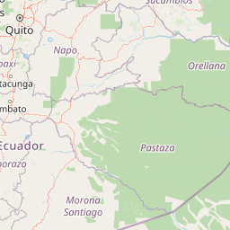
Map view of Cotopaxi National Park

Use this park location map to pinpoint Cotopaxi National Park in Ecuador, understand its exact geographic position, and read its mapped placement within the surrounding landscape more clearly.

Pigeon | © OpenStreetMap contributors

Location context for Cotopaxi National Park

Cotopaxi ProvinceNapo ProvincePichincha Province
Natural feature types

Examine the Natural Feature Geography of Cotopaxi National Park

Trace the diverse landforms, volcanic summits, and glacial systems that define this protected highland region. Use this MoriAtlas index to understand the distribution of natural features within the park and how they connect to the broader Andean landscape.
Recorded earthquake history

Examine Historical Earthquake Records for Cotopaxi National Park

Investigate the documented history of seismic events identified within the vicinity of Cotopaxi National Park. MoriAtlas provides this organized data to assist in the geographic understanding of regional activity, offering consistent tracking of epicentre distances and historical magnitude reports for the park.

Cotopaxi National Park Earthquake History

Catalogued events

79 events

Strongest magnitude

Magnitude 6.4

Most recent event

Dec 19, 2025

This history includes earthquakes recorded inside the park or within 50 km of its borders

Park atlas

Trace the regional spread of protected areas, comparing diverse volcanic landscapes and high-altitude páramo ecosystems across the Ecuadorian Andes.

Explore National Parks and Protected Areas Near Cotopaxi National Park, Ecuador's Volcanic Andean Highlands

Continue your exploration from Cotopaxi National Park to browse a curated list of other national parks and protected areas across Ecuador's central highlands. Compare diverse volcanic landscapes, high-altitude páramo ecosystems, and mountain environments to understand their regional distribution and conservation significance within the Andean chain.
Nature reserveEcuador
8.4 km away#1 closest

West

Reserva Ecológica Los Illinizas: Geographic Atlas and Andean Protected Nature Reserve

Volcanic terrain and cloud forest ecosystems in central Ecuador

Spanning across the provinces of Cotopaxi, Pichincha, and Santo Domingo de los Tsáchilas, Reserva Ecológica Los Illinizas preserves a significant vertical gradient of Andean ecosystems. The reserve protects the western flanks of the Illiniza volcanoes, Quilotoa, and El Corazón, offering a detailed look at high-altitude biodiversity and the transition from rugged mountain peaks to lush western cloud forests.

Area
1,342.33 km²
Established
1996
IUCN
Ia
Relief
Mountain
National parkEcuador
12 km away#2 closest

Southeast

Llanganates National Park: Detailed Atlas Entry for Ecuador's Protected Landscape

Explore the mapped geography and regional context of this Ecuadorian national park.

Llanganates National Park is a designated national park offering rich opportunities for geographic and landscape exploration. As a significant protected area in Ecuador, it provides crucial context for understanding the country's natural terrain and the distribution of its conservation landscapes. This entry is designed to facilitate an atlas-style discovery of the park's location, boundaries, and its role within the broader geography of the region.

Area
2,197.07 km²
Established
1996
IUCN
II
Relief
Mountain
Wildlife reservePichincha
About 12 km away#3 closest

North

Refugio de Vida Silvestre Pasochoa: Volcanic Crater and Andean Forest Protected Area

Geographic atlas of the Pichincha volcanic highlands

Located in the Pichincha province, Refugio de Vida Silvestre Pasochoa protects an essential highland habitat defined by its steep volcanic crater walls and dense bamboo stands. This area provides a scientific reference for inter-Andean vegetation, featuring a sharp contrast between forested inner slopes and surrounding agricultural landscapes. Map the ecological gradient of this protected refuge and explore its role within the broader northern Andean geographic context.

Area
9.799 km²
Established
1996
IUCN
Ib
Relief
Mountain
National parkNapo
17 km away#4 closest

East

Parque nacional Antisana: Volcanic Terrain and Andean Protected Area Geography

High-altitude ecosystems spanning Napo and the Andean corridor

Spanning the rugged Cordillera Real, Parque nacional Antisana protects a vast sweep of volcanic terrain dominated by its central stratovolcano. From glacial fields to the water-retention capacity of its páramo wetlands, the area represents a crucial node in Ecuador's conservation network, providing a sanctuary for Andean condors and diverse montane species.

Area
1,205.81 km²
Established
1993
IUCN
Ia
Relief
Mountain
Biosphere reserveNapo
About 26 km away#5 closest

East

Reserva Biológica Colonso-Chalupas: Protected Landscapes of the Upper Napo Basin

A critical vertical corridor of the Ecuadorian Andes and Amazon.

Reserva Biológica Colonso-Chalupas represents a unique bioclimatic transition, stretching nearly 4,000 meters in elevation. This biosphere reserve serves as a functional corridor connecting high-altitude páramo and cloud forests to warm, humid Amazonian lowlands, forming a key structural element of the eastern Andean conservation landscape.

Area
931.63 km²
Established
2014
Relief
Mountain
Climate
Alpine
National parkEcuador
62 km away#6 closest

East

Sumaco Napo-Galeras National Park: Ecuador's Volcanic National Park Landscape

Explore protected areas and biodiversity in the Andean-Amazon transition.

Sumaco Napo-Galeras National Park protects a dramatic volcanic landscape in Ecuador, showcasing a significant elevation gradient that supports diverse cloud forest and Amazonian rainforest habitats. This national park is recognized for its endemic species and rich avifauna, offering a compelling case study for understanding protected land geography and ecological transitions within South America.

Area
2,067.49 km²
Established
1994
IUCN
II
Relief
Mountain
Nature reservePichincha
About 67 km away#7 closest

North

Reserva Geobotánica Pululahua: Protected Volcanic Caldera and Highland Ecosystems

A distinct geobotanical reserve in the Pichincha region of the Ecuadorian Andes.

Reserva Geobotánica Pululahua is a protected natural area centered on a massive, 12-kilometer-wide volcanic caldera. Its landscape features three prominent lava domes and a rare altitudinal gradient of vegetation, spanning from semi-dry mountain shrubland to dense cloud forest. This reserve serves as a critical study of volcanic geology and human-landscape interaction in the high Andes, offering a concentrated look at Ecuador's vertical ecological zonation.

Area
34.417 km²
Established
1966
Relief
Mountain
Climate
Subtropical
Wildlife reserveChimborazo
69 km away#8 closest

Southwest

Reserva de Producción de Fauna Chimborazo: Volcanic Landscapes and Andean Wildlife Reserve

High-altitude watershed and páramo geography in central Ecuador.

Spanning from glacial summits to arid puna plains, the Reserva de Producción de Fauna Chimborazo represents a complex Andean ecosystem. This wildlife reserve protects vital watersheds, glacial meltwater sources, and native camelid habitats within the shadows of Ecuador's tallest peaks, offering a detailed look at high-altitude conservation and volcanic terrain.

Area
526.83 km²
Established
1987
IUCN
IV
Relief
Mountain

Common questions about visiting, size, designation, and location context for Cotopaxi National Park

Cotopaxi National Park FAQs for park facts, access, geography, and protected area context

Find quick answers about Cotopaxi National Park, including protected-area facts, park geography, trail and visitor context, and how the park fits into its surrounding country and regional landscape.
MoriAtlas Explorer

Continue Your Protected Areas Search Across the Global Atlas

Deepen your exploration by continuing the structured search for national parks and protected areas worldwide. Utilize the comprehensive filtering capabilities to compare different conservation landscapes and refine your understanding of global park geography. Discover more about the distribution and characteristics of protected natural areas.

Global natural geography