

Mori Atlas logo
Nature reserveDiable Skały

A detailed geographic atlas of rock formations, tectonic caves, and forest terrain in Lesser Poland

Diable Skały Nature Reserve: Exploring the Sandstone Landscapes of the Carpathian Foothills

(Rezerwat przyrody Diable Skały)

Diable Skały Nature Reserve represents a protected enclave of geological importance within the Pogórze Rożnowskie foothills of southern Poland. This site is defined by its dramatic Ciężkowice sandstone formations, including towers, walls, and mushroom-shaped rocks scattered across the forested slopes of Bukowiec hill. Beyond the surface geology, the reserve encompasses the tectonic crevice cave system known as Diabla Dziura, providing essential habitat for regional bat colonies and contributing to the protected ecological character of the Lesser Poland Voivodeship.

sandstone formationsrock labyrinthCarpathian foothillscrevice cavebat hibernationNatura 2000
A colorful illustration showing a tall sandstone rock formation amidst a forest, with a smaller moss-covered boulder in the foreground and tall tree trunks framing the scene.

Diable Skały

Nature reserve

Park overview

Structured park overview, official facts, and landscape profile for Diable Skały Nature Reserve

Diable Skały Nature Reserve park facts, protected area profile, and essential visitor context

Review the core facts for Diable Skały Nature Reserve, including designation, size, terrain, visitor scale, habitats, and operating context in one park-focused overview.

About Diable Skały Nature Reserve

Diable Skały is a compact geological nature reserve that captures one of the more photogenic sandstone landscapes in the Pogórze Rożnowskie foothills of southern Poland. Located near the village of Bukowiec, just west of the Dunajec river basin in the Małopolskie voivodeship, the reserve occupies the summit zone of the Bukowiec hill at about 530 meters and continues westward along the ridge that descends from it. Despite covering only a small area, it concentrates a striking density of rock forms and shelters some of the more unusual wildlife features of the region.

The character of Diable Skały is defined by its rocks. The Ciężkowice sandstones, originally deposited on the floor of the ancient Tethys Ocean roughly 58 to 48 million years ago, were later lifted into the Carpathians as part of the Silesian nappe. After the retreat of Pleistocene glaciers, when vegetation had not yet fully reclaimed the slopes, the sandstones were exposed to selective weathering, erosion, solifluction, and shallow mass movements. Over time these processes sculpted the parent rock into a collection of isolated towers, pulpit-like outcrops, mushroom-shaped blocks, stone walls, tables, and ledges, some reaching heights of about ten meters. Fallen smaller blocks lie scattered on the forest floor below the main outcrops, adding to the geological character of the area.

Within this rocky framework sits Diabla Dziura w Bukowcu, a tectonic crevice cave of notable size for the region, surrounded by several smaller caves and rock shelters such as Jama pod Lucyferem, Jaskinia pod Okapem, Kapi Okap, and Schronisko Diabli Most. The reserve is forest-covered and threaded by an educational trail with nine marked stops, including viewpoints and individually named rocks such as Diabeł, Samotna Skała, Grzyb, and Kapa. The combination of geological, ecological, and educational value makes Diable Skały a popular local destination, easily reached from nearby churches and from a network of long-distance hiking trails that pass along its edges.

Quick facts and research context for Diable Skały Nature Reserve

Diable Skały is a geological and soil nature reserve of tectonic and erosive landforms, located near Bukowiec in the Korzenna commune of Nowy Sącz County, Małopolskie voivodeship. It was established in 1953 by order of the Minister of Forestry to protect Ciężkowice sandstone rock groups and the large crevice cave Diabla Dziura w Bukowcu. The reserve lies within the Pogórze Rożnowskie mesoregion and overlaps the Natura 2000 habitat area "Ostoje Nietoperzy okolic Bukowca" (PLH120020).

Protection and recognition

Terrestrial protected area classification and management scope

Diable Skały Protection Status and Conservation Framework Details

Diable Skały maintains a documented terrestrial protection status within its regional conservation landscape. Official records outline the established management scope and international recognition data for this protected area.

Protection details

Protection scope
Terrestrial
Transboundary protection
No
Park context

Deeper park guide and search-rich context for Diable Skały Nature Reserve

Diable Skały Nature Reserve history, landscape, wildlife, and travel context

Explore Diable Skały Nature Reserve through its history, landscape character, ecosystems, wildlife, conservation priorities, cultural context, and seasonal travel timing in a structured park guide built for atlas discovery and search intent.

Why Diable Skały Nature Reserve stands out

Diable Skały is best known for its dramatic Ciężkowice sandstone rock formations, which appear throughout the forested summit area of the Bukowiec hill in the form of towers, walls, mushroom rocks, and isolated blocks. Equally distinctive is the tectonic crevice cave Diabla Dziura w Bukowcu, a rare feature of substantial size within the Carpathian foothills. The reserve is also recognized for its bat populations, with the cave serving as a wintering site for the lesser horseshoe bat and the greater mouse-eared bat.
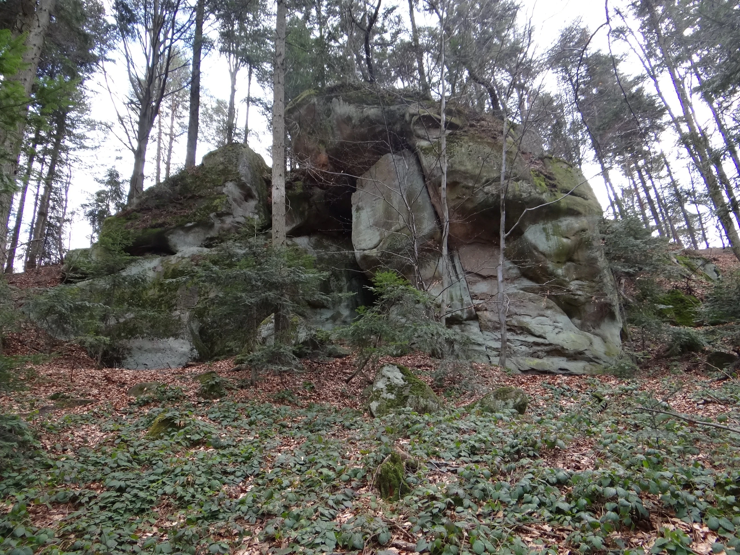
A large, weathered sandstone rock formation sits surrounded by tall, slender forest trees on a hill covered with dead leaves and low ground vegetation.
Large sandstone rock formations located within the Diable Skały nature reserve.

Diable Skały Nature Reserve history and protected-area timeline

The rocks of Diable Skały have long attracted local curiosity. Because the sandstone blocks scattered through the forest are far too large to have been moved by human hands, a legend emerged among local communities that the devil himself had carried the stones in his claws all the way from Hungary. The formations were already being visited as a curiosity before the Second World War, and a hiking trail was marked through the area in that earlier period.

Shortly after the war, in 1953, the Minister of Forestry issued the official order establishing Diable Skały as a nature reserve. The protection was intended to safeguard both the sandstone rock groups and the sizable tectonic crevice cave Diabla Dziura w Bukowcu, recognizing the site's geological significance for the outer Carpathians. The cave was later gated, and its access has since required permission from the regional environmental protection authority. In more recent decades the reserve's ecological profile was further strengthened when it was included within the Natura 2000 habitat site "Ostoje Nietoperzy okolic Bukowca," acknowledging the importance of the cave as a bat roost.

Diable Skały Nature Reserve landscape and geographic character

Diable Skały sits within the Pogórze Rożnowskie, a foothill mesoregion of the Western Carpathians characterized by rolling ridges, forested slopes, and clear sandstone exposures. The reserve occupies the highest ground of the Bukowiec hill and the ridge that falls away from it toward the west, so that visitors encounter rocks both at the summit and along the descending spine of the hill.

The most striking element of the scenery is the collection of Ciężkowice sandstone forms. Thick-bedded, coarse-grained, and originally deposited under marine conditions, these sandstones have been shaped by post-glacial weathering into a small "rock city" of isolated towers, pulpit-shaped outcrops, walls, plateau-like tables, ledges, and mushroom-shaped stones. Heights reach up to about ten meters in the larger towers, with smaller loose blocks resting in the forest beneath. The combination of upright monuments and tumbled fragments gives the landscape the feel of a natural labyrinth, with narrow passages winding between rock walls.

The terrain is gentle rather than alpine; this is foothills country, not high mountains. The slopes are densely wooded, the rock formations emerge abruptly from the forest, and viewpoints along the educational trail reveal broader vistas over the surrounding Pogórze Rożnowskie hills. The forest context, the scale of the rocks, and the scattered arrangement of the outcrops together define the visual identity of the reserve.
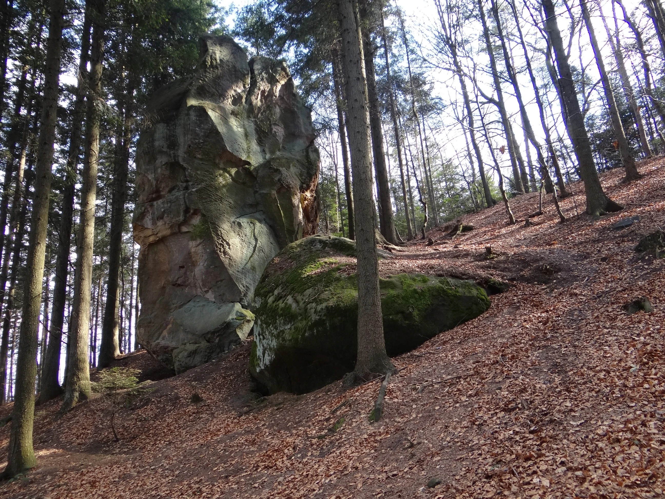
A large, weathered sandstone rock formation towers over a forest floor covered in autumn leaves.
A prominent sandstone rock formation within the Diable Skały nature reserve.

Diable Skały Nature Reserve ecosystems, habitats, and plant life

Ecologically, Diable Skały is primarily a forest reserve set within the Carpathian foothills. Its vegetation is typical of mixed foothill woodland of the region, with coniferous and broadleaf stands cloaking the slopes of the Bukowiec hill and surrounding the rock outcrops. The forest acts as a frame for the sandstone monuments, but it also plays a functional role: the shaded, humid microclimate around the rocks and crevices supports distinctive habitats for mosses, lichens, and invertebrates, while the more open, sun-warmed rock faces host their own specialized flora.

The most ecologically distinctive feature, however, lies beneath the surface. The tectonic crevice cave Diabla Dziura w Bukowcu, supplemented by a cluster of smaller caves and rock shelters such as Jama pod Lucyferem, Jaskinia pod Okapem, Kapi Okap, and Schronisko Diabli Most, creates a network of underground habitats that is rare at this elevation in the outer Carpathians. These cavities maintain the cool, stable, and humid conditions required by cave-dwelling species. The surrounding forest extends this habitat mosaic, providing foraging grounds and ecological connectivity for species that depend on both the woodland canopy and the underground shelters.
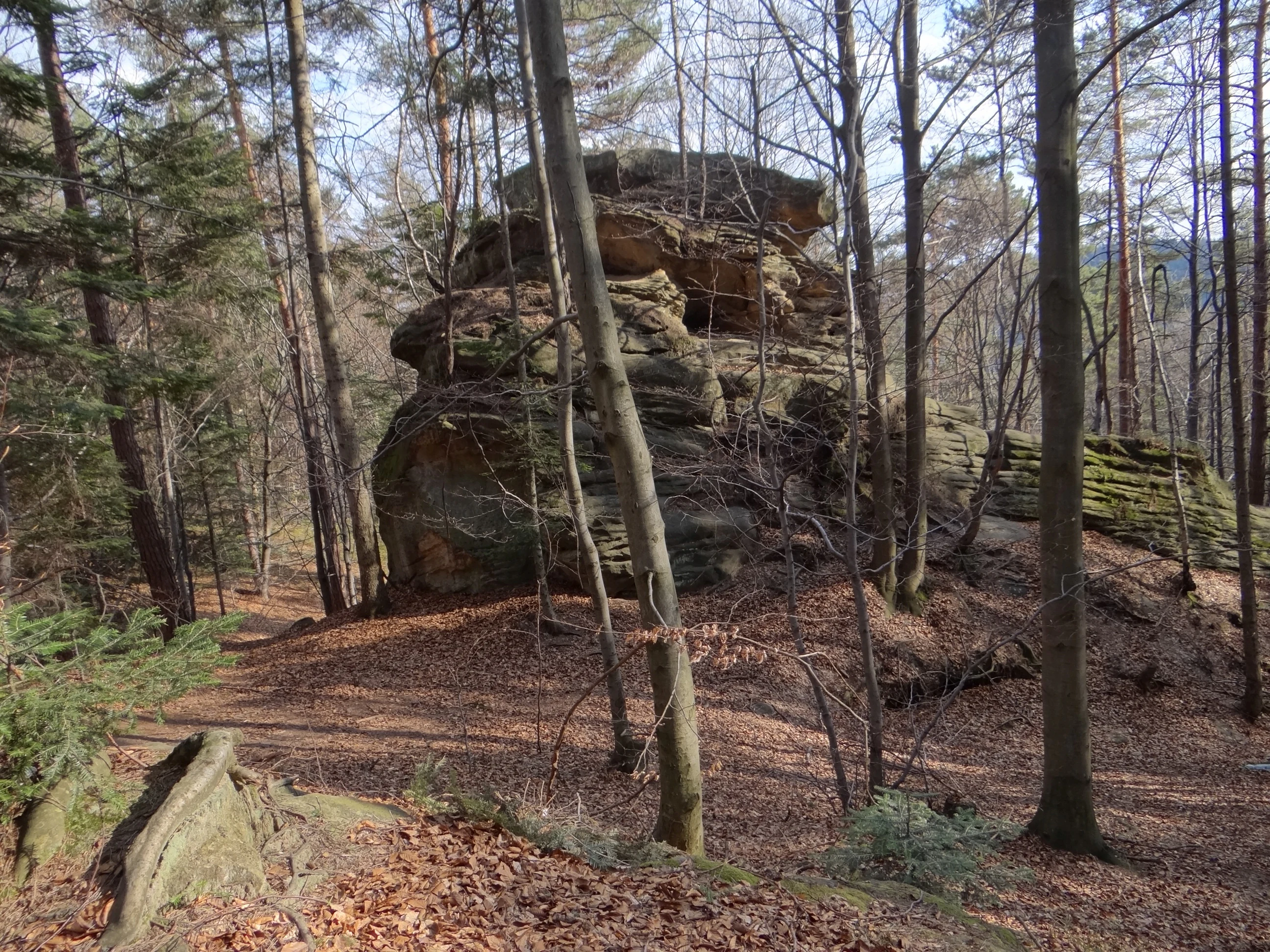
A weathered mushroom shaped sandstone rock formation standing in a forest with dry leaves on the ground.
A distinctive mushroom shaped sandstone rock formation within the forest of Diable Skały nature reserve.

Diable Skały Nature Reserve wildlife and species highlights

Wildlife information for Diable Skały centers, appropriately, on its bats. The cave Diabla Dziura w Bukowcu is a documented winter roost for the lesser horseshoe bat and the greater mouse-eared bat, two species that depend heavily on stable underground shelters for hibernation. The presence of these bats is one of the key reasons the area was incorporated into the Natura 2000 habitat site "Ostoje Nietoperzy okolic Bukowca" (PLH120020).

The forested character of the reserve also supports a typical range of Carpathian foothill fauna typical of mixed woodland in the region, while the rock walls and crevices provide nesting and shelter opportunities for bird and small mammal species adapted to cliff and cave environments. Although the broader reserves of the Pogórze Rożnowskie foothills host additional species of conservation interest, the protection profile of Diable Skały is concentrated on the bat hibernacula and the surrounding forest mosaic.

Diable Skały Nature Reserve conservation status and protection priorities

Conservation value at Diable Skały centers on three connected strands: geological heritage, cave habitat, and forest cover. As one of the older Polish nature reserves, established in 1953, it was an early recognition that even small foothill sites can contain unusual landforms worthy of formal protection. The reserve safeguards a representative cluster of Ciężkowice sandstone formations that would otherwise remain vulnerable to weathering, erosion, and human disturbance.

The cave system adds a second, more specialized layer of conservation importance. Diabla Dziura w Bukowcu and its associated shelters host hibernating bat populations and maintain the microclimate conditions essential for cave-dependent species. Inclusion of the reserve in the Natura 2000 habitat area "Ostoje Nietoperzy okolic Bukowca" formally recognizes the site as part of the European network protecting threatened habitats and species.

A third element is the surrounding forest matrix, which buffers the rocks and caves, supports wildlife movement across the ridge, and maintains the visual integrity of the landscape. The cave is gated, and access requires permission from the regional environmental protection authority, restricting disturbance to the most sensitive underground sections. The educational trail through the reserve, with nine numbered stops and informational boards, balances public access with the need to keep visitors on designated paths.

Diable Skały Nature Reserve cultural meaning and human context

The cultural dimension of Diable Skały is rooted in local folk imagination rather than in built heritage. Because the heavy sandstone blocks scattered through the forest could not have been moved by people, a regional legend arose that the devil carried them in his claws from Hungary. The very name "Diable Skały," meaning "Devil's Rocks," preserves this story, tying the geological character of the site to a long-standing oral tradition.

Nearby cultural landmarks complement a visit to the reserve: the educational trail begins beside a road leading to a historic wooden church dedicated to the Immaculate Heart of the Blessed Virgin Mary, which itself incorporates a former Orthodox church relocated from the village of Kamianna. While these structures lie just outside the protected area, they help situate the reserve within a broader rural and religious heritage landscape of the Małopolskie foothills.

Top sights and standout views in Diable Skały Nature Reserve

The Diabeł, the tower-like sandstone outcrop that lends the reserve its name, and the mushroom-shaped Grzyb rock are among the most photographed features. The viewpoint stop along the educational trail offers a wider view over the Pogórze Rożnowskie foothills, while the gated Diabla Dziura cave highlights the tectonic and biological depth of the site. The combination of named rock formations, accessible viewpoints, and a short, well-marked trail make the reserve approachable for visitors interested in geology as well as casual hikers.

Best time to visit Diable Skały Nature Reserve

Diable Skały can be visited year-round, as the rocks and forest are not subject to strong seasonal access restrictions. Late spring and early summer are particularly rewarding, when mild weather, fresh foliage, and active bat movements outside the cave make the trail lively and the rocks are framed by greenery. Early autumn brings colorful foliage over the foothill slopes and comfortable temperatures for walking the ridge. Winter visits offer a quieter atmosphere and clearer views through the bare deciduous trees, although visitors should expect potentially icy conditions on the rocks and forest paths.

Monthly climate preview

Long-term temperature and precipitation cycles recorded at the representative coordinate

Diable Skały Climate Normals and Monthly Weather Patterns

Diable Skały exhibits a measured annual temperature range spanning subzero winter lows to warm summer maximums alongside consistent monthly precipitation. Reviewing the complete twelve-month climate profile reveals precise long-term averages for every seasonal transition across the reserve.
Annual mean8 °C
-3 °C20 °C
Jan-3°
Feb-2°
Mar
Apr
May14°
Jun18°
Jul20°
Aug20°
Sep14°
Oct
Nov
Dec-2°
Warmest month
July

19.8 °C

Coolest month
January

-3.3 °C

Wettest month
July

3.4 mm/day

Driest month
December

1.3 mm/day

Park location guide

Geography guide, regional context, and park location map for Diable Skały Nature Reserve

Diable Skały Nature Reserve park geography, regions, and map view in Poland

Understand where Diable Skały Nature Reserve sits in Poland through a broader geographic reading of the surrounding landscape, nearby location context, and its mapped position within the national park landscape.

How Diable Skały Nature Reserve fits into Poland

Poland, officially the Republic of Poland, is a Central European country spanning from the Baltic Sea in the north to the Carpathian Mountains in the south. It borders Germany, Czech Republic, Slovakia, Ukraine, Belarus, Lithuania, and Kaliningrad Oblast. The country has a temperate climate, diverse landscapes, and is known for its rich history, cultural heritage, and strong economic position within the EU.

Wider geography shaping Diable Skały Nature Reserve in Poland

Poland occupies 312,696 km2 in Central Europe, extending from the Baltic Sea coast in the north to the Sudetes and Carpathian Mountains in the south. It borders Germany to the west, Czech Republic and Slovakia to the south, Ukraine and Belarus to the east, and Lithuania and Kaliningrad Oblast to the northeast. The landscape includes lowland plains, uplands, and mountain ranges.

Map view of Diable Skały Nature Reserve

Use this park location map to pinpoint Diable Skały Nature Reserve in Poland, understand its exact geographic position, and read its mapped placement within the surrounding landscape more clearly.

Pigeon | © OpenStreetMap contributors

Location context for Diable Skały Nature Reserve

Lesser Poland Voivodeship

Visualizing the sandstone rock labyrinths, forest canopies, and protected terrain of southern Poland

Diable Skały Photos and Landscapes: Exploring the Sandstone Formations of Carpathian Foothills

Visual records reveal the dramatic Ciężkowice sandstone towers, weathered rock tables, and forest habitats that define the protected landscape. Examining these field photographs helps researchers and visitors understand the geological terrain and biological shelter found across the reserve.

A large, weathered sandstone rock formation sits surrounded by tall, slender forest trees on a hill covered with dead leaves and low ground vegetation.

A large, weathered sandstone rock formation with a protruding ledge, situated in a forest with leaf-covered ground.

A large, weathered sandstone rock formation towers over a forest floor covered in autumn leaves.

A weathered mushroom shaped sandstone rock formation standing in a forest with dry leaves on the ground.

Park atlas

Compare nearby Carpathian foothill reserves and connected protected areas

Explore Parks Near Diable Skały and Surrounding Protected Landscapes

Browse other parks near Diable Skały to uncover related geological formations and forested ridge terrain across the region. Extending the geographic comparison reveals broader protected landscapes and similar foothill environments throughout southern Poland.
Protected areaLesser Poland Voivodeship
Mapped location lies within the park boundary#1 closest

Northeast

Ostoje Nietoperzy okolic Bukowca: Geography and Protected Area Overview

A forest and cave sanctuary in the Lesser Poland Voivodeship.

This protected area represents an ecologically coherent network of forest habitats and hibernation sites across the Pogórze Rożnowskie. It preserves Carpathian woodland remnants and essential roosting environments, offering a detailed look at micro-scale landscape conservation and geological formations like Diabla Dziura in the Polish countryside.

Area
5.863 km²
Established
2008
Relief
Upland
Climate
Temperate
A watercolor painting of a panoramic landscape featuring green forests, a rocky outcrop on the right, and soft rolling hills in the background against a white background.
Protected landscapeLesser Poland Voivodeship
About 6.3 km away#2 closest

Northeast

Ciężkowicko-Rożnowski Park Krajobrazowy: Geological Features and Protected Foothill Terrain

An Essential Protected Landscape in Lesser Poland Voivodeship

Ciężkowicko-Rożnowski Park Krajobrazowy spans the rolling hills of the Pogórze Rożnowskie and Pogórze Ciężkowickie. This protected area showcases a complex geography of sandstone crags, xerothermic grasslands, and old-growth forest remnants. Its map highlights a dense network of geological monuments, mineral water springs, and deep stream valleys that define this distinctive Małopolska landscape.

Area
182.472 km²
Established
1995
Relief
Upland
Climate
Temperate
A soft watercolor illustration depicting a winding stream flowing through a green mountain valley with forested slopes in the background.
Protected areaLesser Poland Voivodeship
About 14 km away#3 closest

West

Łososina Protected Area: Mapped Landscapes and Riparian Geography in Southern Poland

A concentrated Natura 2000 conservation site in the Pogórze Rożnowskie foothills

The Łososina protected area features a unique sequence of stream-side habitats including grey willow scrub and mature alder floodplain forests. Mapped across four distinct enclaves in the Lesser Poland Voivodeship, the terrain provides essential shelter for the Mediterranean barbel, reflecting a highly intact submontane ecosystem maintained by active mountain stream processes.

Area
3.454 km²
Relief
Upland
Water
Major water bodies
Protected areaLesser Poland Voivodeship
About 15 km away#4 closest

Southwest

Środkowy Dunajec z dopływami: Protected River Habitats and Carpathian Foothills Geography

Exploring the river corridor and riparian ecosystems of southern Poland

Spanning 755 hectares across four connected enclaves, Środkowy Dunajec z dopływami protects the vital riverine systems of the middle Dunajec and its tributaries. This site offers a unique look at the fluvial processes and biodiversity of Carpathian mountain streams, showcasing diverse habitat structures from pioneer gravel banks to mature riparian forests.

Area
7.56 km²
Relief
Upland
Scope
Terrestrial
Water
Major water bodies
Nature reserveLesser Poland Voivodeship
About 15 km away#5 closest

Northeast

Ostoja w Paśmie Brzanki: Protected Beech Forest and Foothill Geography in Lesser Poland

A Natura 2000 nature reserve in the Polish Carpathian foothills

Located within the Lesser Poland Voivodeship, Ostoja w Paśmie Brzanki consists of dense, continuous beech woodlands draped over the rounded ridges of the Brzanka Range. This nature reserve serves as an essential ecological refuge, combining rare sycamore communities and riparian strips that support diverse amphibian populations across its forested ravine landscapes.

Area
7.889 km²
Established
2011
Relief
Upland
Water
Minor water
Protected areaLesser Poland Voivodeship
About 20 km away#6 closest

South

Łabowa Protected Area: Forested Carpathian Foothills and Riparian Habitats in Lesser Poland

A key Natura 2000 site protecting mountain stream ecosystems and forest diversity

Located in the Lesser Poland Voivodeship, Łabowa is a significant protected area known for its continuous forest cover and diverse stream-influenced terrain. Spanning over 3,000 hectares, this site offers deep insight into the ecological character of the Carpathian foothills and the preservation of habitat for sensitive bat species.

Area
33.04 km²
Relief
Mountain
Water
Major water bodies
Protected areaPodkarpackie Voivodeship
About 22 km away#7 closest

East

Wisłoka z dopływami Protected Area: River Valley Landscape and Carpathian Foothills Atlas

Freshwater habitat mapping in southern Poland

Wisłoka z dopływami covers a long, ecologically rich segment of the Wisłoka river valley in the Carpathian foothills. This protected area connects diverse riparian, floodplain, and alluvial forests, serving as a critical habitat for six Annex II fish species and sixteen distinct riparian woodland types.

Area
26.51 km²
Established
2011
Relief
Mixed relief
Scope
Terrestrial
Protected areaLesser Poland Voivodeship
About 22 km away#8 closest

Southeast

Ostoje Nietoperzy Powiatu Gorlickiego: Landscape and Protected Area Geography

A twelve-enclave forest network in the Lesser Poland foothills

Spanning roughly 2,825 hectares across Gorlice County, this protected area preserves representative stands of Central European beech and mixed slope forests. Through its unique multi-enclave design, the site acts as a key refuge for saproxylic beetles, Carpathian newts, and specialized chiropteran species that rely on the mosaic of mature timber and subterranean shelters in the Polish landscape.

Area
28.249 km²
Scope
Terrestrial
Forest
Mostly forested

Common questions about visiting, size, designation, and location context for Diable Skały Nature Reserve

Diable Skały Nature Reserve FAQs for park facts, access, geography, and protected area context

Find quick answers about Diable Skały Nature Reserve, including protected-area facts, park geography, trail and visitor context, and how the park fits into its surrounding country and regional landscape.
MoriAtlas Explorer

Continue Your Protected Areas Search Across the Global Atlas

Deepen your exploration by continuing the structured search for national parks and protected areas worldwide. Utilize the comprehensive filtering capabilities to compare different conservation landscapes and refine your understanding of global park geography. Discover more about the distribution and characteristics of protected natural areas.

Global natural geography