Mori Atlas logo
National parkDjebel Aissa National Park

Trace the mapped boundaries of this national park within Algeria's diverse terrain.

Djebel Aissa National Park: Algeria's Protected Landscape and Geographic Identity

Djebel Aissa National Park stands as a significant protected area within Algeria, offering a distinct national park landscape for geographic exploration. This entry provides essential context for understanding the park's protected boundaries, its relationship to the surrounding terrain, and its place within the atlas of North African natural landscapes. Delve into the specific geography that defines this Algerian national park and its unique ecological context.

National ParkSaharan AtlasJuniper ForestMountain EcosystemsAlgeriaWestern Highlands

Djebel Aissa National Park

National park

Park overview

Structured park overview, official facts, and landscape profile for Djebel Aissa National Park

Djebel Aissa National Park park facts, protected area profile, and essential visitor context

Review the core facts for Djebel Aissa National Park, including designation, size, terrain, visitor scale, habitats, and operating context in one park-focused overview.

About Djebel Aissa National Park

Djebel Aissa National Park occupies a significant position in Algeria's protected area network as a conservation stronghold for the Saharan Atlas mountain ecosystem. The park's location in the Western Highlands places it at a critical ecological crossroads, where Mediterranean-influenced forest ecosystems meet the expanding Sahara Desert. This transition zone supports a distinctive assemblage of plant species that have adapted to seasonal drought, extreme temperature variations, and limited precipitation. The park was created specifically to address growing concerns about ecosystem degradation in the region, where overgrazing, wood collection, and climate change have contributed to forest loss and habitat fragmentation. Protecting the remaining forest stands and the wildlife they support has become increasingly urgent as desertification advances across the Hauts Plateaux.

Quick facts and research context for Djebel Aissa National Park

Djebel Aissa National Park lies in western Algeria within the Saharan Atlas mountains, near the town of Ain Sefra. The park covers 24,400 hectares and was established in 2003 under the administration of the Ministry of Spatial Planning and Environment. It is classified as an IUCN Category II protected area. The ecosystem represents a unique transition zone between Saharan and Mediterranean environments, supporting forest habitats that are increasingly rare in this part of Algeria.

Protection and recognition

Tracking the official terrestrial conservation status and documented landscape boundaries

Djebel Aissa National Park Protection Status and Terrestrial Conservation Scope

Official conservation records define Djebel Aissa National Park as a dedicated terrestrial protected area within the regional geographic framework. Accessing documented designation files allows researchers to verify international registry standing and analyze terrestrial conservation networks across the region.

Protection details

Protection scope
Terrestrial
Transboundary protection
No
Park context

Deeper park guide and search-rich context for Djebel Aissa National Park

Djebel Aissa National Park history, landscape, wildlife, and travel context

Explore Djebel Aissa National Park through its history, landscape character, ecosystems, wildlife, conservation priorities, cultural context, and seasonal travel timing in a structured park guide built for atlas discovery and search intent.

Why Djebel Aissa National Park stands out

Djebel Aissa National Park is particularly known for its juniper and pine forest ecosystems that survive in the Saharan Atlas, representing the westernmost extension of Mediterranean forest types into the Sahara's edge. The park protects critical habitat for the Barbary sheep, a distinctive North African mountain ungulate, as well as populations of Dorcas gazelle, bustards, and other Saharan-adapted wildlife. Its conservation significance stems from protecting forest stands of Juniperus phoenicea, Quercus ilex, and Pinus halepensis in an environment where desertification pressures threaten to eliminate these habitats.

Djebel Aissa National Park history and protected-area timeline

Djebel Aissa National Park was established in 2003 through official governmental decree, marking a formal commitment to conserving the Saharan Atlas ecosystems of western Algeria. The park's creation reflected growing recognition among Algerian environmental authorities that the Western Highlands region required dedicated protection to prevent further ecosystem collapse. Prior to formal protection status, the area had experienced gradual environmental degradation from human activities and climate pressures. The establishment of the park placed it under the management of the Ministry of Spatial Planning and Environment, aligning it with Algeria's broader national park system. The designation also aimed to provide a framework for sustainable management that could balance conservation objectives with the needs of local communities who depend on the landscape.

Djebel Aissa National Park landscape and geographic character

The terrain of Djebel Aissa National Park consists of mountainous and plateau landscapes characteristic of the Saharan Atlas range. The topography features rugged mountain slopes, elevated plateaus, and intervening valleys that channel seasonal precipitation and support vegetation growth. The elevation range creates microclimatic conditions that allow forest species to persist in an otherwise arid regional context. The landscape includes exposed rocky outcrops, forest-covered slopes, and open steppe areas that transition between the forested highlands and the desert lowlands. This varied topography contributes to the park's ecological diversity by creating multiple habitat zones within a relatively compact area.

Djebel Aissa National Park ecosystems, habitats, and plant life

The ecological character of Djebel Aissa National Park reflects its position at the boundary between Mediterranean and Saharan biomes. The park supports forest communities dominated by juniper species, including Juniperus phoenicea and Juniperus oxycedrus, alongside Aleppo pine and evergreen oak. These forest formations represent relict species assemblages that have survived in favorable microhabitats within the Saharan Atlas. The understory and surrounding areas support steppe vegetation including Esparto grass and Artemisia alba, which provide additional habitat structure and ecological function. The combination of forest and steppe creates a complex habitat matrix that supports diverse species assemblages.

Djebel Aissa National Park wildlife and species highlights

The mammalian fauna of Djebel Aissa National Park includes several species adapted to the mountainous Saharan environment. The Barbary sheep represents one of the park's most notable large mammals, a species well-suited to rocky terrain and arid conditions. Dorcas gazelle populations persist in the park's more open terrain, while smaller mammals include hares, porcupines, and various carnivores such as foxes and jackals. Wild boar inhabit the forest areas where ground cover and seasonal food sources are available. The bird fauna includes bustards, which are characteristic ground-nesting birds of open steppe and grassland habitats throughout the Saharan Atlas region.

Djebel Aissa National Park conservation status and protection priorities

Djebel Aissa National Park serves as a critical refuge for forest ecosystems in a region facing severe desertification pressures. The park protects genetic reservoirs of Mediterranean tree species at their southern and eastern range limits, where climate stress and human activity have reduced forest cover across the Hauts Plateaux. Conservation of this area addresses multiple environmental challenges including soil stabilization, watershed protection, and maintenance of biodiversity corridors. The park's designation provides a framework for managed use that can reduce extractive pressures while allowing sustainable engagement with the landscape. Protecting the Barbary sheep and Dorcas gazelle populations is particularly important for maintaining viable breeding populations of these species in Algeria.

Djebel Aissa National Park cultural meaning and human context

The park exists within a cultural landscape where traditional pastoral activities have shaped the relationship between local communities and the mountain environment. The region's Berber heritage includes long-established patterns of transhumance and seasonal resource use that interact with the park's ecosystems. While the park's primary focus is on ecological conservation, its management must account for the historical presence of pastoral communities whose activities influence landscape character. The Arabic designation of the park reflects its integration into the broader regional identity of the Naâma wilaya.

Top sights and standout views in Djebel Aissa National Park

Djebel Aissa National Park protects some of the most significant remaining juniper and pine forests in the Saharan Atlas, offering a glimpse of the Mediterranean forest ecosystems that once covered broader areas of this mountain range. The park provides habitat for Barbary sheep and Dorcas gazelle, two iconic North African ungulates whose conservation depends on protected area networks. Its position on the edge of the Sahara makes it a valuable location for understanding ecosystem transitions and climate change impacts on mountain environments. The combination of forest, steppe, and mountain habitats creates ecological diversity uncommon in Saharan-protected areas.

Best time to visit Djebel Aissa National Park

The optimal period for visiting Djebel Aissa National Park spans from spring through early autumn, when temperatures in the highlands are moderate and vegetation provides ecological interest. Spring brings blooming vegetation and active wildlife activity, while summer months offer warm conditions suitable for exploring the park's trails. The shoulder seasons of spring and autumn generally provide the most comfortable conditions for outdoor activities, though visitors should be prepared for temperature variations between day and night. The park's mountain setting means that weather conditions can change rapidly, and visitors should check current conditions before planning activities.

Monthly climate preview

Long-term monthly temperature and precipitation data for Djebel Aissa National Park

Djebel Aissa National Park Climate Normals and Annual Temperature Patterns

Djebel Aissa National Park exhibits a measured annual cycle of monthly temperatures and precipitation values recorded from representative elevation coordinates. Reviewing the complete twelve-month profile provides detailed meteorological statistics across all recorded seasonal intervals.
Annual mean16 °C
5 °C29 °C
Jan
Feb
Mar10°
Apr14°
May19°
Jun25°
Jul29°
Aug28°
Sep23°
Oct17°
Nov10°
Dec
Warmest month
July

28.8 °C

Coolest month
January

5.1 °C

Wettest month
October

0.9 mm/day

Driest month
July

0.1 mm/day

Park location guide

Geography guide, regional context, and park location map for Djebel Aissa National Park

Djebel Aissa National Park park geography, regions, and map view in Algeria

Understand where Djebel Aissa National Park sits in Algeria through a broader geographic reading of the surrounding landscape, nearby location context, and its mapped position within the national park landscape.

How Djebel Aissa National Park fits into Algeria

Algeria is a North African country spanning over 2.38 million km², making it the largest country in Africa. It borders the Mediterranean Sea to the north and shares land borders with seven countries. The population exceeds 47 million, with most concentrated in the northern coastal region.

Wider geography shaping Djebel Aissa National Park in Algeria

Algeria occupies the central portion of the Maghreb region in North Africa. It is bordered by Tunisia and Libya to the northeast, Niger to the southeast, Mali, Mauritania, and Western Sahara to the southwest, and Morocco to the west. The Mediterranean Sea forms its northern border. The terrain consists of the Tell Atlas mountain range and coastal plains in the north, transitioning to the Sahara desert in the south.

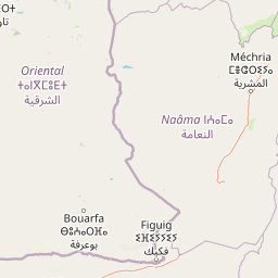
Map view of Djebel Aissa National Park

Use this park location map to pinpoint Djebel Aissa National Park in Algeria, understand its exact geographic position, and read its mapped placement within the surrounding landscape more clearly.

Pigeon | © OpenStreetMap contributors

Location context for Djebel Aissa National Park

Naâma
Park atlas

Trace the regional spread of protected landscapes and compare ecosystems within Algeria's Western Highlands.

Explore Nearby National Parks and Protected Areas Surrounding Djebel Aissa National Park

Discover other national parks and protected areas near Djebel Aissa National Park, exploring a network of conservation landscapes within Algeria's Saharan Atlas region. This comparative view enhances understanding of regional conservation efforts and the distinct characteristics of each protected landscape.
National parkTlemcen Province
About 235 km away#1 closest

North

Tlemcen National Park National Park: Mapped Boundaries and Regional Geographic Context

Discover protected landscapes within Tlemcen Province.

Delve into Tlemcen National Park, an important protected landscape situated within Tlemcen Province. This detail page offers a focused exploration of its specific geographic identity, mapped park boundaries, and the natural terrain it encompasses, providing essential context for understanding its role in regional geography and protected land exploration within Algeria.

Area
82.25 km²
Established
1993
IUCN
II
Relief
Mixed relief
National parkTaza Province
About 370 km away#2 closest

Northwest

Tazekka National Park: Protected Landscape and Geographic Context in Taza Province

Discover its national park status and mapped terrain.

Tazekka National Park serves as a vital protected area within the geographic framework of Taza Province, Morocco. This national park offers a distinct landscape for exploration, allowing users to investigate its mapped boundaries and regional natural features. Understand the park's role in the local geography and its contribution to Morocco's atlas of protected lands. Its specific terrain and setting make it a key point for structured geographic discovery.

Area
120 km²
Established
1950
IUCN
II
Relief
Mountain
National parkAlgeria
About 376 km away#3 closest

Northeast

Théniet El Had National Park: Atlas Cedar Forests in Algeria's Tell Atlas Mountains

Discover protected montane landscape and regional geography.

Théniet El Had National Park represents a significant protected landscape in Algeria, characterized by its towering Atlas cedar forests and dramatic mountainous terrain within the Tell Atlas range. Spanning elevations from 1,200 to over 2,200 meters, this national park offers a distinct example of Mediterranean mountain ecosystems. Its unique forest cover and rugged topography provide crucial habitat and watershed functions, making it a key location for understanding protected area geography and landscape context in North Africa.

IUCN
II
Relief
Mountain
Climate
Mediterranean
Scope
Terrestrial
Watercolor illustration showing a landscape with green hills, vegetation, and distant mountains
National parkMorocco
About 427 km away#4 closest

Northwest

Al Hoceima National Park: Morocco's Coastal and Marine Protected Wilderness

Explore dramatic cliffs, kelp forests, and marine biodiversity.

Al Hoceima National Park represents a significant protected coastal and marine area in northern Morocco, distinguished by its rugged 50-kilometer Mediterranean coastline featuring spectacular limestone cliffs. This national park offers an atlas-style view of a landscape transitioning from the Ibaqouyen Rif mountains to the sea, harboring rich marine biodiversity including significant osprey colonies and dolphin habitats. Discover the mapped extent of this wild protected territory and its unique ecological features.

Area
480 km²
Established
2004
IUCN
II
Relief
Mountain
National parkMorocco
About 438 km away#5 closest

West

Ifrane National Park: Protected Landscape and Geographic Context in Morocco

National park boundaries and mapped terrain.

Investigate Ifrane National Park, a designated national park in Morocco, and its contribution to the country's protected lands. This profile details its geographic location, providing context for its mapped presence and the natural landscapes it encompasses. Delve into the atlas-relevant features that define this protected area, focusing on its geographic identity within Morocco's natural heritage.

Area
500 km²
Established
2004
IUCN
II
Relief
Mountain
National parkMorocco
About 463 km away#6 closest

West

Khenifra National Park: National Park Atlas and Mapped Protected Landscape

Geographic context and protected area mapping for Morocco.

Explore the atlas perspective of Khenifra National Park, a designated national park in Morocco. This page provides detailed geographic context, focusing on its mapped protected landscape and its role within the country's network of conservation areas. Understand the park's terrain and regional setting through structured geographic data.

Area
842 km²
Established
2008
Relief
Mountain
Climate
Mediterranean
National parkMorocco
About 468 km away#7 closest

West

Haut Atlas Oriental National Park: National Park Mapping and Protected Landscape Identity

Explore its mapped geography and regional atlas context.

Delve into the specifics of Haut Atlas Oriental National Park, a designated national park in Morocco. This page serves as a detailed atlas entry, focusing on the park's protected landscape characteristics, its defined geographic boundaries, and its significance within the national park system. Understand the terrain and regional context that shape this important natural area for focused discovery.

Area
490 km²
IUCN
II
Relief
Mountain
Climate
Alpine
Watercolor painting showing a landscape with green mountains, a river, and trees
National parkMorocco
About 493 km away#8 closest

Northwest

Talassemtane National Park: Morocco's Premier Protected Landscape and Geographic Atlas Entry

Explore its mapped boundaries and natural terrain.

Talassemtane National Park is a vital protected area contributing to the geographic diversity of Morocco. This entry focuses on its identity as a national park, detailing its mapped boundaries and providing context within the broader atlas of protected lands. Discover the specific geographic and landscape characteristics that define this Moroccan national park, offering a unique lens for regional exploration.

Area
589.5 km²
Established
2004
IUCN
II
Relief
Mountain

Common questions about visiting, size, designation, and location context for Djebel Aissa National Park

Djebel Aissa National Park FAQs for park facts, access, geography, and protected area context

Find quick answers about Djebel Aissa National Park, including protected-area facts, park geography, trail and visitor context, and how the park fits into its surrounding country and regional landscape.
MoriAtlas Explorer

Continue Your Protected Areas Search Across the Global Atlas

Deepen your exploration by continuing the structured search for national parks and protected areas worldwide. Utilize the comprehensive filtering capabilities to compare different conservation landscapes and refine your understanding of global park geography. Discover more about the distribution and characteristics of protected natural areas.

Global natural geography