Mori Atlas logo
Marine protected areaEast Coast Ngaraad Marine Conservation Area

Map and geographic overview of protected marine ecosystems along the northern Babeldaob coastline

East Coast Ngaraad Marine Conservation Area: A Coastal Marine Protected Area in Palau

The East Coast Ngaraad Marine Conservation Area stands as a vital protected landscape along the eastern edge of Ngaraard State in northern Babeldaob. This marine zone encompasses the critical transition between dense tropical rainforest watersheds and the vibrant coral reef systems of the Pacific. By safeguarding this coastal interface, the area plays a essential role in the broader conservation network of Palau, preserving nearshore biodiversity and the natural ecological processes that link island terrain to surrounding marine habitats.

marine conservation areacoral reefcoastalPacific islandstropicalPalau

East Coast Ngaraad Marine Conservation Area

Marine protected area

Park overview

Structured park overview, official facts, and landscape profile for East Coast Ngaraad Marine Conservation Area

East Coast Ngaraad Marine Conservation Area park facts, protected area profile, and essential visitor context

Review the core facts for East Coast Ngaraad Marine Conservation Area, including designation, size, terrain, visitor scale, habitats, and operating context in one park-focused overview.

About East Coast Ngaraad Marine Conservation Area

The East Coast Ngaraad Marine Conservation Area is a designated nature reserve located along the eastern coast of Ngaraard State, in the northern part of the Republic of Palau. Ngaraard is one of Palau's traditional states situated on Babeldaob, the largest and most heavily forested island in the Palauan archipelago, which lies in the western Pacific Ocean. The protected area forms part of the country's extensive system of marine and coastal conservation zones, reflecting Palau's longstanding national emphasis on preserving its marine environment for both ecological and cultural reasons.

Palau is globally recognized for its rich marine biodiversity, including some of the healthiest coral reef systems remaining in the tropical Pacific. The country's protected area network extends across its islands, lagoon waters, and reef ecosystems, and the East Coast Ngaraad Marine Conservation Area represents one of the localized coastal reserves within that framework. Its position along the eastern shore of northern Babeldaob means it sits at the transition between terrestrial and marine environments, where forested land drains into nearshore waters that support coral reefs and associated marine life.

The climate of the region is tropical maritime, with consistently warm temperatures and substantial rainfall throughout the year. Average annual temperatures hover around 23 degrees Celsius, while rainfall totals are extremely high, frequently surpassing 3,700 millimeters annually. This combination of warmth and abundant moisture drives the productivity of both Palau's rainforests and its reef ecosystems, and reinforces the importance of protecting coastal watersheds and nearshore marine habitats in tandem.

Although small in geographic scope compared with some of Palau's larger marine protected areas, the East Coast Ngaraad Marine Conservation Area plays a meaningful role in the country's conservation landscape by contributing to habitat connectivity, protecting reef-associated species, and supporting the traditional subsistence and cultural practices of local communities who continue to rely on healthy coastal ecosystems. The reserve exemplifies Palau's broader environmental ethos, in which marine protection is treated not only as a biodiversity strategy but also as a central element of national identity and stewardship of the sea.

Quick facts and research context for East Coast Ngaraad Marine Conservation Area

The East Coast Ngaraad Marine Conservation Area is a protected nature reserve situated along the eastern coastline of Ngaraard State in the Republic of Palau. It sits within the tropical maritime climate zone characteristic of Palau's northern islands, where average temperatures remain around 23 degrees Celsius throughout the year and annual rainfall is among the highest in the country, often exceeding 3,700 millimeters.

The area falls within the northern portion of Babeldaob, Palau's main island, and is part of the national system of marine conservation zones that the Republic of Palau has established to protect reef habitats, coastal waters, and associated biodiversity. Its low elevation and coastal position place it directly within the interface between tropical forest catchments and nearshore marine ecosystems.

Protection and recognition

Examine the documented marine protection scope and formal recognition history for this reserve.

East Coast Ngaraad Marine Conservation Area Protection Status and Regional Designations

Marine protection status records for East Coast Ngaraad Marine Conservation Area outline the documented management scope and territorial designation framework. Structured conservation facts provide verified administrative parameters for this protected area.

Protection details

Protection scope
Marine
Transboundary protection
No
Park context

Deeper park guide and search-rich context for East Coast Ngaraad Marine Conservation Area

East Coast Ngaraad Marine Conservation Area history, landscape, wildlife, and travel context

Explore East Coast Ngaraad Marine Conservation Area through its history, landscape character, ecosystems, wildlife, conservation priorities, cultural context, and seasonal travel timing in a structured park guide built for atlas discovery and search intent.

Why East Coast Ngaraad Marine Conservation Area stands out

East Coast Ngaraad Marine Conservation Area is best known for its role as a coastal marine protected area along the eastern edge of Ngaraard State in northern Babeldaob. The area represents Palau's broader commitment to safeguarding tropical reef and shoreline ecosystems through a system of geographically distributed marine reserves. Its defining character comes from its setting within the tropical Pacific environment of Palau, where warm waters, heavy rainfall, and lush forested watersheds combine to support one of the most biodiverse marine regions in the world. The conservation area contributes to protecting coral reef habitat, nearshore marine species, and the coastal ecological processes that link Palau's forests to its reefs.

East Coast Ngaraad Marine Conservation Area landscape and geographic character

The landscape of the East Coast Ngaraad Marine Conservation Area is defined by its coastal position along eastern Ngaraard State, where the forested interior of northern Babeldaob meets the Pacific Ocean. The terrain at this coastal interface is low-lying, sitting close to sea level, and transitions from dense tropical rainforest down to rocky and reef-fringed shoreline.

Babeldaob itself is characterized by rugged volcanic topography covered in thick tropical vegetation, with rivers and streams carrying heavy rainfall runoff toward the coast. At the eastern edge of Ngaraard, this runoff meets warm tropical seawater, shaping a nearshore environment where fringing reefs, lagoon margins, and coastal vegetation interact. The low elevation of the conservation area, recorded at roughly one meter in places, places it firmly within the coastal zone, making it a transition landscape between land and sea.

East Coast Ngaraad Marine Conservation Area ecosystems, habitats, and plant life

The ecological character of the East Coast Ngaraad Marine Conservation Area is shaped by the tropical Pacific environment of northern Palau. The region falls within a tropical maritime climate, supporting both dense rainforest on land and highly productive marine ecosystems offshore. The heavy annual rainfall, often exceeding 3,000 to 3,700 millimeters, sustains lush vegetation in the Ngaraard watershed and delivers nutrients and freshwater inputs to nearshore waters.

Coral reefs and associated marine habitats dominate the ecological identity of Palau's coastal zone. The waters around Ngaraard's eastern coast are part of the larger reef and lagoon system that gives Palau its global reputation for marine biodiversity. These nearshore ecosystems support reef-building corals, reef-associated fish, invertebrates, and a wide variety of marine organisms, while the adjacent forests provide essential terrestrial habitat that influences water quality and sediment flows reaching the reef.

The combination of warm stable sea temperatures, nutrient-rich runoff from forested watersheds, and Palau's geographic isolation has historically allowed reef ecosystems in the region to maintain high species diversity and ecological resilience, making coastal marine conservation areas like the East Coast Ngaraad reserve particularly important for long-term ecological health.

East Coast Ngaraad Marine Conservation Area wildlife and species highlights

While detailed wildlife inventories for the East Coast Ngaraad Marine Conservation Area are not extensively documented, the area falls within a region known globally for exceptional marine biodiversity. The nearshore reef and coastal habitats typical of Palau's eastern Babeldaob coast support a wide range of reef fish, coral species, sharks, rays, marine invertebrates, and sea turtles that are characteristic of Micronesian reef ecosystems.

The adjacent terrestrial environment of Ngaraard supports tropical Pacific island fauna, including forest birds, fruit bats, crustaceans, and other island wildlife typical of Palau's undisturbed rainforest landscapes. The combination of marine and terrestrial habitats in this transition zone means the conservation area potentially sustains both reef-dependent and land-based species, contributing to the broader biodiversity profile of northern Babeldaob.

East Coast Ngaraad Marine Conservation Area conservation status and protection priorities

As a formally designated nature reserve within the Republic of Palau, the East Coast Ngaraad Marine Conservation Area contributes to the country's large and globally recognized system of marine protected areas. Palau has been a leader in marine conservation, establishing some of the world's most extensive shark sanctuaries and reef protection frameworks, and locally designated conservation areas such as this one complement those broader national efforts.

The conservation value of the area rests on protecting nearshore reef and coastal ecosystems from overfishing, habitat degradation, and pollution, while preserving the ecological connections between Babeldaob's forested watersheds and the marine environment. Maintaining these connections is particularly important in a region where heavy tropical rainfall carries terrestrial runoff into coastal waters, and where reef health depends on the quality of both upstream forests and marine habitat conditions.

East Coast Ngaraad Marine Conservation Area cultural meaning and human context

Ngaraard is one of the traditional states of Palau, and coastal marine resources have long been central to the cultural identity, subsistence practices, and traditional governance of its communities. The establishment of local marine conservation areas reflects a growing convergence between modern conservation frameworks and traditional Palauan practices of stewardship over reef and lagoon resources.

In Palau more broadly, the marine environment is deeply woven into cultural life, traditional fishing customs, and the indigenous concept of preserving the sea for future generations. Conservation areas along state coastlines such as Ngaraard's eastern shore carry significance not only for biodiversity protection but also for sustaining traditional livelihoods and reinforcing cultural values tied to the ocean.

Top sights and standout views in East Coast Ngaraad Marine Conservation Area

The East Coast Ngaraad Marine Conservation Area stands out as a coastal marine reserve on the eastern edge of Ngaraard State, part of Palau's extensive network of marine protected zones. Its defining qualities include a position at the land-sea interface of northern Babeldaob, a tropical maritime climate with exceptionally high rainfall, and the surrounding reef and lagoon habitats that make Palau one of the most biodiverse marine regions on Earth.

The reserve's strongest distinction lies in its role within Palau's conservation system, where small but strategically located coastal marine areas collectively uphold the health of coral reefs, nearshore ecosystems, and traditional fishing grounds that support both biodiversity and local culture.

Best time to visit East Coast Ngaraad Marine Conservation Area

Palau's tropical maritime climate is consistent year-round, with warm temperatures averaging around 23 degrees Celsius in every month. Rainfall patterns show modestly drier conditions in early spring and wetter conditions from late spring into summer, which can affect both visibility in coastal waters and accessibility along the eastern Babeldaob coast.

Visitors interested in reef and marine environments typically find that periods of calmer seas and clearer skies offer the most rewarding conditions for coastal exploration, while wetter months highlight the lushness of the surrounding rainforest and the vibrancy of the watershed-to-reef ecological system that defines the region.
Monthly climate preview

Long term temperature ranges and daily precipitation patterns recorded across representative coordinates

East Coast Ngaraad Marine Conservation Area Climate Normals and Monthly Weather Records

Representative coordinate data reveals steady long term temperature averages alongside fluctuating monthly precipitation rates across the conservation area. Exploring the complete twelve month profile provides granular baseline records for deeper environmental analysis.
Annual mean28 °C
28 °C28 °C
Jan28°
Feb28°
Mar28°
Apr28°
May28°
Jun28°
Jul28°
Aug28°
Sep28°
Oct28°
Nov28°
Dec28°
Warmest month
May

28.3 °C

Coolest month
February

27.5 °C

Wettest month
July

11.9 mm/day

Driest month
March

5.7 mm/day

Park location guide

Geography guide, regional context, and park location map for East Coast Ngaraad Marine Conservation Area

East Coast Ngaraad Marine Conservation Area park geography, regions, and map view in Palau

Understand where East Coast Ngaraad Marine Conservation Area sits in Palau through a broader geographic reading of the surrounding landscape, nearby location context, and its mapped position within the national park landscape.

How East Coast Ngaraad Marine Conservation Area fits into Palau

Palau is a sovereign island nation located in the western Pacific Ocean within the Micronesia subregion of Oceania. The country consists of roughly 340 islands forming part of the Caroline Islands chain. It achieved full independence in 1994 through a Compact of Free Association with the United States, having previously been under Spanish, German, Japanese, and US administration.

Wider geography shaping East Coast Ngaraad Marine Conservation Area in Palau

Palau is located in the western Pacific Ocean as part of the Caroline Islands in the Micronesia region of Oceania. The archipelago sits near Indonesia to the south, the Philippines to the northwest, and the Federated States of Micronesia to the east. The largest island is Babeldaob, where the capital Ngerulmud is located in Melekeok State.

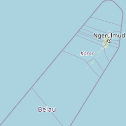
Map view of East Coast Ngaraad Marine Conservation Area

Use this park location map to pinpoint East Coast Ngaraad Marine Conservation Area in Palau, understand its exact geographic position, and read its mapped placement within the surrounding landscape more clearly.

Pigeon | © OpenStreetMap contributors

Location context for East Coast Ngaraad Marine Conservation Area

Ngaraard
Park atlas

Compare surrounding regional marine reserves and protected tropical coastlines

Explore Parks Near East Coast Ngaraad Marine Conservation Area

Browse other protected areas near East Coast Ngaraad Marine Conservation Area to examine connected reef ecosystems and coastal habitats across northern Babeldaob. Comparing adjacent marine reserves provides wider geographic context for regional conservation networks throughout the tropical Pacific.
Watercolor painting of a calm lake surrounded by lush green hills, with reeds in the foreground and overhanging branches at the top.
Nature reserveMelekeok
About 15 km away#1 closest

South

Lake Ngardok Nature Reserve: Mapped Protected Area and Freshwater Geography in Melekeok

Protected wetland landscapes of central Babeldaob Island

Lake Ngardok serves as a landmark freshwater reserve in Melekeok, featuring extensive marshlands and a connected river drainage system. As a protected watershed on Babeldaob Island, the area offers significant insights into Pacific island freshwater ecology, providing a stable habitat within a dense tropical forest catchment for diverse endemic species and rare wildlife.

Area
4.93 km²
Established
2002
Water
Water-dominated
Protected areaPalau
About 18 km away#2 closest

Northwest

Ebiil Channel Conservation Area: Geographic Map and Protected Marine Landscape Profile

Coastal conservation mapping in northern Palau

Examine the physical geography and protected maritime boundaries of the Ebiil Channel Conservation Area. This site highlights the coastal transition zones between land and sea in northern Palau, providing essential context for the reef-based topography and marine reserves of the archipelago.

Water
Water-dominated
Nature reserveState of Ngeremlengui
About 22 km away#3 closest

Southwest

Bkulabeluu Conservation Area: Inland Forest Nature Reserve in Ngeremlengui, Palau

Mapped protected landscapes of northern Babeldaob

Deepen your understanding of Bkulabeluu Conservation Area, a significant nature reserve situated in the interior highlands of the State of Ngeremlengui. This atlas entry details the volcanic ridges, tropical rainforest vegetation, and watershed connectivity that define the protected landscape of Babeldaob island, serving as a cornerstone for terrestrial conservation in Palau.

Nature reserveState of Airai
About 35 km away#4 closest

South

Airai State Conservation Area: Protected Forest and Watershed Geography in the State of Airai

Nature reserve on Babeldaob Island, Palau

Located in the State of Airai on Babeldaob Island, this nature reserve protects native forest and watershed headwaters. The area is a key example of state-level terrestrial conservation in Palau, providing essential inland habitat and contributing to the island's overall ecological health through its managed landscape boundaries.

Relief
Lowland
A watercolor painting showing a panoramic view of green islands surrounded by calm, light blue water under a soft pink and yellow sunrise or sunset sky.
Marine protected areaKoror
About 59 km away#5 closest

Southwest

Rock Islands: Protected Marine Landscape and Limestone Archipelago Mapping

Geographic analysis of the reef-derived island system in Koror, Palau.

The Rock Islands consist of hundreds of limestone outcrops scattered across the Southern Lagoon, forming a mosaic of vegetated caps and narrow intertidal notches. This atlas entry provides a structured look at the archipelago's protected boundaries, marine lagoon features, and the unique geology that distinguishes these island landforms in the western Pacific.

Area
41.12 km²
Established
2012
Relief
Lowland
Climate
Tropical
Marine protected areaYap
About 432 km away#6 closest

Northeast

Nimpal Channel Marine Conservation Area: Geography and Protected Marine Landscapes in Yap

Community-managed coastal reefs and tidal mangrove systems

Located in Yap, the Nimpal Channel Marine Conservation Area functions as a protective node for local reef ecosystems. This 77-hectare reserve serves as a model for community-based stewardship, linking the health of mangrove-fringed shorelines with the resilience of the surrounding tidal channel habitats in the western Pacific.

Area
0.77 km²
Relief
Lowland
Climate
Tropical
Access
Access unknown
Marine protected areaDavao Oriental
About 932 km away#7 closest

West

Pujada Bay Protected Seascape: Marine Protected Area and Coastal Landscape in Davao Oriental

Coastal geography and protected marine ecosystems of Mindanao

Pujada Bay Protected Seascape serves as a primary coastal sanctuary along the Davao Oriental shoreline. Defined by the convergence of mountain-fed rivers, mangrove forests, and coral reef habitats within a semi-enclosed bay, this protected area offers a deep look into the marine geography of the Philippine archipelago.

Area
212 km²
Established
1994
Relief
Mixed relief
Access
Access unknown
Wildlife reserveAgusan del Sur
About 971 km away#8 closest

West

Agusan Marsh Wildlife Sanctuary: Mapping a Vast Freshwater Protected Area

Swamp forests and river basin geography in Agusan del Sur

Agusan Marsh Wildlife Sanctuary represents a crucial freshwater wetland complex within the Agusan River basin. The area is defined by its expansive swamp forests and semi-permanent floating lakes, which serve as essential migratory transit points and support an intricate network of aquatic ecosystems across the Mindanao region.

Area
148.36 km²
Established
1996
IUCN
IV
Relief
Lowland

Common questions about visiting, size, designation, and location context for East Coast Ngaraad Marine Conservation Area

East Coast Ngaraad Marine Conservation Area FAQs for park facts, access, geography, and protected area context

Find quick answers about East Coast Ngaraad Marine Conservation Area, including protected-area facts, park geography, trail and visitor context, and how the park fits into its surrounding country and regional landscape.
MoriAtlas Explorer

Continue Your Protected Areas Search Across the Global Atlas

Deepen your exploration by continuing the structured search for national parks and protected areas worldwide. Utilize the comprehensive filtering capabilities to compare different conservation landscapes and refine your understanding of global park geography. Discover more about the distribution and characteristics of protected natural areas.

Global natural geography