Mori Atlas logo
Nature reserveEbenberg

Examining the ecological boundaries and landscape terrain of this protected German nature reserve

Ebenberg Nature Reserve: A Detailed Geographic Atlas of Protected Loess Grassland Habitats

(Naturschutzgebiet Ebenberg)

Ebenberg is a distinctive protected nature reserve rising above the Upper Rhine Plain in Landau in der Pfalz, Germany. This mapped landscape features a rare complex of nutrient-poor and semi-dry grasslands on loess soils, bordered by natural streams and regional transport corridors. Through its historical military heritage and ongoing ecological stewardship, the reserve now provides vital habitat for native birds, bats, and rare orchid species across its open, semi-open terrain.

nature reserveloess grasslandnutrient-poor grasslandsemi-dry grasslandhedgerowsshrubland

Ebenberg

Nature reserve

Park overview

Structured park overview, official facts, and landscape profile for Ebenberg

Ebenberg park facts, protected area profile, and essential visitor context

Review the core facts for Ebenberg, including designation, size, terrain, visitor scale, habitats, and operating context in one park-focused overview.

About Ebenberg

Ebenberg is a small but ecologically important hill and protected landscape in the southern outskirts of Landau in der Pfalz, a town in the southern part of Rhineland-Palatinate. Although modest in height at around 160 meters above sea level, the hill occupies a meaningful ecological niche in an otherwise heavily cultivated region of the Upper Rhine Plain. Its position, bordered by the Birnbach creek to the north, the B 38 federal road to the south, and the Neustadt-Wissembourg railway line to the east, gives the site clearly defined boundaries that have helped preserve its near-natural character.

The area is primarily protected under the designation Naturschutzgebiet Ebenberg, with the official code NSG-7313-200. Following its designation on 3 November 1999, the reserve has been managed by DBU Naturerbe GmbH, a German conservation organization. The protection ordinance emphasizes the preservation and development of the Ebenberg as a near-natural area, with particular attention to large open-land habitats such as nutrient-poor and semi-dry grasslands, native shrub communities, hedgerows, field copses, tree groups, and individual trees.

What sets Ebenberg apart from many other small protected areas in the region is the unusual continuity and scale of its open habitats on loess soils. The soils produce specific, often species-rich grassland communities that have become increasingly rare across Germany. Through a combination of designation, ongoing grazing with sheep, and natural succession in targeted zones, the reserve is intended to maintain both open and lightly wooded habitats over the long term.

Visitors familiar with German nature reserves will find that Ebenberg combines ecological value with cultural history. The hill once served as a military training area and was associated with Nike and later Patriot air defense installations, all of which have left traces in the landscape. Today, parts of the area also host the Segelfluggelände Landau-Ebenberg, a gliding airfield, reflecting the ongoing balance between conservation, recreation, and the site's layered human history.

Quick facts and research context for Ebenberg

Ebenberg Nature Reserve is a protected area of roughly 217 hectares located in Landau in der Pfalz, Rhineland-Palatinate. It was officially designated as a nature reserve by the Bezirksregierung Rheinhessen-Pfalz on 3 November 1999 and is administered by DBU Naturerbe GmbH. The site is simultaneously classified as an FFH (Fauna-Flora-Habitat) area, reflecting its European ecological significance.

The protected landscape centers on a 160 meter hill built on loess soils, featuring large areas of nutrient-poor and semi-dry grassland, native hedgerows, scrub, scattered trees, and naturally developing woodland. The reserve is particularly noted for hosting rare orchid species and serves as habitat for rare bird species and bats. Traditional sheep grazing is used as a key management tool to maintain the open grassland communities.

Protection and recognition

Terrestrial protection scope and official designation records established in 1999

Ebenberg Protection Status and Designated Conservation History

Ebenberg maintains documented terrestrial protection status established in the year 1999. Structured conservation records outline the official management scope and designation history for this protected area.

Protection details

Protection scope
Terrestrial
Designated year
1999
Park context

Deeper park guide and search-rich context for Ebenberg

Ebenberg history, landscape, wildlife, and travel context

Explore Ebenberg through its history, landscape character, ecosystems, wildlife, conservation priorities, cultural context, and seasonal travel timing in a structured park guide built for atlas discovery and search intent.

Why Ebenberg stands out

Ebenberg is best known for its unusually large and coherent complex of near-natural open habitats on loess soils within a lowland setting. The reserve contains extensive areas of Magerrasen (nutrient-poor grassland) and Halbtrockenrasen (semi-dry grassland), embedded among native hedgerows, field copses, single trees, and patches of developing woodland. This mosaic of habitat types on a single hill is uncommon in the intensively farmed Upper Rhine Plain and gives the site its main ecological identity. The reserve is also valued for the rare orchid species documented in its grazed grasslands, including Pyramidenorchis and Bocks-Riemenzunge, and for its role as a refuge for rare birds and bats tied to these open and semi-open habitats. Together, these features place Ebenberg firmly within the network of valuable lowland loess grassland reserves in southwestern Germany.
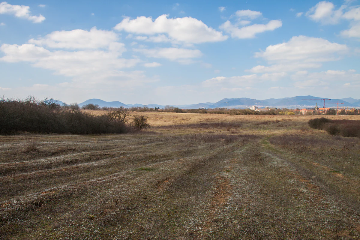
A wide, eye-level landscape shot of a dry, brownish field under a bright, partly cloudy sky, with distant hills visible on the horizon.
A wide view of the dry, open grasslands of the Ebenberg nature reserve in Landau.

Ebenberg history and protected-area timeline

The history of Ebenberg is closely tied to military and agricultural use. In 1828, the hill was a 25 hectare pasture in military ownership, indicating that the area had already been drawn into state-controlled land use in the early nineteenth century. After the Second World War, the surrounding ground was expanded to approximately 230 hectares and used by French occupation forces as a military training area, profoundly shaping the openness of the landscape and limiting agricultural intensification.

Between the postwar period and 1983, the site hosted a Nike surface-to-air missile battery, which was subsequently converted into a Patriot air defense installation. The Patriot position remained in operation until 1994. The withdrawal of military activity created an opportunity for ecological protection, and the transition from military用地 to conservation reserve is one of the defining chapters of the area's modern history.

In 1999, the hill was formally designated as the Naturschutzgebiet Ebenberg, recognizing its value as a near-natural area and locking in legal protection for its habitats. Since then, management has been carried out by DBU Naturerbe GmbH. The hill's ongoing use as the Segelfluggelände Landau-Ebenberg gliding airfield shows how the continued sporting and recreational use of the site has been reconciled with its protected status.

Ebenberg landscape and geographic character

The Ebenberg is a low hill rising to approximately 160 meters above sea level in the southwestern part of Landau in der Pfalz. Its elevation may be modest, but it is conspicuous within the surrounding flat terrain of the Upper Rhine Plain. The hill is built on loess, a fine, wind-blown sediment that in this region produces distinctive soils supporting specific grassland communities.

Geographically, the hill is framed by clear natural and infrastructural boundaries. The Birnbach, a small tributary of the Queich, runs along the northern side, while the B 38 federal road defines the southern edge and the Pfälzische Maximiliansbahn railway forms part of the eastern boundary. These edges together create a well-defined landscape unit that is clearly distinct from the surrounding agricultural lowland.

The visual character of the Ebenberg combines open grassland, scattered shrubs, hedgerows, individual trees, and patches of woodland. The openness of much of the terrain is itself a defining element of the landscape, a legacy of long military use that prevented the area from being afforested or heavily farmed. Today, the combination of gentle relief, loess soils, structural diversity, and openness gives the area a sense of openness unusual for a hill reserve in this part of Germany.

Ebenberg ecosystems, habitats, and plant life

Ecologically, Ebenberg is dominated by a mosaic of open and semi-open habitats on loess-derived soils. The most characteristic biotopes are extensive Magerrasen, or nutrient-poor grasslands, and Halbtrockenrasen, or semi-dry grasslands, which together form large continuous areas of open land. These grasslands are interspersed with native shrub communities, hedgerows, field copses, tree groups, and solitary trees, creating structural diversity that is central to the site's ecological value.

In addition to the open habitats, the reserve contains areas of developing woodland, including successional patches that are intentionally left to develop naturally. These wooded zones provide a contrast to the open grassland and contribute to the site's habitat mosaic. The combination of open, semi-open, and lightly wooded habitats is a deliberate focus of the protection ordinance, which seeks both to conserve existing near-natural areas and to allow natural succession where appropriate.

The site's FFH designation underscores the European significance of these habitat complexes, particularly the loess grasslands and their associated fauna and flora. The reserve's overall ecological identity is that of a large, ecologically coherent lowland grassland and shrub landscape embedded within an otherwise intensively used agricultural plain.

Ebenberg wildlife and species highlights

The wildlife value of Ebenberg is closely tied to its open and semi-open loess grassland habitats. The reserve is explicitly identified in its protection ordinance as important habitat for rare bird species and bats, both of which rely on the structural diversity created by grassland, scrub, hedgerows, scattered trees, and field copses.

The combination of nutrient-poor and semi-dry grasslands, hedgerows, and small woodland patches creates a range of nesting, foraging, and roosting opportunities for birdlife. Bats, in particular, benefit from the interface between open hunting grounds and tree-rich edge habitats. The reserve's FFH status reflects this broader faunal significance at the European level.

Beyond birds and bats, the diverse grassland and shrub mosaic supports a typical fauna of lowland warm-loving insects and other invertebrates associated with near-natural grassland, which in turn underpin food webs for birds and small mammals. While specific species lists are kept light here, the reserve's overall wildlife character is one of a richly structured lowland refuge rather than a single-species focus.

Ebenberg conservation status and protection priorities

From a conservation perspective, Ebenberg matters primarily because it preserves an unusually large and contiguous block of near-natural open habitat on loess soils. Such loess-derived grassland complexes have become increasingly rare across Germany and Central Europe as a whole, having been lost to agricultural intensification, afforestation, or development. The reserve therefore plays a role in safeguarding a habitat type that is regionally and, through its FFH status, internationally significant.

The protection ordinance emphasizes both preservation and active development, indicating that the reserve is not treated as a static museum landscape but as a dynamic system. Open grassland is to be retained and developed, while other areas are allowed to undergo natural succession into woodland. Traditional sheep grazing is used to maintain the open grassland communities, particularly those that support rare orchid species such as Pyramidenorchis and Bocks-Riemenzunge.

Management by DBU Naturerbe GmbH, a conservation organization linked to the Deutsche Bundesstiftung Umwelt, has brought a stable long-term stewardship framework to the area. The reserve's FFH designation adds another layer of protection and connects Ebenberg to the wider European Natura 2000 network, ensuring that its conservation value is recognized beyond regional policy alone.

Ebenberg cultural meaning and human context

The cultural context of Ebenberg is shaped by the long interplay between the landscape and various forms of human use. For centuries the hill was part of the agricultural and pastoral fabric of the Pfalz region, but in the early nineteenth century it entered a different phase of use when it was taken over as military-owned pasture land in 1828.

The twentieth century brought a much heavier military presence. The hill served as a training ground for French forces after the Second World War and hosted successive air defense installations, first Nike and then Patriot, between the postwar years and 1994. This military period both shaped the openness of the landscape and delayed its transition to formal nature conservation.

In more recent decades, parts of the hill have returned to civilian use. The Segelfluggelände Landau-Ebenberg gliding airfield reflects the area's ongoing role as a recreational space, while the 1999 designation as a nature reserve formalizes its ecological role. Local clubs, including the Aero-Club Landau and DJK Landau, remain connected to the site's contemporary use, underlining the layered relationship between people, sport, and conservation on this single hill.

Top sights and standout views in Ebenberg

Ebenberg stands out for the unusual scale and coherence of its loess grassland habitats within the Upper Rhine Plain. Its combination of nutrient-poor and semi-dry grasslands, native hedgerows, scrub, and developing woodland creates one of the more substantial near-natural open-land complexes in the region.

Equally notable is the reserve's layered history, which includes nineteenth-century military pasture use, postwar troop training ground status, and the presence of Nike and Patriot air defense installations. The eventual transition from a military landscape to a protected nature reserve with DBU Naturerbe stewardship is one of its defining modern stories.

The presence of rare orchid species in grazed grassland and the site's status as an FFH area further reinforce its conservation credentials, while the coexistence of the nature reserve and the Segelfluggelände Landau-Ebenberg gliding airfield shows how ecological protection is balanced with contemporary recreational use.

Best time to visit Ebenberg

The character of Ebenberg changes gently with the seasons in ways that echo its grassland ecology. Late spring and early summer are particularly rewarding for visitors interested in the reserve's rare orchids and the flowering richness of its semi-dry grasslands, when loess grasslands typically reach their peak botanical diversity. Early mornings and evenings during this period also tend to be the most comfortable times to experience bird and bat activity around the hedgerows and field edges.

Late summer and early autumn bring warmer, drier conditions that emphasize the open, almost steppe-like character of the Magerrasen and Halbtrockenrasen, and are also a period when grazing sheep are visibly active across the reserve. Winter visits can offer quieter, more atmospheric conditions, with bare deciduous trees giving clearer views across the landscape and the surrounding plains.

Because the area combines a nature reserve with an active gliding airfield, visitors interested primarily in ecological or scenic experience may prefer times outside of peak airfield operations, especially when seeking a quiet walk through the reserve.


Monthly climate preview

Long-term representative point measurements for average monthly temperature and precipitation cycles

Ebenberg Climate Normals and Measured Annual Temperature and Precipitation Rhythm

Representative baseline coordinates record long-term monthly temperature and precipitation normals across the protected terrain. Accessing the complete monthly profile provides detailed historical temperature ranges and precipitation metrics for structured analysis.
Annual mean10 °C
1 °C21 °C
Jan
Feb
Mar
Apr10°
May15°
Jun19°
Jul21°
Aug20°
Sep16°
Oct10°
Nov
Dec
Warmest month
July

20.9 °C

Coolest month
January

0.6 °C

Wettest month
May

2.3 mm/day

Driest month
April

1.5 mm/day

Park location guide

Geography guide, regional context, and park location map for Ebenberg

Ebenberg park geography, regions, and map view in Germany

Understand where Ebenberg sits in Germany through a broader geographic reading of the surrounding landscape, nearby location context, and its mapped position within the national park landscape.

How Ebenberg fits into Germany

Germany is a federal republic in Western and Central Europe with a population of over 83 million across sixteen constituent states. It is Europe's largest economy by nominal GDP and a major global exporter and importer. The capital is Berlin, and the country borders Denmark, Poland, Czech Republic, Austria, Switzerland, France, Luxembourg, Belgium, and the Netherlands.

Wider geography shaping Ebenberg in Germany

Germany is located in Western and Central Europe, spanning 357,022 km². It borders Denmark to the north, Poland and the Czech Republic to the east, Austria and Switzerland to the south, and France, Luxembourg, Belgium, and the Netherlands to the west. The country has coastlines on the Baltic Sea and North Sea to the north, with the Alps located in the southern region.

Map view of Ebenberg

Use this park location map to pinpoint Ebenberg in Germany, understand its exact geographic position, and read its mapped placement within the surrounding landscape more clearly.

Pigeon | © OpenStreetMap contributors

Location context for Ebenberg

Rhineland-Palatinate

Visual reference guide to loess grasslands, terrain, and habitats

Ebenberg Photos, Scenery, and Protected Landscape Views

Visual documentation captures the open loess grasslands, shrub mosaics, and distinctive hill terrain defining the protected reserve. Photographic records reveal the ecological character and environmental features shaping the protected landscape.

A wide, eye-level landscape shot of a dry, brownish field under a bright, partly cloudy sky, with distant hills visible on the horizon.

Park atlas

Compare adjacent lowland reserves and connected regional landscapes

Parks Near Ebenberg and Protected Areas Across the Surrounding Region

Browse nearby national parks and protected areas sharing similar loess terrain and regional ecology. Expanding the geographic scope allows deeper comparison of protected landscapes across the Upper Rhine Plain.
A soft, light watercolor painting of a rolling rural landscape featuring rows of vineyards in the foreground and tree-covered hills in the distance.
Nature reserveRheinland-Pfalz
About 7.9 km away#1 closest

North

Haardtrand Nature Reserve: Geographic Overview and Protected Landscape Mapping

Bird protection area within the Rheinland-Pfalz region.

Spanning roughly 14,700 hectares, Haardtrand serves as a critical link between the Palatinate Forest and the Rhine valley. This nature reserve is composed of a distinctive mosaic of habitat types, including mature broadleaf woodlands, traditional orchard meadows, and sandy terraces, which together create a highly structured environment for diverse raptors and forest-dwelling bird species.

Area
147.28 km²
Established
2004
Nature reserveRhineland-Palatinate
About 13 km away#2 closest

East

Bellheimer Wald: Protected Alluvial Forest and Inland Dune Geography in Germany

Nature reserve landscapes in Rhineland-Palatinate

Bellheimer Wald offers a window into the unique geography of the Upper Rhine Plain. This protected forest is characterized by its sandy alluvial soils and rare inland dune systems, forming a core component of the alluvial-fan woodland chain that spans the southern Palatinate and supports complex habitats for specialized flora and fauna.

Area
46.79 km²
Established
2000
IUCN
IV
Relief
Lowland
Watercolor painting of a tranquil wetland landscape with soft green vegetation and a calm water body, reflecting the floodplain environment of the Rhine river.
Nature reserveLandkreis Germersheim
About 13 km away#3 closest

East

Hördter Rheinaue Nature Reserve: Landscape and Geographic Context in Landkreis Germersheim

Examining the hydrology and floodplain forest of the German Rhine.

Hördter Rheinaue serves as a critical node in the Palatinate Rhine floodplains, preserving a vast mosaic of willow and poplar forests alongside stable hardwood stands. Analyze the mapped terrain shaped by centuries of river activity, including the meandering Michelsbach and associated oxbow systems that define this essential protected corridor in western Germany.

Area
8.18 km²
Established
1966
IUCN
IV
Relief
Lowland
A soft, watercolor painting of a wide landscape with a calm water body in the foreground, rolling green hills in the midground, and purple-toned distant mountains under a pale sky.
Nature reserveRhineland-Palatinate
About 13 km away#4 closest

South

Bruchbach-Otterbachniederung Nature Reserve: Regional Floodplain and Wetland Geography

Mapping protected floodplain habitats along the Upper Rhine.

Bruchbach-Otterbachniederung is a landmark nature reserve in Rhineland-Palatinate, anchoring a continuous corridor of floodplain habitat from Rheinzabern to the French border. This protected area preserves a rare mosaic of reed beds, tall herb communities, and near-natural streams, providing essential sanctuary for regional flora and fauna within the southern Rhine lowlands.

Area
15.432 km²
Established
1988
IUCN
V
Relief
Lowland
A soft, light watercolor painting of a wetland scene with a winding river branch, reeds, and low-lying greenery under a hazy sky.
Nature reserveRheinland-Pfalz
About 16 km away#5 closest

Southeast

Neupotzer Altrhein Nature Reserve: A Detailed Map and Geographic Overview

Protected floodplain landscape in the Rheinland-Pfalz region.

The Neupotzer Altrhein reserve stands as a prominent example of Rhine floodplain recovery, featuring a diverse topography of slow-moving water channels, marshes, and softwood alluvial forests. Located in the Rheinland-Pfalz district of Germersheim, this protected area offers significant insight into the historical and natural shifts of the Rhine corridor, serving as a key refuge within the European Natura 2000 network.

Area
2.375 km²
Established
2000
IUCN
IV
Relief
Lowland
A watercolor painting showing a soft, atmospheric landscape with a foreground of water and green grasses, a midground of trees, and purple mountains in the background under a pale yellow sky.
Nature reserveRhineland-Palatinate
About 16 km away#6 closest

Southeast

Rheinniederung Neuburg-Wörth: A Protected Floodplain Landscape in Rhineland-Palatinate

An analysis of river meanders, oxbows, and floodplain forest geography

This nature reserve encompasses a 14.5 square kilometer corridor of the Upper Rhine, featuring a distinct topography of hardwood forests, wet meadows, and aquatic habitats. The site remains a focal point for understanding Rhine river dynamics and the conservation of rare floodplain ecosystems like the Wörther Altrhein.

Area
14.48 km²
Established
2004
Relief
Lowland
Climate
Temperate
Nature reserveRheinland-Pfalz
About 17 km away#7 closest

Southeast

Wörther Altrhein Nature Reserve: Protected Wetland Atlas and Upper Rhine Landscape Context

Mapped conservation zones within the Rheinland-Pfalz floodplain

Investigate the protected landscape of Wörther Altrhein, an ecologically important former Rhine channel. This site offers a unique study in wetland geography, where controlled hydrology supports diverse reedbeds and alluvial forest habitats within the industrial backdrop of the southern Upper Rhine.

Area
2.4 km²
Established
2004
IUCN
IV
Relief
Lowland
A soft watercolor painting of a low-lying forest landscape with distant gentle hills and a stream in the foreground.
Protected landscapeRhineland-Palatinate
About 17 km away#8 closest

South

Bienwald Protected Landscape: Geographic Atlas and Regional Forest Context

Lowland forest dynamics in southern Rhineland-Palatinate

Bienwald is a distinct protected landscape in western Germany, forming one of the largest contiguous lowland forest complexes. Its geography is shaped by sandy alluvial fans and impermeable sub-layers that drive seasonal flooding patterns, supporting a diverse network of over 300 mapped biotope types across its level, woodland-covered terrain.

Area
120 km²
Established
1987
IUCN
V
Relief
Lowland

Common questions about visiting, size, designation, and location context for Ebenberg

Ebenberg FAQs for park facts, access, geography, and protected area context

Find quick answers about Ebenberg, including protected-area facts, park geography, trail and visitor context, and how the park fits into its surrounding country and regional landscape.
MoriAtlas Explorer

Continue Your Protected Areas Search Across the Global Atlas

Deepen your exploration by continuing the structured search for national parks and protected areas worldwide. Utilize the comprehensive filtering capabilities to compare different conservation landscapes and refine your understanding of global park geography. Discover more about the distribution and characteristics of protected natural areas.

Global natural geography