Mori Atlas logo
National parkEl Cajas National Park

Discover the geography and protected land boundaries of El Cajas National Park in Ecuador.

El Cajas National Park National Park: Ecuador's Mapped Protected Landscape Atlas

(Parque Nacional El Cajas)

El Cajas National Park represents a significant protected area within Ecuador, offering a distinct national park identity for geographic exploration. This canonical MoriAtlas page serves as the primary entry point for understanding the park's mapped boundaries, its unique landscape character, and its placement within the regional geography of South America. Delve into the atlas context of El Cajas National Park to appreciate its role as a protected natural landscape.

Andean páramoHigh-altitude protected areaLakes and lagoonsGlacial landscapeWatershed protectionEcuadorian highlands

El Cajas National Park

National park

Park overview

Structured park overview, official facts, and landscape profile for El Cajas National Park

El Cajas National Park park facts, protected area profile, and essential visitor context

Review the core facts for El Cajas National Park, including designation, size, terrain, visitor scale, habitats, and operating context in one park-focused overview.

About El Cajas National Park

El Cajas National Park was established in 1996 and encompasses an area of approximately 28,544 hectares within the southern Ecuadorian Andes. The park protects the Cajas Massif, a mountainous region of significant geological and ecological importance. The landscape is dominated by the páramo, a unique high-altitude neotropical ecosystem that exists only in the northern Andes of South America. This ecosystem is characterized by its ability to function as a giant sponge, absorbing moisture from clouds and fog and slowly releasing it through streams and rivers, making it critically important for water regulation and catchment. The park's elevation ranges from approximately 3,000 to 4,500 meters above sea level, with the highest peaks reaching around 4,500 meters. The area receives high humidity due to its position in the cloud forest zone, creating persistent fog and mist that contribute to the moisture balance of the páramo system.

Quick facts and research context for El Cajas National Park

El Cajas National Park is situated in the southern Ecuadorian Andes, approximately 30 kilometers west of the city of Cuenca. The park protects a significant portion of the Cajas Massif, a granite mountain range with numerous lakes and ponds formed by glacial activity during the Quaternary period. The area is recognized as a source of vital water resources for the region, with the Tomebamba River originating within the park boundaries. The páramo ecosystem dominates the landscape, characterized by cushion plants, grasses, and shrublands that store water and release it slowly, functioning as a natural water regulation system.

Park context

Deeper park guide and search-rich context for El Cajas National Park

El Cajas National Park history, landscape, wildlife, and travel context

Explore El Cajas National Park through its history, landscape character, ecosystems, wildlife, conservation priorities, cultural context, and seasonal travel timing in a structured park guide built for atlas discovery and search intent.

Why El Cajas National Park stands out

El Cajas is best known for its extensive páramo ecosystem and its network of more than 270 lakes and lagoons scattered throughout the mountainous terrain. The park is considered one of the most important hydrological regulation areas in Ecuador, serving as a critical watershed that supplies water to the city of Cuenca and surrounding agricultural zones. The dramatic scenery of the Cajas Massif, with its rugged peaks, glacial valleys, and mirror-still lakes set against the Andean backdrop, defines the park's identity.

El Cajas National Park history and protected-area timeline

The creation of El Cajas National Park in 1996 marked the formal protection of an area that had long been recognized for its ecological significance and water resource value. Prior to national park designation, the Cajas region had been managed as a forest reserve and had been the subject of conservation discussions for several decades. The establishment of the park responded to growing concerns about the protection of páramo ecosystems and the preservation of the watershed functions critical to the regional water supply. Management of the park falls under the jurisdiction of the Ecuadorian Ministry of Environment, with conservation priorities focused on protecting the hydrological functions of the páramo and maintaining the biodiversity associated with these high-altitude ecosystems.

El Cajas National Park landscape and geographic character

The landscape of El Cajas National Park is defined by the Cajas Massif, a mountainous area of granite peaks and glacial valleys. The terrain is characterized by steep ridges, rocky outcrops, and a remarkable concentration of lakes and ponds, estimated to number more than 270. These water bodies range from small shallow ponds to larger lakes occupying glacial cirques and valleys. The páramo grasslands dominate the higher elevations, while lower slopes may support cloud forest vegetation in more sheltered areas. The overall impression is one of a wild, windswept mountain landscape where water, rock, and vegetation combine to create a distinctive Andean environment. The scenery changes with weather and light, with mists frequently rolling across the lakes and páramo, adding to the atmosphere of the landscape.

El Cajas National Park ecosystems, habitats, and plant life

The páramo ecosystem is the ecological heart of El Cajas National Park. This high-altitude ecosystem is characterized by grasses, dwarf shrubs, and cushion plants that have evolved to survive in the cool, wet conditions of the Andean highlands. The vegetation exhibits adaptations to the harsh environment, including rosette growth forms, tough leathery leaves, and deep root systems that can penetrate the peaty soils. The páramo acts as a critical water regulation system, with its vegetation and soils storing water during wet periods and releasing it gradually through dry seasons. This function makes the páramo ecosystem extremely valuable not only ecologically but also for the water security of downstream communities. The park also includes areas of cloud forest in lower valleys and along watercourses, adding to the ecological diversity of the protected area.

El Cajas National Park wildlife and species highlights

The wildlife of El Cajas reflects the high-altitude Andean environment, with species adapted to the páramo and adjacent habitats. Birdlife includes several species characteristic of Andean grasslands and wetlands, with waterfowl utilizing the numerous lakes. The spectacled bear, South America's only bear species, is present in the park and may be encountered in higher vegetation zones. Mammals such as the mountain tapir and the white-tailed deer also inhabit the area, though sighting these species requires patience and luck given their typically shy behavior. The amphibian population is notable, with several species of frogs and toads breeding in the park's lakes and wetlands. The harsh conditions of the páramo limit the number of large mammals, but the area nonetheless supports a functional community of species adapted to this unique environment.

El Cajas National Park conservation status and protection priorities

El Cajas National Park is recognized as a strategically important protected area for the conservation of páramo ecosystems, which are endemic to the northern Andes and face numerous threats including climate change, infrastructure development, and unsustainable land use practices. The park's conservation significance is amplified by its role as a critical watershed that supplies water to the city of Cuenca, one of Ecuador's largest cities, as well as surrounding agricultural areas. The protection of the páramo is particularly important given its role in carbon storage, water regulation, and biodiversity maintenance. The park is included in the broader network of protected areas in Ecuador and contributes to national and international conservation objectives for high-altitude Andean ecosystems.

El Cajas National Park cultural meaning and human context

The Cajas region has historical significance for local communities in the Cañar province. The area sits within a broader cultural landscape that includes pre-Columbian archaeological sites and traditional agricultural zones. The local communities have historically interacted with the mountain environment, and the water resources originating in the Cajas Massif have supported agriculture and settlement in the surrounding valleys. The establishment of the national park has added a new dimension to the region's identity, positioning the area as a destination for nature-based tourism and environmental education. The park management works with local communities on various initiatives related to sustainable development and conservation awareness.

Top sights and standout views in El Cajas National Park

The páramo landscape of El Cajas, with its extensive wetland systems and dramatic mountain scenery, represents one of the most intact high-altitude ecosystems in Ecuador. The network of over 270 lakes provides outstanding opportunities for experiencing the beauty of Andean wilderness, with each lake offering slightly different perspectives of the surrounding peaks and vegetation. The ecological importance of the páramo as a water regulation system adds scientific and practical significance to the scenic beauty of the park. Visitors traveling to El Cajas experience an environment quite different from the tropical lowlands more commonly associated with Ecuadorian nature tourism, discovering instead the windswept, misty world of the high Andes.

Best time to visit El Cajas National Park

The best time to visit El Cajas National Park is during the dry season from June to September, when rainfall is lower and visitors are more likely to experience clearer conditions in the mountains. However, the páramo environment is characteristically misty and cloudy throughout the year, and visitors should expect variable weather regardless of season. The period from December to April tends to be wetter, with more frequent rainfall and potentially foggier conditions. Temperature conditions are cool to cold throughout the year due to the high elevation, with nights particularly chilly. Visitors should come prepared for variable weather, including rain, sun, and cold temperatures, regardless of when they choose to visit.

Monthly climate preview

Long-term representative point measurements for annual weather rhythm and monthly patterns

El Cajas National Park Climate Normals, Average Temperature and Monthly Precipitation

Representative coordinates record measured monthly temperature ranges and daily precipitation totals across the multi-year climatology period for El Cajas National Park. Reviewing the complete twelve-month sequence provides deeper context on long-term climate normals and seasonal variations.
Annual mean16 °C
16 °C17 °C
Jan17°
Feb17°
Mar17°
Apr17°
May17°
Jun16°
Jul16°
Aug16°
Sep17°
Oct17°
Nov17°
Dec17°
Warmest month
October

16.8 °C

Coolest month
July

15.9 °C

Wettest month
March

4.7 mm/day

Driest month
August

0.6 mm/day

Park location guide

Geography guide, regional context, and park location map for El Cajas National Park

El Cajas National Park park geography, regions, and map view in Ecuador

Understand where El Cajas National Park sits in Ecuador through a broader geographic reading of the surrounding landscape, nearby location context, and its mapped position within the national park landscape.

How El Cajas National Park fits into Ecuador

Ecuador is a presidential republic located in northwestern South America, with Quito as its capital and Guayaquil as its largest city. The country spans 283,561 km² and encompasses the Galápagos Islands, a volcanic archipelago famous for unique wildlife that helped shape Darwin's theory of evolution. Ecuador is a plurinational state with Spanish as the official language, though Kichwa and Shuar are recognized for indigenous peoples.

Wider geography shaping El Cajas National Park in Ecuador

Ecuador is located in northwestern South America along the Pacific coast. It shares borders with Colombia to the north and Peru to the east and south. The country includes the Galápagos Islands, a volcanic archipelago in the Pacific Ocean approximately 1,000 km west of the mainland. The territory encompasses diverse terrain including the Amazon rainforest in the east, the Andean highlands in the center, and coastal plains along the Pacific.

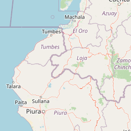
Map view of El Cajas National Park

Use this park location map to pinpoint El Cajas National Park in Ecuador, understand its exact geographic position, and read its mapped placement within the surrounding landscape more clearly.

Pigeon | © OpenStreetMap contributors
Park atlas

Compare surrounding protected areas, exploring other Andean páramo ecosystems, glacial features, and wetland landscapes near El Cajas National Park.

Discover National Parks and Protected Areas Near El Cajas, Mapping Andean Highlands Geography

After exploring El Cajas National Park, delve into a curated atlas of nearby protected areas and national parks, discovering contiguous páramo habitats, other glacial landscapes, and vital Andean wetland ecosystems. This geographic view helps trace regional conservation efforts and compare diverse protected-area characteristics, enhancing understanding of the wider mountain wilderness in Ecuador.
National parkAzuay
Mapped location lies within the park boundary#1 closest

Southeast

Parque nacional Cajas: Mapping the Glacial Lakes and Paramo of the Ecuadorian Andes

Geographic analysis of high-elevation protected lands

Parque nacional Cajas encompasses a rugged, glacial-sculpted plateau characterized by cushion vegetation, boggy wetlands, and frequent fog. This protected area offers deep insight into the highland Andean geography of Azuay, where water bodies and mountain ridges intersect to form an essential ecological and cultural corridor for the region.

Area
293.89 km²
Established
1977
IUCN
II
Visitors
53K annual
Watercolor illustration showing a mountain landscape with a snow-capped peak, a lake, and green hills.
National parkEcuador
About 52 km away#2 closest

Northeast

Sangay National Park: Ecuador's National Park for Mapped Landscape and Geographic Discovery

Explore Ecuador's protected area boundaries and regional terrain.

Sangay National Park serves as a crucial protected landscape within Ecuador, offering rich opportunities for atlas and geography exploration. This page details the park's specific mapped boundaries and its natural terrain, providing essential context for understanding its place within South America's broader geographic tapestry. Investigate Sangay National Park's identity as a protected national park and its value for focused landscape and regional discovery.

Area
5,177.65 km²
Established
1979
IUCN
II
Nature reserveGuayas Province
About 57 km away#3 closest

Northwest

Reserva ecológica Manglares Churute: Mapping a Coastal Nature Reserve in Guayas Province

An ecological mosaic of mangrove forests, estuaries, and forested ridges.

Spanning from the inner Gulf of Guayaquil into the Churute hill range, Reserva ecológica Manglares Churute acts as an essential protected area within Ecuador. The region contains one of the country's most significant mangrove complexes, complemented by freshwater lagoons and unique fog-affected forest summits that support diverse wildlife populations and endemic vegetation.

Area
471.74 km²
Established
1979
IUCN
Ia
Relief
Mixed relief
National parkEcuador
About 67 km away#4 closest

East

Parque nacional Río Negro-Sopladora: Andean Protected Area and Highland Connectivity Atlas

Mapping forest-to-páramo transitions in the Eastern Cordillera

Parque nacional Río Negro-Sopladora encompasses a vast, undisturbed stretch of the southern Eastern Cordillera of the Andes. This protected landscape is defined by its dramatic vertical relief, which funnels water into the Río Negro and Sopladora basins while supporting a diverse array of endemic plants and high-altitude species. Gain insight into its role as a key geographic link in the Cóndor Kutukú-Palanda connectivity network through this structured park map.

Area
306.163 km²
Established
2018
IUCN
II
Relief
Mountain
Wildlife reserveGuayas
About 102 km away#5 closest

West

Refugio de Vida Silvestre Manglares El Morro: Protected Coastal Landscape and Map

A strategic marine and mangrove ecosystem in the Guayas Province

The landscape of Refugio de Vida Silvestre Manglares El Morro consists of continuous mangrove forests and rocky farallones, linked by a complex network of tidal channels. This wildlife refuge serves as an essential marine habitat at the threshold of the Gulf of Guayaquil, showcasing the interplay between tidal aquatic systems and coastal vegetation across the southwestern Ecuadorian region.

Area
101.3 km²
Established
2007
IUCN
Ib
Visitors
23K annual
Wildlife reserveGuayas
About 104 km away#6 closest

Northwest

Reserva de producción de fauna Manglares El Salado: Coastal Geography and Protected Lands

A mangrove-dominated wildlife reserve in Guayas, Ecuador.

Analyze the protected landscape of Reserva de producción de fauna Manglares El Salado, which spans extensive mangrove forests and estuarine waters within the Guayas province. This wildlife reserve showcases a unique transition between intertidal mangrove zones, salt flats, and remnants of tropical dry forest, providing essential habitat context for the Gulf of Guayaquil coastal region.

Area
53.09 km²
Established
2002
IUCN
VI
Relief
Lowland
Nature reserveMorona Santiago
About 109 km away#7 closest

Southeast

Reserva biologica El Quimi: Protected Andean Watersheds and Cordillera del Condor Geography

A rugged nature reserve defined by complex metamorphic and volcanic mountain terrain.

Reserva biologica El Quimi guards the headwaters of the Quimi River along a strategically positioned watershed divide. Located in the province of Morona Santiago, this reserve features steep forested slopes and high plateau edges. Its varied geological foundation contributes to the broader regional ecological network, serving as a sanctuary for diverse mammal species including the Andean bear and jaguar.

Area
90.24 km²
Established
2006
Relief
Mountain
Climate
Subtropical
Nature reserveGuayas
About 113 km away#8 closest

Northwest

Bosque Protector La Prosperina Nature Reserve and Coastal Ecuador Forest Geography

Protected dry forest habitat and regional geographic terrain

Bosque Protector La Prosperina represents a critical survival of Ecuador's equatorial dry forest within the Guayas province. This nature reserve offers deep insight into seasonal ravine networks, drought-adapted vegetation, and the structural dynamics of fragmented coastal landscapes near Guayaquil.

Area
2.424 km²
Established
1994
Relief
Upland
Climate
Tropical

Common questions about visiting, size, designation, and location context for El Cajas National Park

El Cajas National Park FAQs for park facts, access, geography, and protected area context

Find quick answers about El Cajas National Park, including protected-area facts, park geography, trail and visitor context, and how the park fits into its surrounding country and regional landscape.
MoriAtlas Explorer

Continue Your Protected Areas Search Across the Global Atlas

Deepen your exploration by continuing the structured search for national parks and protected areas worldwide. Utilize the comprehensive filtering capabilities to compare different conservation landscapes and refine your understanding of global park geography. Discover more about the distribution and characteristics of protected natural areas.

Global natural geography