Mori Atlas logo
Nature reserveErlenwiesen bei Ober-Roden

Examining the ecological mosaic and riparian forest structure within this Hessen protected area

Erlenwiesen bei Ober-Roden: A Protected Nature Reserve in the Messeler Hügelland Region

(Naturschutzgebiet Erlenwiesen bei Ober-Roden)

Erlenwiesen bei Ober-Roden serves as a significant protected nature reserve within the Offenbach district of southern Hessen. Covering roughly 14 hectares, the area preserves a compact, layered sequence of floodplain forests, wet meadows, and sedge marshes characteristic of the Messeler Hügelland. This site provides a critical reference for understanding the natural mosaic of low-lying stream valley landscapes in Germany.

nature reservewet woodlandfloodplain forestwet meadowssedge marshesreedbeds

Erlenwiesen bei Ober-Roden

Nature reserve

Park overview

Structured park overview, official facts, and landscape profile for Erlenwiesen bei Ober-Roden

Erlenwiesen bei Ober-Roden park facts, protected area profile, and essential visitor context

Review the core facts for Erlenwiesen bei Ober-Roden, including designation, size, terrain, visitor scale, habitats, and operating context in one park-focused overview.

About Erlenwiesen bei Ober-Roden

Erlenwiesen bei Ober-Roden is a nature reserve in the German federal state of Hesse, situated southwest of the Ober-Roden district of Rödermark in the Offenbach district. The reserve is part of the broader landscape of the Messeler Hügelland, a natural region characterized by gently rolling terrain formed from the geological legacies of the southern Hesse lowlands. It occupies a modest footprint of about 14 hectares, but is recognized as a regionally important ecological node.

The protected area combines several distinct habitat types within a small geographic space. Oakdominated broadleaf woodland, including elements of the Hainsimsen-Buchenwald community typical of the region, shares the landscape with wet woodland dominated by black alder and ash growing along the banks of small watercourses. Around these wooded areas lie wet meadows, sedge-dominated marsh communities, reedbeds, and patches of older fallow land that together create a continuous ecological transition from aquatic edge to dry woodland.

The official purpose of the reserve is to preserve and develop these characteristic Messeler Hügelland habitats, including broadleaf forest, reed and large sedge plant communities, damp meadows, and stream-bank vegetation. By protecting a representative set of natural community types in such a compact area, the reserve contributes to the regional network of protected sites in the Offenbach district and supports the long-term survival of habitat types that have become scarce in surrounding agricultural and urban landscapes.

Quick facts and research context for Erlenwiesen bei Ober-Roden

Erlenwiesen bei Ober-Roden is a designated nature reserve (Naturschutzgebiet) in Hesse, Germany, located in the Ober-Roden area of the municipality of Rödermark within the Offenbach district. The reserve covers about 14.337 hectares and sits in the Messeler Hügelland, a rolling lowland region typical of southern Hesse.

It was legally designated on 9 July 1996 and is managed by the lower nature conservation authority of the Offenbach district. The site combines forest, meadow, and abandoned land, with a particular focus on protecting alder floodplain woodland, sedge marshes, and damp meadow communities associated with small streams in the area.

Protection and recognition

Examine documented protection records and official international database entries for Erlenwiesen bei Ober-Roden.

Erlenwiesen bei Ober-Roden Protection Status and Official Protected Area Records

Erlenwiesen bei Ober-Roden protection status details bring together documented designation records and international database tracking data. Official protected area information provides clear reference points for conservation framework analysis.

Protection details

WDPA ID
318367
Park context

Deeper park guide and search-rich context for Erlenwiesen bei Ober-Roden

Erlenwiesen bei Ober-Roden history, landscape, wildlife, and travel context

Explore Erlenwiesen bei Ober-Roden through its history, landscape character, ecosystems, wildlife, conservation priorities, cultural context, and seasonal travel timing in a structured park guide built for atlas discovery and search intent.

Why Erlenwiesen bei Ober-Roden stands out

Erlenwiesen bei Ober-Roden is best known for its compact representation of wet woodland and meadow habitats typical of the Messeler Hügelland. The reserve protects a mosaic of oak-beech forest, black alder and ash floodplain woodland, riparian shrubs, large sedge swamps, bulrush stands, and species-rich wet meadows such as Molinia and flood-meadow communities. Its other defining characteristic is its ecological compactness: within just over 14 hectares, it preserves a layered sequence of habitats along a small stream system, including brown sedge mires, tall herb and reed vegetation, and stream-bank woodland. This combination of habitat diversity and small size gives the site disproportionate conservation value within the regional network of protected areas.
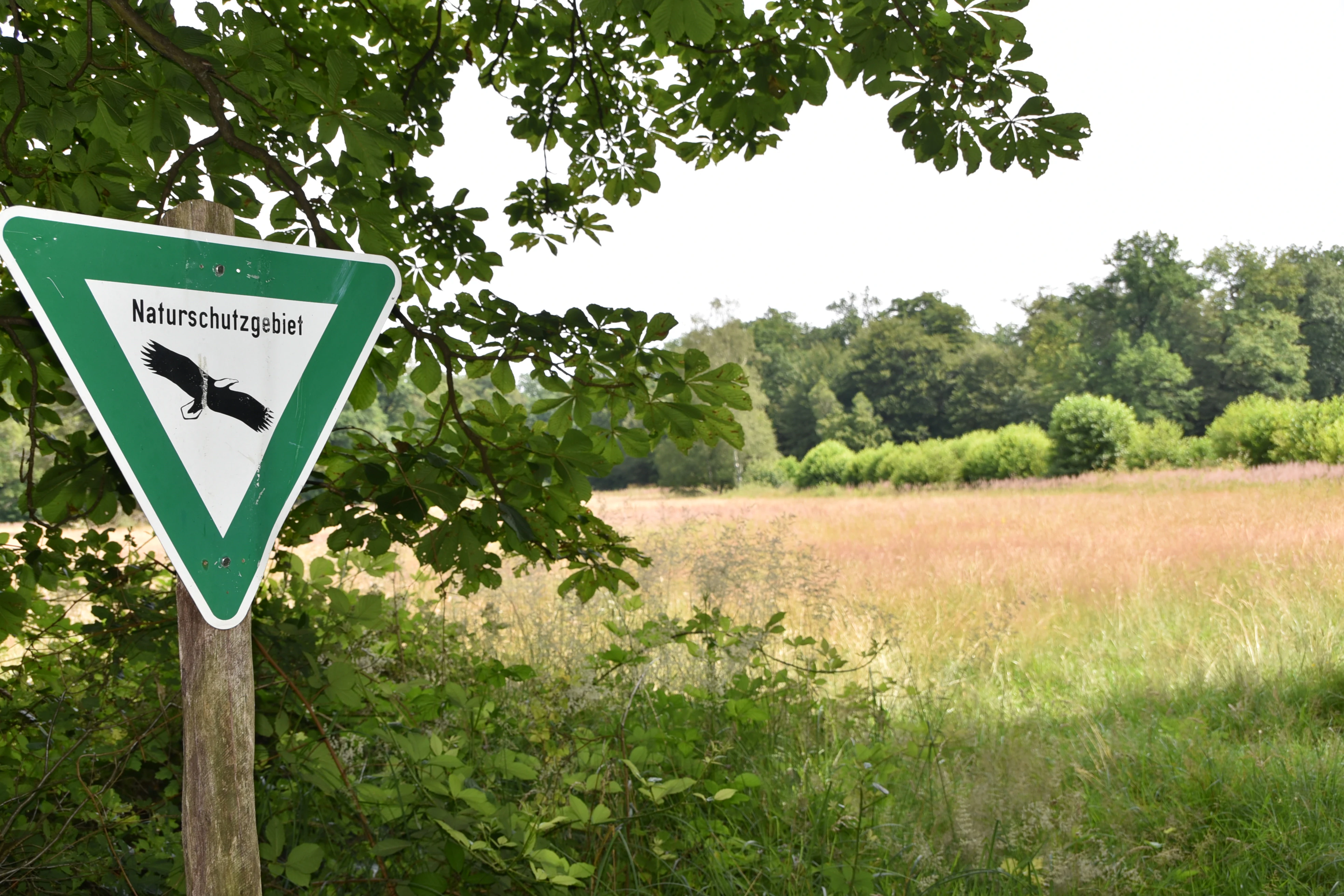
A triangular German Naturschutzgebiet (nature reserve) sign featuring an eagle icon, mounted on a wooden post in front of a meadow and forest edge.
A nature reserve sign marking the boundary of the Erlenwiesen bei Ober-Roden protected area.

Erlenwiesen bei Ober-Roden history and protected-area timeline

The Erlenwiesen bei Ober-Roden reserve has a relatively recent history of formal protection, but its ecological value had been documented well before designation. A botanical and zoological expert report prepared in 1993 by the planning office PLAN for the higher nature conservation authority at the Darmstadt regional presidency assessed the site as worthy of protection. The report, authored by P. Zanger and J. Neubecker, provided the scientific basis for the later designation.

On the basis of that assessment, the area was formally declared a Naturschutzgebiet on 9 July 1996 through an official ordinance. Since then, it has been managed by the lower nature conservation authority of the Offenbach district as a Category IV Habitat/Species Management Area within the international IUCN framework. The reserve is registered in the World Database on Protected Areas under the number 318367, reflecting its place within the global network of recognized protected sites.

Erlenwiesen bei Ober-Roden landscape and geographic character

Erlenwiesen bei Ober-Roden lies within the Messeler Hügelland, a gently rolling natural region in southern Hesse formed from the diverse geological substrata of the Rhine-Main lowlands. Elevations within the reserve range from about 140 meters to 155 meters above sea level, placing it firmly within the lowland elevation band typical of the surrounding countryside.

The terrain is dominated by a small valley system shaped by gentle streams, along which the protected habitats are arranged in a typical lowland mosaic. Slightly elevated, drier ground supports oak-rich broadleaf woodland, while the lower, flatter areas adjacent to the watercourses host wet meadows, sedge and reed communities. The transition between these zones is often marked by narrow bands of alder and ash floodplain forest and dense riparian shrub cover, giving the small reserve a layered and visually varied landscape structure despite its modest size.

Erlenwiesen bei Ober-Roden ecosystems, habitats, and plant life

The ecological character of Erlenwiesen bei Ober-Roden is defined by the close coexistence of broadleaf woodland and wetland habitats along a small drainage system. The reserve protects habitat types that are characteristic of, and increasingly restricted within, the Messeler Hügelland natural region.

Central to the site are oak-associated Hainsimsen beech forests on the better-drained slopes, black alder and ash floodplain woodlands along the stream corridors, and a varied wetland complex of large sedge mires, reedbeds, brown sedge swamps, Molinia (Pfeifengras) meadows, and flood-meadow communities. Together these habitats form a continuous ecological gradient from damp woodland edge to open wet meadow, providing niches for a range of plant and animal species typical of lowland Hessian wetlands and stream valleys.

By integrating forest, meadow, marsh, and riparian habitats in a single site, the reserve preserves an ecologically coherent unit that reflects the natural character of the broader Messeler Hügelland before extensive agricultural and urban transformation.

Erlenwiesen bei Ober-Roden conservation status and protection priorities

Erlenwiesen bei Ober-Roden is primarily valued for its role in preserving representative habitats of the Messeler Hügelland, a natural region that has experienced significant agricultural and suburban pressure over recent decades. The reserve focuses on the protection and long-term development of broadleaf forest communities, floodplain woodlands, and a complex of wetland habitats that include large sedge stands, reedbeds, brown sedge swamps, and species-rich wet meadows.

Under IUCN Category IV, the site is managed as a Habitat/Species Management Area, meaning that interventions are aimed not at strict wilderness preservation but at maintaining and enhancing particular habitat types and the species associated with them. Within the Offenbach district's protected-area network, Erlenwiesen bei Ober-Roden contributes a disproportionately important share of wet woodland and meadow habitat because it concentrates so many of these community types within a small footprint. The site is part of the listing of nature reserves of the Offenbach district and is included in the World Database on Protected Areas under the identifier 318367.

Top sights and standout views in Erlenwiesen bei Ober-Roden

A standout feature of Erlenwiesen bei Ober-Roden is the unusual habitat density packed into a small area: oak-rich broadleaf woodland on the slopes, black alder and ash floodplain forest along the streams, and a layered wetland mosaic of reedbeds, large sedge mires, brown sedge swamps, Molinia meadows, and flood-meadow communities.

Equally notable is the reserve's place within the protected-area network of the Offenbach district, where it complements other small nature reserves focused on wetland and woodland conservation. Its recognition in the World Database on Protected Areas and its IUCN Category IV status confirm its standing as a formally recognized Habitat/Species Management Area, while its 1993 expert assessment and 1996 designation document a deliberate effort to preserve what remains of the natural Messeler Hügelland landscape.

Best time to visit Erlenwiesen bei Ober-Roden

The reserve is most ecologically expressive in late spring and early summer, when wet meadows, reedbeds, and floodplain vegetation reach their full growth and woodland understories are at their most visible. Late spring also typically brings the most flow in small streams and the strongest display of meadow and sedge communities. In autumn, the broadleaf woodland component shows more subdued color, and the wet habitats recede, making it a quieter time for observation. Winter offers a sparser scene, with bare deciduous woodland along the streams and reduced herbaceous cover across the meadows.


Monthly climate preview

Long-term temperature and precipitation averages for representative coordinates

Erlenwiesen bei Ober-Roden Climate Normals and Monthly Weather Patterns

Historical climate records from 1991 to 2020 document the measured annual temperature progression and monthly precipitation rates across Erlenwiesen bei Ober-Roden. Detailed monthly climate normals provide structured context for examining the long-term meteorological profile of this protected landscape.
Annual mean10 °C
0 °C21 °C
Jan
Feb
Mar
Apr10°
May14°
Jun18°
Jul21°
Aug20°
Sep15°
Oct10°
Nov
Dec
Warmest month
July

20.6 °C

Coolest month
January

0.2 °C

Wettest month
July

2.2 mm/day

Driest month
April

1.4 mm/day

Park location guide

Geography guide, regional context, and park location map for Erlenwiesen bei Ober-Roden

Erlenwiesen bei Ober-Roden park geography, regions, and map view in Germany

Understand where Erlenwiesen bei Ober-Roden sits in Germany through a broader geographic reading of the surrounding landscape, nearby location context, and its mapped position within the national park landscape.

How Erlenwiesen bei Ober-Roden fits into Germany

Germany is a federal republic in Western and Central Europe with a population of over 83 million across sixteen constituent states. It is Europe's largest economy by nominal GDP and a major global exporter and importer. The capital is Berlin, and the country borders Denmark, Poland, Czech Republic, Austria, Switzerland, France, Luxembourg, Belgium, and the Netherlands.

Wider geography shaping Erlenwiesen bei Ober-Roden in Germany

Germany is located in Western and Central Europe, spanning 357,022 km². It borders Denmark to the north, Poland and the Czech Republic to the east, Austria and Switzerland to the south, and France, Luxembourg, Belgium, and the Netherlands to the west. The country has coastlines on the Baltic Sea and North Sea to the north, with the Alps located in the southern region.

Map view of Erlenwiesen bei Ober-Roden

Use this park location map to pinpoint Erlenwiesen bei Ober-Roden in Germany, understand its exact geographic position, and read its mapped placement within the surrounding landscape more clearly.

Pigeon | © OpenStreetMap contributors

Location context for Erlenwiesen bei Ober-Roden

Hessen

Visual reference collection showcasing wet woodland habitats and valley terrain

Erlenwiesen bei Ober-Roden Photos and Protected Area Landscape Views

Photographic records capture the mosaic of floodplain forests, sedge marshes, and wet meadows defining the protected landscape. Visual exploration reveals the compact terrain and habitat structure characterizing the nature reserve within the regional valley system.

A triangular German Naturschutzgebiet (nature reserve) sign featuring an eagle icon, mounted on a wooden post in front of a meadow and forest edge.

Park atlas

Compare surrounding lowland habitats and connected nature reserves across southern Hesse.

Other Parks Near Erlenwiesen bei Ober-Roden and Regional Protected Areas

Visitors exploring Erlenwiesen bei Ober-Roden can continue comparing nearby protected areas and lowland woodland reserves. Evaluating adjacent valley ecosystems provides broader context for regional conservation networks and habitat distribution.
A soft watercolor illustration depicting a calm wetland scene with distant rolling hills, foreground reeds, and overhanging tree branches.
Nature reserveHesse
About 0.9 km away#1 closest

East

Rallenteich von Eppertshausen Nature Reserve: Protected Landscape and Regional Geography

Wetland and forest mosaic in the Hesse region

Examine the geographic footprint of Rallenteich von Eppertshausen, a significant nature reserve in Hesse, Germany. This 12-hectare protected area showcases a dense mosaic of pond, reedbed, and acidic oak forest that evolved from historical clay mining. Understanding the park's topography and internal landscape zones offers insight into the evolution of post-industrial protected lands.

Area
0.12 km²
Established
1976
IUCN
IV
Relief
Lowland
A horizontal watercolor illustration depicting a soft, pastel-colored meadow with wildflowers in the foreground and a gentle forest line in the background against a white background.
Nature reserveLandkreis Darmstadt-Dieburg
About 1.8 km away#2 closest

Southwest

Neuwiese von Messel Nature Reserve: Mapped Geography and Protected Landscape Context

Essential nature reserve located in Landkreis Darmstadt-Dieburg

Neuwiese von Messel consists of open meadow islands surrounded by mature deciduous forest, creating a representative forest-meadow mosaic in the Messeler Hügelland. This nature reserve functions as a vital conservation site for specialized plants and habitat types, protected within the European Natura 2000 network. Gain insight into its terrain, soil-based biodiversity, and the centuries-old traditional management that sustains this protected German landscape.

Area
1.072 km²
Established
1986
IUCN
IV
Relief
Lowland
A soft watercolor painting of a winding stream through a green wetland with trees and distant hills in the background.
Nature reserveHessen
About 2.7 km away#3 closest

Southeast

Faulbruch von Münster Nature Reserve: Hessen Wetland and Forest Geography

Mapped protected landscapes in southern Germany.

Discover the geographic composition of Faulbruch von Münster, a protected nature reserve in Hessen. This area features a distinctive mix of alder swamp forest and wet meadows, providing a valuable habitat within the Rhine-Main region. Analyze the terrain, forest patches, and wetland boundaries through our detailed regional atlas.

Area
0.77 km²
Established
1985
IUCN
IV
Watercolor painting of a soft, hazy landscape featuring scattered trees, bushes, and rolling hills in shades of green and pink against a pale background.
Nature reserveHesse
About 3.7 km away#4 closest

South

Fohlenweide von Dieburg: Nature Reserve and Protected Landscape in Hesse, Germany

Mapping the wet meadow habitats and ecological boundaries of southern Hesse.

Located in the Darmstadt-Dieburg district, Fohlenweide von Dieburg is a refined example of a small-scale cultural landscape preserved for its high ecological value. The protected area features a unique mosaic of damp grasslands, forest margins, and riparian strips that support a range of wildlife. This site offers insight into regional conservation management in Central Europe.

Area
0.235 km²
Established
1989
IUCN
IV
Relief
Lowland
A watercolor painting of a flat, marshy landscape with soft green trees, grassy plains, and subtle pink tones against a white background.
Nature reserveHessen
About 4.5 km away#5 closest

Northeast

Rodauwiesen bei Rollwald Nature Reserve: Protected Lowland Landscapes in Hessen

Mapping floodplain meadows and reed habitats in the Rodau valley

The Rodauwiesen bei Rollwald nature reserve protects a distinct 32-hectare stretch of lowland floodplain along the Rodau stream in Hessen. This site serves as a vital green refuge, featuring expansive open grassland and significant common reed stands that mirror the historic character of the Untermainebene. Use this geographic reference to study the area's protected boundaries, hydrological terrain, and surviving wet meadow ecosystems within a rapidly developing urban corridor.

Area
0.327 km²
Established
1999
IUCN
IV
Relief
Lowland
Nature reserveLandkreis Offenbach
About 5 km away#6 closest

Northeast

Niederrodener Lache: A Protected Nature Reserve in Landkreis Offenbach, Germany

Brook-side habitat mosaic and regional landscape geography

Niederrodener Lache encompasses 124 hectares of protected woodland and grassland in the Landkreis Offenbach district. Centered on the Lache brook, the reserve hosts a dense interweaving of alder-fringed streams and varied meadow types. Its landscape profile provides a vital refuge for threatened vegetation and wetland biotopes within the suburbanizing Rhine-Main metropolitan area.

Area
1.246 km²
Established
1986
IUCN
IV
A horizontal watercolor painting depicting a soft-focus landscape with rolling green hills, a marshy foreground with grasses, and light purple mountains in the distance.
Nature reserveHesse
About 5.1 km away#7 closest

South

Das große Hörmes bei Dieburg Nature Reserve: A Wetland Protected Area in Hesse

Mapped lowland wetland habitat in the Gersprenz district

This compact nature reserve in southern Hesse provides a essential sanctuary for wetland species, featuring a rare combination of reedbeds, sedge stands, and moist litter meadows. The area highlights the historical character of the Gersprenz lowlands through its protected hydrological network and open herbaceous habitat structure.

Area
0.136 km²
Established
1985
IUCN
IV
A soft watercolor illustration depicting a meadow landscape with a winding stream, distant hills, and foreground wildflowers.
Nature reserveHessen
About 5.7 km away#8 closest

Southeast

Die kleine Qualle von Hergershausen Nature Reserve and Protected Floodplain Landscapes

A preserved wetland fragment in the Hessen region

Die kleine Qualle von Hergershausen stands as a key protected area within the Gersprenz floodplain. This site offers a unique look at remnant wet meadow terrain, serving as an essential breeding and stopover ground for waterbirds in the Darmstadt-Dieburg district. Its geography provides a clear contrast to the surrounding agricultural fields, highlighting the impact of long-term conservation and habitat restoration efforts.

Area
0.27 km²
Established
1984
IUCN
IV

Common questions about visiting, size, designation, and location context for Erlenwiesen bei Ober-Roden

Erlenwiesen bei Ober-Roden FAQs for park facts, access, geography, and protected area context

Find quick answers about Erlenwiesen bei Ober-Roden, including protected-area facts, park geography, trail and visitor context, and how the park fits into its surrounding country and regional landscape.
MoriAtlas Explorer

Continue Your Protected Areas Search Across the Global Atlas

Deepen your exploration by continuing the structured search for national parks and protected areas worldwide. Utilize the comprehensive filtering capabilities to compare different conservation landscapes and refine your understanding of global park geography. Discover more about the distribution and characteristics of protected natural areas.

Global natural geography