
Mori Atlas logo
Nature reserveFFH-Gebiet Wennebeker Moor und Langwedel

A diverse Natura 2000 mosaic of lowland bogs, meandering streams, and heath communities in northern Germany.

FFH-Gebiet Wennebeker Moor und Langwedel: Protected Landscape and Geologic Terrain Analysis

FFH-Gebiet Wennebeker Moor und Langwedel represents a significant protected area within the Schleswig-Holsteinisches Hügelland, showcasing a post-glacial terrain defined by terminal moraines and sandy deposits. This site preserves an exceptional concentration of Annex I habitats, including transition mires, bog woodland, and acidophilous oak forest. The meandering Wennebek stream and its associated hydrological network provide a critical structural link within the broader regional landscape and its underlying Pleistocene glacial tunnel valleys.

Natura 2000FFH siteSchleswig-Holsteinwet heathdry heathbog woodland
A flat vector illustration showing a calm pond in the foreground with cattails; in the background are rolling green hills, a winding path, and pine trees under a pale sky.

FFH-Gebiet Wennebeker Moor und Langwedel

Nature reserve

Park overview

Structured park overview, official facts, and landscape profile for FFH-Gebiet Wennebeker Moor und Langwedel

FFH-Gebiet Wennebeker Moor und Langwedel park facts, protected area profile, and essential visitor context

Review the core facts for FFH-Gebiet Wennebeker Moor und Langwedel, including designation, size, terrain, visitor scale, habitats, and operating context in one park-focused overview.

About FFH-Gebiet Wennebeker Moor und Langwedel

FFH-Gebiet Wennebeker Moor und Langwedel represents a compact yet ecologically varied Natura 2000 site in the Hügelland of Schleswig-Holstein, where post-Weichselian moraines, lowland peat and acidic sandy substrates combine to produce an unusually wide range of Annex I habitat types within a small surface area. With eight clearly distinguishable habitat classes represented, it is counted among the most diverse FFH sites in the state, despite the broader Westensee landscape in which it sits being classified by the Federal Agency for Nature Conservation as one of only limited conservation significance.

The protected area stretches roughly 2.25 kilometres east to west, from where the Eisendorfer Graben enters the site in the west to the south edge of the Bundesautobahn 7 in the east. Elevation varies only modestly, from about 20 metres above sea level where the Wennebek leaves the site beneath the motorway to 30.7 metres on a geest ridge in the Langwedel forest area. The Wennebek, a meandering lowland stream, is one of the defining hydrological features of the site, accompanied by side tributaries such as the Klostergraben and the Eisendorfer Graben.

Land ownership is dominated by the Federal Republic of Germany, with more than a quarter of the area held by the Stiftung Naturschutz Schleswig-Holstein. The site is split into a western Teilgebiet Wenneker Moor of roughly 100 hectares, largely under nature conservation ownership and managed through extensive grazing, and an eastern Teilgebiet StOÜbPl Langwedel of about 130 hectares situated within a Bundeswehr training area and closed to the public. Within the Natura 2000 framework the area contributes directly to the EU goal of maintaining favourable conservation status for the listed habitat types and to the broader Westensee regional ecological network.

Quick facts and research context for FFH-Gebiet Wennebeker Moor und Langwedel

FFH-Gebiet Wennebeker Moor und Langwedel is a 230 hectare Natura 2000 site in Schleswig-Holstein, Germany, within the Kreis Rendsburg-Eckernförde. It carries the EU Natura 2000 site code DE-1825-302 and is administered under Section 32 of the Federal Nature Conservation Act together with the Schleswig-Holstein state nature conservation act.

Designation was proposed in 2004 by the state of Schleswig-Holstein, confirmed by the EU as a Site of Community Importance in November 2007, and nationally designated as a Special Area of Conservation in January 2010. The standard Natura 2000 data form was last updated in May 2019. The protected area lies within the Naturpark Westensee and overlaps with the 1988 Naturschutzgebiet Wennebeker Moor und Wennebekniederung.

Protection and recognition

Documented terrestrial protection history, designation records, and management scope

FFH-Gebiet Wennebeker Moor und Langwedel Protection Status and Recognition

Terrestrial protection status for FFH-Gebiet Wennebeker Moor und Langwedel includes a designated establishment year of 2010. Official records compile administrative boundaries and conservation history for thorough evaluation.

Protection details

Protection scope
Terrestrial
Designated year
2010
Transboundary protection
No
WDPA ID
555517934
Park context

Deeper park guide and search-rich context for FFH-Gebiet Wennebeker Moor und Langwedel

FFH-Gebiet Wennebeker Moor und Langwedel history, landscape, wildlife, and travel context

Explore FFH-Gebiet Wennebeker Moor und Langwedel through its history, landscape character, ecosystems, wildlife, conservation priorities, cultural context, and seasonal travel timing in a structured park guide built for atlas discovery and search intent.

Why FFH-Gebiet Wennebeker Moor und Langwedel stands out

The site is particularly known for the concentration of Annex I habitat types it preserves in a compact area, including wet and dry heath communities, transition mires and quaking bogs, Rhynchosporion peat bog hollows, species-rich Nardetus grasslands, damp tall herb fringes, and the priority habitat type of bog woodland. These habitats co-occur with dystrophic ponds and meandering stream reaches of the Wennebek within a post-glacial terrain of low terminal moraines. The eastern sub-area is also distinctive for combining FFH conservation obligations with a working military training ground operated by the German armed forces, a situation that has required special inter-ministerial cooperation between the federal defence administration and the state of Schleswig-Holstein.
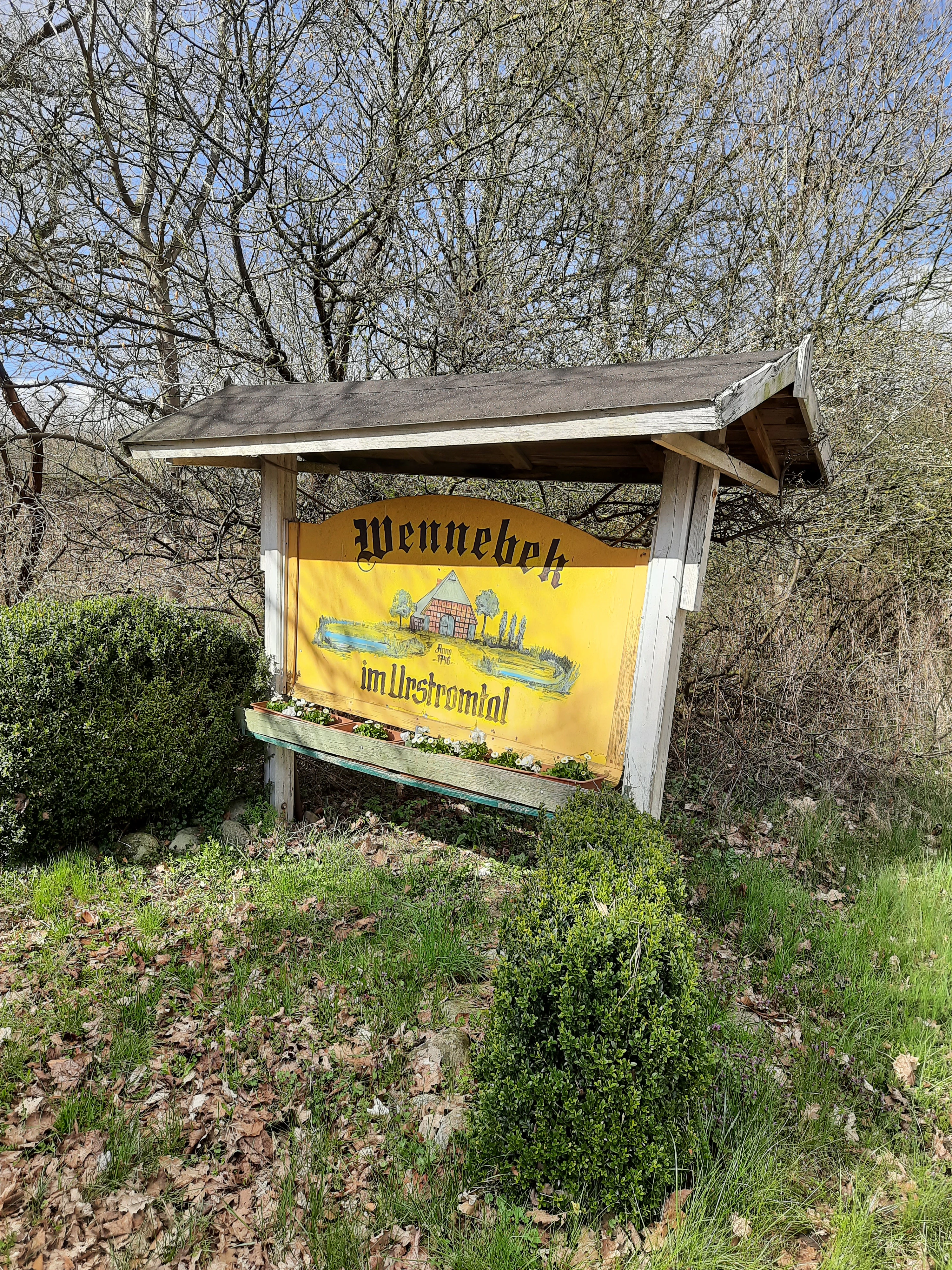
A weathered yellow information sign with a wooden roof stands in a field; it features an illustration of a traditional house and the text Wennebek im Urstromtal.
A wooden information sign marking the Wennebek valley area.

FFH-Gebiet Wennebeker Moor und Langwedel history and protected-area timeline

The conservation history of the site is rooted in the wider European Natura 2000 framework. An initial standard data form was completed in June 2004 by the Landesamt für Landwirtschaft, Umwelt und ländliche Räume of Schleswig-Holstein. The area was proposed as a Site of Community Importance in September 2004, confirmed at EU level in November 2007, and nationally designated as a Special Area of Conservation under Section 32 of the Federal Nature Conservation Act together with Section 23 of the Schleswig-Holstein state nature conservation act in January 2010. The data form was subsequently updated in May 2019.

The western sub-area has a longer national protection history, having been designated as the Naturschutzgebiet Wennebeker Moor und Wennebekniederung on 19 May 1988, predating the Natura 2000 designation by more than fifteen years. A management plan for the FFH sub-area Wennebeker Moor was published on 21 August 2017.

The eastern sub-area presented a more complex administrative situation because it sits within an active Bundeswehr training area. Because Natura 2000 administration is a state responsibility in Germany but the land is federally owned, an agreement was reached between the Federal Ministry of Defence and the state of Schleswig-Holstein to align the training ground function with Natura 2000 requirements. A joint set of planning documents was produced: a Naturschutzfachlicher Grundlagenteil for the military sub-area, equivalent to the standard FFH management plan, and a separate Maßnahmen-, Pflege- und Entwicklungsplan produced under federal procedure. Schleswig-Holstein also conducts FFH monitoring of the area on a six-year cycle.

FFH-Gebiet Wennebeker Moor und Langwedel landscape and geographic character

The protected area sits in a gently rolling stretch of the Schleswig-Holsteinisches Hügelland, formed by terminal moraines of the Weichselian glacial complex and underlain by sandy deposits that have favoured the development of lowland bogs. Elevation differences are small, between roughly 20 and 30.7 metres above sea level, but the subtle topography is enough to create a clear mosaic of dry geest ridges and wet, peaty depressions.

The central hydrological feature is the Wennebek, which enters the western sub-area at Springwedel and runs beneath the Bundesautobahn 7 at the eastern edge of the site. Where the stream is unconstrained by roads or settlement, it follows a natural, meandering course through lowland wet grassland. The Eisendorfer Graben in the northwest and the Klostergraben, joining as a right tributary after about 600 metres, feed the system together with several artificial ponds constructed as amphibian breeding sites.

Geologically, the area includes a notable tunnel-valley feature. The wet lowland corridor through the site belongs to the protected geotope known as the Fuhlenau / Mühlenau, Gut Westensee, Pohlsee, Brahmsee, Nortorf and Olendieksau tunnel valley, linking the site's modern ecological value with a clear Pleistocene glacial legacy. In the StOÜbPl Langwedel sub-area, the central landscape south of the motorway is dominated by a heather complex ranging from bog heath to dry heath, ringed by different forest biotope types with dry grassland fringes along the edges.
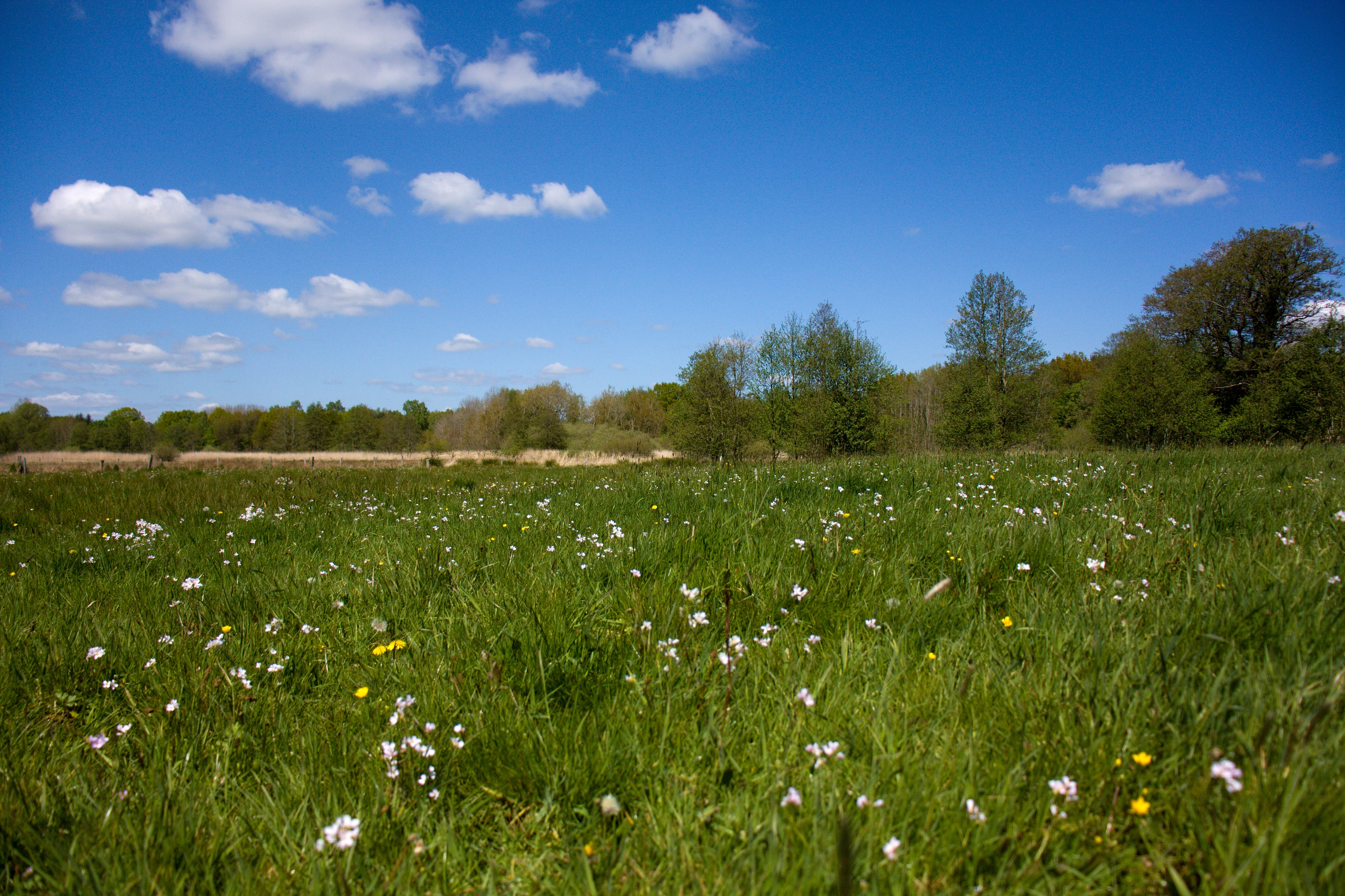
A wide, low-angle view of a green meadow filled with small white wildflowers under a bright blue sky with scattered clouds, with a tree line in the background.
A view across a flowering meadow in the Wennebeker Niederung nature reserve.

FFH-Gebiet Wennebeker Moor und Langwedel ecosystems, habitats, and plant life

Ecologically, the site is defined by the unusually broad range of Annex I habitat types compressed into 230 hectares. Priority habitat types of conservation importance include species-rich Nardetus grasslands (6230) and bog woodland (91D0). Other protected types present are nutrient-rich standing waters with pondweed or frogbit communities (3150), dystrophic standing waters (3160), flowing waters with floating aquatic vegetation (3260), wet heaths with cross-leaved heath (4010), dry heaths (4030), damp tall herb fringes (6430), transition mires and quaking bogs (7140), and Rhynchosporion peat bog hollows (7150), together with old acidophilous oak woodland on sand plains dominated by pedunculate oak (9190).

Together, only about 19 percent of the site area is covered by habitat types formally classified under the FFH directive, and dry heaths account for nearly half of that protected habitat area. The wider habitat mosaic nevertheless includes additional heath, mesic grassland, mire, swamp and riparian vegetation, conifer plantations, dry grassland, deciduous woodland, sandy open ground and standing and flowing waters, giving the site a particularly diverse habitat class composition within the state.

Hydrology is a central driver of ecological character. The Wennebek is dammed periodically during summer months to rewet sections of the lower lying land for the benefit of moor frog habitat, and a network of nine amphibian breeding ponds has been created along the Eisendorfer Graben and the southern reaches of the Wennebek. The Klostergraben and other slow-moving waters support dystrophic, nutrient-poor conditions that maintain several of the mire and bog habitat types.

FFH-Gebiet Wennebeker Moor und Langwedel wildlife and species highlights

The site does not have a separate species list in the source page, but wildlife interest is shaped by the wetland and heath mosaic. The hydrological management of the Wennebek and Klostergraben, including summer impoundment and the creation of nine ponds along the Eisendorfer Graben, is explicitly directed at amphibians such as the moor frog, indicating that the site is a meaningful local stronghold for amphibian fauna.

The Wennebek itself is recognised as an important fish watercourse in the broader EU Water Framework Directive context as part of the Bellerbek water body, although the loss of longitudinal connectivity through barriers such as weirs is the main obstacle to reaching a good ecological status. The combination of dystrophic ponds, transition mires, bog woodland and heath communities suggest a habitat matrix that would typically support wetland bird, dragonfly and other invertebrate communities typical of northwest German peatland and heath landscapes, even though individual species are not enumerated in the source material.

FFH-Gebiet Wennebeker Moor und Langwedel conservation status and protection priorities

The protected area has clear and well-documented conservation significance within the European Natura 2000 network, contributing to the maintenance of favourable conservation status for several Annex I habitat types, including the priority types 6230 species-rich Nardetus grasslands and 91D0 bog woodland. Its conservation importance lies partly in the unusually high habitat type diversity for its size in Schleswig-Holstein and partly in the hydrological system that maintains the mire and bog features across the two sub-areas.

Conservation management on the western sub-area is characterised by low-intensity year-round grazing with cattle and horses, particularly on the Stiftung Naturschutz Schleswig-Holstein lands west of Landesstraße 298. In the southern lowland area only horses are used for grazing, while the heath areas in this sub-area have been cleared of encroaching scrub. The open water management of the Klostergraben supports moor frog habitat. To prevent deterioration, grazing is to be maintained in the dry heath, oak woodland and transition mire areas in the northwest, with scheduled scrub clearance and mowing, and the western edge near the Eisendorfer Graben must be cleared and mown to maintain dry heath where grazing is not feasible. Bathing, diving and boating are prohibited on the Wennebek by nature conservation ordinance.

In the eastern sub-area, the 2009 baseline mapping was repeated in 2017 and showed an overall deterioration in the conservation status of nearly all habitat types, with nearly a quarter of FFH habitat area losing condition since 2009. This is most evident in dry heaths affected by ageing stands and progressive scrub encroachment, with some areas developing into woodland. The Maßnahmen-, Pflege- und Entwicklungsplan prepared by the federal military infrastructure office addresses these dynamics through a series of one-off and periodic management measures. The site is also part of the Naturpark Westensee and lies along the protected Fuhlenau and Mühlenau tunnel valley geotope, broadening its conservation framing beyond the Natura 2000 designation alone.

Top sights and standout views in FFH-Gebiet Wennebeker Moor und Langwedel

FFH-Gebiet Wennebeker Moor und Langwedel is notable for an unusually high concentration of Annex I habitats within a single Natura 2000 site, spanning wet and dry heaths, transition mires, bog woodland, dystrophic ponds and a meandering lowland stream. The site demonstrates how European nature conservation obligations can be integrated with unusual land uses, with the eastern sub-area doubling as a working Bundeswehr training ground under a formal federal-state agreement.

It also illustrates the layered nature of German protected-area governance, sitting within the Naturpark Westensee, encompassing the older 1988 Naturschutzgebiet Wennebeker Moor und Wennebekniederung, and aligning with the protected Fuhlenau and Mühlenau tunnel valley geotope, a Pleistocene geological feature that gives the modern mire landscape its underlying shape.

Monthly climate preview

Long-term temperature ranges and monthly precipitation data for Schleswig-Holstein protected terrain

FFH-Gebiet Wennebeker Moor und Langwedel Climate Normals and Annual Weather Patterns

Representative coordinate records show measured temperature variation from winter minimums below freezing to summer maximums near twenty-eight degrees, alongside consistent year-round precipitation. Examining the complete monthly climate profile reveals detailed thermal progression and multi-year meteorological averages across the protected landscape.
Annual mean9 °C
1 °C18 °C
Jan
Feb
Mar
Apr
May12°
Jun15°
Jul18°
Aug17°
Sep14°
Oct
Nov
Dec
Warmest month
July

17.7 °C

Coolest month
January

0.6 °C

Wettest month
July

2.5 mm/day

Driest month
April

1.4 mm/day

Park location guide

Geography guide, regional context, and park location map for FFH-Gebiet Wennebeker Moor und Langwedel

FFH-Gebiet Wennebeker Moor und Langwedel park geography, regions, and map view in Germany

Understand where FFH-Gebiet Wennebeker Moor und Langwedel sits in Germany through a broader geographic reading of the surrounding landscape, nearby location context, and its mapped position within the national park landscape.

How FFH-Gebiet Wennebeker Moor und Langwedel fits into Germany

Germany is a federal republic in Western and Central Europe with a population of over 83 million across sixteen constituent states. It is Europe's largest economy by nominal GDP and a major global exporter and importer. The capital is Berlin, and the country borders Denmark, Poland, Czech Republic, Austria, Switzerland, France, Luxembourg, Belgium, and the Netherlands.

Wider geography shaping FFH-Gebiet Wennebeker Moor und Langwedel in Germany

Germany is located in Western and Central Europe, spanning 357,022 km². It borders Denmark to the north, Poland and the Czech Republic to the east, Austria and Switzerland to the south, and France, Luxembourg, Belgium, and the Netherlands to the west. The country has coastlines on the Baltic Sea and North Sea to the north, with the Alps located in the southern region.

Map view of FFH-Gebiet Wennebeker Moor und Langwedel

Use this park location map to pinpoint FFH-Gebiet Wennebeker Moor und Langwedel in Germany, understand its exact geographic position, and read its mapped placement within the surrounding landscape more clearly.

Pigeon | © OpenStreetMap contributors

Location context for FFH-Gebiet Wennebeker Moor und Langwedel

Schleswig-Holstein

Visualizing post-glacial terminal moraines, lowland bogs, and protected heath habitats

FFH-Gebiet Wennebeker Moor und Langwedel Photos and Landscape Scenery

Visual documentation captures the complex mosaic of wet heath, transitional bogs, and meandering stream corridors across the protected terrain. Examining field photography reveals the subtle topography, bog woodland patches, and ecological character defining the natural landscape.

A weathered yellow information sign with a wooden roof stands in a field; it features an illustration of a traditional house and the text Wennebek im Urstromtal.

A calm, reflective pond surrounded by green trees, shrubs, and tall grasses under a clear blue sky.

A wide, low-angle view of a green meadow filled with small white wildflowers under a bright blue sky with scattered clouds, with a tree line in the background.

Park atlas

Discover adjacent protected landscapes and surrounding regional park geography.

Parks Near FFH-Gebiet Wennebeker Moor und Langwedel for Regional Comparison

Browsing other protected areas near FFH-Gebiet Wennebeker Moor und Langwedel reveals broader regional terrain patterns and wetland habitats. Comparing adjacent conservation sites helps place post glacial mire systems into a wider geographical context.
Nature reserveSchleswig-Holstein
About 10 km away#1 closest

West

Wälder der nördlichen Itzehoer Geest: Protected Area and Forest Landscape Atlas

Natura 2000 ancient woodland in Schleswig-Holstein

Explore the geography of Wälder der nördlichen Itzehoer Geest, featuring four historical forest tracts across glacial moraines. This protected area highlights Atlantic acid beech forests and floodplain habitats, preserving centuries-old woodland continuity within the broader Schleswig-Holstein landscape.

Area
7.11 km²
Established
2004
Relief
Upland
Climate
Temperate
A watercolor painting showing a soft panoramic view of green hills and a winding stream, with distant pale mountains in the background.
Nature reserveSchleswig-Holstein
About 13 km away#2 closest

Northwest

FFH-Gebiet Wehrau und Mühlenau Nature Reserve and River Corridor Geography

Protected riparian habitat in Schleswig-Holstein

Spanning over 246 hectares, this nature reserve protects a vital sequence of lowland streams, including the Mühlenau and Wehrau rivers. The area serves as an important refuge for rare mollusk species and aquatic wildlife, while preserving the integrity of a glacial tunnel valley geotope. This structured map view highlights the connectivity of wetlands, forests, and stream habitats that define the local landscape.

Area
2.46 km²
Established
2004
Relief
Lowland
Climate
Temperate
Nature reserveSchleswig-Holstein
About 15 km away#3 closest

Northeast

Wald nordwestlich Boksee Nature Reserve: Geographic Atlas and Protected Landscape Mapping

Ancient deciduous woodland within the Schleswig-Holstein moraine region

Wald nordwestlich Boksee stands as a protected nature reserve representative of Central European beech and oak ecosystems. Situated in the Plön district of Schleswig-Holstein, the site offers a detailed look at glacial moraine landscapes, historic boundary embankments, and the ecological management of ancient woodland habitats. This overview provides mapping context and structural insights into the forest's role within the local biodiversity corridor.

Area
0.25 km²
Established
2004
Relief
Upland
Climate
Temperate
A watercolor painting showing a flat, marshy shoreline leading to a calm lake, with rolling hills in the background and soft, muted tones of green and yellow.
Protected areaSchleswig-Holstein
About 24 km away#4 closest

Northwest

FFH-Gebiet Wittensee und Flächen angrenzender Niederungen Protected Area Geography

Glacial lake and lowland landscape context in Schleswig-Holstein.

Explore the physical geography of the FFH-Gebiet Wittensee und Flächen angrenzender Niederungen, encompassing the Wittensee glacial basin and its neighboring wetland corridors. This record provides a detailed look at the site's habitat mosaic, including calcareous fens and riparian woodlands situated along the Habyer Au and Schirnauer Au streams.

Area
12.2 km²
Established
2004
Relief
Lowland
Climate
Temperate
Nature reserveSchleswig-Holstein
About 27 km away#5 closest

Northwest

Wald östlich Hohn Nature Reserve: Ancient Broadleaf Forest Geography and Mapped Boundaries

Protected glacial moraine woodland in Schleswig-Holstein

Spanning roughly twelve hectares near Hohn, this nature reserve safeguards centuries-old broadleaf forest communities including beech and oak-hornbeam stands. The site is a significant protected area within the Schleswig-Holstein Geest, illustrating how ancient wooded islands persist amid intensive modern agricultural landscapes through formal Natura 2000 conservation status.

Area
0.118 km²
Established
2004
Relief
Lowland
Climate
Temperate
Nature reserveSchleswig-Holstein
About 31 km away#6 closest

Southeast

Tarbeker Moor Nature Reserve and Glacial Peatland Basin Geography

A restored wetland landscape in Schleswig-Holstein, Germany

Tarbeker Moor functions as a crucial nature reserve that showcases the successful rewetting of a former industrial peatland. Located in a shallow glacial meltwater channel north of Bad Segeberg, the park offers a distinct study in landscape recovery, featuring a dense mosaic of open water, floating vegetation, and diverse amphibian habitats.

Area
1.31 km²
Established
2004
A horizontal watercolor painting depicting a soft, rolling landscape with green trees in the foreground, a light-colored meadow or field in the midground, and distant muted hills in the background.
Protected areaSchleswig-Holstein
About 31 km away#7 closest

Northwest

FFH-Gebiet Wälder der Hüttener Berge: Protected Area and Glacial Moraine Atlas

Ancient beech woodland mosaics in Schleswig-Holstein.

FFH-Gebiet Wälder der Hüttener Berge comprises eleven distinct state forest parcels stretching across northern Germany. This atlas entry details the site's rich habitat structure, including rare Atlantic beech forests, transition mires, and glacial soils, providing essential geographic context for this vital Natura 2000 protected territory.

Area
4.16 km²
Established
2004
Relief
Upland
Climate
Temperate
Nature reserveSchleswig-Holstein
About 35 km away#8 closest

Northwest

FFH-Gebiet Übergangsmoor im Kropper Forst: Protected Landscape and Mire Geography

A study of transitional mire habitats in Schleswig-Holstein.

This protected area centers on a treeless mire depression embedded within the coniferous Gehege Kropp forest. Covering 18 hectares of glacial terrain, the site illustrates the delicate balance of mire hydrology and the long-term ecological impact of regional landscape management in northern Germany.

Area
0.18 km²
Established
2004
Relief
Lowland
Climate
Temperate

Common questions about visiting, size, designation, and location context for FFH-Gebiet Wennebeker Moor und Langwedel

FFH-Gebiet Wennebeker Moor und Langwedel FAQs for park facts, access, geography, and protected area context

Find quick answers about FFH-Gebiet Wennebeker Moor und Langwedel, including protected-area facts, park geography, trail and visitor context, and how the park fits into its surrounding country and regional landscape.
MoriAtlas Explorer

Continue Your Protected Areas Search Across the Global Atlas

Deepen your exploration by continuing the structured search for national parks and protected areas worldwide. Utilize the comprehensive filtering capabilities to compare different conservation landscapes and refine your understanding of global park geography. Discover more about the distribution and characteristics of protected natural areas.

Global natural geography