Mori Atlas logo
National parkFosse aux Lions National Park

Explore the mapped boundaries and regional landscape context of this key protected area.

Fosse aux Lions National Park: A Protected National Park within Savanes Region's Geography

(Parc National Fosse aux Lions)

Fosse aux Lions National Park stands as a designated national park within the Savanes Region of Togo, offering a specific focus for geographic exploration and protected-area discovery. This page provides detailed insight into its mapped boundaries and its role within the regional landscape, serving as a vital point for atlas-based understanding of Togo's conservation areas. Users can delve into the park's unique geographic identity and its place within the natural terrain of the Savanes Region.

national parksavanna ecosystemTogoWest Africaprotected areaGuinea savanna

Fosse aux Lions National Park

National park

Park overview

Structured park overview, official facts, and landscape profile for Fosse aux Lions National Park

Fosse aux Lions National Park park facts, protected area profile, and essential visitor context

Review the core facts for Fosse aux Lions National Park, including designation, size, terrain, visitor scale, habitats, and operating context in one park-focused overview.

About Fosse aux Lions National Park

Fosse aux Lions National Park occupies a distinctive position in Togo's protected area system as one of three national parks and one of the oldest conservation designations in the country. Located in the Savanes Region of northern Togo, the park encompasses approximately 16.5 square kilometers of Guinea savanna habitat, representing the drier, more open ecosystems that characterize much of northern Togo compared to the forest-dominated south. The park was first established as a reserved forest in 1954, making it one of the earliest protected areas in Togo, and it was subsequently designated as a national park to provide stronger conservation protection for its natural values. The Guinea savanna ecosystem within the park features a mix of grassy plains and scattered trees, adapted to the pronounced dry and wet seasons that define the regional climate. This landscape type supports a characteristic community of wildlife species adapted to open woodland and grassland habitats. The presence of the town of Tandjouaré within the park boundaries adds a human dimension to the protected area, reflecting the complex relationship between conservation and community livelihoods that characterizes many West African protected areas.

Quick facts and research context for Fosse aux Lions National Park

Fosse aux Lions National Park spans 16.5 square kilometers in northern Togo's Savanes Region, making it one of Togo's smaller protected areas. The park was originally established as a reserved forest in 1954, representing one of the earliest conservation designations in the country. Its location at approximately 10.75°N latitude places it in the Guinea savanna zone, a transition between the Sahel to the north and the forest zones of southern West Africa. The park contains the town of Tandjouaré within its boundaries, creating a unique human-environment relationship. The park was once notable for supporting significant populations of African elephants during the 1970s and 1980s, though populations have declined substantially.

Protection and recognition

Mapping the official terrestrial boundaries and conservation framework within the global database

Fosse aux Lions National Park Protection Status and Protected Area Designation

Natural-area explorers can analyze the terrestrial protection scope and official designation history established for Fosse aux Lions National Park. Structured geographic records provide essential context regarding conservation boundaries, environmental status, and global registry profiles.

Protection details

Protection scope
Terrestrial
Transboundary protection
No
Park context

Deeper park guide and search-rich context for Fosse aux Lions National Park

Fosse aux Lions National Park history, landscape, wildlife, and travel context

Explore Fosse aux Lions National Park through its history, landscape character, ecosystems, wildlife, conservation priorities, cultural context, and seasonal travel timing in a structured park guide built for atlas discovery and search intent.

Why Fosse aux Lions National Park stands out

Fosse aux Lions National Park is best known for its historical significance as an elephant habitat in West Africa, having supported substantial populations of African elephants during the latter half of the twentieth century. The park represents one of the northernmost significant protected savanna ecosystems in Togo, protecting a landscape type that is relatively rare in the country's protected area network. Its designation as a national park since the 1950s makes it one of Togo's longest-established conservation areas, providing decades of continuous protection for the Guinea savanna ecosystem. The park's location near Tandjouaré also makes it notable for containing an inhabited town within its boundaries, a characteristic that creates both management challenges and unique cultural landscape values.

Fosse aux Lions National Park history and protected-area timeline

Fosse aux Lions National Park traces its conservation history to 1954, when it was first established as a reserved forest under French colonial administration. This early designation reflected growing recognition of the need to protect West Africa's natural resources during the final years of colonial rule in French Togoland. The conversion to full national park status came as independent Togo sought to strengthen its protected area network and meet international conservation standards, adopting the IUCN Category II designation that provides enhanced legal protection for national park status. The park's establishment also coincided with broader continental efforts to preserve West Africa's diverse ecosystems and wildlife populations during a period when conservation awareness was expanding across newly independent African nations. Throughout the latter half of the twentieth century, the park maintained its conservation status through various management regimes as Togo developed its institutional capacity for protected area management.

Fosse aux Lions National Park landscape and geographic character

The landscape of Fosse aux Lions National Park exemplifies the Guinea savanna ecosystem that dominates much of northern Togo and extends across the wider West African savanna belt. The terrain consists of generally flat to gently undulating plains with scattered trees and shrubs, characteristic of the transition between the Sahel biome to the north and the forest zones of southern West Africa. The park's savanna landscape features a mixture of grasses that dominate during the wet season and become more sparse during the dry season, interspersed with deciduous trees that lose their leaves in response to seasonal drought. The region's climate features a pronounced rainy season from approximately May to October, followed by a dry season with lower humidity and minimal precipitation. This seasonal rhythm shapes the visual character of the landscape, with the park appearing lush and green during the wet months and more austere during the dry season.

Fosse aux Lions National Park ecosystems, habitats, and plant life

The Guinea savanna ecosystem protected within Fosse aux Lions National Park represents one of West Africa's most extensive habitat types, characterized by its mix of grasses and scattered trees. This ecosystem type supports a distinctive community of plant and animal species adapted to seasonal rainfall patterns and periodic fire regimes. The park's location in northern Togo positions it within a biogeographic zone where species from both more mesic forest environments and drier Sahel regions may overlap, creating ecological diversity within the savanna matrix. The vegetation community includes various grass species that dominate the ground layer, while tree species such as shea, baobab, and various acacias provide the scattered canopy that defines the savanna silhouette. This habitat structure supports diverse wildlife communities, though the specific species composition reflects the West African context rather than the more famous East African savanna ecosystems.

Fosse aux Lions National Park wildlife and species highlights

Fosse aux Lions National Park has historically been notable for its elephant populations, which were significant during the 1970s and 1980s but have declined substantially in more recent decades. This trend reflects broader patterns of elephant population decline across West Africa due to poaching, habitat loss, and human-wildlife conflict. The park's savanna habitat would have supported other characteristic West African wildlife species, including various antelope species, primates adapted to woodland environments, and diverse bird communities. While the current status of many species within the park would require current survey data to characterize precisely, the protected area provides important habitat connectivity for wildlife movements across the northern Togo landscape. The decline of elephant populations represents both a conservation challenge and a reminder of the pressures facing West African protected areas.

Fosse aux Lions National Park conservation status and protection priorities

Fosse aux Lions National Park represents an important conservation asset for Togo, providing protected status to a habitat type that is underrepresented in the country's protected area network. As one of the nation's three national parks, the area receives formal protection under IUCN Category II, which prohibits extractive uses and requires active management for conservation purposes. The park's establishment in 1954 means it has provided decades of continuous protection for its savanna ecosystem, making it one of the longest-running conservation experiments in the country. The Guinea savanna ecosystem that the park protects is ecologically significant as a transition zone between different West African biomes and supports species assemblages distinct from both the forest zones to the south and the Sahel to the north. However, the significant decline in elephant populations from historical highs demonstrates the ongoing challenges that West African protected areas face from poaching, habitat fragmentation, and human pressure.

Fosse aux Lions National Park cultural meaning and human context

Fosse aux Lions National Park contains within its boundaries the small town of Tandjouaré, creating a unique situation where an inhabited settlement exists within a national park. This characteristic reflects the complex history of protected area establishment in West Africa, where boundaries were often drawn without fully accounting for existing human settlements and land uses. The presence of the town within the park boundary creates both management considerations and potential opportunities for community-based conservation approaches. The broader Savanes Region of northern Togo is home to several ethnic communities whose traditional livelihoods include agriculture, pastoralism, and other land uses that interact with the savanna landscape. Understanding these human-environment relationships is essential for effective park management and for balancing conservation objectives with community well-being.

Top sights and standout views in Fosse aux Lions National Park

Fosse aux Lions National Park stands out as Togo's longest-established national park, providing over six decades of continuous protection for Guinea savanna ecosystems. The park's historical significance as an elephant habitat, even as populations have declined, highlights both the conservation value of the area and the challenges facing West African wildlife. The park protects a landscape type that is relatively uncommon within Togo's protected area network, representing the drier, more open environments of the country's north. The presence of Tandjouaré town within the park boundary offers a distinctive cultural landscape where traditional community life intersects with formal conservation designation.

Best time to visit Fosse aux Lions National Park

The best time to visit Fosse aux Lions National Park corresponds with the dry season from November through April, when weather conditions are more comfortable for outdoor exploration and wildlife viewing opportunities may be enhanced as animals concentrate around remaining water sources. The wet season from May to October transforms the landscape with lush vegetation but can make some areas less accessible and wildlife more dispersed. Visitors interested in experiencing the park's full ecological character should consider the seasonal variations in landscape appearance and wildlife accessibility that characterize savanna ecosystems across West Africa.

Monthly climate preview

Monthly temperature ranges and precipitation averages from representative coordinate data

Fosse aux Lions National Park Climate Normals and Temperature Patterns

Fosse aux Lions National Park experiences documented shifts in long-term average temperature and monthly precipitation across the representative coordinate dataset. Examining the complete twelve-month climate profile reveals detailed weather patterns across all recorded seasonal cycles.
Annual mean27 °C
24 °C31 °C
Jan24°
Feb28°
Mar31°
Apr31°
May29°
Jun28°
Jul26°
Aug26°
Sep26°
Oct26°
Nov26°
Dec24°
Warmest month
April

30.9 °C

Coolest month
December

24.1 °C

Wettest month
August

8.6 mm/day

Driest month
December

0 mm/day

Park location guide

Geography guide, regional context, and park location map for Fosse aux Lions National Park

Fosse aux Lions National Park park geography, regions, and map view in Togo

Understand where Fosse aux Lions National Park sits in Togo through a broader geographic reading of the surrounding landscape, nearby location context, and its mapped position within the national park landscape.

How Fosse aux Lions National Park fits into Togo

Togo, officially the Togolese Republic, is a narrow West African nation stretching from the Gulf of Guinea to Burkina Faso. It was colonized by Germany in 1884, transferred to France after World War I, and gained independence in 1960. The country has a population of approximately 9.6 million people across an area of about 56,785 km².

Wider geography shaping Fosse aux Lions National Park in Togo

Togo is located in West Africa, extending north from the Gulf of Guinea along a narrow coastal strip. It is bordered by Ghana to the west, Benin to the east, and Burkina Faso to the north. The country has a width of less than 115 km between Ghana and Benin. The terrain rises from a coastal plain to an interior plateau.

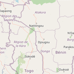
Map view of Fosse aux Lions National Park

Use this park location map to pinpoint Fosse aux Lions National Park in Togo, understand its exact geographic position, and read its mapped placement within the surrounding landscape more clearly.

Pigeon | © OpenStreetMap contributors

Location context for Fosse aux Lions National Park

Savanes Region
Park atlas

Map adjacent national parks and trace the protected savanna geography across Togo's northern region.

Discover Nearby National Parks and Protected Areas Around Fosse aux Lions National Park

Browse national parks and protected areas geographically connected to Fosse aux Lions National Park, exploring similar savanna ecosystems and conservation landscapes across Togo and West Africa. Deepen your atlas exploration by comparing diverse protected lands, tracing their regional distribution, and understanding their individual characteristics within the wider West African savanna belt.
Protected areaKompienga Province
About 67 km away#1 closest

Northeast

Lac de la Kompienga: Geography and Mapped Protected Landscapes in Kompienga Province

A landmark hydroelectric reservoir and wetland habitat

Lac de la Kompienga constitutes a primary water resource and ecological site within the dry savanna of Burkina Faso. This artificial reservoir creates a vital wetland mosaic, supporting diverse aquatic birdlife and fisheries while functioning as a critical component of the regional Volta Basin hydrology. The site captures the transition between engineered water management and the natural dry woodland ecosystems characteristic of the Est Region.

Area
175.45 km²
Established
1988
Relief
Lowland
Scope
Terrestrial
National parkKara Region
About 80 km away#2 closest

Southeast

Oti-Kéran National Park: Togo's Vast Protected Savanna Ecosystem and Regional Geography

Explore the mapped terrain and protected landscape of this key national park.

Delve into the geography of Oti-Kéran National Park, Togo's largest national park situated in the Kara Region. This protected savanna landscape, recognized as a Ramsar site, offers insights into its unique sudanian zone terrain, important bird habitats, and its function as a wildlife migration corridor. Understanding its mapped boundaries and ecological significance provides a core piece of the West African protected areas atlas.

Area
690 km²
Established
1950
IUCN
II
Relief
Lowland
National parkBenin
About 119 km away#3 closest

East

Pendjari National Park: Mapping Benin's Primary Protected Savanna Ecosystem and Wilderness

Located in northwestern Benin, bordering the WAP transboundary complex.

Pendjari National Park represents a significant conservation landscape in West Africa, featuring a complex geography of river-fed riparian forests, sprawling savanna plains, and the high-elevation cliffs of the Atakora mountain range. This protected area offers a look into an intact savanna wilderness, serving as a vital sanctuary for large mammals and diverse bird species within its clearly defined boundaries.

Area
2,755 km²
IUCN
II
Relief
Highland
Climate
Subtropical
National parkAtacora Department
About 119 km away#4 closest

East

Parc national de la Pendjari: Geographic Atlas and Protected Area Overview in Atacora Department

Savanna plains and quartzite mountain ridges in West Africa

Parc national de la Pendjari represents an ecologically vital protected landscape in the Atacora Department of Benin. This atlas overview details its complex geography, ranging from the flat sandstone peneplain to the permanent waters of the Pendjari River. Learn how these boundaries support one of the most significant contiguous savanna ecosystems in West Africa, featuring diverse habitats from gallery forests to open woodlands.

Area
4,700 km²
Established
1961
IUCN
II
Visitors
7K annual
Wildlife reserveBurkina Faso
About 127 km away#5 closest

Northwest

Lac de Bagré Wildlife Reserve: Mapping the Inland Reservoir of Central Burkina Faso

A critical wetland site within the Nakambé River valley.

Lac de Bagré acts as a major freshwater reservoir, stretching through the Boulgou and Zoundwéogo provinces of Burkina Faso. This artificial lake, created by the Bagré Dam, supports a unique ecological profile as a Ramsar-recognized wetland, offering a deep look into the intersection of hydrological infrastructure and protected Sahelian landscapes.

Area
367.93 km²
Established
1992
Water
Water-dominated
National parkTapoa Province
About 170 km away#6 closest

Northeast

Arli National Park National Park: Mapped Protected Landscape in Tapoa Province

Explore its geographic context and boundaries.

Arli National Park stands as a critical protected area, identified as a national park within Tapoa Province. This detail page serves as an atlas-focused entry point to understanding the park's unique landscape characteristics and its precise geographic location. Users can investigate its mapped boundaries and explore how it fits into the regional geography, offering a foundational understanding for protected-area discovery.

Area
760 km²
Established
1954
IUCN
IV
Relief
Upland
National parkSavannah Region
About 182 km away#7 closest

Southwest

Mole National Park: A Premier Protected Landscape in Ghana's Savannah Region

Explore mapped boundaries and Guinea savannah ecosystems.

Mole National Park represents a significant protected landscape within Ghana's Savannah Region, serving as the country's largest national park and a crucial conservation area for West African wildlife. The park's geography is defined by extensive Guinea savannah, characterized by grasslands with scattered woodlands and a prominent escarpment along its southern edge. Its vast expanse offers a unique opportunity to study mapped park boundaries and understand the ecosystem's role in regional conservation efforts. Discover the unique landscape context and protected area identity of this major West African wildlife refuge.

Area
4,840 km²
Established
1958
IUCN
II
Visitors
17.8K annual
Watercolor depiction of a river flowing through a landscape with green trees and distant mountains under a light sky
National parkBurkina Faso
About 189 km away#8 closest

Northwest

Kaboré Tambi National Park: Burkina Faso's Largest National Park and Protected Landscape

Explore the mapped savanna and birdwatching geography of this vital West African area.

Kaboré Tambi National Park represents a critical protected area in Burkina Faso, spanning a considerable expanse of Sudan-Guinea savanna. The park's geography is defined by the Nazinon River and a mosaic of woodland and grassland ecosystems, making it a significant site for understanding regional protected lands and landscape ecology. It offers a valuable point of reference for atlas-based exploration of West African natural areas.

Area
1,555 km²
Established
1976
IUCN
II
Relief
Lowland

Common questions about visiting, size, designation, and location context for Fosse aux Lions National Park

Fosse aux Lions National Park FAQs for park facts, access, geography, and protected area context

Find quick answers about Fosse aux Lions National Park, including protected-area facts, park geography, trail and visitor context, and how the park fits into its surrounding country and regional landscape.
MoriAtlas Explorer

Continue Your Protected Areas Search Across the Global Atlas

Deepen your exploration by continuing the structured search for national parks and protected areas worldwide. Utilize the comprehensive filtering capabilities to compare different conservation landscapes and refine your understanding of global park geography. Discover more about the distribution and characteristics of protected natural areas.

Global natural geography