
Mori Atlas logo
Nature reserveGeorgenfelder Hochmoor

Mapping the landscape context and conservation boundaries of this historic Ore Mountains peatland

Georgenfelder Hochmoor Nature Reserve: Geographic Analysis of a Ridge-Top Raised Bog Complex

(Naturschutzgebiet Georgenfelder Hochmoor)

Georgenfelder Hochmoor represents a rare highland raised bog situated on the high ridge plateau of the eastern Ore Mountains within the Sachsen region of Germany. This protected landscape preserves an unbroken ten-thousand-year ecological archive across its dome-shaped peat profile, acting as a critical watershed for regional headwater streams. Understanding the terrain and transboundary moorland restoration efforts provides essential insight into the geomorphology of this high-elevation protected area.

raised bogHochmoorOre MountainsOsterzgebirgeSaxonypeatland
A flat-style digital illustration of a serene landscape with a calm pool of water, coniferous and birch trees, fallen logs, and rolling mountain peaks under a soft, light-filled sky.

Georgenfelder Hochmoor

Nature reserve

Park overview

Structured park overview, official facts, and landscape profile for Georgenfelder Hochmoor

Georgenfelder Hochmoor park facts, protected area profile, and essential visitor context

Review the core facts for Georgenfelder Hochmoor, including designation, size, terrain, visitor scale, habitats, and operating context in one park-focused overview.

About Georgenfelder Hochmoor

Georgenfelder Hochmoor is a protected raised bog landscape in the eastern Ore Mountains of Saxony, Germany, sitting on the German-Czech border near Zinnwald-Georgenfeld. Covering around 13.5 hectares, it is the northwestern tip of a much larger moorland system that continues southward into the Czech Republic.

The bog developed in depressions on the Erzgebirgskamm after the Elsterian glaciation, when melting firn snow caps left small lakes without outflows. Over millennia, vegetation around these waters, including reeds, sedges, horsetails, and later sphagnum mosses, accumulated into layers of peat. Tree generations were repeatedly buried by new moss growth, producing alternating layers of older and younger forest peat. A long cool and wet phase later favored sphagnum that displaced trees entirely, building the raised, dome-shaped profile that gives the site its name.

Georgenfelder Hochmoor is one of the oldest nature reserves in Saxony, with formal protection dating back to 1926 through the initiative of the Landesverein Sächsischer Heimatschutz. The site was officially redesignated as a nature reserve in 1961. Historically, the bog played an important role in the regional water supply for tin mining near Altenberg but also suffered centuries of peat cutting and drainage. Since 2013 active rewetting measures have been undertaken to reverse past degradation, supported by parallel efforts on the Czech side of the border.

A roughly 1,200-meter boardwalk trail with bilingual German and Czech information panels guides visitors through the reserve, with a wooden viewing bridge and viewpoints across stillwater sections of the bog. The area belongs to a larger European Natura 2000 site and continues to function as a living archive of moorland ecology in the Ore Mountains.

Quick facts and research context for Georgenfelder Hochmoor

Georgenfelder Hochmoor is a Saxon nature reserve on the ridge of the Osterzgebirge, directly at the German-Czech border, near the town of Zinnwald-Georgenfeld. The protected area covers about 13.5 hectares and represents the German portion of a roughly 120-hectare transboundary moorland complex.

Established as a nature reserve in 1961, the bog originated after the Elsterian glaciation and is estimated to be around 10,000 years old, with peat layers reaching about five meters in thickness. It is one of the oldest nature reserves in Saxony and is classified as an IUCN Category IV Habitat/Species Management Area.

Protection and recognition

Documented terrestrial protection scope, management framework, and Natura 2000 records

Georgenfelder Hochmoor Protection Status and International Recognition Data

Georgenfelder Hochmoor maintains a documented terrestrial protection scope backed by official Natura 2000 recognition sources. Structured regulatory facts record international conservation designations without assuming management outcomes.

International recognition

Protection details

Protection scope
Terrestrial
Transboundary protection
No
WDPA ID
9363
Park context

Deeper park guide and search-rich context for Georgenfelder Hochmoor

Georgenfelder Hochmoor history, landscape, wildlife, and travel context

Explore Georgenfelder Hochmoor through its history, landscape character, ecosystems, wildlife, conservation priorities, cultural context, and seasonal travel timing in a structured park guide built for atlas discovery and search intent.

Why Georgenfelder Hochmoor stands out

Georgenfelder Hochmoor is best known for being one of the few ridge-top raised bogs of the eastern Ore Mountains and for its postglacial origin. Its roughly five-meter-thick peat profile preserves a roughly 10,000-year ecological archive, from cold-climate pioneer stages through drier birch and pine phases to the present-day moor pine landscape. The site is also recognized for its role in the regional water cycle. The bog absorbs large volumes of rainwater and snowmelt and releases it gradually, feeding headwater streams like the Warmbach. The combination of peat history, alpine-style moor pine vegetation, and transboundary conservation makes it a reference site for raised bog ecology in central Europe.

An informational sign on a wooden post in an open, shrubby landscape, titled Renaturierungsprojekt Georgenfelder Hochmoor, featuring project maps and descriptive text in German.
An informational sign detailing the restoration project at Georgenfelder Hochmoor.

Georgenfelder Hochmoor history and protected-area timeline

Georgenfelder Hochmoor was first brought under formal protection in 1926, when the Landesverein Sächsischer Heimatschutz purchased the land and had it declared a nature reserve. The botanist and teacher Georg Marschner was particularly influential in the acquisition and early study of the site, and the Dresden-based botanist A. Naumann conducted extensive research there in the early twentieth century.

The bog was officially redesignated as a protected area on 30 March 1961, making it one of the oldest nature reserves still in force in Saxony. Long before modern protection, however, the site had been shaped by human exploitation. From the sixteenth century onward, drainage channels such as the Neugraben were cut to divert bog water to the Großer Galgenteich reservoir in support of the booming tin mining industry around Altenberg, depriving the moor of water essential to its growth.

In the nineteenth and early twentieth centuries, the bog was also affected by commercial peat cutting, particularly before 1900 and again in the early 1920s. These activities converted parts of the moor into heathland. In the 1980s, additional damage came from forest dieback linked to air pollution from the North Bohemian lignite industry, which removed protective spruce moor forests and increased evaporation across the bog.

Since 2013, the site has been the focus of an active rewetting program, with around 120 ditch blockages, about 30 sheet piling barriers, and parallel measures on the Czech side, aimed at restoring the bog's natural water balance.

Georgenfelder Hochmoor landscape and geographic character

Georgenfelder Hochmoor occupies the flat, wind-exposed ridge of the Osterzgebirge at roughly 870 meters above sea level, making it a highland peatland rather than a lowland one. The name Hochmoor refers to the characteristic raised, dome-shaped profile of the bog itself, formed by continuous upward growth of sphagnum moss that dies off from below.

The moorland lies on a small, gently undulating plateau surrounded by subtle glacial and periglacial landforms left behind after the retreat of the Elsterian ice sheet. To the north rise the two distinctive rock outcrops of the Großer Lugstein and Kleiner Lugstein, separated by a prominent telecommunications tower built in the early 1990s. Several other bogs have also developed on these flattened parts of the Erzgebirgskamm, and together they mark important watershed divides in the ridge landscape.

The reserve contains a mosaic of stillwater pools, damp hummocks, drier heath-edged sections, and patches of bog woodland. A roughly 1,200-meter boardwalk, including a wooden viewing bridge, winds through this terrain, providing close access to the open dome of the bog without disturbing it.
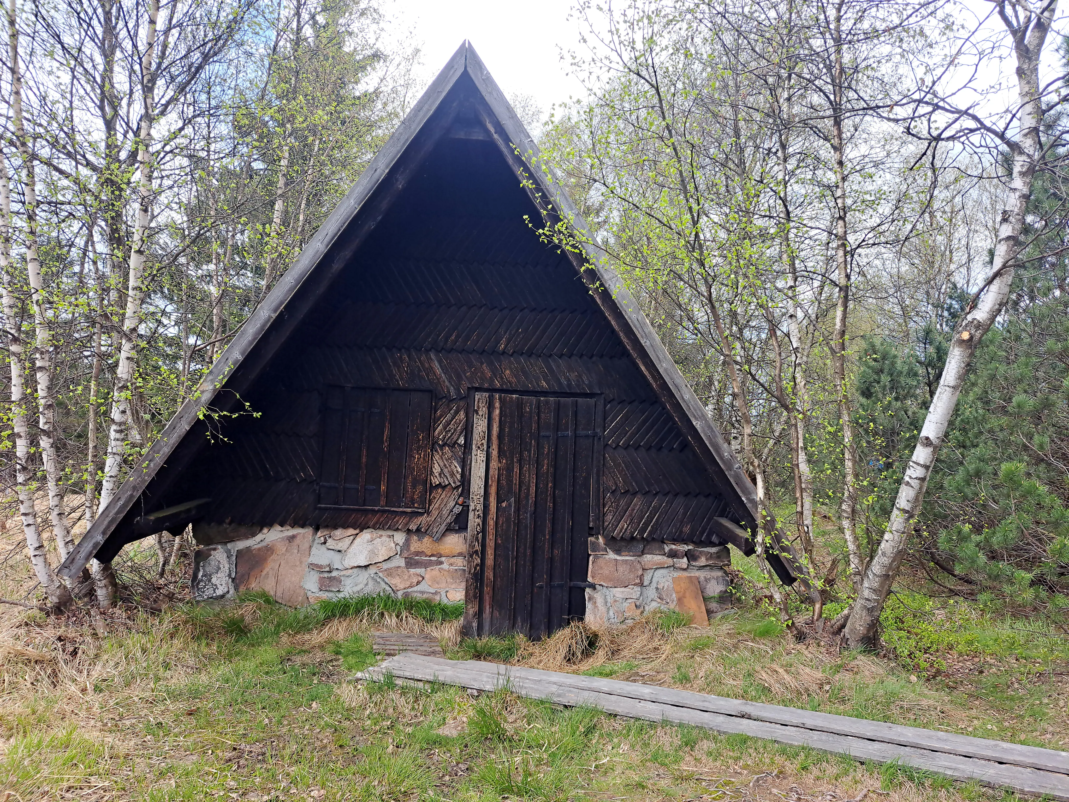
A small dark wooden cabin with an A-frame roof and a stone foundation, surrounded by birch trees and accessed by a wooden boardwalk.
A small wooden cabin along the boardwalk trail in Georgenfelder Hochmoor.

Georgenfelder Hochmoor ecosystems, habitats, and plant life

Ecologically, Georgenfelder Hochmoor is a classic raised bog complex with a clear ecological gradient from open bog to bog woodland and heath. The heart of the moor is dominated by sphagnum mosses, including species of the family Sphagnidae, which build the characteristic dome and retain large volumes of water. Moist areas are marked by cottongrass species, including scheidiges Wollgras and schmalblättriges Wollgras, while drier edges of the reserve have been colonized by heather and various berry species.

The bog pine, a low, often knee-high shrubby form of mountain pine adapted to harsh ridge climates, is the dominant woody plant across the reserve, accompanied by white birch, downy birch, and dwarf birch. The carnivorous round-leaved sundew (Rundblättriger Sonnentau) and peat-bog rhododendron (Sumpfporst) are among the more notable botanical highlights.

Parts of the reserve were historically degraded into heathland through peat cutting and drainage. Although some species such as bog berry and crowberry survive from the original northern tundra-like assemblage, past water-table lowering has altered the species mix. Current rewetting efforts aim to restore the hydrological conditions that favor the original raised bog community.

A beige informational sign with a black roof-like top piece mounted on a wooden post in front of dense pine trees. The sign has text in German and Czech about the Moorhuette.
An informational sign in the Georgenfelder Hochmoor describing the history of the Moorhuette: a shelter used by peat cutters.

Georgenfelder Hochmoor wildlife and species highlights

Georgenfelder Hochmoor is valued primarily as a botanical and hydrological site rather than a large-mammal reserve, yet its bog vegetation and stillwater pools support characteristic bog fauna. The mosaic of damp moss surfaces, open water, dwarf shrub heath, and bog woodland provides habitat for a range of invertebrates, amphibians, and bird species typical of central European raised bogs.

The reserve's status as a refuge for numerous threatened plant and animal species is one of the central reasons for its protection. Visitors typically encounter more botanical than wildlife highlights, but the surrounding ridge landscape, including nearby forest and heath, supports a wider range of mountain fauna typical of the Ore Mountains.
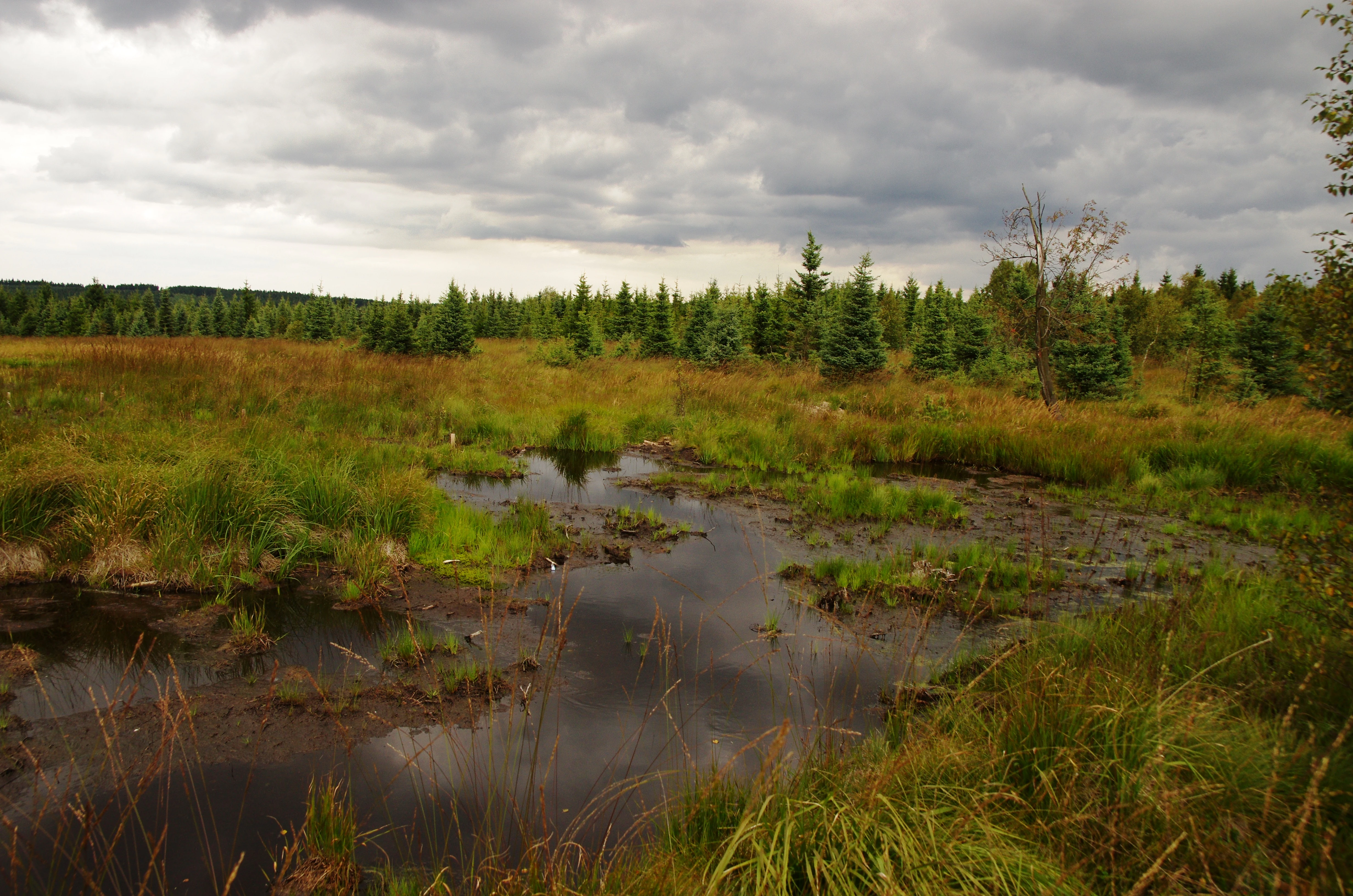
A landscape view of a peat bog with small pools of dark water, surrounded by marshy grasses and a line of evergreen coniferous trees under a cloudy sky.
A peat bog landscape in the Georgenfelder Hochmoor nature reserve.

Georgenfelder Hochmoor conservation status and protection priorities

Georgenfelder Hochmoor is one of the oldest nature reserves in Saxony and the only larger Kammhochmoor, or ridge-top raised bog, in the Osterzgebirge. Its conservation significance lies both in the unusualness of its habitat type at this elevation and in the integrity of its postglacial peat archive, which preserves climate and vegetation history spanning roughly 10,000 years.

The reserve has been repeatedly degraded over the centuries. Sixteenth-century drainage for the Altenberg tin mines reduced water supply, followed by commercial peat cutting in the nineteenth and early twentieth centuries and twentieth-century air pollution from North Bohemian industry, which killed surrounding spruce forests and accelerated evaporation.

Since 2013 a major restoration program has been underway, installing around 120 ditch blockages and approximately 30 sheet piling barriers to raise and stabilize water levels. The site is also part of the European Natura 2000 network through the FFH-Gebiet 174, and it is connected to protected moorland on the Czech side of the border, allowing cross-border conservation coordination.

Georgenfelder Hochmoor cultural meaning and human context

The moor has long been a landmark feature on the German-Czech border. The broader transboundary moor complex has traditionally been known by the name "Die See," reflecting its origins as a series of postglacial lakes. Drainage channels such as the Neugraben were constructed as early as the sixteenth century to harness bog water for the important tin mining industry around Altenberg.

A former peat cutter's hut on the site stands as a reminder of nineteenth- and early twentieth-century peat cutting, when the bog was exploited as a local source of fuel. Today the site also plays a small role in regional tourism and education, marked by bilingual German and Czech interpretation panels along its boardwalk, reflecting the shared cross-border stewardship of the moor.
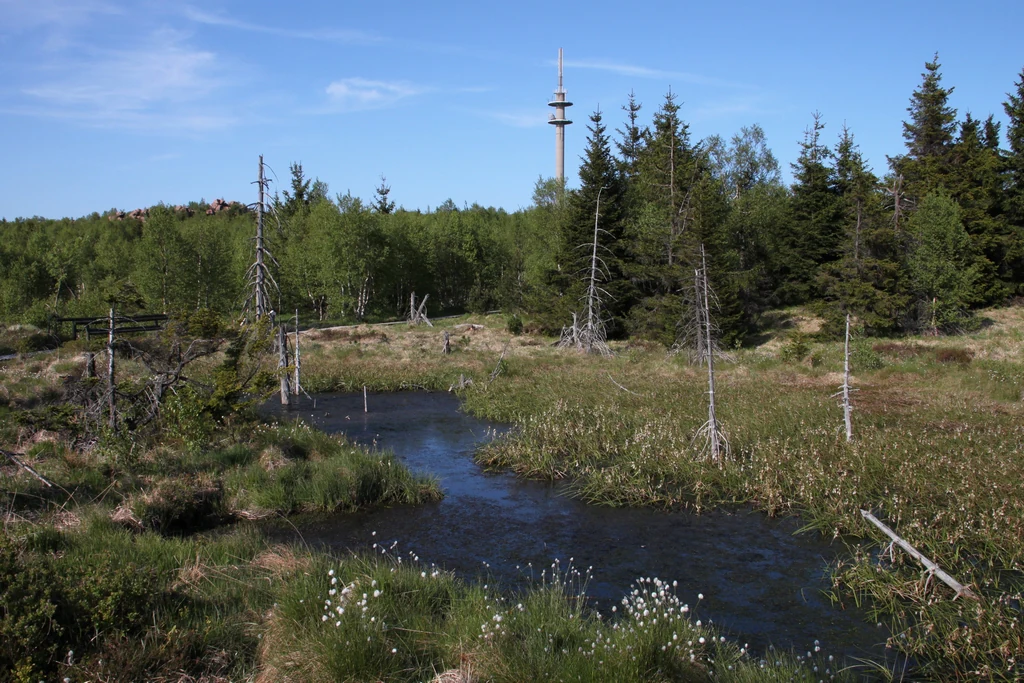
A peat bog landscape in Germany featuring a small dark pond in the foreground, surrounded by grassy wetlands and a forest edge with a tall telecommunications tower rising above the trees in the background.
A view of the Georgenfelder Hochmoor peat bog, characterized by wetlands, sparse trees, and the prominent Lugstein transmitter tower in the distance.

Top sights and standout views in Georgenfelder Hochmoor

Georgenfelder Hochmoor stands out for combining several distinctive qualities in a small area: a rare ridge-top raised bog in the Ore Mountains, an unbroken roughly 10,000-year peat record, and a long conservation history dating back to 1926. Its roughly 1,200-meter boardwalk with viewing bridge makes the dome of the bog unusually accessible for visitors without disturbing the fragile surface.

The reserve is also a model example of modern transboundary bog restoration. Ongoing rewetting on the German side is being carried out in coordination with parallel measures on the Czech side, aiming to reverse centuries of drainage, peat cutting, and pollution-driven drying of this sensitive ecosystem.
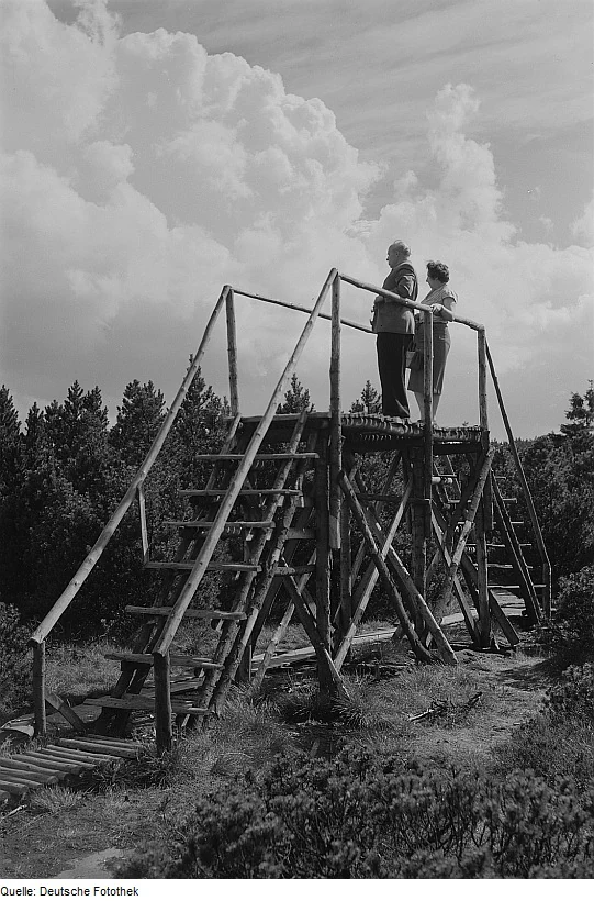
A black and white photograph showing a man and woman standing on a rustic wooden observation platform surrounded by a low-lying bog landscape and forest trees under a cloudy sky.
Visitors on an elevated wooden observation deck in the Georgenfelder Hochmoor peat bog.

Best time to visit Georgenfelder Hochmoor

The Georgenfelder Hochmoor reserve is typically open to visitors between May and October, when conditions for walking the boardwalk are most suitable. Late spring and early summer offer the freshest mossy greens, while late summer and early autumn highlight the berries, heather, and golden tones of the bog vegetation in the eastern Ore Mountains.

Winter visits are generally not practical for the bog path itself, but the surrounding ridge landscape around Zinnwald can be dramatic under snow, reflecting the same cold, wet climate that originally shaped the raised bog profile.

Monthly climate preview

Long-term monthly temperature and precipitation rhythm sampled at a representative coordinate in Sachsen

Georgenfelder Hochmoor Climate Normals and Measured Temperature Patterns

Representative coordinate measurements reveal the long-term annual temperature and precipitation rhythm across Georgenfelder Hochmoor from 1991 to 2020. Examining the complete twelve-month meteorological profile provides deeper insight into measured monthly normals and historical climate variations.
Annual mean8 °C
-3 °C19 °C
Jan-3°
Feb-1°
Mar
Apr
May13°
Jun17°
Jul19°
Aug18°
Sep13°
Oct
Nov
Dec-2°
Warmest month
July

18.7 °C

Coolest month
January

-2.6 °C

Wettest month
July

2.5 mm/day

Driest month
February

1.1 mm/day

Park location guide

Geography guide, regional context, and park location map for Georgenfelder Hochmoor

Georgenfelder Hochmoor park geography, regions, and map view in Germany

Understand where Georgenfelder Hochmoor sits in Germany through a broader geographic reading of the surrounding landscape, nearby location context, and its mapped position within the national park landscape.

How Georgenfelder Hochmoor fits into Germany

Germany is a federal republic in Western and Central Europe with a population of over 83 million across sixteen constituent states. It is Europe's largest economy by nominal GDP and a major global exporter and importer. The capital is Berlin, and the country borders Denmark, Poland, Czech Republic, Austria, Switzerland, France, Luxembourg, Belgium, and the Netherlands.

Wider geography shaping Georgenfelder Hochmoor in Germany

Germany is located in Western and Central Europe, spanning 357,022 km². It borders Denmark to the north, Poland and the Czech Republic to the east, Austria and Switzerland to the south, and France, Luxembourg, Belgium, and the Netherlands to the west. The country has coastlines on the Baltic Sea and North Sea to the north, with the Alps located in the southern region.

Map view of Georgenfelder Hochmoor

Use this park location map to pinpoint Georgenfelder Hochmoor in Germany, understand its exact geographic position, and read its mapped placement within the surrounding landscape more clearly.

Pigeon | © OpenStreetMap contributors

Location context for Georgenfelder Hochmoor

Sachsen
Recorded earthquake history

View the Recorded Earthquake History for Georgenfelder Hochmoor

Examine a catalogued collection of historical seismic events associated with the geography of Georgenfelder Hochmoor. MoriAtlas organizes these records by proximity to provide a transparent overview of detected ground movement in the surrounding Ore Mountains plateau region.

Georgenfelder Hochmoor Earthquake History

Catalogued events

13 events

Strongest magnitude

Magnitude 3.8

Most recent event

Nov 15, 2004

This history includes earthquakes recorded inside the park or within 50 km of its borders

Visualizing the ridge-top raised bog terrain and protected highland habitats of Saxony

Georgenfelder Hochmoor Photos and Landscape Scenery Exploration

Browse detailed photographs showcasing the open dome, stillwater pools, and unique sphagnum vegetation across Georgenfelder Hochmoor. Visual records provide essential context for understanding the protected landscape character and fragile highland environment of the Ore Mountains ridge.

An informational sign on a wooden post in an open, shrubby landscape, titled Renaturierungsprojekt Georgenfelder Hochmoor, featuring project maps and descriptive text in German.

A group of birch trees with thin white bark growing among evergreen shrubs in a bog landscape under a blue sky.

A small dark wooden cabin with an A-frame roof and a stone foundation, surrounded by birch trees and accessed by a wooden boardwalk.

A beige informational sign with a black roof-like top piece mounted on a wooden post in front of dense pine trees. The sign has text in German and Czech about the Moorhuette.

A landscape view of a peat bog with small pools of dark water, surrounded by marshy grasses and a line of evergreen coniferous trees under a cloudy sky.

A small, narrow channel of still water winds through a boggy, grass-filled landscape surrounded by small coniferous trees and shrubs under a partly cloudy sky.

A peat bog landscape in Germany featuring a small dark pond in the foreground, surrounded by grassy wetlands and a forest edge with a tall telecommunications tower rising above the trees in the background.

A black and white photograph showing a man and woman standing on a rustic wooden observation platform surrounded by a low-lying bog landscape and forest trees under a cloudy sky.

A yellow, pentagonal-shaped sign mounted on a post in a bog environment; the sign features a black owl icon and the text Naturschutzgebiet.

A wooden boardwalk with a single handrail leading through a low lying boggy landscape with scrubby trees and shrubs under a clear blue sky.

A dirt path leading toward a small, still pool of water surrounded by low shrubs, birch trees, and pine in a peat bog environment.

A gravel-covered entrance area with two wooden buildings and information signs marking the entrance to the Georgenfelder Hochmoor, surrounded by dense trees.

A black and white archival photograph showing a marshy, uneven moorland landscape with scattered low vegetation, small pools of water, and a tree-lined horizon.

A gnarled, dark-barked tree stands in the foreground of a green meadow, with sparse trees and conifers in the background under a light sky.

Park atlas

Compare adjacent ridge terrain and regional protected landscapes across the Ore Mountains

Explore Parks and Protected Areas Near Georgenfelder Hochmoor

Browse other protected areas and regional nature reserves situated across the high ridge plateau of the eastern Ore Mountains. Continuing beyond Georgenfelder Hochmoor reveals connected watershed geography and comparable upland moorland ecosystems.
A soft watercolor illustration featuring a panoramic view of a peat bog landscape with evergreen trees and distant rolling mountains under a white background.
Nature reserveÚstecký kraj
Park boundaries overlap#1 closest

Southwest

Rašeliniště U jezera, Cínovecké rašeliniště: Protected Nature Reserve and Bog Landscape

Geography and environmental context in the Ústecký kraj mountain range.

Situated at high elevations in the Ore Mountains, Rašeliniště U jezera, Cínovecké rašeliniště protects a functioning example of a rare raised bog ecosystem. This reserve contains diverse bog-pool flora and peat-forming habitats, standing as a significant site for understanding the montane geography of northern Bohemia and the ongoing conservation of Krušné hory wilderness areas.

Area
0.601 km²
Established
2001
IUCN
IV
Relief
Mountain
A wide watercolor painting depicting a green landscape with rolling hills, scattered trees, and a pale sky.
Nature reserveSaxony
About 3.9 km away#2 closest

Northeast

Bergwiesen im Osterzgebirge Nature Reserve: Saxony Regional Protected Area Atlas

Mapping cultural montane meadow landscapes and stone-strip field systems.

Bergwiesen im Osterzgebirge protects an extensive network of open-land habitats across the eastern Ore Mountains of Saxony. The area is defined by its complex mosaic of mountain meadows, mat-grass swards, and remnants of bog systems. This record examines the geographic extent of these preserved lands and their role in maintaining traditional agricultural heritage within the regional mountain topography.

Established
1999
Relief
Mountain
Climate
Temperate
Scope
Terrestrial
Watercolor painting of a panoramic mountain landscape with rolling green hills, patches of forest, and distant peaks under a soft sky.
Nature reserveSaxony
About 4.7 km away#3 closest

North

Geisingberg Nature Reserve: A Volcanic Basalt Peak in the Eastern Ore Mountains of Saxony

Exploration of protected mountain terrain and volcanic geology

Geisingberg serves as a rare volcanic Quellkuppe rising above the Saxon mining landscapes of Altenberg. The nature reserve protects 300 hectares of high-altitude bogs, species-rich meadows, and historic forest clearings. Gain a deeper understanding of this mountain through detailed mapped terrain, topographic features, and long-standing protected-area status within the Ore Mountains.

Area
3 km²
Established
1960
Relief
Mountain
Climate
Temperate
Nature reserveSächsische Schweiz-Osterzgebirge
5.8 km away#4 closest

North

Weicholdswald Nature Reserve: Mapped Protected Landscapes of the Eastern Ore Mountains

A preserved beech forest enclave within the Sächsische Schweiz-Osterzgebirge

Weicholdswald stands as a primary nature reserve in the Sächsische Schweiz-Osterzgebirge district, known for its 160-year-old beech trees and extensive deadwood habitats. This protected area provides a rare look at near-natural forest ecosystems that have remained free from historic clear-cutting or coniferous monocultures, maintaining rich biodiversity across its streams and granitic slopes.

Area
1.037 km²
Established
1961
IUCN
IV
Nature reserveSachsen
7.2 km away#5 closest

West

Gimmlitztal Nature Reserve in the Ore Mountains: Mapped Protected Landscapes

Exploring the stream valley geography of Saxony, Germany.

Gimmlitztal is a significant nature reserve in the German state of Saxony that protects the unique hydrology and biodiversity of the Gimmlitz stream corridor. The terrain includes forested slopes and traditional meadow patches, reflecting a long history of human interaction with the Ore Mountain environment. This reserve functions as a continuous green ribbon for regional habitat preservation.

Area
2.578 km²
Established
2015
IUCN
IV
A horizontal watercolor painting showing rolling green hills in the distance and colorful, stylized vegetation in the foreground.
Nature reserveÚstí nad Labem Region
About 18 km away#6 closest

Southeast

Rač Nature Reserve: Volcanic Slopes and Protected Habitats in Ústí nad Labem

Geomorphology and ecological succession in the České středohoří range

Rač Nature Reserve is a landmark for volcanic ecology, preserving a mosaic of trachyte rock formations and open grassland on the slopes of Hradiště u Habří. This protected area serves as a vital refuge for rare steppe-like flora and a high concentration of thermophilic insect species, offering a concentrated look at natural land recovery and geological history in northern Bohemia.

Area
0.154 km²
Established
1953
IUCN
IV
Relief
Mountain
A soft watercolor illustration of a bog landscape with a dark central pool, surrounding marsh vegetation, and distant pale hills.
Nature reserveÚstecký kraj
About 21 km away#7 closest

Northeast

Rájecká rašeliniště Nature Reserve: Protected Peatland and Sandstone Geography in Ústecký kraj

Geographic atlas and protected area landscape summary

Rájecká rašeliniště serves as a critical study in landscape ecology, featuring rare peat-forming vegetation located within the high-relief sandstone formations of the Ústecký kraj. This protected nature reserve provides a unique look at how specialized bog communities thrive despite the porous, water-draining characteristics of the local sandstone terrain, highlighting the site's importance within the Czech conservation landscape.

Area
0.017 km²
Established
2004
IUCN
IV
Water
Major water bodies
A watercolor illustration depicting rolling, soft hills and green vegetation with distant, faded mountains in the background, set against a plain white background.
Nature reserveGermany
About 25 km away#8 closest

North

Spargründe bei Dohna: Nature Reserve and Protected Valley Landscapes in Germany

Examining the crystalline ravines and forest ecosystems of the Saxon landscape

Spargründe bei Dohna stands as a distinct nature reserve at the northern margin of the Elbtalschiefergebirge. The site encompasses narrow, steeply-sided valleys carved into Dohna Granodiorite, creating a rugged terrain of rocky ridges and shaded deciduous woodland. This geographic overview examines the boundaries and natural features of the reserve, highlighting its role within the wider Müglitztal protected area network.

Area
0.373 km²
Relief
Upland
Climate
Temperate
Access
Easy access

Common questions about visiting, size, designation, and location context for Georgenfelder Hochmoor

Georgenfelder Hochmoor FAQs for park facts, access, geography, and protected area context

Find quick answers about Georgenfelder Hochmoor, including protected-area facts, park geography, trail and visitor context, and how the park fits into its surrounding country and regional landscape.
MoriAtlas Explorer

Continue Your Protected Areas Search Across the Global Atlas

Deepen your exploration by continuing the structured search for national parks and protected areas worldwide. Utilize the comprehensive filtering capabilities to compare different conservation landscapes and refine your understanding of global park geography. Discover more about the distribution and characteristics of protected natural areas.

Global natural geography