

Mori Atlas logo
National parkGreater Dordagup National Park

Understand the mapped boundaries and regional context of this significant Australian national park.

Greater Dordagup National Park: Australia's Protected Landscape and Geographic Atlas Entry

Greater Dordagup National Park stands as a key protected area within Australia's diverse natural geography. This page offers an atlas-driven exploration of its mapped boundaries and landscape identity. Delve into the specific geographic context and protected-area details that define Greater Dordagup National Park, providing a foundational understanding for its role within the broader Australian landscape.

National ParkWestern AustraliaForest ReserveWarren BioregionSouth West AustraliaTemperate Forest

Greater Dordagup National Park

National park

Park overview

Structured park overview, official facts, and landscape profile for Greater Dordagup National Park

Greater Dordagup National Park park facts, protected area profile, and essential visitor context

Review the core facts for Greater Dordagup National Park, including designation, size, terrain, visitor scale, habitats, and operating context in one park-focused overview.

About Greater Dordagup National Park

Greater Dordagup National Park is a forested protected area located in the South West of Western Australia, a region recognized nationally and internationally for its distinctive biodiversity and forest environments. The park occupies a strategic position within the Warren bioregion, an area characterized by tall eucalyptus forests, diverse understory vegetation, and a complex interplay of plant species adapted to the Mediterranean climate of southwestern Australia.

The park's establishment in 2004 represented a significant milestone in Western Australia's conservation history. On 8 December 2004, the Parliament of Western Australia proclaimed Greater Dordagup as a Class A reserve, making it one of 19 national parks created across the state in a single day. This legislative action reflected a deliberate policy focus on expanding the protected area network and strengthening conservation outcomes for the region's unique forest ecosystems. The park covers 6,408 hectares and is administered by the state's Department of Biodiversity, Conservation and Attractions.

Geographically, the park is bounded to the east by Shannon National Park, a much larger protected area that forms a significant conservation complex with Greater Dordagup. This adjacency creates an important connected habitat corridor across the forested landscapes of the South West. The South Western Highway passes through the park, providing public access while also dividing the reserve in places. The park sits within the Shire of Manjimup, a region historically associated with timber industries and agriculture but increasingly recognized for its conservation values and nature-based tourism potential.

Quick facts and research context for Greater Dordagup National Park

Greater Dordagup National Park spans 6,408 hectares (15,830 acres) of forested terrain in the South West region of Western Australia. Located in the Warren bioregion, the park sits roughly 332 kilometres south of Perth within the Shire of Manjimup. The South Western Highway traverses the park, providing vehicle access. The park was formally established on 8 December 2004 through proclamation by the Parliament of Western Australia, designated as Class A reserve No. 47663. It shares its eastern boundary with the significantly larger Shannon National Park, creating an important contiguous protected area within the state's southwest forest country.

Protection and recognition

Analyzing terrestrial conservation frameworks and official geographic boundary management history

Greater Dordagup National Park Official Protection Status and Designation

Greater Dordagup National Park has maintained a documented terrestrial protection status since its official establishment in the year 2004. Reviewing structured environmental records helps geographers assess regional landscape boundaries and trace the formal status of protected terrestrial zones.

Protection details

Protection scope
Terrestrial
Designated year
2004
Park context

Deeper park guide and search-rich context for Greater Dordagup National Park

Greater Dordagup National Park history, landscape, wildlife, and travel context

Explore Greater Dordagup National Park through its history, landscape character, ecosystems, wildlife, conservation priorities, cultural context, and seasonal travel timing in a structured park guide built for atlas discovery and search intent.

Why Greater Dordagup National Park stands out

Greater Dordagup National Park is best known for its representation of the Warren bioregion's tall eucalyptus forests and the park's role in the broader South West Australian forest conservation network. The park protects significant tracts of forested land within one of Australia's most botanically diverse regions, contributing to the preservation of southwestern Australia's unique temperate forest ecosystems. Its establishment in 2004 marked an important expansion of formal protection for the state's forest environments.

Greater Dordagup National Park history and protected-area timeline

Greater Dordagup National Park was created through formal proclamation by the Parliament of Western Australia on 8 December 2004. This establishment date places the park among the more recent additions to the state's national park system. The park was declared as Class A reserve No. 47663, a classification that provides strong legislative protection under Western Australian law.

The park's creation formed part of a coordinated expansion of protected areas across Western Australia in 2004, when 19 new national parks were proclaimed in a single day. This initiative reflected the state government's commitment to building a comprehensive conservation network and increasing formal protection for significant natural landscapes. The Warren bioregion, within which Greater Dordagup sits, was identified as an area of particular conservation importance warranting additional protection.

The park takes its name from the local area and the Dordagup locality, which has historical associations with the broader Manjimup region of the South West. The timing of the park's establishment came during a period of growing recognition of the ecological significance of southwestern Australian forests, which are part of one of the world's 36 biodiversity hotspots known as the Southwest Australian Floristic Region.

Greater Dordagup National Park landscape and geographic character

The landscape of Greater Dordagup National Park consists primarily of forested terrain characteristic of the Warren bioregion in southwestern Western Australia. This bioregion is known for its tall eucalyptus forests, with species adapted to the region's Mediterranean climate featuring prominently in the park's vegetation structure. The terrain supports a complex forest ecosystem with varied canopy layers and diverse understory communities.

The park's position within the South West land division places it in an area where rainfall patterns and soil conditions support dense forest growth. The landscape would feature gentle undulations and typical southwestern Australian forest terrain, with the South Western Highway providing a through corridor that bisects the reserve. The park's proximity to Shannon National Park to the east creates a contiguous block of protected forested landscape that forms an important ecological unit within the region.

Greater Dordagup National Park ecosystems, habitats, and plant life

Greater Dordagup National Park is situated within the Warren bioregion, one of the botanically richest areas of Australia. The Southwest Australian Floristic Region is recognized internationally as a biodiversity hotspot, and the park contributes to the conservation of this unique flora. The forest environments protected within the park support diverse plant communities adapted to the region's winter-wet, summer-dry climate pattern.

The park's ecosystems represent typical southwestern Australian forest vegetation, characterized by eucalyptus species forming the dominant canopy. These forests support complex ecological relationships between canopy trees, understory shrubs, and ground-layer vegetation. The protected area forms part of a larger conservation network that helps maintain ecological connectivity across the forest landscapes of the South West region.

Greater Dordagup National Park wildlife and species highlights

The forests of Greater Dordagup National Park provide habitat for various native animal species typical of southwestern Australian forest environments. The Warren bioregion supports a range of mammals, birds, and reptiles adapted to the forested landscapes of the South West. While the source material does not provide detailed species listings, the park's forest habitats would support arboreal species, ground-dwelling mammals, and diverse birdlife characteristic of the region's eucalyptus woodlands and taller forest types.

The connectivity with adjacent Shannon National Park enhances the park's value as wildlife habitat by providing larger contiguous areas of protected forest that support species requiring extensive home ranges or migration corridors.

Greater Dordagup National Park conservation status and protection priorities

Greater Dordagup National Park represents an important contribution to the conservation of southwestern Australia's unique forest environments. The park is classified as a Class A reserve, providing the highest level of legislative protection available under Western Australian law. Its establishment in 2004 as part of a coordinated expansion of the state's national park system reflected growing recognition of the need to protect the outstanding biodiversity values of the South West region.

The Warren bioregion contains ecosystems of significant conservation importance, and Greater Dordagup adds to the protected area network that helps preserve these environments for future generations. The park's adjacency to Shannon National Park creates important ecological connectivity, allowing wildlife movement and supporting ecosystem processes across a larger contiguous conservation area. The Southwest Australian Floristic Region is recognized internationally as a biodiversity hotspot, making protected areas like Greater Dordagup significant for global conservation outcomes.

Greater Dordagup National Park cultural meaning and human context

Greater Dordagup National Park is located within the South West region of Western Australia, an area with indigenous heritage connections spanning many thousands of years. The Noongar people are the Traditional Owners of lands throughout the South West, and their connection to the forest landscapes of the Warren bioregion predates European settlement. While the source material does not provide specific cultural heritage details for this park, the broader Manjimup region contains places of indigenous significance.

The township of Manjimup and surrounding areas have historical associations with European settlement and timber industries dating from the nineteenth century. The forest landscapes of the South West were extensively modified by logging and agricultural clearing prior to the establishment of national parks like Greater Dordagup, making the protected areas important for preserving remaining forest ecosystems and their associated cultural and natural values.

Top sights and standout views in Greater Dordagup National Park

Greater Dordagup National Park offers visitors access to pristine forest environments within the biodiverse South West of Western Australia. The park provides opportunities for driving through the forest along South Western Highway, with the adjacent Shannon National Park offering extensive additional protected area to explore. The forest landscapes represent the distinctive character of the Warren bioregion, one of Australia's most ecologically significant forest regions. The park's 2004 establishment reflects the relatively recent addition of significant forest conservation areas to the state's protected area network, making it representative of modern conservation approaches in Western Australia.
Monthly climate preview

Trace long-term monthly temperature and precipitation rhythms across the protected landscape

Greater Dordagup National Park Climate Normals and Annual Weather Patterns

Historical NASA records for a representative coordinate show average monthly temperatures ranging from 11.2 °C to 20.58 °C alongside varying precipitation rates from 0.56 to 4.81 mm per day. Examining the complete twelve-month climatology reveals detailed shifts in baseline thermal conditions and rainfall distribution across the terrain.
Annual mean15 °C
11 °C21 °C
Jan20°
Feb21°
Mar19°
Apr17°
May14°
Jun12°
Jul11°
Aug11°
Sep12°
Oct14°
Nov16°
Dec18°
Warmest month
February

20.6 °C

Coolest month
July

11.2 °C

Wettest month
July

4.8 mm/day

Driest month
February

0.6 mm/day

Park location guide

Geography guide, regional context, and park location map for Greater Dordagup National Park

Greater Dordagup National Park park geography, regions, and map view in Australia

Understand where Greater Dordagup National Park sits in Australia through a broader geographic reading of the surrounding landscape, nearby location context, and its mapped position within the national park landscape.

How Greater Dordagup National Park fits into Australia

Australia is a constitutional monarchy and federal parliamentary democracy comprising six states and ten territories. With a population of nearly 28 million, it is one of the world's most urbanised countries, with most people concentrated on the eastern seaboard. The country has a high Human Development Index and is known for its cultural diversity, ancient Aboriginal heritage, and unique wildlife.

Wider geography shaping Greater Dordagup National Park in Australia

Australia occupies the entire Australian continent, the island of Tasmania, and numerous smaller islands. It is the world's flattest and driest inhabited continent, featuring vast deserts in the interior (the Outback), tropical rainforests along the eastern coast, and a coastline bordering the Indian and Pacific Oceans.

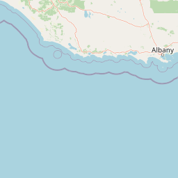
Map view of Greater Dordagup National Park

Use this park location map to pinpoint Greater Dordagup National Park in Australia, understand its exact geographic position, and read its mapped placement within the surrounding landscape more clearly.

Pigeon | © OpenStreetMap contributors

Location context for Greater Dordagup National Park

Western Australia
Recorded earthquake history

Explore Historical Earthquake Records for Greater Dordagup National Park

Examine the recorded seismic history associated with the forested terrain of Greater Dordagup National Park. Review event data including magnitudes and epicentre proximity within this Western Australian protected area to enhance your geographic understanding of the region.

Greater Dordagup National Park Earthquake History

Catalogued events

3 events

Strongest magnitude

Magnitude 5.3

Most recent event

Nov 8, 2018

This history includes earthquakes recorded inside the park or within 50 km of its borders

Park atlas

Explore the regional geography of protected areas, comparing forested landscapes and conservation networks within Western Australia's South West.

Discover Nearby National Parks and Protected Areas Surrounding Greater Dordagup National Park

Continue your exploration from Greater Dordagup National Park by browsing other protected areas, mapping their locations, and comparing diverse forest reserves within Western Australia. This geographic context allows for deeper atlas discovery, revealing how individual parks contribute to the broader conservation landscape of the South West Australian forest belt.
National parkWestern Australia
Park boundaries overlap#1 closest

Southeast

Shannon National Park: A Protected Landscape in Western Australia's Geography

Discover the mapped boundaries and regional park context.

Shannon National Park represents a key protected area within the vast geographic expanse of Western Australia. This entry focuses on understanding its identity as a national park, highlighting its specific landscape character and its contribution to the regional atlas. Through detailed mapping and geographic context, users can explore the protected boundaries and natural setting of Shannon National Park.

Area
525.98 km²
Established
1988
IUCN
II
Relief
Mixed relief
National parkWestern Australia
0 km away#2 closest

North

Sir James Mitchell National Park: National Park, Western Australia - Geographic Atlas View

Mapped protected area with regional landscape context.

Gain a structured understanding of Sir James Mitchell National Park as a key protected landscape within Western Australia. This atlas entry focuses on the park's geographic extent, its status as a national park, and its position within the diverse regional geography of Western Australia, offering clear insights for map-based exploration and conservation landscape analysis.

Area
2.47 km²
Established
1969
IUCN
II
Access
Access unknown
National parkAustralia
0.1 km away#3 closest

South

Jane National Park: Western Australia's Protected Old-Growth Forest Landscape

Mapped forest ecosystems in the South West bioregion.

Jane National Park represents a key protected landscape in the South West of Western Australia, recognized for its significant old-growth forest ecosystems. This Class A reserve preserves mature stands of karri and jarrah trees, offering a glimpse into the region's undisturbed natural heritage. Its landscape is characterized by dense, ancient forests dominating gentle terrain, making it an important site for understanding the conservation value of this bioregion and exploring its mapped natural context.

Area
68.63 km²
Established
2004
IUCN
II
Scope
Terrestrial
National parkAustralia
11 km away#4 closest

South

Boorara-Gardner National Park: Mapped Old Growth Forest and Protected Landscape

Western Australia's protected area and regional geography.

Boorara-Gardner National Park is a vital national park in Western Australia, recognized for its stands of old-growth forest and its stunning spring wildflower displays. Delve into the park's specific geographic features, mapped terrain, and its identity as a key protected area within the South West region. Understand its place in the contiguous network of conservation lands through detailed atlas-style exploration.

Area
110.08 km²
Established
2004
Relief
Mixed relief
Climate
Mediterranean
National parkShire of Manjimup
12 km away#5 closest

East

Boyndaminup National Park: Explore Protected Area Boundaries and Geographic Setting

An Australian national park with distinct mapped landscapes.

Boyndaminup National Park is a key protected area providing rich opportunities for geographic discovery. This atlas-focused entry details its mapped boundaries and situates it within the broader landscape context of the Shire of Manjimup. Understand the park's identity as a national park and its role in Australia's conservation network, offering specific insights for map-based exploration and regional geography.

Area
54.43 km²
Established
2004
IUCN
II
Scope
Terrestrial
National parkWestern Australia
12 km away#6 closest

Northwest

Gloucester National Park: National Park in Western Australia's Geographic Landscape

Explore mapped boundaries and protected land context.

Gloucester National Park stands as a significant protected area within the vast geographic expanse of Western Australia. This entry focuses on its identity as a national park, detailing its mapped landscape features and regional context. Understanding Gloucester National Park involves appreciating its specific geographic setting and its contribution to the atlas of protected natural areas in Australia, providing foundational data for landscape exploration.

Area
8.78 km²
Established
1993
IUCN
II
Access
Moderate access
National parkAustralia
12 km away#7 closest

West

Greater Hawke National Park: Mapped Boundaries of Old Growth Forest Landscape

Explore the protected forest and regional geography.

Greater Hawke National Park offers a significant atlas exploration opportunity for understanding Australia's protected forest ecosystems. This national park preserves critical old growth stands of karri and jarrah trees, showcasing the unique landscape of the Warren bioregion. Its Class A reserve status and adjacency to D'Entrecasteaux National Park highlight its importance as a conservation corridor within the South West of Western Australia. Users can examine the park's geographic setting and its protected-area identity.

Area
140.04 km²
Established
2004
Climate
Mediterranean
Access
Moderate access
National parkWestern Australia
14 km away#8 closest

Southeast

Mount Frankland National Park: Explore Western Australia's Old-Growth Forested Landscape

Granite peaks and unique regional geography within a protected wilderness area.

Mount Frankland National Park in Western Australia is a protected area renowned for its exceptional old-growth karri and red tingle forests, some of the world's tallest tree species. The park's landscape is shaped by low granite hills and dramatic peaks, including the 411-meter Mount Frankland, offering expansive views across the wilderness. As a key component of the Walpole Wilderness Area, this national park provides a rich geographical context for understanding conservation and mapped natural landscapes in Southwest Australia.

Area
373.59 km²
Established
1988
IUCN
II
Relief
Upland

Common questions about visiting, size, designation, and location context for Greater Dordagup National Park

Greater Dordagup National Park FAQs for park facts, access, geography, and protected area context

Find quick answers about Greater Dordagup National Park, including protected-area facts, park geography, trail and visitor context, and how the park fits into its surrounding country and regional landscape.
MoriAtlas Explorer

Continue Your Protected Areas Search Across the Global Atlas

Deepen your exploration by continuing the structured search for national parks and protected areas worldwide. Utilize the comprehensive filtering capabilities to compare different conservation landscapes and refine your understanding of global park geography. Discover more about the distribution and characteristics of protected natural areas.

Global natural geography