Mori Atlas logo
National parkGuadalupe Mabugnao Mainit Hot Spring National Park

Discover mapped boundaries, natural terrain, and unique hydrothermal features within this Philippine national park.

Guadalupe Mabugnao Mainit Hot Spring National Park: Protected Landscape and Geographic Context in Cebu

Guadalupe Mabugnao Mainit Hot Spring National Park represents a vital protected landscape within the Mantalongon mountain range of Cebu, Philippines. This national park, spanning approximately 57.50 hectares, serves as a crucial watershed forest reserve, safeguarding natural hydrothermal features, explored caves like Cave Lorett, and river systems that feed Carcar municipality. Its unique designation as a protected landscape and seascape highlights a blend of ecological preservation and scenic cultural context, making it an important entity for atlas-based geographic discovery.

Hot SpringsCavesWatershed ReserveCebuProtected LandscapePhilippines

Guadalupe Mabugnao Mainit Hot Spring National Park

National park

Park overview

Structured park overview, official facts, and landscape profile for Guadalupe Mabugnao Mainit Hot Spring National Park

Guadalupe Mabugnao Mainit Hot Spring National Park park facts, protected area profile, and essential visitor context

Review the core facts for Guadalupe Mabugnao Mainit Hot Spring National Park, including designation, size, terrain, visitor scale, habitats, and operating context in one park-focused overview.

About Guadalupe Mabugnao Mainit Hot Spring National Park

Guadalupe Mabugnao Mainit Hot Spring National Park represents a significant protected area in the central Philippines, combining ecological conservation with recreational and cultural functions within a relatively compact 57.50-hectare boundary. The park is situated in the Mantalongon mountain range of central Cebu, an area that serves as a critical watershed for downstream communities. The establishment of this protected area in 1972 reflected early Philippine efforts to preserve representative examples of the country's diverse ecosystems and geological features, particularly in densely populated island settings where development pressure threatens natural resources. The park's designation under IUCN Category V indicates a protected landscape approach that accommodates both natural habitat preservation and sustainable human use, a classification that recognizes the park's cultural landscape character arising from the intersection of natural hot springs and human visitation over decades. The Department of Environment and Natural Resources maintains administrative oversight, while the proximity to Cebu City and the municipality of Carcar makes the park accessible for day visitors seeking both relaxation and spiritual enrichment.

Quick facts and research context for Guadalupe Mabugnao Mainit Hot Spring National Park

Guadalupe Mabugnao Mainit Hot Spring National Park covers 57.50 hectares (142.1 acres) of protected landscape in central Cebu, Philippines. The park was established on June 17, 1972 and is managed by the Department of Environment and Natural Resources. It occupies the central Mantalongon mountain range as an important watershed forest reserve. The park features natural hot springs around which visitor facilities including cottages and pools have been developed. The area contains multiple caves, with Cave Lorett and Cave Moymoy being the most explored. A dam within the park supplies water to the municipality of Carcar.

Protection and recognition

Examining the terrestrial boundaries, designation history, and legal framework established in 1972

Guadalupe Mabugnao Mainit Hot Spring National Park Protection Status and History

Guadalupe Mabugnao Mainit Hot Spring National Park represents a dedicated terrestrial protected area established in 1972 to safeguard regional geographic features. Analyzing the formal designation history and protection status of the park provides essential context for understanding regional conservation networks.

Protection details

Protection scope
Terrestrial
Designated year
1972
Park context

Deeper park guide and search-rich context for Guadalupe Mabugnao Mainit Hot Spring National Park

Guadalupe Mabugnao Mainit Hot Spring National Park history, landscape, wildlife, and travel context

Explore Guadalupe Mabugnao Mainit Hot Spring National Park through its history, landscape character, ecosystems, wildlife, conservation priorities, cultural context, and seasonal travel timing in a structured park guide built for atlas discovery and search intent.

Why Guadalupe Mabugnao Mainit Hot Spring National Park stands out

Guadalupe Mabugnao Mainit Hot Spring National Park is best known for its natural hot springs, which serve as the primary visitor attraction and have been developed with cottage accommodations and bathing pools. The park features a distinctive combination of natural hydrothermal resources and religious cultural installations, including life-size statues of saints and the Santo Niño de Cebú, which add a unique spiritual dimension to the visitor experience. The park also contains at least three explored caves, with Cave Lorett being the most extensively documented, along with additional springs and four rivers in its vicinity. The watershed protection function and the presence of a dam supplying Carcar's water needs further distinguish this park from more purely recreational protected areas.

Guadalupe Mabugnao Mainit Hot Spring National Park history and protected-area timeline

Guadalupe Mabugnao Mainit Hot Spring National Park was established on June 17, 1972 through Republic Act No. 6429, representing a wave of national park designations that characterized Philippine environmental policy during the early 1970s. The legislation recognized both the natural significance of the hot springs and surrounding forest areas and the need to protect the watershed function of the Mantalongon mountain range, which provides water resources for the municipality of Carcar. Over the subsequent decades, the park evolved from a purely conservation-oriented protected area into a destination that balances ecological preservation with visitor amenities. The development of cottages and pool facilities around the hot springs reflects this evolution, as does the installation of religious statues that have become part of the park's cultural landscape. The construction and maintenance of the dam within park boundaries further demonstrates the intersection between conservation and community service functions that characterizes this particular protected area.

Guadalupe Mabugnao Mainit Hot Spring National Park landscape and geographic character

The landscape of Guadalupe Mabugnao Mainit Hot Spring National Park is defined by its position in the central Mantalongon mountain range, a forested highland area that rises above the surrounding lowlands of central Cebu. The terrain encompasses both the hot spring areas where hydrothermal activity creates warm water pools, as well as the steep slopes and valleys that channel water through multiple river systems. Cave systems punctuate the landscape, with Cave Lorett and Cave Moymoy representing significant geological features that attract exploration. The park's elevation and forest cover contribute to its watershed function, capturing and filtering precipitation that eventually feeds the dam serving Carcar municipality. The combination of forested slopes, hydrothermal features, caves, and constructed elements such as the dam and visitor facilities creates a complex landscape that reflects both natural processes and human modification.

Guadalupe Mabugnao Mainit Hot Spring National Park ecosystems, habitats, and plant life

The natural character of Guadalupe Mabugnao Mainit Hot Spring National Park centers on its function as a watershed forest reserve within the Mantalongon mountain range. The forest cover provides habitat for species adapted to the moist tropical environments of central Cebu, though the park's relatively small size and the presence of visitor facilities limit the extent of completely undisturbed habitat. The hydrothermal features represent a distinctive geological characteristic, with natural hot springs emerging from underlying thermal sources. The presence of multiple rivers and springs within the park boundary reflects the importance of the area in capturing and conveying water resources. As a protected landscape under IUCN Category V, the park's ecological management approach accommodates both natural habitat preservation and the sustainable use patterns that have developed around the hot springs and associated recreational facilities.

Guadalupe Mabugnao Mainit Hot Spring National Park wildlife and species highlights

The wildlife of Guadalupe Mabugnao Mainit Hot Spring National Park reflects the tropical forest ecosystems of central Cebu, though detailed species documentation is limited in available sources. The watershed forest provides habitat for various bird species, small mammals, and insects typical of Philippine montane environments. The rivers and springs support aquatic organisms adapted to the specific conditions of these freshwater systems. While the park is not primarily known for wildlife observation, the forest remnants and riparian areas provide refuge for species that persist in the modified landscape surrounding the hot spring development zones. The cave systems may harbor specialized species adapted to subterranean conditions, though specific documentation is not available in the source material.

Guadalupe Mabugnao Mainit Hot Spring National Park conservation status and protection priorities

The conservation significance of Guadalupe Mabugnao Mainit Hot Spring National Park derives from multiple factors that collectively justify protected area status. The park's designation as a watershed forest reserve emphasizes its role in protecting water resources for downstream communities, with the dam supplying Carcar's water needs demonstrating this ecosystem service function directly. The IUCN Category V classification reflects a conservation approach that preserves both natural values and cultural landscape character, acknowledging that the hot springs and associated human use represent a legitimate aspect of the park's identity rather than incompatible intrusions. The protection of the Mantalongon mountain range forest cover contributes to soil stabilization, biodiversity preservation, and climate regulation within the heavily populated central Visayas region. The establishment of the park in 1972 represented an early recognition of the need to set aside representative examples of Philippine natural heritage for long-term preservation.

Guadalupe Mabugnao Mainit Hot Spring National Park cultural meaning and human context

Guadalupe Mabugnao Mainit Hot Spring National Park holds cultural significance beyond its natural features, particularly through the religious installations that have become associated with the hot spring area. Life-size statues of saints and Christ, including a prominent representation of the Santo Niño de Cebú, have been placed within the park landscape and contribute to its identity as both a recreational and spiritual destination. This religious dimension reflects the strong Catholic traditions of Cebu province, where the Santo Niño (the Child Jesus) holds particular veneration dating back to the earliest Spanish colonial period. The park's proximity to Carcar municipality and its accessibility from Cebu City make it a convenient destination for both residents and tourists seeking a combination of natural relaxation and cultural enrichment. The development of visitor facilities around the hot springs demonstrates how natural resources have been integrated with cultural practices over time.

Top sights and standout views in Guadalupe Mabugnao Mainit Hot Spring National Park

The primary highlights of Guadalupe Mabugnao Mainit Hot Spring National Park include the natural hot springs with developed cottage and pool facilities, the explored cave systems of Cave Lorett and Cave Moymoy, the religious statuary including the Santo Niño de Cebú, and the park's watershed function serving Carcar municipality. The combination of natural hydrothermal resources, subterranean exploration opportunities, and spiritual cultural elements creates a distinctive visitor experience not commonly found in Philippine protected areas. The trail leading to the caves passes through the park's varied terrain and provides access to additional springs and river viewpoints. The dam, while primarily functional, represents the intersection between conservation and community service that characterizes this park's identity.

Best time to visit Guadalupe Mabugnao Mainit Hot Spring National Park

The hot springs of Guadalupe Mabugnao Mainit Hot Spring National Park can be enjoyed throughout the year, though the dry season from November to April generally offers more comfortable conditions for outdoor activities and exploration. The Philippine climate means that visiting during the cooler dry months provides a more pleasant experience for hiking to caves and enjoying the outdoor hot spring facilities. The wet season from May to October brings increased rainfall that can affect trail conditions and potentially limit cave exploration, though the hot springs remain accessible. Weekday visits may offer a quieter experience compared to weekends, particularly during peak visitor periods around religious observances when the Santo Niño statues attract additional pilgrimage visitors.
Monthly climate preview

Annual temperature cycles and daily precipitation averages for the protected Cebu landscape

Climate and Monthly Weather Normals for Guadalupe Mabugnao Mainit Hot Spring National Park

Long term data at ninety-five meters elevation shows consistently warm monthly mean temperatures spanning twenty-five to twenty-nine degrees Celsius. Comparing the complete twelve month profile clarifies local weather by month, highlighting how daily precipitation averages shift across the year.
Annual mean27 °C
26 °C29 °C
Jan26°
Feb26°
Mar27°
Apr28°
May29°
Jun28°
Jul27°
Aug27°
Sep27°
Oct27°
Nov27°
Dec27°
Warmest month
May

28.8 °C

Coolest month
January

26 °C

Wettest month
October

6.8 mm/day

Driest month
April

2.3 mm/day

Park location guide

Geography guide, regional context, and park location map for Guadalupe Mabugnao Mainit Hot Spring National Park

Guadalupe Mabugnao Mainit Hot Spring National Park park geography, regions, and map view in Philippines

Understand where Guadalupe Mabugnao Mainit Hot Spring National Park sits in Philippines through a broader geographic reading of the surrounding landscape, nearby location context, and its mapped position within the national park landscape.

How Guadalupe Mabugnao Mainit Hot Spring National Park fits into Philippines

The Philippines, officially the Republic of the Philippines, is an archipelagic nation in Southeast Asia comprising approximately 7,641 islands categorized into three main geographical divisions: Luzon, Visayas, and Mindanao. Located in the western Pacific Ocean, it shares maritime borders with Taiwan, Japan, Palau, Indonesia, Malaysia, Vietnam, and China. Manila serves as the capital city, while Quezon City is the most populated city, both within Metro Manila.

Wider geography shaping Guadalupe Mabugnao Mainit Hot Spring National Park in Philippines

The Philippines is an archipelagic nation in Southeast Asia, positioned in the western Pacific Ocean. Its islands are bounded by the South China Sea to the west, Philippine Sea to the east, and Celebes Sea to the south. The country shares maritime borders with Taiwan to the north, Japan to the northeast, Palau to the east and southeast, Indonesia to the south, Malaysia to the southwest, Vietnam to the west, and China to the northwest.

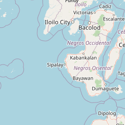
Map view of Guadalupe Mabugnao Mainit Hot Spring National Park

Use this park location map to pinpoint Guadalupe Mabugnao Mainit Hot Spring National Park in Philippines, understand its exact geographic position, and read its mapped placement within the surrounding landscape more clearly.

Pigeon | © OpenStreetMap contributors

Location context for Guadalupe Mabugnao Mainit Hot Spring National Park

Cebu
Park atlas

Map the surrounding protected landscapes across Cebu and the central Visayas, comparing diverse ecosystems and conservation zones.

Discover Nearby Protected Areas and National Parks Around Guadalupe Mabugnao Mainit Hot Spring National Park

After exploring Guadalupe Mabugnao Mainit Hot Spring National Park, browse other protected areas within Cebu and the wider central Visayas region. Compare diverse park geographies, from mountain forest reserves to coastal conservation zones, to understand the regional spread of protected landscapes and their unique features.
Marine protected areaVisayas
About 32 km away#1 closest

North

Tañon Strait Protected Seascape: Marine Geography and Protected Landscape Analysis

An expansive marine passage located within the central Visayas island group.

As the largest marine protected area in the Philippines, the Tañon Strait Protected Seascape represents a complex aquatic geography spanning 160 kilometres. Its protected waters serve as a vital corridor for marine biodiversity, linking the northern Visayan Sea to the southern Bohol Sea. This resource provides a detailed look at the strait's maritime boundaries, coastal ecosystems, and the distinct underwater terrain that defines this critical conservation zone.

Area
5,000 km²
Established
1998
IUCN
V
Scope
Marine
Wildlife reserveCentral Visayas
About 50 km away#2 closest

East

Olango Island Wildlife Sanctuary: Coastal Protected Area and Migratory Bird Habitat in Central Visayas

Explore the interconnected mudflats, reefs, and mangrove forest ecosystems

Olango Island Wildlife Sanctuary stands as a key protected landscape in the Central Visayas, defined by its vast tidal flats and critical role in international bird migration patterns. This site features a unique mosaic of salt marshes, seagrass beds, and coral reef systems that support diverse coastal life within the low-lying terrain of the Olango Island Group.

Area
10.3 km²
Established
1992
Relief
Lowland
Climate
Tropical
National parkNegros Occidental
About 61 km away#3 closest

Northwest

Mount Kanlaon Natural Park: Mapping the Volcanic Heart of Negros Island Protected Lands

A comprehensive geographic overview of volcanic terrain and rainforest habitats.

Mount Kanlaon Natural Park protects a defining massif in the Western Visayas, blending active volcanic features with some of the most intact tropical rainforests remaining on Negros Island. This geographic record maps the transition from steep, high-elevation ridges to lower-altitude forest boundaries, providing context on its importance as a refuge for threatened endemic wildlife and a significant center for regional biodiversity conservation.

Area
248.54 km²
Established
1934
Relief
Mountain
Scope
Terrestrial
National parkCentral Visayas
About 64 km away#4 closest

South

Panglao Island Protected Seascape: Geographic Atlas and Marine Park Boundaries

A vital protected marine zone in Central Visayas

The Panglao Island Protected Seascape acts as a key site for studying tropical marine biodiversity and karst-driven coastal geography in the Philippines. Spanning the waters around Panglao Island, this protected area features a mosaic of coral reefs, white sand beaches, and offshore limestone islets that provide essential habitats for thousands of mollusk and crustacean species.

Area
91.12 km²
Established
2018
Relief
Mixed relief
Scope
Mixed
Protected landscapeBohol
About 74 km away#5 closest

Southeast

Rajah Sikatuna Protected Landscape: Mapping the Limestone Forest of Bohol, Philippines

A vital protected area of karst ridges and endemic forest habitats

Rajah Sikatuna Protected Landscape sits as a premier natural landmark in southern Bohol. This area is defined by its extensive karst topography, significant cave systems, and expansive limestone forests. It serves as an essential ecological anchor for the province, offering a unique perspective on the island's diverse upland geography and natural mountain systems.

Area
104.526 km²
Established
1987
IUCN
V
Relief
Mountain
Wildlife reserveNegros Occidental
About 74 km away#6 closest

West

Ilog-Hilabangan Watershed Forest Reserve: Geography and Protected Forest Boundaries

A vital wildlife reserve and watershed landscape in Negros Occidental

This protected area covers a vast expanse of lowland and montane tropical forest in the heart of Negros Island. By regulating the headwaters of major rivers and maintaining a secure habitat for threatened endemic species, the reserve acts as a fundamental component of the regional geography and biodiversity network in the Western Visayas.

Area
102.11 km²
Established
1990
Relief
Mountain
Scope
Terrestrial
Protected landscapeLeyte
About 122 km away#7 closest

East

Cuatro Islas Protected Landscape/Seascape: Leyte Marine and Island Geography Exploration

Detailed protected area atlas for the Camotes Sea island group

The Cuatro Islas Protected Landscape/Seascape is a notable Philippine conservation zone consisting of four distinct islands including Apid, Mahaba, Digyo, and Himokilan. This geographic profile details the diverse terrain, ranging from uplifted former coral reefs to coral sand islets, while providing a clear understanding of the surrounding marine ecosystem and its role in regional conservation.

Area
125 km²
Established
2000
Scope
Mixed
National parkPhilippines
About 145 km away#8 closest

Northwest

Bulabog Putian National Park: Philippines National Park Geographic Context and Mapped Boundaries

Discover the protected landscape identity and regional atlas significance.

Bulabog Putian National Park stands as a designated national park in the Philippines, offering valuable insights for geographic and protected-area exploration. Users can understand its specific location and mapped presence within the country's natural landscape, contributing to a structured atlas of conservation areas. This entry focuses on the park's identity and geographic setting for informed discovery.

Area
8.543 km²
Established
1961
IUCN
V
Relief
Mountain

Common questions about visiting, size, designation, and location context for Guadalupe Mabugnao Mainit Hot Spring National Park

Guadalupe Mabugnao Mainit Hot Spring National Park FAQs for park facts, access, geography, and protected area context

Find quick answers about Guadalupe Mabugnao Mainit Hot Spring National Park, including protected-area facts, park geography, trail and visitor context, and how the park fits into its surrounding country and regional landscape.
MoriAtlas Explorer

Continue Your Protected Areas Search Across the Global Atlas

Deepen your exploration by continuing the structured search for national parks and protected areas worldwide. Utilize the comprehensive filtering capabilities to compare different conservation landscapes and refine your understanding of global park geography. Discover more about the distribution and characteristics of protected natural areas.

Global natural geography