Mori Atlas logo
Protected landscapeHeckengäu-Weil der Stadt

Examining the ring of forested ridges, orchard slopes, and river valley meadows near Weil der Stadt

Heckengäu-Weil der Stadt Protected Landscape: A Mapped Mosaic of Cultural Geography and Terrain

(Landschaftsschutzgebiet „Heckengäu-Weil der Stadt“)

Heckengäu-Weil der Stadt constitutes a distinct protected landscape encompassing fourteen sub-areas that form a scenic ring around Weil der Stadt in Baden-Württemberg. This geography represents a classic Heckengäu transition zone, featuring a mosaic of traditional orchard meadows, hedge-bordered fields, and stone walls. The terrain bridges the Gäu plateau and the Black Forest foothills, centering on the Würm river valley and the prominent Kuppelzen hill.

protected landscapecultural landscapeorchard meadowsStreuobsthedgerowsHeckengäu

Heckengäu-Weil der Stadt

Protected landscape

Park overview

Structured park overview, official facts, and landscape profile for Heckengäu-Weil der Stadt

Heckengäu-Weil der Stadt park facts, protected area profile, and essential visitor context

Review the core facts for Heckengäu-Weil der Stadt, including designation, size, terrain, visitor scale, habitats, and operating context in one park-focused overview.

About Heckengäu-Weil der Stadt

Heckengäu-Weil der Stadt is a landscape protection area (Landschaftsschutzgebiet) situated in the northwestern part of the Landkreis Böblingen, in the state of Baden-Württemberg, southwestern Germany. Its centerpiece is the historic town of Weil der Stadt, whose medieval core lies south of Stuttgart and whose surroundings include the villages of Merklingen, Münklingen and Hausen an der Würm. The protected area consists of 14 distinct sub-areas that together wrap around the town and its districts, creating a near-continuous ring of protected countryside in an otherwise heavily settled and farmed part of the Stuttgart Region.

The area belongs to the natural region known as the Heckengäu, a landscape name that has become almost a byword in Baden-Württemberg for the historic hedge-and-field mosaic that once characterized the agricultural zone on the eastern edge of the Black Forest. Geographically, Heckengäu-Weil der Stadt sits within the Obere Gäue, the upper Gäu plains, a subdivision of the broader Neckar and Tauber Gäuplatten natural unit. In places, its boundaries overlap with the Natura 2000 site Gäulandschaft an der Würm, reinforcing its ecological rather than purely visual protection value.

What makes Heckengäu-Weil der Stadt especially distinctive is the layered combination of three landscape types that it deliberately conserves. The first is the Würmtalaue, a river valley landscape of near-natural meadows, reeds and riparian woodland along the Würm. The second is the characteristic Heckengäu farmland around the town, with its hedges, stone-walled field borders, small woodlots and orchard slopes, including the historic Landgraben ditch. The third is the forested Kuppelzen hill, whose mixed broadleaf and pine cover defines the local skyline and serves as a key visual landmark.

Beyond preservation, the designation actively aims to prevent further dispersal of settlements into this traditionally open countryside, ensuring that Weil der Stadt retains its setting as a small historic town ringed by a continuous, varied and locally rooted agricultural landscape. For visitors and residents, the protected area functions as an accessible recreational landscape of orchards, meadows and forested ridges within easy reach of the densely populated Stuttgart metropolitan area.

Quick facts and research context for Heckengäu-Weil der Stadt

Heckengäu-Weil der Stadt is a Landschaftsschutzgebiet (IUCN Category V, Protected Landscape) administered by the Landkreis Böblingen. It was established on 20 June 1986 by regulation of the Landratsamt Böblingen, bringing together and replacing earlier smaller protected areas in the region, and is recorded under the identifier 1.15.027 with the World Database on Protected Areas.

The protection covers roughly 17.7 km² across 14 linked sub-areas around Weil der Stadt and its districts Merklingen, Münklingen and Hausen, overlapping in parts with the Natura 2000 site Gäulandschaft an der Würm. Its natural-region classification places it in the Obere Gäue (Upper Gäu Plains) within the Neckar and Tauber Gäuplatten.

Protection and recognition

Terrestrial conservation framework and verified protection data records

Heckengäu-Weil der Stadt Protection Status and Designated Area Records

Examine the documented protection status, management scope, and terrestrial designation records associated with Heckengäu-Weil der Stadt. Structured conservation data provides a reliable overview of the protected area boundaries and international database registration.

Protection details

Protection scope
Terrestrial
Transboundary protection
No
WDPA ID
321464
Park context

Deeper park guide and search-rich context for Heckengäu-Weil der Stadt

Heckengäu-Weil der Stadt history, landscape, wildlife, and travel context

Explore Heckengäu-Weil der Stadt through its history, landscape character, ecosystems, wildlife, conservation priorities, cultural context, and seasonal travel timing in a structured park guide built for atlas discovery and search intent.

Why Heckengäu-Weil der Stadt stands out

The protected area is best known for safeguarding a classic Heckengäu landscape: a finely textured mosaic of orchards, hedge-lined fields, stone ridges (Steinriegel), small wooded copses and meadow valleys that is increasingly rare in southwestern Germany. It also protects the Würm river floodplain near Weil der Stadt, with its near-natural reed-fringed meadows and brookside woodlands, and the wooded Kuppelzen hill crowned with deciduous trees and Scots pine (Forchen). Together these elements form a continuous scenery of orchard slopes, river meadows and forested hilltops that is characteristic of the pre-Black Forest foothill landscapes of the region.
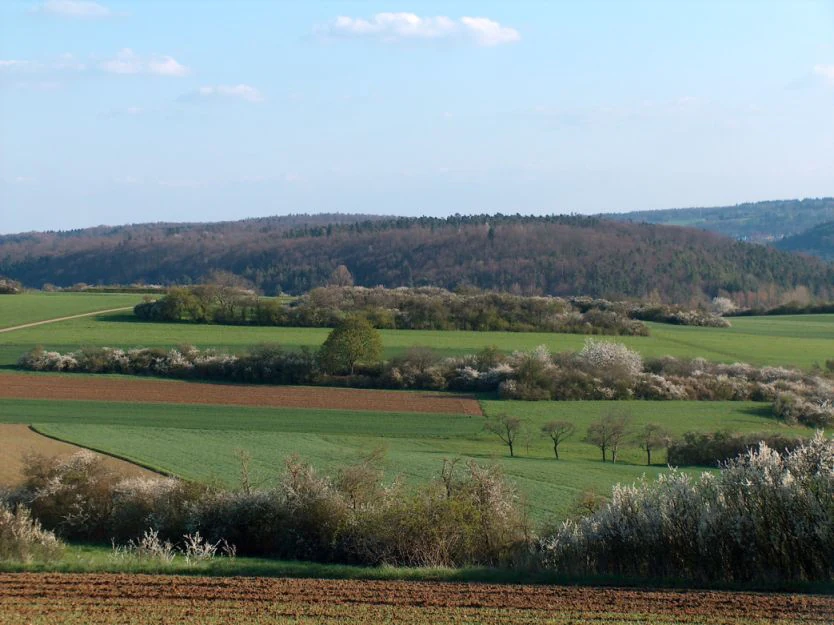
A rural landscape view featuring green meadows and cultivated fields divided by flowering hedgerows, with a forested hill in the background under a blue sky.
A view of the Heckengäu landscape near Weil der Stadt, characterized by rolling hills, fields, and traditional hedges.

Heckengäu-Weil der Stadt history and protected-area timeline

The present-day Heckengäu-Weil der Stadt landscape protection area was established on 20 June 1986 by regulation of the Landratsamt Böblingen. It was created as a unified protection framework that simultaneously ended the earlier independent status of two smaller landscape protection areas in the same region: the area named Kuppelzen und Wolfsgrube, designated on 10 January 1968, and the area named Nördlich Merklingen, designated on 14 November 1968, both of which had previously protected parts of what is now the city of Weil der Stadt.

By consolidating these older designations into a single 14-part landscape protection area, the 1986 regulation brought the whole municipality of Weil der Stadt and its outlying districts under one coherent protective instrument. The protection was framed around preserving both the natural and the cultural landscape elements, including the Würm valley meadows, the orchards, and the historical Landgraben as a cultural heritage feature. Since its designation, Heckengäu-Weil der Stadt has functioned as one of the principal landscape protection areas within the Landkreis Böblingen.

Heckengäu-Weil der Stadt landscape and geographic character

The terrain around Weil der Stadt is gently rolling, sitting on the transition between the Gäu plateau country to the east and the rising foothills of the Black Forest to the west. The protected area inherits this topography, alternating between low ridges, shallow valleys and broader river flats. Visual orientation in the landscape is shaped above all by the wooded Kuppelzen, a rounded hill near the town whose name has become locally synonymous with the protection area itself.

The Würm river valley is a defining structural axis of the area. Here, flat valley bottoms carry near-natural meadows, patches of reed (Schilf) and corridors of streamside woodland that follow the course of the Würm. The valley slopes above the river are cloaked in orchard meadows (Streuobstbestände), a landscape form that has long been a hallmark of this part of Baden-Württemberg. Above the slopes, the plateau and ridge surfaces bear the classic Heckengäu scenery of small fields, hedgerows, dry-stone walls, isolated copses and stretches of woodland, wrapped around the edges of the built-up areas of Weil der Stadt, Merklingen, Münklingen and Hausen an der Würm.

Because the protection area is divided into 14 sub-areas, the landscape reads as a continuous ring rather than a single continuous tract. From most vantage points on the Kuppelzen, along the Würm or from the town's edge, the visual connection between forested ridges, orchard slopes and meadow valleys remains intact and is in fact the central reason for the area's designation.

Heckengäu-Weil der Stadt ecosystems, habitats, and plant life

Ecologically, Heckengäu-Weil der Stadt represents a classic small-scale cultural landscape of high structural diversity. Rather than a single dominant habitat, the protected area is a composite mosaic: river floodplain meadows, reed beds, narrow streambank gallery woodlands, extensively used orchard meadows, hedgerow-and-field complexes, dry stone walls (Steinriegel), small field copses and larger mixed forests on hilltops such as the Kuppelzen.

This mosaic is the foundation of the area's natural value. The mixed forests of the Kuppelzen combine deciduous broadleaf species with Scots pine (Forchen), historically planted here and now part of the visual identity of the hill. Along the Würm, near-natural riparian vegetation with reeds and stream- accompanying shrubs forms a distinct wetland-linked ecological corridor. The orchard meadows and hedgerow-rich farmland hosts a specialized community of birds, insects and small mammals adapted to the long continuity of traditional, low-intensity land use.

The partial overlap with the FFH (Natura 2000) site Gäulandschaft an der Würm represents the strongest formal ecological recognition of the area, underlining the importance of the Würm valley meadows and their adjoining slope and field habitats at European level.

Heckengäu-Weil der Stadt wildlife and species highlights

The wildlife interest of Heckengäu-Weil der Stadt is directly tied to the persistence of its traditional landscape mosaic. The hedge-rich farmland, orchard meadows and small woodland patches of the Heckengäu form nesting and foraging habitat for a wide range of common agricultural-land bird species, while the Würm valley meadows and reed fringes support wetland-associated fauna. Snipe-and-meadow species, amphibians along the Würm and its tributaries, and insects associated with old orchard trees and hedgerows are particularly characteristic.

The Kuppelzen itself, with its mix of broadleaf woodland and pine, hosts typical forest species, including birds and small mammals that benefit from the combination of closed canopy and edge habitat where forest meets orchard slopes. On the broader scale, the area's importance for wildlife lies in the continuity of traditional land use that has not been intensified into closed-field monoculture; this continuity is, by the area's own protection purpose, the factor the designation seeks to defend.

Heckengäu-Weil der Stadt conservation status and protection priorities

As a landscape protection area under the German Nature Conservation framework and an IUCN Category V Protected Landscape, Heckengäu-Weil der Stadt is explicitly an instrument of cultural-landscape conservation rather than strict nature reserve protection. Its purpose, set out in its 1986 regulation, is to preserve the characteristic, attractive pre-Black Forest landscape in its particular individuality, especially its valuable plant sites, its orchards and the wooded Kuppelzen hill, and to maintain these as a recreation space.

A second conservation goal is the protection of the Würm valley's near-natural meadow and streamside woodland, together with the orchard-clad valley slopes and the historic Landgraben ditch as a culturally significant landscape feature. The designation also explicitly aims to prevent further settlement sprawl that would erode the open countryside around Weil der Stadt. In places the boundaries overlap with the Natura 2000 site Gäulandschaft an der Würm, giving the area an additional layer of European-level habitat protection.

Heckengäu-Weil der Stadt cultural meaning and human context

Heckengäu-Weil der Stadt lies around one of the historically significant small towns of the Stuttgart Region. Weil der Stadt is the birthplace of the astronomer Johannes Kepler and carries a substantial medieval-to-early-modern townscape. The protected landscape functions visually as a safeguarding buffer around that historic core, ensuring that the town remains set in a recognizable agricultural landscape rather than an unbroken suburban fringe.

Culturally, the area is also a repository of traditional rural land-use forms typical of the Heckengäu: hedge-bordered fields (hence the regional name Heckengäu, roughly „hedge Gäu“), dry-stone wall field borders (Steinriegel), orchard meadows, the historic Landgraben ditch and the long-standing mosaic of small fields and meadows. These features are not only ecological but cultural-historical evidence of centuries of small-scale farming practice on the Black Forest edge.

Top sights and standout views in Heckengäu-Weil der Stadt

The strongest single feature of Heckengäu-Weil der Stadt is its representation of the Heckengäu landscape as a whole: a coherent ring of hedge-bordered fields, dry stone walls, small woodlots and orchard meadows around Weil der Stadt.

Its secondary highlights include the Würm valley meadows with their reed beds and streamside woodlands, the historically significant Landgraben ditch, the visual landmark of the forested Kuppelzen hill, and the partial overlap with the Natura 2000 site Gäulandschaft an der Würm. Read together, these features make the area one of the best-preserved examples of its particular landscape type in the Landkreis Böblingen.

Best time to visit Heckengäu-Weil der Stadt

As a working cultural landscape rather than a fenced reserve, Heckengäu-Weil der Stadt can be visited year-round, but its visual character shifts strongly with the seasons. Late spring is the most florally expressive period, when orchard meadows come into blossom and the hedge-and-field mosaic of the Heckengäu is at its most vivid.

Summer brings full leaf cover in the Kuppelzen forest and lush meadow vegetation along the Würm, making the area well-suited to walking and recreation. Autumn highlights the orchard harvests and the colour change on the wooded ridges, while winter offers clearer long views across the bare hedge and field network towards Weil der Stadt and the Black Forest edge beyond.

Monthly climate preview

Long-term representative monthly temperature and precipitation data for Heckengäu-Weil der Stadt

Heckengäu-Weil der Stadt Climate Normals and Annual Weather Patterns

Heckengäu-Weil der Stadt exhibits a measured annual climate rhythm ranging from sub-zero winter minimums to warm summer maximums alongside steady daily precipitation averages. Examining the complete twelve-month normals provides detailed comparative depth for understanding long-term regional temperature cycles.
Annual mean8 °C
-1 °C18 °C
Jan-1°
Feb
Mar
Apr
May12°
Jun16°
Jul18°
Aug18°
Sep14°
Oct
Nov
Dec
Warmest month
July

18.1 °C

Coolest month
January

-0.9 °C

Wettest month
July

3.1 mm/day

Driest month
April

1.9 mm/day

Park location guide

Geography guide, regional context, and park location map for Heckengäu-Weil der Stadt

Heckengäu-Weil der Stadt park geography, regions, and map view in Germany

Understand where Heckengäu-Weil der Stadt sits in Germany through a broader geographic reading of the surrounding landscape, nearby location context, and its mapped position within the national park landscape.

How Heckengäu-Weil der Stadt fits into Germany

Germany is a federal republic in Western and Central Europe with a population of over 83 million across sixteen constituent states. It is Europe's largest economy by nominal GDP and a major global exporter and importer. The capital is Berlin, and the country borders Denmark, Poland, Czech Republic, Austria, Switzerland, France, Luxembourg, Belgium, and the Netherlands.

Wider geography shaping Heckengäu-Weil der Stadt in Germany

Germany is located in Western and Central Europe, spanning 357,022 km². It borders Denmark to the north, Poland and the Czech Republic to the east, Austria and Switzerland to the south, and France, Luxembourg, Belgium, and the Netherlands to the west. The country has coastlines on the Baltic Sea and North Sea to the north, with the Alps located in the southern region.

Map view of Heckengäu-Weil der Stadt

Use this park location map to pinpoint Heckengäu-Weil der Stadt in Germany, understand its exact geographic position, and read its mapped placement within the surrounding landscape more clearly.

Pigeon | © OpenStreetMap contributors

Location context for Heckengäu-Weil der Stadt

Baden-Württemberg

Explore photographic records of orchard meadows, river valleys, and forested hills across the protected landscape

Visualizing Heckengäu-Weil der Stadt: Landscape Photography and Protected Scenery

Photographic records reveal the distinct terrain, hedge-bordered fields, and traditional land use defining Heckengäu-Weil der Stadt. Visual documentation of the Würm river valley, orchards, and forested ridges provides deep insight into the protected environment.

A rural landscape view featuring green meadows and cultivated fields divided by flowering hedgerows, with a forested hill in the background under a blue sky.

Park atlas

Compare adjacent conservation areas and regional foothill terrain

Parks Near Heckengäu-Weil der Stadt and Surrounding Protected Landscapes

Browse other protected areas and regional reserves located near Heckengäu-Weil der Stadt to compare adjacent foothill landscapes. Examining connected natural terrain reveals broader ecological patterns across the Baden-Württemberg transition zone.
A watercolor painting showing a wide, panoramic view of a soft, rolling landscape with gentle hills, grassy fields, and small forested areas against a pale, warm sky.
Protected landscapeBaden-Württemberg
About 13 km away#1 closest

Northwest

Neuhausen-Biet: A Protected Landscape at the Edge of the Northern Black Forest in Baden-Württemberg

Mapping the geographic transition between Gäu plateaus and the Würm valley

Neuhausen-Biet serves as an essential protected corridor connecting open agricultural plateaus with the rising, wood-cloaked ridges of the Black Forest fringe. This landscape is characterized by its dramatic transition in topography, featuring the Würm river valley and a complex mosaic of orchards, meadows, and forest blocks within the Enzkreis district. Understanding its boundaries provides insight into regional habitat connectivity.

Area
19.268 km²
Established
2004
IUCN
V
Relief
Upland
Protected landscapeBaden-Württemberg
About 13 km away#2 closest

North

Weissach Protected Landscape: A Geographic Overview of the Heckengäu Mosaic in Germany

Orchard meadows, dry grasslands, and riparian corridors in Baden-Württemberg

Discover the unique geography of the Weissach protected landscape, a five hundred hectare mosaic of traditional orchards, hedges, and small-scale field systems in the Neckar Basin. This atlas entry details the connectivity of its sub-areas, from the Strudelbach valley to the dry grassland slopes, framing the area as a vital component of the broader regional conservation network.

Area
5.782 km²
Established
1994
IUCN
V
Relief
Upland
Protected landscapeBaden-Wuerttemberg
About 14 km away#3 closest

Southeast

Hangflächen um die Pfefferburg: A Protected Landscape in Baden-Württemberg

Orchard meadows, hillside terrain, and local geography.

Hangflächen um die Pfefferburg forms a compact protected landscape defined by its southern-facing orchard meadows and moisture-rich spring zones. Located near Schönaich, the area preserves traditional land-use patterns on a diverse hillside, connecting regional protected zones within the broader geography of the Böblingen district.

Area
0.252 km²
Established
1974
IUCN
V
Relief
Upland
Protected landscapeBaden-Württemberg
About 14 km away#4 closest

Southeast

Ghägnet östlich dem Waldteil Häselhau mit Umgebung: Landscape and Geography Overview

Protected orchard meadows in the Böblingen district of Germany.

This protected landscape in Baden-Württemberg spans 3.1 hectares of Jurassic slope loam soils. It is recognized for its traditional Swabian orchard meadows and wet grassland vegetation, functioning as an ecological corridor adjacent to the Hochberg protected area within the greater Schönbuch forest zone.

Area
0.031 km²
Established
1974
IUCN
V
Protected areaBaden-Württemberg
About 17 km away#5 closest

Northeast

Penal Substitution: Protected Area Mapping and Regional Geography in Baden-Württemberg

Cultural landscape and habitat mosaic overview

Penal Substitution represents a preserved cultural landscape in the German state of Baden-Württemberg, featuring a structured mix of orchard meadows, farmland, and riparian habitats. This area serves as a critical regional green link, where mapped boundaries reveal a complex interplay of agricultural history and active environmental conservation just outside the urban core.

Area
2.586 km²
Established
2004
Relief
Upland
Climate
Temperate
Protected landscapeBaden-Württemberg
About 18 km away#6 closest

Southwest

Teinachtal mit Seitentälern: Protected River Valley Landscape in the Northern Black Forest

Geographic map overview of the Teinach river valley and tributary systems.

The Teinachtal mit Seitentälern protected area serves as a significant conservation zone in the Landkreis Calw. This landscape, integrated with the Naturpark Schwarzwald Mitte and Nord, preserves a richly structured network of stream corridors and forest slopes that connect diverse local habitats.

Area
12.606 km²
Established
2000
IUCN
V
Protected landscapeBaden-Württemberg
About 19 km away#7 closest

Northeast

Wartbiegel - Katharinenlinde und Umgebung: Mapped Protected Landscape and Regional Geography

Traditional orchard mosaic in the Neckar basin, Germany

Discover the geographic structure of Wartbiegel - Katharinenlinde und Umgebung. This protected landscape preserves a unique relief of slopes and agricultural patterns in Baden-Württemberg. The area functions as a vital example of traditional land-use conservation, combining local ecological value with a textured rural landscape near Schwieberdingen.

Area
0.421 km²
Established
1987
IUCN
V
Relief
Upland
Protected landscapeBaden-Württemberg
About 23 km away#8 closest

South

Oberes Ammertal mit dem Seitental Merkental Protected Landscape and Regional Map Context

Baden-Württemberg protected valley and limestone terrain

Situated in the Schönbuch and Glemswald region, this protected area safeguards the upper Ammer valley's meadow floodplains and botanical limestone slopes. It represents a significant mosaic of habitat types; including dry grassland and small quarry-fed water bodies; that maintain the ecological integrity of the local southwestern German geography.

Area
0.202 km²
Established
1982
IUCN
V

Common questions about visiting, size, designation, and location context for Heckengäu-Weil der Stadt

Heckengäu-Weil der Stadt FAQs for park facts, access, geography, and protected area context

Find quick answers about Heckengäu-Weil der Stadt, including protected-area facts, park geography, trail and visitor context, and how the park fits into its surrounding country and regional landscape.
MoriAtlas Explorer

Continue Your Protected Areas Search Across the Global Atlas

Deepen your exploration by continuing the structured search for national parks and protected areas worldwide. Utilize the comprehensive filtering capabilities to compare different conservation landscapes and refine your understanding of global park geography. Discover more about the distribution and characteristics of protected natural areas.

Global natural geography