

Mori Atlas logo
Protected landscapeHells Canyon National Recreation Area

Mapping the dramatic basalt canyons and indigenous heritage of this vast Pacific Northwest landscape

Hells Canyon National Recreation Area: A Geologic and Cultural Landmark of the Snake River

Spanning the rugged border between Oregon and Idaho, Hells Canyon National Recreation Area protects the deepest river gorge in North America. This vast terrain features sheer basalt cliffs plunging into the Snake River, expansive high-country plateaus, and a rich concentration of archaeological sites that record thousands of years of human history. The area offers extensive insight into the complex geological forces and cultural narratives that have shaped the landscapes of the northwestern United States.

national recreation areacanyonriver gorgeSnake Riverdeep canyonwilderness

Hells Canyon National Recreation Area

Protected landscape

Park overview

Structured park overview, official facts, and landscape profile for Hells Canyon National Recreation Area

Hells Canyon National Recreation Area park facts, protected area profile, and essential visitor context

Review the core facts for Hells Canyon National Recreation Area, including designation, size, terrain, visitor scale, habitats, and operating context in one park-focused overview.

About Hells Canyon National Recreation Area

Hells Canyon National Recreation Area protects a sweeping stretch of the Snake River canyon where Oregon and Idaho meet, in a remote and rugged corner of the northwestern United States. The recreation area was established at the end of 1975 by Congress and signed into law by President Gerald Ford, and it was formally dedicated in 1976 with separate ceremonies held in Idaho and Oregon. Management is carried out by the U.S. Forest Service under the umbrella of the Wallowa-Whitman National Forest, with the Snake River serving as the central geographic spine of the protected landscape.

The territory of the recreation area extends across parts of several counties, with the largest portion lying in eastern Wallowa County, Oregon, and smaller portions in southwestern Idaho County, northwestern Adams County, Idaho, and northeastern Baker County, Oregon. This cross-border extent makes the area a shared natural heritage region for both states, with the Snake River forming the natural boundary between them through the canyon itself. The nearest significant town is Grangeville, Idaho, which provides a regional gateway to the rim country and the upper reaches of the recreation area.

Although the area is commonly associated with the deep canyon scenery of the Snake River, the recreation area actually encompasses a much wider landscape than the gorge alone. Above the canyon walls, the land rises into forested ridges, sagebrush plateaus, and alpine-looking high country that contrasts sharply with the narrow river corridor below. This vertical range, from river level to the rims of the surrounding uplands, gives Hells Canyon National Recreation Area a striking ecological and topographic diversity within a single protected unit.

The recreation area offers substantial opportunities for outdoor recreation, including hiking, river-based travel, and camping across multiple developed sites. There are seventeen campgrounds distributed across the area, with Pittsburg Landing serving as the only river-boat launch and RV camping area on the Idaho side and additional campgrounds spread across the Oregon side. The Snake River National Recreation Trail runs along the Idaho side of the river, connecting trailheads and offering long-distance hiking along the canyon.

Equally important is the area's archaeological significance. The Hells Canyon Archeological District, listed on the U.S. National Register of Historic Places in 1984, preserves hundreds of contributing sites, buildings, and structures and showcases extensive rock art traditions. Sites such as Buffalo Eddy and Pittsburg Landing carry thousands of years of human history in their pictographs, making the recreation area a landscape where deep natural heritage and deep cultural heritage are tightly interwoven.

Quick facts and research context for Hells Canyon National Recreation Area

Hells Canyon National Recreation Area covers roughly 650,000 acres along the Oregon-Idaho border in the northwestern United States. The recreation area is managed by the U.S. Forest Service as part of the Wallowa-Whitman National Forest and was established by Congress and signed by President Gerald Ford at the end of 1975, with formal dedication ceremonies in 1976. About 215,000 acres of the area are designated as the Hells Canyon Wilderness, and nearly 900 miles of hiking trails run through the broader recreation area.

Protection and recognition

Examine documented terrestrial protection scope, management frameworks, and official designations.

Hells Canyon National Recreation Area Protection Status and International Recognition

Hells Canyon National Recreation Area maintains a documented terrestrial protection status within its regional landscape. Records outline the designated management scope and official recognition details associated with the protected area.

Protection details

Protection scope
Terrestrial
Transboundary protection
No
Core area
870 km²
Park context

Deeper park guide and search-rich context for Hells Canyon National Recreation Area

Hells Canyon National Recreation Area history, landscape, wildlife, and travel context

Explore Hells Canyon National Recreation Area through its history, landscape character, ecosystems, wildlife, conservation priorities, cultural context, and seasonal travel timing in a structured park guide built for atlas discovery and search intent.

Why Hells Canyon National Recreation Area stands out

Hells Canyon National Recreation Area is best known for containing the deepest section of Hells Canyon along the Snake River, widely recognized as the deepest river canyon in North America. The recreation area is equally defined by its dramatic geological setting: sheer basalt and sedimentary cliffs that plunge thousands of feet toward the Snake River below. Equally central to the park's identity is its exceptional concentration of archaeological sites, including ancient pictograph and petroglyph sites such as Buffalo Eddy and Pittsburg Landing. Together, the deep canyon scenery and the dense cluster of human heritage sites give Hells Canyon National Recreation Area a distinctive dual character as both a natural and a cultural landscape.
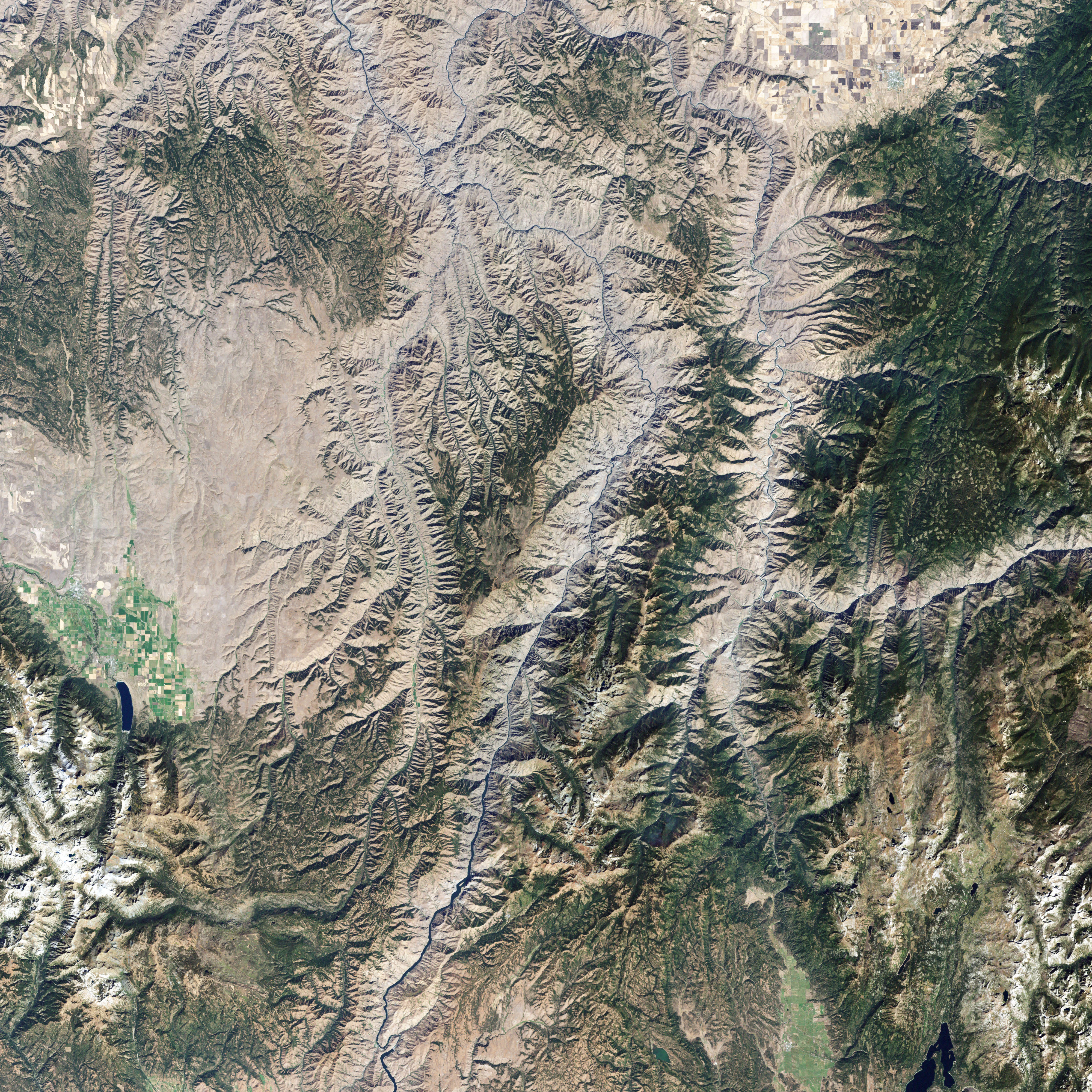
Hells Canyon Satellite View
A Landsat 7 satellite image of the northern section of Hells Canyon, where the Imnaha River joins the Snake River along the Idaho and Oregon border.

Hells Canyon National Recreation Area history and protected-area timeline

Hells Canyon National Recreation Area was established by Congress and signed into existence by President Gerald Ford on December 31, 1975. The protected designation was created to safeguard the historic and archaeological values of the Hells Canyon area and the surrounding reach of the Snake River from Hells Canyon Dam downstream to the Oregon-Washington border. The boundary extended the federal recognition of the region beyond the canyon itself, encompassing the rim lands and river corridor across both Oregon and Idaho.

After its establishment in late 1975, the recreation area was formally dedicated in 1976 through two separate ceremonies reflecting its cross-state character. One ceremony was held in Idaho in June of that year, and another was held in Oregon in late July. The dual dedication underscored the shared significance of the Snake River canyon landscape to both states.

Within the recreation area, the Hells Canyon Archeological District was added to the U.S. National Register of Historic Places on August 10, 1984, formalizing the federal recognition of the area's cultural significance. The archaeological district covers about 12,000 acres and includes 536 contributing sites, 23 contributing buildings, and 58 other contributing structures. This listing helped cement the role of archaeological preservation as a central part of the recreation area's mission alongside natural resource protection.

The Snake River National Recreation Trail, which runs along the Idaho side of the Snake River through the recreation area, was designated in 1980 under the National Trails System Act. Although formally designated relatively recently, the trail itself traces routes and historic paths built up from the late 1800s through approximately the 1930s, showing how the park's modern recreation network overlays older local movement corridors along the river.

Hells Canyon National Recreation Area landscape and geographic character

The defining landscape feature of Hells Canyon National Recreation Area is the Snake River cutting a deep, narrow canyon through layered basalt and sedimentary rock formations along the Oregon-Idaho border. The canyon's depth is its most celebrated geological trait, making it one of the deepest river-cut gorges in North America, and its walls rise dramatically above the river in sheer cliffs, broken benches, and rugged slopes.

Above the canyon, the terrain opens into a broader and more varied high country of forested ridges, rolling plateaus, and sagebrush-covered benchlands. This contrast between the tight, vertical river corridor and the more expansive rim landscapes gives the recreation area a distinctive topographic identity. Elevations climb several thousand feet from the river toward the surrounding ridges, and in places such as Windy Saddle near the Seven Devils Mountains, the landscape reaches alpine-looking elevations above 7,000 feet.

The river itself remains the central thread linking the entire recreation area, shaping drainage patterns, vegetation zones, and human movement routes throughout the region. The Snake River corridor ranges from narrow, river-bound stretches with steep canyon walls to more open reaches where benches and low terraces widen the usable land along the water. This alternation between tight gorge and broader river benches creates the rhythmic scenic character that defines travel through the canyon.

Hells Canyon National Recreation Area ecosystems, habitats, and plant life

The ecological character of Hells Canyon National Recreation Area is shaped by an unusually wide elevation range that falls between the Snake River and the surrounding rims and ridges. At the lower end, hot, dry conditions prevail in the canyon bottom, supporting drought-adapted vegetation along the river benches and lower slopes. As elevation rises, the vegetation grades into montane coniferous forests and open rangelands typical of the interior Pacific Northwest and northern Great Basin.

This vertical zonation produces a mosaic of habitat types packed into a relatively compact geographic footprint. Riparian zones along the Snake River contrast with rocky cliffs, talus slopes, upland forests, and high-country ridges. The combination of canyon walls and river environments creates varied microclimates that contribute to habitat diversity for both resident and migratory wildlife.

Roughly 215,000 acres of the recreation area are designated as the Hells Canyon Wilderness, providing a substantial core of relatively undisturbed habitat. This wilderness designation strengthens the area's ecological significance by protecting large connected tracts of canyon, forest, and rangeland from more intensive development, supporting natural ecological processes across an unusually rugged terrain.

Hells Canyon National Recreation Area wildlife and species highlights

Wildlife in Hells Canyon National Recreation Area reflects the diversity created by the steep transition from arid canyon bottom to forested high country. Bighorn sheep are among the most iconic species associated with the area, navigating the rocky cliffs and ledges of Hells Canyon in small, well-adapted populations. Mule deer, elk, and other ungulates use the upper slopes, benches, and forest edges, especially across the broader rim landscapes that surround the canyon.

The Snake River and its tributaries provide habitat for fish, waterfowl, and riparian-associated species, adding an aquatic and semi-aquatic dimension to the wildlife profile. Raptors such as hawks and eagles are commonly associated with the open canyon terrain, where updrafts along the cliffs support hunting and nesting. Smaller mammals, songbirds, and reptiles occupy the varied vegetation zones from the dry canyon mouth to the higher forested slopes.

The recreation area's combination of wilderness and rugged topography contributes to the area's importance for wide-ranging species that need large, relatively undisturbed habitats. Although hunter and angler activity is part of the regional identity, the protected status of the recreation area helps maintain functional wildlife habitat across a significant portion of the Snake River canyon ecosystem.

Hells Canyon National Recreation Area conservation status and protection priorities

Hells Canyon National Recreation Area was explicitly created for conservation purposes, with its congressional establishment in 1975 aimed at protecting the historic and archaeological values of the Hells Canyon area and the Snake River corridor. The recreation area represents a major federal commitment to safeguarding one of the most significant canyon landscapes in the United States, both for its scenic and ecological value and for its cultural resources.

A core conservation feature is the Hells Canyon Wilderness, which protects roughly 215,000 acres of the recreation area as congressionally designated wilderness. This designation layers strong, long-term protection onto a major portion of the area, helping preserve wilderness character, native vegetation communities, and habitat connectivity across rugged terrain. The presence of a long-distance National Recreation Trail along the Snake River further reflects the federal interest in maintaining low-impact recreational access within the protected landscape.

Equally central to the area's conservation identity is the protection of its archaeological heritage. The Hells Canyon Archeological District, listed on the National Register of Historic Places in 1984, formally recognizes the outstanding cultural value of the region. Together, the area's wilderness, its river corridor, and its archaeological protection form a coordinated conservation framework that emphasizes both natural and cultural preservation.

Hells Canyon National Recreation Area cultural meaning and human context

Hells Canyon National Recreation Area sits in a landscape with thousands of years of human history, expressed most visibly in the extensive rock art and archaeological sites along the Snake River. The Hells Canyon Archeological District contains 536 contributing sites and numerous other structures, documenting long and continuous human use of the canyon and its surrounding terraces. Sites such as Buffalo Eddy, with more than five hundred pictographs, and Pittsburg Landing, where nearly thirty boulders carry pictographs, are important cultural anchors of the recreation area.

The river corridor itself functioned as a travel and communication route for indigenous peoples long before it became a recreational trail. The Snake River National Recreation Trail, designated in 1980, traces older paths built up between the late 1800s and about the 1930s, overlapping with the routes that once linked communities through the canyon. The interpretive site near Pittsburg Landing, with petroglyph and pictograph panels along a short trail, reflects the area's ongoing importance for cultural interpretation and education.

The recreation area's cross-border character, with significant portions in both Oregon and Idaho, also gives it a regional identity that bridges two state-level cultural landscapes while remaining tied to the Snake River as its unifying feature.

Top sights and standout views in Hells Canyon National Recreation Area

Hells Canyon National Recreation Area's defining highlights include its share of the deepest river canyon in North America, its roughly 215,000-acre Hells Canyon Wilderness, and its nationally recognized archaeological district. The Snake River corridor, with its dramatic basalt cliffs and deeply entrenched geologic character, anchors the area's scenic identity, while the long-distance Snake River National Recreation Trail provides extended hiking opportunities along the canyon.

Cultural highlights center on sites such as Buffalo Eddy and Pittsburg Landing, where extensive pictographs and petroglyphs preserve thousands of years of human history in the canyon. With seventeen campgrounds, multiple access points on both sides of the river, and a setting shared between Oregon and Idaho, the recreation area combines natural grandeur with a deep archaeological and geographic story.

Best time to visit Hells Canyon National Recreation Area

The most comfortable periods for experiencing Hells Canyon National Recreation Area are generally late spring through early fall, when weather conditions in the canyon and on the surrounding rims are most suitable for outdoor activity. In the warmer months, river corridors and lower elevations can become quite hot, while higher elevations such as the Windy Saddle area in the Seven Devils Mountains retain cooler conditions, making them especially appealing during summer.

Spring and early summer often bring vivid canyon scenery, with the Snake River at higher flow and vegetation greening across the benches and slopes. Fall introduces cooler temperatures and changing light conditions along the canyon walls, though access to some higher areas becomes more dependent on weather. Winter can be harsh in the high country, and many visitors plan around the milder shoulder seasons for a balanced experience of canyon geology, trails, and archaeological sites.
Monthly climate preview

Long-term representative monthly temperature and precipitation data measurements

Hells Canyon National Recreation Area Climate Normals and Temperature Patterns

Representative coordinates record measured monthly temperature swings from sub-zero winter minimums to warm summer maximums alongside varying daily precipitation rates. Examining the full twelve-month profile provides complete historical averages for detailed geographic study.
Annual mean5 °C
-6 °C18 °C
Jan-6°
Feb-4°
Mar
Apr
May
Jun13°
Jul18°
Aug18°
Sep13°
Oct
Nov-1°
Dec-6°
Warmest month
July

18.2 °C

Coolest month
January

-5.6 °C

Wettest month
December

3 mm/day

Driest month
August

0.6 mm/day

Park location guide

Geography guide, regional context, and park location map for Hells Canyon National Recreation Area

Hells Canyon National Recreation Area park geography, regions, and map view in United States of America

Understand where Hells Canyon National Recreation Area sits in United States of America through a broader geographic reading of the surrounding landscape, nearby location context, and its mapped position within the national park landscape.

How Hells Canyon National Recreation Area fits into United States of America

The United States of America is a federal presidential republic and one of the world's largest countries by area and population. It consists of 50 states across a vast territory spanning multiple time zones, with its capital in Washington, D.C. and largest city in New York City. The nation has a diverse economy, influential political system, and significant cultural and military presence globally.

Wider geography shaping Hells Canyon National Recreation Area in United States of America

The United States occupies a vast territory in North America, bordered by Canada to the north and Mexico to the south. The 48 contiguous states stretch from the Atlantic to the Pacific Ocean, while Alaska occupies the northwestern region and Hawaii is an archipelago in the Pacific. The country encompasses diverse terrain including the Rocky Mountains, Appalachian Mountains, Great Plains, and extensive river systems.

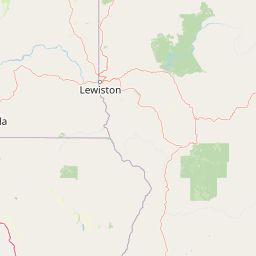
Map view of Hells Canyon National Recreation Area

Use this park location map to pinpoint Hells Canyon National Recreation Area in United States of America, understand its exact geographic position, and read its mapped placement within the surrounding landscape more clearly.

Pigeon | © OpenStreetMap contributors

Location context for Hells Canyon National Recreation Area

IdahoOregon
Natural feature types

Browse the Full Collection of Hells Canyon National Recreation Area Natural Features

Access the complete index of named landforms and hydrologic features linked to Hells Canyon National Recreation Area. Use this structured geographic data to better understand the topography, canyon walls, and river reaches that comprise the most significant gorge system in North America.
Recorded earthquake history

Explore Historical Earthquake and Seismic Activity Data for Hells Canyon National Recreation Area

Examine the recorded seismic history associated with the dramatic topography of Hells Canyon National Recreation Area. This catalogue provides indexed earthquake data for the Snake River region, allowing for an analysis of historical events through magnitude and proximity metrics as presented in the MoriAtlas geographic database.

Hells Canyon National Recreation Area Earthquake Records

Catalogued events

30 events

Strongest magnitude

Magnitude 4

Most recent event

Mar 8, 2023

This history includes earthquakes recorded inside the park or within 50 km of its borders

Visualizing the deep river gorge, basalt cliffs, and protected terrain

Hells Canyon National Recreation Area Photos and Landscape Scenery

Visual documentation captures the dramatic scale of the deepest river canyon in North America through photographs of towering basalt cliffs and the winding Snake River corridor. Examining these protected landscapes reveals the distinct topographic contrast between vertical gorge walls and expansive forested rim country.

Hells Canyon Satellite View

Snake River in Hells Canyon

Park atlas

Compare regional geography and connected wilderness areas across the northwestern terrain

Parks Near Hells Canyon National Recreation Area and Related Protected Landscapes

Browse other parks near Hells Canyon National Recreation Area to evaluate surrounding river gorges, high country plateaus, and forested uplands. Expanding into adjacent protected areas provides deeper regional context for the geological and cultural history of the Pacific Northwest.
Wildlife reserveOregon
Park boundaries overlap#1 closest

Southwest

Eagle Cap Wilderness: Map and Protected Area Overview in Northeastern Oregon

High elevation terrain, glacial valleys, and mountain ecosystems

Spanning over 350,000 acres, Eagle Cap Wilderness defines the high-altitude geography of the Wallowa Mountains. This protected area is characterized by sharp granite ridges, more than 60 named alpine lakes, and deeply carved U shaped glacial valleys. It acts as a primary water source for the region, hosting the headwaters of several major rivers while supporting diverse wildlife populations in a preserved backcountry environment.

Area
1,462.72 km²
Established
1940
IUCN
Ib
Relief
Mountain
Protected landscapeIdaho
Park boundaries overlap#2 closest

South

Payette National Forest: Geographic Overview of Idaho's Rugged Mountain Wilderness

Protected granite landscapes and glacial basin geography

Encompassing a vast portion of central Idaho, Payette National Forest represents a significant protected wilderness corridor. The forest geography transitions from granite-based alpine peaks and deep river gorges to dense coniferous slopes, providing essential habitat and extensive trail connectivity throughout the Northern Rockies.

Area
9,419.55 km²
Established
1944
Relief
Mountain
Access
Access unknown
Protected landscapeOregon
Park boundaries overlap#3 closest

Southwest

Wallowa-Whitman National Forest: A Geographic Overview of Northeastern Oregon Landscapes

Alpine wilderness, mountain ranges, and deep river gorges.

Wallowa-Whitman National Forest protects a vast, varied landscape of granite peaks, alpine meadows, and forested river canyons. This detailed overview covers the geographic significance of the Wallowa and Elkhorn mountains, the Hells Canyon corridor, and the surrounding wilderness regions within Oregon.

Area
9,682 km²
Established
1905
Visitors
505K annual
Relief
Mountain
Wildlife reserveIdaho
37 km away#4 closest

Southeast

Frank Church, River of No Return Wilderness: Idaho Protected Mountain and River Landscapes

Discover massive roadless geography and river-carved mountain terrain.

Spanning over 2.3 million acres in central Idaho, the Frank Church, River of No Return Wilderness represents one of the most significant intact roadless landscapes in the lower 48 states. This protected area features a complex mosaic of coniferous forests, high-altitude alpine ridges, and the steep, jagged canyons of the Salmon River, creating a unique geographic profile for regional exploration.

Area
9,578.21 km²
Established
1980
IUCN
Ib
Relief
Mountain
Protected landscapeOregon
About 90 km away#5 closest

West

Umatilla National Forest: A Comprehensive Atlas of Blue Mountains Protected Landscapes

Explore mountain terrain, wilderness areas, and river-carved geography

Spanning over one million acres, Umatilla National Forest encompasses a complex array of river-cut canyons, high-country ridges, and substantial old-growth woodlands. This protected landscape offers a deep look into the ecological and physical character of the Blue Mountains, from the remote reaches of the Wenaha-Tucannon Wilderness to the headwaters of the Umatilla River.

Area
5,694 km²
Established
1908
Visitors
703K annual
Relief
Mountain
Protected landscapeIdaho
98 km away#6 closest

East

Salmon, Challis National Forest: Geography and Protected Land Map in Central Idaho

Extensive alpine ridges and wild river corridors

Spanning over 4.2 million acres, Salmon, Challis National Forest is a foundational protected landscape in Idaho. This area includes the highest peaks in the state, such as Borah Peak, and holds the majority of the Frank Church, River of No Return Wilderness. Utilize this atlas resource to examine the intricate mountain topography, expansive river systems, and the contiguous wild corridors that define this significant portion of the northern Rockies.

Area
17,142.2 km²
Established
1908
Relief
Mountain
Climate
Temperate
Protected landscapeOregon
110 km away#7 closest

Southwest

Malheur National Forest: Exploring Oregon's Vast Protected Mountain and Desert Landscape

A geographic study of the Blue Mountains and high desert terrain

Spanning over 1.4 million acres, Malheur National Forest represents a complex protected landscape in eastern Oregon. Its geography is defined by a central spine of the Strawberry Mountains, creating a transition zone between arid high desert ecosystems and dense coniferous forests. Known for large wilderness areas and extensive old growth stands, this forest serves as a vital point for understanding the interplay between topographic elevation and regional climate in the Pacific Northwest.

Area
5,929.81 km²
Established
1908
Visitors
242K annual
Relief
Mountain
Protected areaFranklin County
143 km away#8 closest

Northwest

Juniper Dunes Wilderness: Franklin County Protected Area and Landscape Atlas

An arid shrub-steppe and sand dune wilderness in the Columbia Basin.

Juniper Dunes Wilderness protects a rare ecological confluence of active sand dunes and gnarled western juniper groves within eastern Washington. This wilderness remains a significant study in arid-land geography and biogeographic isolation, providing a protected sanctuary for specialized flora and terrain formations within the broader Columbia Basin landscape.

Area
28.9 km²
Established
1984
IUCN
Ib
Relief
Lowland

Common questions about visiting, size, designation, and location context for Hells Canyon National Recreation Area

Hells Canyon National Recreation Area FAQs for park facts, access, geography, and protected area context

Find quick answers about Hells Canyon National Recreation Area, including protected-area facts, park geography, trail and visitor context, and how the park fits into its surrounding country and regional landscape.
MoriAtlas Explorer

Continue Your Protected Areas Search Across the Global Atlas

Deepen your exploration by continuing the structured search for national parks and protected areas worldwide. Utilize the comprehensive filtering capabilities to compare different conservation landscapes and refine your understanding of global park geography. Discover more about the distribution and characteristics of protected natural areas.

Global natural geography