


Mori Atlas logo
Protected areaNatura 2000-område nr. 41 Hjelm Hede, Flyndersø og Stubbergård Sø

A glacial landscape mosaic featuring tunnel valley lakes and outwash heathlands in Central Jutland

Natura 2000-område nr. 41 Hjelm Hede, Flyndersø og Stubbergård Sø Protected Area Geography

This protected area presents a classic demonstration of glacial morphology where a tunnel valley system meets an outwash plain from the last ice age. The site encompasses the elongated waters of Flyndersø and Stubbergård Sø, alongside significant expanses of Hjelm Hede. Mapping this territory reveals a rare mosaic of lobelia lakes, raised bogs, spring mires, and native oak scrub that supports diverse breeding and migratory bird populations.

heathlandglacial landscapetunnel valley lakeraised bogspring mireNatura 2000
A minimalist flat vector illustration showing a tranquil lake nestled between rolling green hills and tall rocky cliffs under a soft sun, with pine trees in the foreground and distance.

Natura 2000-område nr. 41 Hjelm Hede, Flyndersø og Stubbergård Sø

Protected area

Park overview

Structured park overview, official facts, and landscape profile for Natura 2000 Area No. 41 Hjelm Hede, Flyndersø and Stubbergård Sø

Natura 2000 Area No. 41 Hjelm Hede, Flyndersø and Stubbergård Sø park facts, protected area profile, and essential visitor context

Review the core facts for Natura 2000 Area No. 41 Hjelm Hede, Flyndersø and Stubbergård Sø, including designation, size, terrain, visitor scale, habitats, and operating context in one park-focused overview.

About Natura 2000 Area No. 41 Hjelm Hede, Flyndersø and Stubbergård Sø

Natura 2000 Area No. 41 is a Danish conservation site that brings together three closely linked landscape elements: Hjelm Hede, a large heathland area; Flyndersø, a long, winding lake; and Stubbergård Sø, a neighboring lake connected to Flyndersø via the Stubber Å stream. Together they form a single protected territory of about 2,170 hectares in the western part of central Jutland, administered jointly by Skive Kommune and Holstebro Kommune.

The site's defining character is geological. It lies near the former main ice stand-line of the last ice age, where the landscape carries the imprint of both a ground moraine with an associated tunnel valley and a later outwash plain deposited by meltwater. Flyndersø and Stubbergård Sø occupy the tunnel valley, which was originally filled with dead ice, and the surrounding heath plains were shaped by meltwater sands. Dead-ice hollows along the lake flanks have since evolved into smaller lakes and raised bogs, producing the layered glacial landforms that make the area a classic Danish demonstration site for ice age geology.

Ecologically, the site protects a remarkable mosaic of Natura 2000 habitat types despite its relatively modest area. Aquatic habitats include lobelia lakes, charophyte lakes, nutrient-rich lakes, and brown-water dystrophic lakes, while terrestrial habitats range from wet heath and dry heath to acidic grassland, periodically wet meadows, well-developed raised bogs, degraded raised bogs, hanging mires, spring mires, rich fens, beech forest on mor, mixed oak forest, and presumed-native pedunculate oak scrub. The oak scrub along the eastern shore of Flyndersø is considered to be of original, native character.

The area is equally important for birds. Flyndersø and the adjacent Skallesø are designated as a Bird Protection Area, and the wider site supports breeding bittern, osprey, kingfisher, great crested grebe, and red-backed shrike, as well as migratory species including goosander and common goldeneye. The Natura 2000 plan for the area was first adopted in 2011 and has since been continued and refined in later planning periods, coordinated with the Limfjorden water plan.

Quick facts and research context for Natura 2000 Area No. 41 Hjelm Hede, Flyndersø and Stubbergård Sø

Natura 2000 Area No. 41 is a combined Habitats Directive site (H41) and Bird Protection Directive site (F29) covering about 2,170 hectares in central Jutland. It lies partly in Skive Kommune and partly in Holstebro Kommune, within Region Midtjylland. The site unites the heathland of Hjelm Hede with the lakes Flyndersø and Stubbergård Sø, all shaped by glacial processes near the main ice stand-line of the last ice age. It includes notable Natura 2000 habitat types such as lobelia lakes, brown-water lakes, raised bogs, wet and dry heaths, spring mires, and oak-dominated woodlands. The area is also recognized for its breeding and migratory bird populations, including bittern, osprey, kingfisher, and goosander.

Protection and recognition

Documented terrestrial protection scope, designation records, and conservation frameworks

Protection Status and International Recognition for Natura 2000-område nr. 41 Hjelm Hede, Flyndersø og Stubbergård Sø

Terrestrial protection records outline the formal conservation framework established for Natura 2000-område nr. 41 Hjelm Hede, Flyndersø og Stubbergård Sø. Structured documentation compiles available designation data, management context, and recognition sources for this protected landscape.

Protection details

Protection scope
Terrestrial
Transboundary protection
No
Park context

Deeper park guide and search-rich context for Natura 2000 Area No. 41 Hjelm Hede, Flyndersø and Stubbergård Sø

Natura 2000 Area No. 41 Hjelm Hede, Flyndersø and Stubbergård Sø history, landscape, wildlife, and travel context

Explore Natura 2000 Area No. 41 Hjelm Hede, Flyndersø and Stubbergård Sø through its history, landscape character, ecosystems, wildlife, conservation priorities, cultural context, and seasonal travel timing in a structured park guide built for atlas discovery and search intent.

Why Natura 2000 Area No. 41 Hjelm Hede, Flyndersø and Stubbergård Sø stands out

The area is best known for its unusually clear exposure of glacial landscape features from the last ice age, particularly a tunnel valley with an overlying outwash plain and dead-ice lakes. Flyndersø, an approximately eight-kilometer-long lake set in a tunnel valley, is one of the most illustrative examples of this geological sequence in Denmark. Equally distinctive is the combination of rare and varied habitats within a single site: nutrient-poor lobelia-style lakes, brown-water lakes, raised bogs, wet and dry heaths, spring mires, oak-on-sandy-soil forest, and presumed-native pedunculate oak scrub along the eastern side of Flyndersø. This habitat mosaic, together with its designation as a Bird Protection Area, makes the site ecologically significant beyond its modest size.
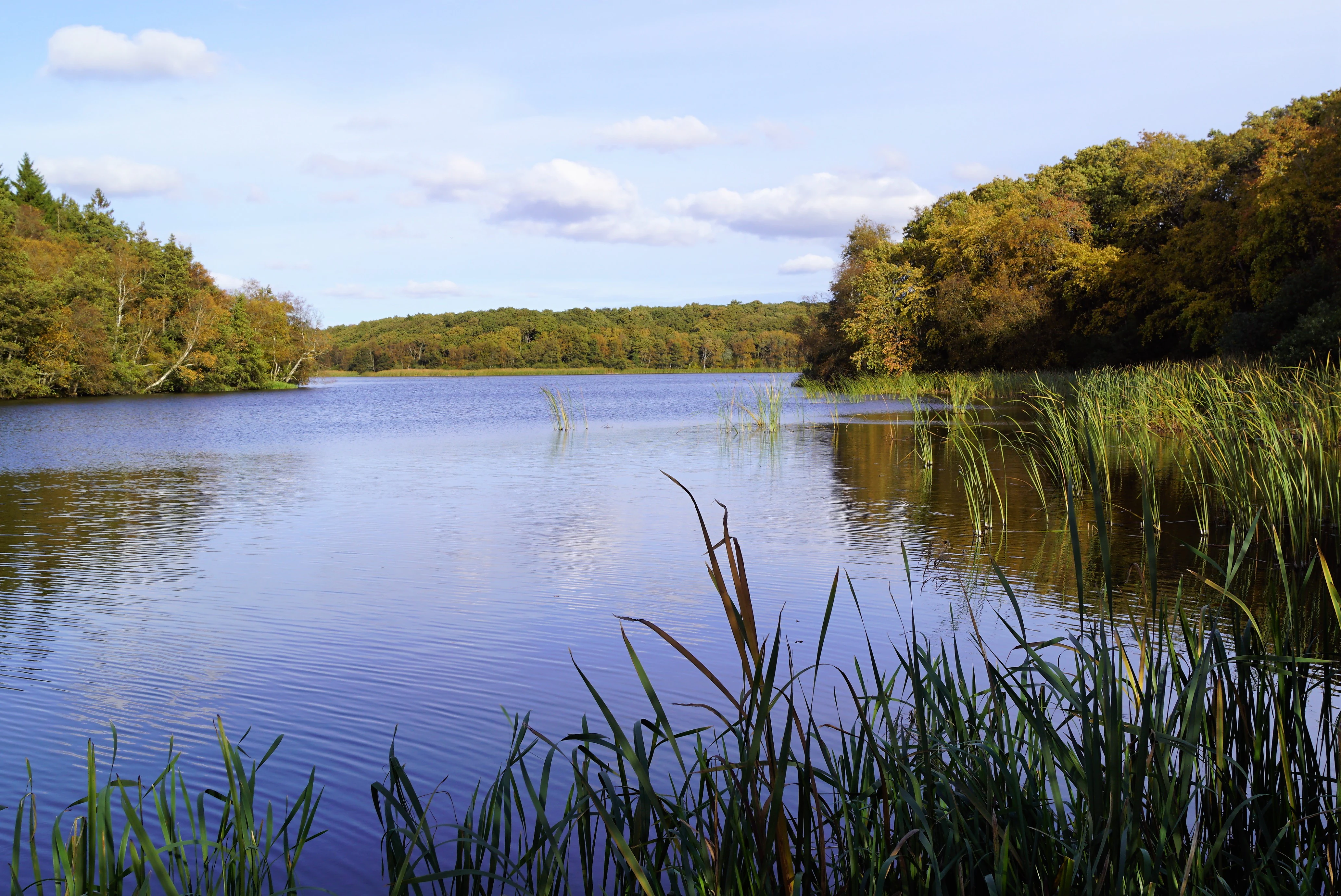
A wide angle view of Flyndersø lake, with lush green trees lining the shore and tall reeds in the foreground.
A view across Flyndersø, showcasing the calm waters surrounded by forested banks.

Natura 2000 Area No. 41 Hjelm Hede, Flyndersø and Stubbergård Sø history and protected-area timeline

The conservation story of the area begins long before Natura 2000. The ruins of Stubber Kloster on the western shore of Stubbergård Sø were placed under protection in 1911. A 1,200-hectare estate of heathland, plantations, and lake around Flyndersø was then formally protected in stages in 1934 and 1967, followed by an additional 438 hectares around Stubbergård Sø in 1980, and 107 hectares at Stampestrømmen south of Stubbergård Sø in 2001.

The origin of this protection tradition lies in private initiative. In 1910, the businessman H.P. Hjerl Hansen purchased part of the heathland at the southern end of Flyndersø in order to preserve it. These lands were later transferred to a foundation, on which the open-air museum Hjerl Hede was eventually established, linking the site's natural conservation history to its wider cultural heritage around Salling.

In 2011, the area was formally adopted as a Natura 2000 plan, combining Habitats Directive site H41 and Bird Protection Area F29 under a single management framework. The plan was developed through binding action plans prepared by the involved municipalities and the Danish Nature Agency, and it has since been updated in subsequent planning periods. It is also coordinated with the Limfjorden Water Plan 1.2, reflecting the area's connection to the broader Limfjord catchment.

Natura 2000 Area No. 41 Hjelm Hede, Flyndersø and Stubbergård Sø landscape and geographic character

The landscape of Natura 2000 Area No. 41 is a textbook example of layered glacial morphology. Its deepest structure is a ground moraine crossed by a tunnel valley, while its upper layer is an outwash plain left by meltwater near the main ice stand-line of the last ice age. The tunnel valley was filled with dead ice, and as that ice slowly melted it created a chain of lakes and hollows that define the area's present-day topography.

Flyndersø is the most prominent feature of this system: an approximately eight-kilometer-long lake occupying two large basins connected by a narrow strait, known as Snævringen. To its south, Stubbergård Sø is a roughly 4.5-kilometer-long lake in the same tunnel valley system, connected hydrologically to Flyndersø by the Stubber Å stream. South of Stubbergård Sø, water exits the area toward the Limfjord through Stampestrømmen.

Around the lakes, the outwash plain appears as broad flat heathlands, of which Hjelm Hede is the largest surviving expanse, excluding former conifer plantations and cultivated land. Along the eastern shore of Flyndersø, irregular pedunculate oak scrub grows on the moraine-derived soils, while Estvadgård Plantage on the western shore introduces a contrasting block of mostly coniferous plantation, only a small portion of which lies within the Natura 2000 boundary. The combined effect is a strongly patterned terrain of open water, boggy hollows, sand flats, heath, oak scrub, and planted forest.
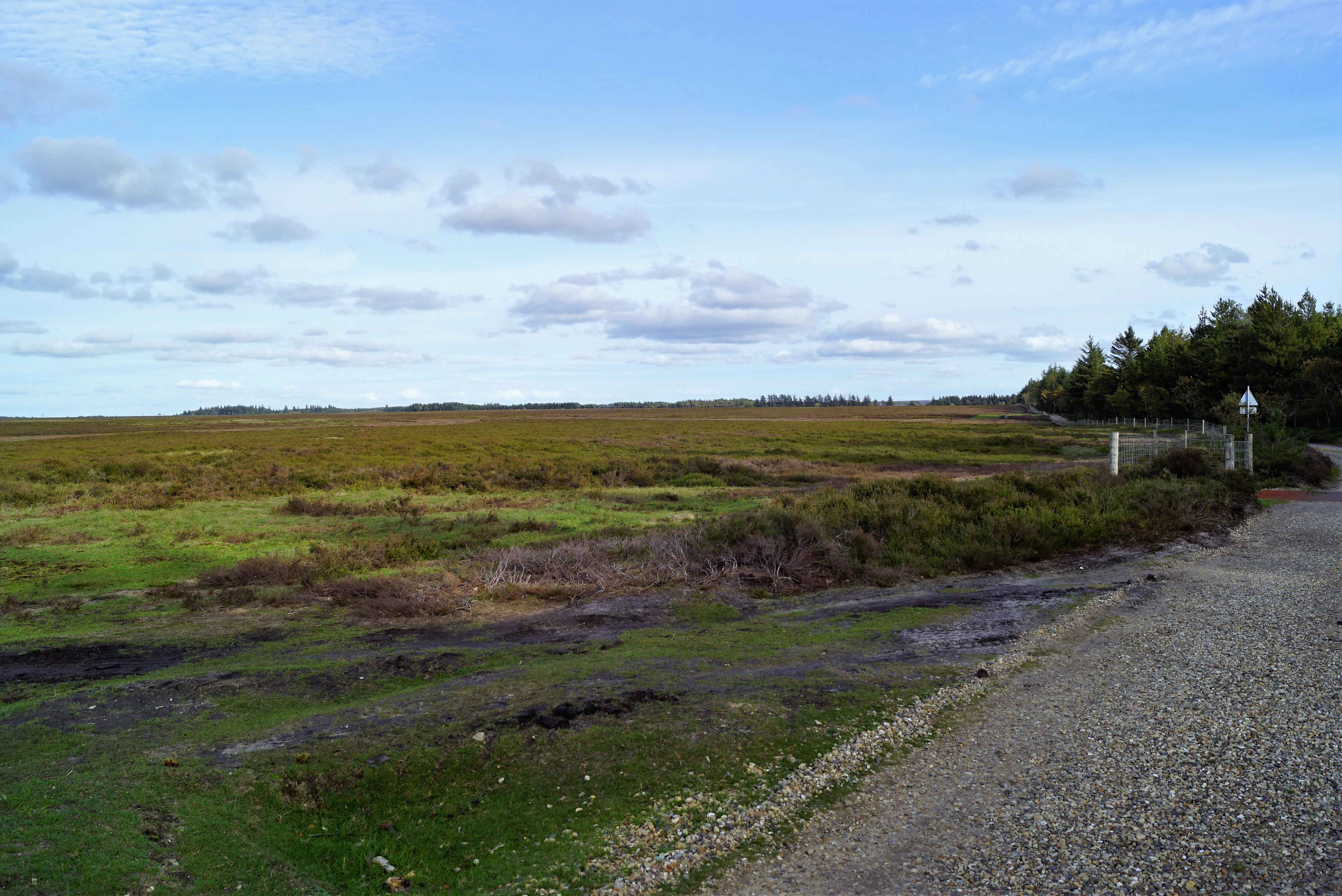
A wide, open expanse of heathland in Denmark with low-lying vegetation under a blue sky, viewed from a gravel path.
A view across the open heathlands of Hjelm Hede.

Natura 2000 Area No. 41 Hjelm Hede, Flyndersø and Stubbergård Sø ecosystems, habitats, and plant life

The site protects a striking concentration of habitat types for its size. Aquatic habitats include clear, nutrient-poor lobelia lakes and charophyte lakes, as well as nutrient-rich and brown-water dystrophic lakes; the Flyndersø is documented as eutrophic and turbid, with limited submerged plant development, while Stubbergård Sø preserves a different character within the same valley system.

Terrestrial habitats are equally diverse. Hjelm Hede supports extensive wet and dry heath, often with a well-developed lichen flora, alongside acidic grassland and periodically wet meadows. The bog complex surrounding the lakes includes active raised bog, degraded raised bog, and hanging mires, together with spring mires and rich fens fed by groundwater seepage at the transition between the heath and the valley.

Forest and scrub habitats include oak forest on sandy mor soils, mixed oak forest, and the presumed-original pedunculate oak scrub along the eastern shore of Flyndersø, often considered one of the more significant oak communities in Denmark. Smaller and ecologically notable features include bog woodland and alder-ash swamp forest along mires and seepage zones, providing habitat continuity that supports rare specialist species such as lichens and bryophytes associated with long-undisturbed, humid woodland.
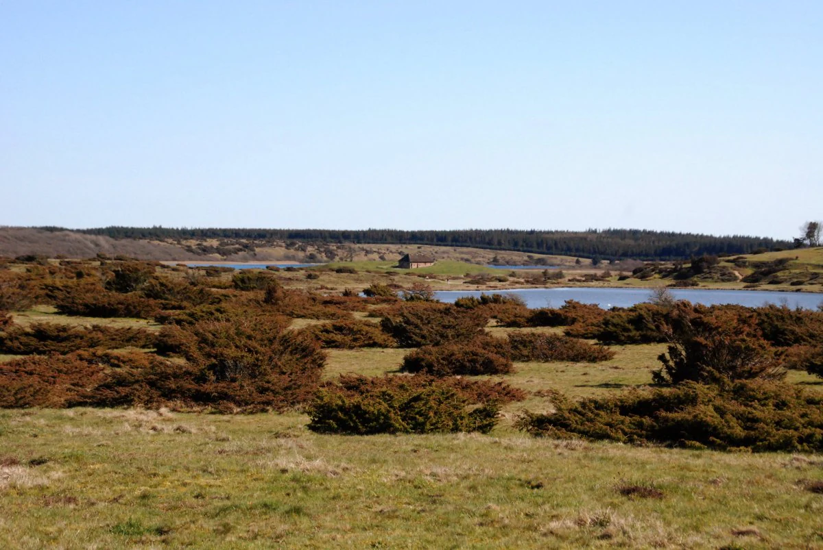
A wide view of a low-lying heathland with scattered bushes and small trees leading toward a distant lake under a clear sky.
A view of the heathland landscape near the lakes of the Hjelm Hede and Stubbergård Sø area.

Natura 2000 Area No. 41 Hjelm Hede, Flyndersø and Stubbergård Sø wildlife and species highlights

The area is one of the more important bird sites in central Jutland. Flyndersø and Skallesø are designated as a Bird Protection Area because of their significance for both breeding and migratory waterbirds.

Breeding species of note include bittern, osprey, kingfisher, great crested grebe, and red-backed shrike, the latter favoring the open heathland with scattered scrub. The lake system also serves as a staging and wintering area for migratory waterbirds, with documented records of goosander and common goldeneye, among others.

Beyond birds, the Habitats Directive listing identifies otter as a key mammal species of the area, reflecting the health of the lake and stream system, while the great crested newt is recorded from the area's ponds. The site's long continuity of humid woodland habitat also supports specialist bryophytes such as the rare liverwort Nowellia curvifolia on decaying wood, an indicator of habitat stability rather than a charismatic species but ecologically significant.

Natura 2000 Area No. 41 Hjelm Hede, Flyndersø and Stubbergård Sø conservation status and protection priorities

The area is protected at multiple levels. At the European level it forms part of the Natura 2000 ecological network, combining a Habitats Directive site (H41) and a Bird Protection Directive site (F29). At the national level it has benefited from successive Danish nature conservation decrees, beginning with the 1911 protection of Stubber Kloster and continuing through 1934, 1967, 1980, and 2001 protections around the lakes and heath.

Its conservation value lies in the unusually complete representation of glacial landscape features and habitats within a relatively small area, including nutrient-poor lakes that are now rare in Denmark due to widespread eutrophication. The combination of still-active raised bogs, spring mires, and rich fens gives the site a particular role in protecting peat-forming and groundwater-dependent habitats, while the oak communities along Flyndersø are valued as potentially original, long-established woodland.

Management is coordinated through binding action plans prepared by the municipalities and the Danish Nature Agency, initially under the 2011 Natura 2000 plan and updated in later planning cycles. The plan is also coordinated with the broader Limfjord Water Plan, recognizing that protection of the lakes' ecological character depends on managing nutrients and hydrology across the wider catchment.

Natura 2000 Area No. 41 Hjelm Hede, Flyndersø and Stubbergård Sø cultural meaning and human context

The cultural context of the area is shaped by the monastic past and by private conservation initiative. Stubber Kloster, a medieval Cistercian monastery whose ruins lie on the western shore of Stubbergård Sø, was the site's earliest formally protected cultural feature, placed under preservation in 1911. The monastery once managed the surrounding lands and waters and remains a landmark of regional identity in the Salling area of Jutland.

The conservation tradition of the surrounding heath was established independently of the state. In 1910, the businessman and philanthropist H.P. Hjerl Hansen bought a portion of the heathland at the southern end of Flyndersø in order to preserve it. This land was later handed to a foundation, and it now hosts the Hjerl Hede open-air museum, which presents traditional rural buildings and ways of life from the region.

Together, the monastic ruins, the protected heath, and the open-air museum link the site to a longer story of stewardship, in which private initiative and state regulation have together preserved a landscape that today holds both ecological and cultural value.

Top sights and standout views in Natura 2000 Area No. 41 Hjelm Hede, Flyndersø and Stubbergård Sø

One of Denmark's clearest demonstrations of glacial landscape features near the main ice stand-line of the last ice age, where a tunnel valley with dead-ice lakes is overlain by a meltwater outwash plain.

A compact but unusually varied Natura 2000 habitat mosaic that includes lobelia and brown-water lakes, raised bogs, spring mires, wet and dry heath, and presumed-origin pedunculate oak scrub along the eastern shore of Flyndersø.

A designated Bird Protection Area, notable for breeding bittern, osprey, and kingfisher, as well as migratory waterfowl such as goosander, set within lakes connected by the Stubber Å stream.

A long conservation history joined to regional heritage, from the 1911 protection of the Stubber Kloster ruins through H.P. Hjerl Hansen's private preservation of the heath and the later Hjerl Hede open-air museum, to the formal Natura 2000 plan adopted in 2011.

Best time to visit Natura 2000 Area No. 41 Hjelm Hede, Flyndersø and Stubbergård Sø

The area can be appreciated across much of the year, but its character shifts strongly with the seasons. Late spring and early summer are when wetland and mire habitats are most active, heath plants are in flower, and breeding birds such as bittern, kingfisher, and red-backed shrike are easiest to observe around Flyndersø and Skallesø.

Late summer and early autumn bring quieter conditions and a softer palette across the heaths and bog surfaces, while autumn migration can bring new populations of waterfowl, including goosander, to the lakes. Winter tends to emphasize the openness and scale of the glacial landscape, with low light across the heath plains and clear visibility along the elongated shores of Flyndersø, though ice and short daylight limit accessibility. Visitors interested primarily in birdwatching generally benefit from spring through autumn, while those focused on landscape and geology can engage with the site year-round when conditions allow.

Monthly climate preview

Long-term representative temperature and precipitation normals measured across twelve months

Natura 2000-område nr. 41 Hjelm Hede, Flyndersø og Stubbergård Sø Climate and Weather by Month

Historical climate records for Natura 2000-område nr. 41 Hjelm Hede, Flyndersø og Stubbergård Sø document moderate seasonal temperature shifts alongside steady year-round precipitation patterns at a sampled coordinate. Reviewing the complete twelve-month statistical profile provides detailed insight into long-term meteorological averages across the protected terrain.
Annual mean8 °C
1 °C17 °C
Jan
Feb
Mar
Apr
May11°
Jun14°
Jul17°
Aug17°
Sep14°
Oct
Nov
Dec
Warmest month
August

16.7 °C

Coolest month
February

1.2 °C

Wettest month
October

3.2 mm/day

Driest month
April

1.7 mm/day

Park location guide

Geography guide, regional context, and park location map for Natura 2000 Area No. 41 Hjelm Hede, Flyndersø and Stubbergård Sø

Natura 2000 Area No. 41 Hjelm Hede, Flyndersø and Stubbergård Sø park geography, regions, and map view in Denmark

Understand where Natura 2000 Area No. 41 Hjelm Hede, Flyndersø and Stubbergård Sø sits in Denmark through a broader geographic reading of the surrounding landscape, nearby location context, and its mapped position within the national park landscape.

How Natura 2000 Area No. 41 Hjelm Hede, Flyndersø and Stubbergård Sø fits into Denmark

Denmark is a constitutional monarchy and Nordic country in Northern Europe. It is the southernmost of the Scandinavian countries, bordering Germany to the south, Norway to the north, and Sweden to the southwest. The country consists of the Jutland peninsula and an archipelago of islands, with Copenhagen as its capital and largest city. Denmark has a population of over 6 million and is characterized by flat, arable land, sandy coasts, and a temperate climate.

Wider geography shaping Natura 2000 Area No. 41 Hjelm Hede, Flyndersø and Stubbergård Sø in Denmark

Denmark occupies the Jutland peninsula and roughly 406 islands in Northern Europe. It is situated between the North Sea to the west and the Baltic Sea to the east. The country borders Germany to the south and is connected to Sweden via the Øresund Bridge. Denmark is predominantly flat terrain with low elevation, the highest point being Møllehøj at 170.86 meters.

Map view of Natura 2000 Area No. 41 Hjelm Hede, Flyndersø and Stubbergård Sø

Use this park location map to pinpoint Natura 2000 Area No. 41 Hjelm Hede, Flyndersø and Stubbergård Sø in Denmark, understand its exact geographic position, and read its mapped placement within the surrounding landscape more clearly.

Pigeon | © OpenStreetMap contributors

Location context for Natura 2000 Area No. 41 Hjelm Hede, Flyndersø and Stubbergård Sø

Region Midtjylland

Explore protected habitats, glacial terrain, and landscape character through curated photography.

Visualizing Natura 2000-område nr. 41 Hjelm Hede, Flyndersø og Stubbergård Sø Photos and Scenery

Visual records illustrate the layered glacial morphology, tunnel valley lakes, and extensive heath plains defining Natura 2000-område nr. 41 Hjelm Hede, Flyndersø og Stubbergård Sø. Detailed imagery clarifies the diverse protected habitats and topographic features spanning the surrounding region.

A wide angle view of Flyndersø lake, with lush green trees lining the shore and tall reeds in the foreground.

A wide view overlooking Stubbergård Sø, a calm lake surrounded by grassy fields, wetlands, and distant treelines under an overcast sky.

A wide, open expanse of heathland in Denmark with low-lying vegetation under a blue sky, viewed from a gravel path.

A wide view of a low-lying heathland with scattered bushes and small trees leading toward a distant lake under a clear sky.

Park atlas

Discover adjacent protected areas and regional glacial landscapes across central Jutland

Exploring Parks Near Natura 2000-område nr. 41 Hjelm Hede, Flyndersø og Stubbergård Sø

Browse other protected landscapes and glacial terrain connected to the broader geographic context surrounding Natura 2000-område nr. 41 Hjelm Hede, Flyndersø og Stubbergård Sø. Comparing nearby reserves helps contextualize regional habitat mosaics, tunnel valley formations, and local conservation history.
A soft watercolor illustration of a lake landscape with green trees, reeds in the foreground, and a distant shoreline under a pale sky.
Protected areaMidtjylland
About 1.8 km away#1 closest

Northeast

Flyndersø Protected Area and Heath Lake Geography in Midtjylland, Denmark

Mapped heathland, lake basins, and protected conservation terrain

Flyndersø occupies a distinctive low-lying landscape in Midtjylland, distinguished as Denmark's largest heath lake. The area features two primary water basins linked by a narrow channel, set amidst a historic expanse of managed heath and conifer plantation woodland that serves as a central protected site for regional conservation.

Area
4.18 km²
Established
1934
Relief
Lowland
Climate
Temperate
Protected areaMidtjylland
About 2.2 km away#2 closest

Northwest

Skallesø Protected Area: Mapping the Lakes and Heathlands of Central Jutland

Aquatic habitats, historic heath, and inland river connectivity.

Skallesø represents a focal point for inland conservation in central Jutland. This detailed entry maps its unique basin and its integration into the Hjerl Hede cultural landscape. Study the lake's ecological margins, its bird-protection status, and the hydrologic link provided by the Hindså to the wider river network, showcasing a century of dedicated conservation efforts.

Area
0.737 km²
Relief
Lowland
Scope
Terrestrial
Water
Water-dominated
Nature reserveRegion Midtjylland
About 4.2 km away#3 closest

Northwest

Skånsø og Tranemose Nature Reserve: Geographic Profile and Protected Area Context

Mapped habitats in the Central Jutland region of Denmark

The Skånsø og Tranemose nature reserve showcases the interplay of glacial landforms and historical land use. Situated in Region Midtjylland, this area serves as a significant protected site where visitors can examine the geography of Lobelia-rich clear lakes alongside the brown-water remnants of an exploited raised bog. The site provides essential ecological structure within its broader plantation environment.

Area
0.84 km²
Established
2011
Relief
Lowland
Scope
Terrestrial
Protected areaRegion Midtjylland
About 7.2 km away#4 closest

North

Skørsø Protected Area: Mapped Geography and Habitat Context in Region Midtjylland

Natural glacial basin and rare aquatic ecosystem in Central Denmark

The Skørsø site offers a detailed look at a rare clearwater, nutrient-poor lake basin formed by post-glacial processes. The protected area features a unique, unfragmented transition between open water and wet heath vegetation, serving as a critical refuge for specialized flora and protected wildlife within the cultivated landscape of Denmark.

Area
0.12 km²
Established
2011
Water
Major water bodies
Protected areaRegion Midtjylland
About 17 km away#5 closest

West

Natura 2000-område nr. 62 Veno, Veno Sund: Protected Coastal and Marine Landscape Map

Regional geography and protected coastal habitat overview

Analyze the protected area characteristics of Natura 2000-område nr. 62 Veno, Veno Sund, where shallow brackish sound meets dune heaths and calcareous grasslands. This site provides essential habitat for waders and marine mammals within the broader Limfjorden ecosystem in Region Midtjylland.

Area
29.26 km²
Established
2011
Relief
Lowland
Climate
Temperate
Nature reserveRegion Midtjylland
About 18 km away#6 closest

South

Sønder Feldborg Plantage Nature Reserve: Geographic Overview and Protected Landscapes

Heath, mire, and lake habitats in Region Midtjylland

Sønder Feldborg Plantage preserves a rare assembly of central Jutland habitats, spanning hanging bog, brown-water lakes, and heath mosaics. This protected area stands as a primary example of peatland restoration and conservation within the larger plantation landscape, offering a dense concentration of rare Danish ecological features in a 120-hectare site.

Area
1.2 km²
Established
2011
Relief
Lowland
Water
Minor water
Protected areaCentral Denmark Region
About 22 km away#7 closest

Southeast

Natura 2000-område nr. 40 Karup Å, Kongenshus og Hessellund Heder Landscape and Maps

Central Denmark Region protected heath and river corridors

Investigate the natural terrain of this expansive Natura 2000 protected area. Analyze the distinct combination of the unregulated Karup Å river valley, rich fen systems, and the vast inland heathlands of Kongenshus and Hessellund that characterize this vital Central Denmark geographic feature.

Area
38.01 km²
Established
2011
Relief
Lowland
Climate
Temperate
Protected areaDenmark
About 22 km away#8 closest

Northwest

Nissum Bredning Protected Area: Geography and Coastal Mapping in Denmark

Shallow bay ecosystems, glacial cliffs, and Limfjorden sand flats.

Nissum Bredning is a broad, low-lying basin in western Denmark known for its extensive shallow sand flats, including Fjordgrund and Gåseholm. The protected area encompasses a diverse coastal mosaic of brackish lagoons, salt meadows, and the distinctive Toftum Bjerge glacial cliff. This geography offers a clear view into the intersection of active North Sea currents and sheltered inland fjord environments.

Area
200 km²
Relief
Lowland
Climate
Temperate
Access
Easy access

Common questions about visiting, size, designation, and location context for Natura 2000 Area No. 41 Hjelm Hede, Flyndersø and Stubbergård Sø

Natura 2000 Area No. 41 Hjelm Hede, Flyndersø and Stubbergård Sø FAQs for park facts, access, geography, and protected area context

Find quick answers about Natura 2000 Area No. 41 Hjelm Hede, Flyndersø and Stubbergård Sø, including protected-area facts, park geography, trail and visitor context, and how the park fits into its surrounding country and regional landscape.
MoriAtlas Explorer

Continue Your Protected Areas Search Across the Global Atlas

Deepen your exploration by continuing the structured search for national parks and protected areas worldwide. Utilize the comprehensive filtering capabilities to compare different conservation landscapes and refine your understanding of global park geography. Discover more about the distribution and characteristics of protected natural areas.

Global natural geography