
Mori Atlas logo
Nature reserveHördter Rheinaue

Understanding the fluvial dynamics, alluvial forest structure, and riverine terrain within the German Rhine valley.

Hördter Rheinaue Nature Reserve: A Mapped Exploration of the Upper Rhine Floodplain Forest

(Naturschutzgebiet Hördter Rheinaue)

Hördter Rheinaue represents a significant protected area within the Upper Rhine floodplain of Rhineland-Palatinate, showcasing an intricate network of oxbow lakes, sloughs, and mature Auwald forest. This landscape offers deep insight into the natural flood dynamics and sedimentary history of the Rhine rift valley. Explore the boundaries of this protected habitat, where integrated wetland ecosystems, reed-fringed channels, and old river arms converge to sustain diverse avian communities and rare alluvial forest life.

floodplain forestAualdUpper Rhineriverine habitatoxbow lakeswetlands
A graphic illustration of a mountain valley featuring a winding river, evergreen forest, cliffs, and a waterfall under a bright sun.

Hördter Rheinaue

Nature reserve

Park overview

Structured park overview, official facts, and landscape profile for Hördter Rheinaue

Hördter Rheinaue park facts, protected area profile, and essential visitor context

Review the core facts for Hördter Rheinaue, including designation, size, terrain, visitor scale, habitats, and operating context in one park-focused overview.

About Hördter Rheinaue

Hördter Rheinaue sits in the heart of the Upper Rhine Graben's floodplain, between the towns of Germersheim, Hördt and Leimersheim, in the German state of Rhineland-Palatinate. Its roughly 818 hectares protect an exceptionally well-preserved section of the historical Rhine floodplain, where active river dynamics, old meanders and groundwater patterns have produced a patchwork of habitats ranging from soft- and hardwood alluvial forest to open water, reedbeds, meadows and the smaller side channels known locally as Schluten.

The reserve is best understood as part of a much larger protected landscape. It belongs to the landscape protection area "Pfälzische Rheinauen" (Palatinate Rhine Floodplains), which forms the largest coherent stretch of Auwald in Rhineland-Palatinate and extends across district boundaries. Within this larger framing, Hördter Rheinaue combines national protection as a Naturschutzgebiet with European protection as a Natura 2000 site, both as a Flora-Fauna-Habitat area and as a Bird Protection Area. The European designation, in fact, extends further than the national reserve and incorporates neighboring protected features such as the Eichtal-Brand, the Leimersheimer Altrhein and the Neupotzer Altrhein, showing how the protected-area layers interlock spatially.

Floodplain function is central to the reserve's identity. Plans are in place to designate part of the area as a controlled flooding zone for extreme Rhine floods exceeding a roughly 200-year return period, with preparatory ecological flooding designed to maintain the floodplain forest and its associated habitats under future hydrological conditions. This combination of historic protection status and forward-looking floodplain management gives the area a profile that is more about active ecological landscape stewardship than simple passive conservation.

For visitors and researchers, Hördter Rheinaue is a textbook example of a Rhine floodplain still in working hydrological relationship with the river. Its network of Michelsbach and other old channels, combined with the surrounding Auwald, makes it a strong reference site for Rhineland-Palatinate's floodplain conservation strategy and an important node in a network of oxbow lakes and alluvial forests that together define the ecological character of the northern Upper Rhine lowlands.

Quick facts and research context for Hördter Rheinaue

Hördter Rheinaue is a nature reserve (Naturschutzgebiet) of about 818 hectares in the Landkreis Germersheim, Rhineland-Palatinate, lying in the natural region of the Nördliche Oberrhein-Niederung. It has been protected by national ordinance since 14 December 1966, originally issued by the Bezirksregierung Neustadt an der Weinstraße and now administered under the Struktur- und Genehmigungsdirektion Süd.

Since 2004 the area has been part of the European Natura 2000 network as both a Flora-Fauna-Habitat site (code DE6816301, around 2,378 hectares) and a Bird Protection Area (code DE6816402). It is recorded internationally with WDPA / CDDA code 4399 and is classified as an IUCN Category IV habitat and species management area. The reserve is embedded in the larger landscape protection area "Pfälzische Rheinauen", which represents the largest coherent stretch of floodplain forest in Rhineland-Palatinate.

Protection and recognition

Documented terrestrial boundaries, management scope, and Natura 2000 listings

Hördter Rheinaue Protection Status and International Recognition Data

Terrestrial protection records compile the formal conservation scope and recognized boundaries established for Hördter Rheinaue. Verified data sources document official Natura 2000 framework listings associated with the protected landscape geography.

International recognition

Protection details

Protection scope
Terrestrial
Transboundary protection
No
WDPA ID
4399
Park context

Deeper park guide and search-rich context for Hördter Rheinaue

Hördter Rheinaue history, landscape, wildlife, and travel context

Explore Hördter Rheinaue through its history, landscape character, ecosystems, wildlife, conservation priorities, cultural context, and seasonal travel timing in a structured park guide built for atlas discovery and search intent.

Why Hördter Rheinaue stands out

The reserve is best known for being the oldest and, until recently, the second-largest nature reserve in the district of Germersheim, and for protecting a remarkably intact Rhine floodplain landscape of oxbows, sloughs and Auwald. It is also notable as a hub for the broader Palatinate Rhine floodplains, where multiple protected-area layers, from national NSG status to European Natura 2000 designations, overlap to safeguard one of the state's largest remaining floodplain forest complexes. Among nature enthusiasts, the area is recognized especially for its birdlife, including high-density and regionally important populations of black kite, kingfisher, grey-headed woodpecker, middle spotted woodpecker, great cormorant and common teal, as well as the presence of the northern crested newt.
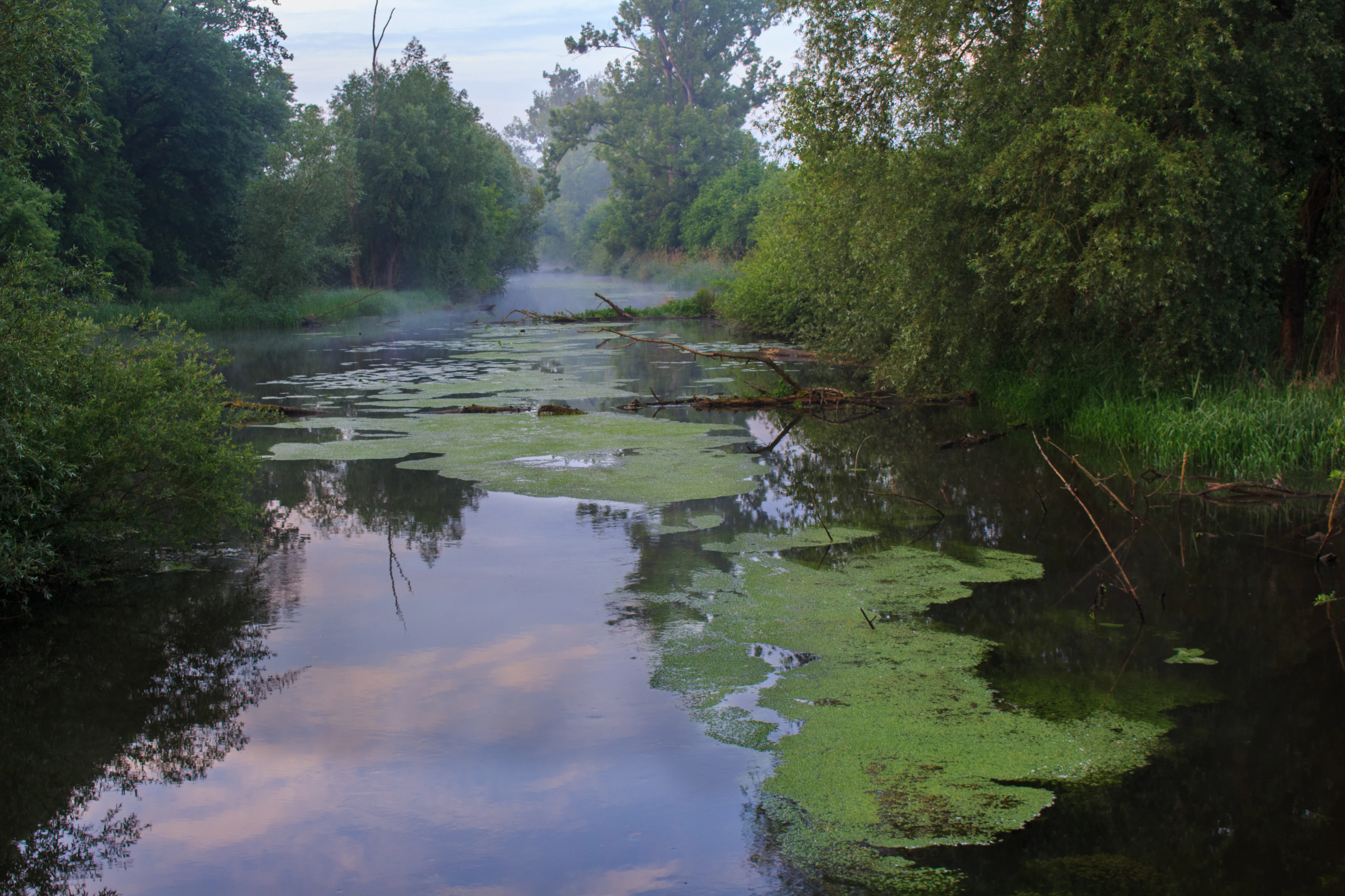
A calm waterway winding through a dense, lush green forest in the Hördter Rheinaue nature reserve, with soft morning mist visible in the distance and patches of algae floating on the surface.
A serene view of the Hördter Rheinaue floodplain, featuring mist on the water and dense surrounding vegetation.

Hördter Rheinaue history and protected-area timeline

The formal protection of Hördter Rheinaue began on 14 December 1966, when the Bezirksregierung Neustadt an der Weinstraße, predecessor to today's Struktur- und Genehmigungsdirektion Süd, designated the area as a Naturschutzgebiet under then-applicable German nature conservation law. Within the Landkreis Germersheim, it holds the distinction of being the oldest nature reserve and, until later additions, the second-largest in the district.

In 2004 its profile was significantly expanded at the European level. The area became part of the Natura 2000 network both as a Flora-Fauna-Habitat site under the EU Habitats Directive (site code DE6816301, covering roughly 2,378 hectares) and as a Bird Protection Area under the Birds Directive (site code DE6816402, "Hördter Rheinaue inklusive Kahnbusch und Oberscherpfer Wald"). This European designation broadened the spatial scope beyond the original national reserve and connected it institutionally with neighboring protected features such as the Leimersheimer Altrhein, the Neupotzer Altrhein and, in a separate designation, the Wörth oxbow with harbor.

More recent planning reflects an evolving role for the area in regional flood risk management. The reserve has been identified as the planned location for a controlled flooding zone intended to absorb extreme Rhine flood events, with accompanying ecological flooding measures designed to keep the floodplain forest and its associated habitats resilient under future hydrological stress.

Hördter Rheinaue landscape and geographic character

Hördter Rheinaue lies within the natural region of the Nördliche Oberrhein-Niederung, the northern Upper Rhine lowlands, a landscape defined by the geological legacy of the Rhine Rift Valley and by centuries of river dynamics. The terrain here is flat to gently undulating alluvial ground, shaped by braided channels, abandoned meanders, backswamps and the slow accumulation of river sediments. Elevations are low, and the defining visual character comes from water and woodland rather than relief.

The dominant landscape features are the old river arms and sloughs. The Michelsbach, which runs through the reserve, is a slow, meandering remnant of former Rhine activity, while broader oxbows such as the Leimersheim and Neupotz Altrheine frame the area to the east and link it hydrologically with neighboring protected sites. Scattered Schluten, small side channels that once carried floodwater through the floodplain, cut through the alluvial forest and add to the structural diversity of the terrain.

Above the channel network stretches the Auwald itself: a multilayered canopy of softwood species such as willow and poplar on the youngest, most frequently flooded ground, giving way further back to older, more stable stands of hardwood alluvial forest. Between these forested zones lie open meadows, reed-fringed water bodies and transitional wetland edges, producing the kind of small-scale mosaic that has become rare along heavily engineered stretches of the Rhine.

Hördter Rheinaue ecosystems, habitats, and plant life

The ecological identity of Hördter Rheinaue is that of a functional Rhine floodplain, a habitat type that has been dramatically reduced elsewhere in central Europe. The mosaic of softwood and hardwood alluvial forest, combined with permanent open water, seasonal pools, reed margins and small-scale clearings, supports a rich gradient from aquatic to terrestrial conditions within a compact area. This complexity is the foundation of the site's biodiversity value and the reason it qualifies under the EU Habitats Directive.

At the habitat level, the reserve is closely tied to the Annex I habitat types typical of dynamic alluvial systems: riparian forests of willow, poplar and alder along the active channels, and more stable hardwood floodplain forests on slightly higher ground. The network of oxbows, sloughs and the slow-flowing Michelsbach provides the hydrological continuity that these woodland communities, and the species that depend on them, require to persist.

The reserve also functions as an ecological corridor within the larger Palatinate Rhine floodplain landscape. Because its boundaries overlap with both the landscape protection area and the European Natura 2000 designations, the habitats it contains are not isolated patches but are functionally connected to similar floodplain communities along the Upper Rhine, allowing for species movement and recolonization across a broader geographic scale.

Hördter Rheinaue wildlife and species highlights

The wildlife profile of Hördter Rheinaue is dominated by its birdlife, which is precisely why the area carries a separate EU Birds Directive designation alongside its Habitats Directive status. Recent surveys highlight the reserve for breeding or regularly occurring populations of black kite, common kingfisher, grey-headed woodpecker, middle spotted woodpecker, great cormorant and common teal, several of which occur at high densities and are considered regionally important.

Many of these species are listed under Annex I of the EU Birds Directive, including the bluethroat and black woodpecker as additional examples observed in the area, and the reserve is therefore explicitly managed to maintain the conditions these birds need. The combination of open water, old trees with nest cavities, reed-fringed channels and adjacent wet woodland allows a single site to support both fish-eating specialists like the kingfisher, woodland-dependent woodpeckers and waterfowl such as teal.

Beyond birds, the reserve is also documented as habitat for the northern crested newt, a species of conservation concern in many parts of central Europe. The presence of amphibians alongside the rich avifauna underlines the value of the area's network of standing water bodies and sloughs, which provide breeding and foraging habitat for a wide range of groups rather than any single taxonomic focus.

Hördter Rheinaue conservation status and protection priorities

Conservation at Hördter Rheinaue operates on multiple overlapping layers. At the national level, the area has been a state-ordained Naturschutzgebiet since 1966, with the primary goal of preserving its characteristic floodplain landscape, habitats and species assemblages. At the European level, the 2004 designations as a Flora-Fauna-Habitat site and as a Bird Protection Area tie the reserve into the Natura 2000 network, obligating Germany to maintain or restore a favorable conservation status for the habitats and species listed in the relevant EU directives.

The site is registered internationally with WDPA / CDDA code 4399 and classified as an IUCN Category IV habitat and species management area, reflecting its role as an actively managed protected landscape rather than a strict wilderness reserve. Its protection also extends outward at the landscape scale through the larger Landschaftsschutzgebiet "Pfälzische Rheinauen", ensuring that the floodplain forest mosaic on which the reserve depends is buffered against incompatible land use beyond its formal boundaries.

A distinctive component of its conservation profile is the planned designation as a controlled flooding zone for extreme Rhine flood events. The intent is to use the reserve's hydrological position to absorb overbank flooding in cases of severe high water, while running preparatory ecological flooding events to keep the Auwald and its associated habitats adapted to periodic inundation. This makes the reserve an example of integrated floodplain conservation, where biodiversity protection and regional flood risk management are pursued together rather than treated as competing objectives.

Hördter Rheinaue cultural meaning and human context

The reserve sits within a region shaped by long-standing human interaction with the Rhine. The town of Germersheim, whose southern outskirts border the protected area, has historical roots as a fortress town and crossing point on the river, while the villages of Hördt, Leimersheim and the former community of Sondernheim, now part of Germersheim, all contribute territory to the reserve. The historical Auwald landscape itself reflects centuries of shifting river courses, canal projects and floodplain land use that have left their mark on settlement patterns and local identity.

More broadly, the area belongs to the cultural landscape of the Palatinate Rhine floodplains, where traditional uses such as meadow grazing, small-scale fishing in the oxbows and timber from the alluvial forest have coexisted with river engineering and flood protection works. Today, the overlapping conservation designations represent a conscious shift in how this landscape is valued, recognizing the cultural and ecological significance of an Auwald landscape that grew out of, and is now maintained alongside, centuries of human presence along the Rhine.

Top sights and standout views in Hördter Rheinaue

Hördter Rheinaue combines the rarity of an intact Rhine floodplain forest with unusually layered conservation recognition: a long-standing national nature reserve that is simultaneously a Natura 2000 habitat and bird protection area, embedded in the largest contiguous Auwald complex in Rhineland-Palatinate.

Its highlights include the Michelsbach and associated network of oxbows and sloughs, the well-developed mosaic of softwood and hardwood alluvial forest, and a bird community strong enough that several Annex I species, including breeding black kite, kingfisher and grey-headed woodpecker, are documented at high densities. The reserve's planned role as a controlled extreme-flood zone adds a forward-looking dimension often missing from older protection sites, linking conservation with regional climate and flood adaptation.

Best time to visit Hördter Rheinaue

As a floodplain forest reserve, Hördter Rheinaue rewards visits whenever water levels and weather permit walking along its edges, but the experience varies meaningfully with season. Spring and early summer bring high waterbird activity, with breeding species such as kingfisher, black kite and various woodpeckers most observable against fresh foliage and active channels. Reed and wetland vegetation is at its most developed in late spring and summer, while autumn brings changing colors in the Auwald and migrant waterfowl to the oxbows and sloughs.

Winter can be quiet but rewarding for waterbirds, especially on unfrozen sections of the old Rhine arms, though site accessibility depends on ground conditions and any active flood management. Because flooding is part of the reserve's natural and planned hydrology, visitors should generally expect a dynamic landscape in which water levels, rather than the calendar, set much of the visit's character.

Monthly climate preview

Long-term temperature and precipitation patterns from representative coordinates

Hördter Rheinaue Climate Normals and Annual Weather by Month

Representative coordinate records for Hördter Rheinaue outline a measured annual sequence of monthly mean temperatures ranging from near freezing to warm mid-summer maximums alongside consistent daily precipitation. Examining the complete twelve-month climate profile reveals deeper baseline trends across temperature thresholds and long-term precipitation averages.
Annual mean10 °C
1 °C21 °C
Jan
Feb
Mar
Apr10°
May15°
Jun19°
Jul21°
Aug20°
Sep16°
Oct10°
Nov
Dec
Warmest month
July

20.9 °C

Coolest month
January

0.6 °C

Wettest month
May

2.3 mm/day

Driest month
April

1.5 mm/day

Park location guide

Geography guide, regional context, and park location map for Hördter Rheinaue

Hördter Rheinaue park geography, regions, and map view in Germany

Understand where Hördter Rheinaue sits in Germany through a broader geographic reading of the surrounding landscape, nearby location context, and its mapped position within the national park landscape.

How Hördter Rheinaue fits into Germany

Germany is a federal republic in Western and Central Europe with a population of over 83 million across sixteen constituent states. It is Europe's largest economy by nominal GDP and a major global exporter and importer. The capital is Berlin, and the country borders Denmark, Poland, Czech Republic, Austria, Switzerland, France, Luxembourg, Belgium, and the Netherlands.

Wider geography shaping Hördter Rheinaue in Germany

Germany is located in Western and Central Europe, spanning 357,022 km². It borders Denmark to the north, Poland and the Czech Republic to the east, Austria and Switzerland to the south, and France, Luxembourg, Belgium, and the Netherlands to the west. The country has coastlines on the Baltic Sea and North Sea to the north, with the Alps located in the southern region.

Map view of Hördter Rheinaue

Use this park location map to pinpoint Hördter Rheinaue in Germany, understand its exact geographic position, and read its mapped placement within the surrounding landscape more clearly.

Pigeon | © OpenStreetMap contributors

Location context for Hördter Rheinaue

Landkreis GermersheimRheinland-Pfalz
Recorded earthquake history

Explore Historical Earthquake Records Associated with Hördter Rheinaue

Review a structured collection of seismic events recorded in the vicinity of Hördter Rheinaue. This MoriAtlas catalogue provides map-based access to historical data, allowing for clearer understanding of regional seismic activity without implying hazard or causation.

Hördter Rheinaue Earthquake History

Catalogued events

13 events

Strongest magnitude

Magnitude 3.5

Most recent event

Feb 16, 2008

This history includes earthquakes recorded inside the park or within 50 km of its borders

Explore photographic records of alluvial forests, oxbow lakes, and protected wetland habitats

Hördter Rheinaue Photos and Landscape Scenery: Visualizing the Upper Rhine Floodplain

Visual documentation reveals the intricate network of old river channels, oxbow lakes, and continuous alluvial forest spanning the Upper Rhine floodplain. Studying these protected-area views provides clear insight into the rare wetland habitats and riverine terrain defining the reserve.

A calm waterway winding through a dense, lush green forest in the Hördter Rheinaue nature reserve, with soft morning mist visible in the distance and patches of algae floating on the surface.

Park atlas

Compare connected floodplain forests, oxbow lakes, and adjacent riverine nature reserves

Parks Near Hördter Rheinaue and Protected Areas in the Upper Rhine Region

Browsing other protected areas near Hördter Rheinaue reveals the broader network of alluvial forest habitats and riverine reserves across the Upper Rhine floodplain. Expanding the geographic comparison helps trace similar wetland ecosystems, oxbow networks, and lowland conservation corridors throughout the surrounding region.
Soft watercolor painting of an oxbow lake landscape with green riverbanks, trees, and distant rolling hills against a pale sky.
Nature reserveRhineland-Palatinate
Mapped location lies within the park boundary#1 closest

South

Leimersheimer Altrhein Nature Reserve: Mapped Geography and Protected Area Context

A preserved Rhine oxbow ecosystem in Rhineland-Palatinate

Leimersheimer Altrhein represents a rare, enduring fragment of the historical Rhine floodplain. This site hosts vital waterbird populations within an enclosed water landscape, providing essential habitat connectivity in a heavily regulated river region. Gain insights into the specific terrain, boundary configurations, and riparian mosaic that define this protected nature reserve.

Area
15 km²
Established
2004
IUCN
IV
A soft, light watercolor painting of a wetland scene with a winding river branch, reeds, and low-lying greenery under a hazy sky.
Nature reserveRheinland-Pfalz
Park boundaries overlap#2 closest

Southwest

Neupotzer Altrhein Nature Reserve: A Detailed Map and Geographic Overview

Protected floodplain landscape in the Rheinland-Pfalz region.

The Neupotzer Altrhein reserve stands as a prominent example of Rhine floodplain recovery, featuring a diverse topography of slow-moving water channels, marshes, and softwood alluvial forests. Located in the Rheinland-Pfalz district of Germersheim, this protected area offers significant insight into the historical and natural shifts of the Rhine corridor, serving as a key refuge within the European Natura 2000 network.

Area
2.375 km²
Established
2000
IUCN
IV
Relief
Lowland
A watercolor painting showing a soft, atmospheric landscape with a foreground of water and green grasses, a midground of trees, and purple mountains in the background under a pale yellow sky.
Nature reserveRhineland-Palatinate
Park boundaries overlap#3 closest

Southwest

Rheinniederung Neuburg-Wörth: A Protected Floodplain Landscape in Rhineland-Palatinate

An analysis of river meanders, oxbows, and floodplain forest geography

This nature reserve encompasses a 14.5 square kilometer corridor of the Upper Rhine, featuring a distinct topography of hardwood forests, wet meadows, and aquatic habitats. The site remains a focal point for understanding Rhine river dynamics and the conservation of rare floodplain ecosystems like the Wörther Altrhein.

Area
14.48 km²
Established
2004
Relief
Lowland
Climate
Temperate
Nature reserveRheinland-Pfalz
About 0.9 km away#4 closest

Southwest

Wörther Altrhein Nature Reserve: Protected Wetland Atlas and Upper Rhine Landscape Context

Mapped conservation zones within the Rheinland-Pfalz floodplain

Investigate the protected landscape of Wörther Altrhein, an ecologically important former Rhine channel. This site offers a unique study in wetland geography, where controlled hydrology supports diverse reedbeds and alluvial forest habitats within the industrial backdrop of the southern Upper Rhine.

Area
2.4 km²
Established
2004
IUCN
IV
Relief
Lowland
Nature reserveRhineland-Palatinate
About 2.5 km away#5 closest

Northwest

Bellheimer Wald: Protected Alluvial Forest and Inland Dune Geography in Germany

Nature reserve landscapes in Rhineland-Palatinate

Bellheimer Wald offers a window into the unique geography of the Upper Rhine Plain. This protected forest is characterized by its sandy alluvial soils and rare inland dune systems, forming a core component of the alluvial-fan woodland chain that spans the southern Palatinate and supports complex habitats for specialized flora and fauna.

Area
46.79 km²
Established
2000
IUCN
IV
Relief
Lowland
A horizontal watercolor painting depicting a soft-focus landscape with a central tree, calm water, and rolling hills in the background.
Nature reserveRhineland-Palatinate
About 2.7 km away#6 closest

North

Brückenkopf Nature Reserve: An Atlas of Protected Floodplain Geography in Rhineland-Palatinate

Detailed mapping of rare wetland habitats and regional floodplain zones

Brückenkopf offers a unique look at small-scale habitat conservation in the Germersheim district. This nature reserve protects a vital fragment of the Upper Rhine floodplain, serving as a sanctuary for specific wetland flora and rare invertebrates. Gain a better understanding of its location between major infrastructure corridors and the river, marking it as a significant component of regional conservation strategy.

Area
0.357 km²
Established
1982
IUCN
IV
Relief
Lowland
A pale, atmospheric watercolor painting showing a quiet river scene with green trees and a hanging branch in the foreground, rendered in a light and airy style.
Nature reserveRhineland-Palatinate
About 6.1 km away#7 closest

North

Schwarzwald Nature Reserve: A Protected Rhine Floodplain Landscape in Rhineland-Palatinate

Geographic atlas of alluvial forests and oxbow river dynamics

Schwarzwald represents a significant nature reserve in Germany, characterized by its position between the modern Rhine and the Lingenfelder Altrhein. The area contains a rich collection of floodplain features, including alluvial forests, pollarded willows, and standing gravel pit lakes, offering a comprehensive look at the riparian geography of the Upper Rhine.

Area
3.41 km²
Established
1997
Watercolor painting showing layers of rolling green hills, dense tree lines, and distant purple mountain silhouettes under a soft sunset sky.
Nature reserveGermany
About 7.8 km away#8 closest

Southwest

Riedried Nature Reserve: A Detailed Geographic Atlas of Bienwald Protected Wetlands

Wetland ecosystems and forest geography in Germany

Riedried is a specialized nature reserve in the Germersheim district of Germany, recognized for its black alder swamp forest and embedded lowland peat bog. This site serves as a crucial protected landscape within the Rhine plain, illustrating how small, managed wetlands function as a mosaic of rare habitat types in an otherwise drier forest region.

Area
0.25 km²
Established
1984
Relief
Lowland
Scope
Terrestrial

Common questions about visiting, size, designation, and location context for Hördter Rheinaue

Hördter Rheinaue FAQs for park facts, access, geography, and protected area context

Find quick answers about Hördter Rheinaue, including protected-area facts, park geography, trail and visitor context, and how the park fits into its surrounding country and regional landscape.
MoriAtlas Explorer

Continue Your Protected Areas Search Across the Global Atlas

Deepen your exploration by continuing the structured search for national parks and protected areas worldwide. Utilize the comprehensive filtering capabilities to compare different conservation landscapes and refine your understanding of global park geography. Discover more about the distribution and characteristics of protected natural areas.

Global natural geography